|
|
 |
|

|
|
|
Remote sensing image segmentation based on Parzen window density estimation of super-pixels |
ZHANG Daming1,2( ), ZHANG Xueyong1,2, LI Lu1, LIU Huayong1 ), ZHANG Xueyong1,2, LI Lu1, LIU Huayong1 |
1. School of Mathematics and Physics, Anhui Jianzhu University, Hefei 230022, China
2. Key Laboratory of Architectural Acoustic Environment of Anhui Higher Education Institutes, Hefei 230601, China |
|
|
|
|
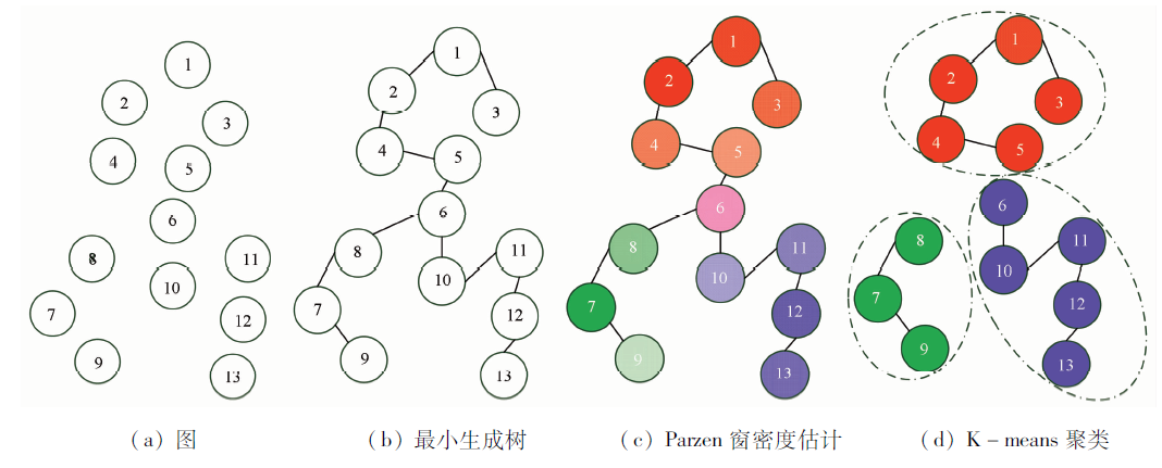
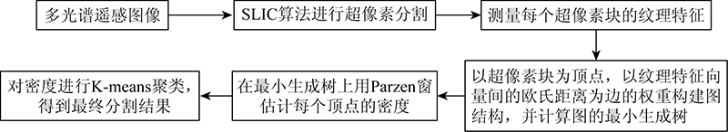
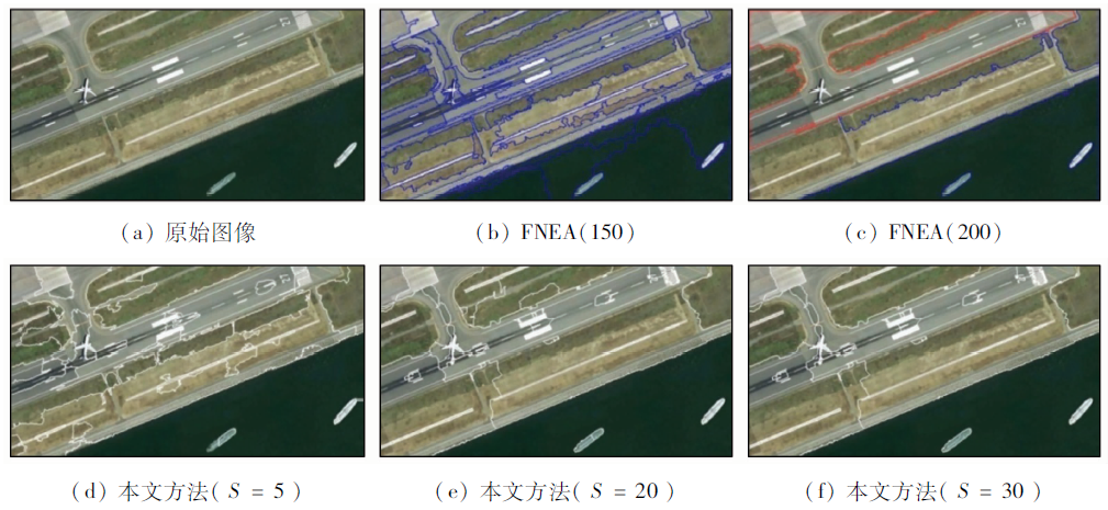
Abstract Image segmentation is a key step in the analysis of high-resolution remote sensing images and plays an important role in improving information extraction accuracy. To improve the performance of traditional pixel-based image segmentation methods, this study proposed a new algorithm based on Parzen window density estimation of super-pixel blocks. The new algorithm includes three main steps, namely super-pixel initial segmentation, feature measurement, and density estimation and re-clustering. In the first step, an image is coarsely divided using the simple linear iterative clustering (SLIC) algorithm, and each super-pixel block is marked as a node in the graph structure of the image. In the second step, the Gabor texture features of each super-pixel block are measured to construct high-dimension feature vectors. Meanwhile, the similarity of the image textures is calculated as the weight of the edge connecting two nodes in the graph. Then, the distance between the two nodes is calculated on the minimum spanning tree (MST) of the graph. In the third step, the calculated distance is used for Parzen window density estimation of each node, and re-clustering of the density values is conducted to obtain the final results. In the experiments, multiple multispectral high-resolution remote sensing images were adopted to verify the algorithm proposed in this study. Using visual discrimination and the quantitative evaluation based on precesion rate and recall rate, the segmentation results of the algorithm proposed in this study were compared with those of other algorithms. The experiments verified that the algorithm proposed in this study is effective.
|
| Keywords
multispectral remote sensing image
Parzen window density estimation
super-pixel
minimum spanning tree
image segmentation
region merging
|
|
|
|
Issue Date: 14 March 2022
|
|
|
| [1] |
Chehata N, Orny C, Boukir S, et al. Object-based change detection in wind storm-damaged forest using high-resolution multispectral images[J]. International Journal of Remote Sensing, 2014, 35(13):4758-4777.
doi: 10.1080/01431161.2014.930199
url: https://www.tandfonline.com/doi/full/10.1080/01431161.2014.930199
|
| [2] |
Gao L P, Shi W Z, Miao Z L, et al. Method based on edge constraint and fast marching for road centerline extraction from very high-resolution remote sensing images[J]. Remote Sensing, 2018, 10(6):900.
doi: 10.3390/rs10060900
url: http://www.mdpi.com/2072-4292/10/6/900
|
| [3] |
Porter S, Linderman M . Historic land cover change in the agricultural midwest using an object-based approach for classification of high-resolution imagery[J]. Journal of Applied Remote Sensing, 2013, 7(1):073506.
doi: 10.1117/1.JRS.7.073506
url: http://remotesensing.spiedigitallibrary.org/article.aspx?doi=10.1117/1.JRS.7.073506
|
| [4] |
黄鹏, 郑淇, 梁超. 图像分割方法综述[J]. 武汉大学学报(理学版), 2020,(6):519-531.
|
| [4] |
Huang P, Zheng Q, Liang C. Overview of image segmentation metho-ds[J]. Journal of Wuhan University(Natural Science Edition), 2020, 66(6):519-531.
|
| [5] |
Peng B, Zhang L, Zhang D. A survey of graph theoretical approaches to image segmentation[J]. Pattern Recognition, 2013, 46(3):1020-1038.
doi: 10.1016/j.patcog.2012.09.015
url: https://linkinghub.elsevier.com/retrieve/pii/S0031320312004219
|
| [6] |
Fan S, Sun Y, Shui P. Region-merging method with texture pattern attention for SAR image segmentation[J]. IEEE Geoscience and Remote Sensing Letters, 2020, 18(1):112-116.
doi: 10.1109/LGRS.8859
url: https://ieeexplore.ieee.org/xpl/RecentIssue.jsp?punumber=8859
|
| [7] |
Zhou C, Wu D, Qin W, et al. An efficient two-stage region merging method for interactive image segmentation[J]. Computers and Electrical Engineering, 2016, 54:220-229.
doi: 10.1016/j.compeleceng.2015.09.013
url: https://linkinghub.elsevier.com/retrieve/pii/S0045790615003201
|
| [8] |
Lassalle P, Inglada J, Michel J, et al. A scalable tile-based framework for region-merging segmentation[J]. IEEE Transactions on Geoscience and Remote Sensing, 2015, 53(10):5473-5485.
doi: 10.1109/TGRS.2015.2422848
url: http://ieeexplore.ieee.org/document/7101250/
|
| [9] |
黄亮, 姚丙秀, 陈朋弟, 等. 高分辨率遥感影像超像素的模糊聚类分割法[J]. 测绘学报, 2020, 49(5):589-597.
|
| [9] |
Huang L, Yao B X, Chen P D, et al. Superpixel segmentation method of high resolution remote sensing image based on fuzzy clustering[J]. Acta Geodaetica et Cartographica Sinica, 2020, 49(5):589-597.
|
| [10] |
An J, Shi Y, Han Y, et al. Extract and merge:Superpixel segmentation with regional attributes[C]// European Conference on Computer Vision.Springer, 2020:155-170.
|
| [11] |
Xu H, Zhang H, He W, et al. Superpixel-based spatial-spectral dimension reduction for hyperspectral imagery classification[J]. Neurocomputing, 2019, 360:138-150.
doi: 10.1016/j.neucom.2019.06.023
url: https://linkinghub.elsevier.com/retrieve/pii/S0925231219308501
|
| [12] |
Achanta R, Shaji A, Smith K, et al. SLIC Superpixels compared to state-of-the-art superpixel methods[J]. IEEE Transactions on Pattern Analysis and Machine Intelligence, 2012, 34(11):2274-2282.
doi: 10.1109/TPAMI.2012.120
url: http://ieeexplore.ieee.org/document/6205760/
|
| [13] |
Karydas C, Jiang B. Scale optimization in topographic and hydrographic feature mapping using fractal analysis[J]. International Journal of Geo-Information, 2020, 9(11):631.
|
| [14] |
Comaniciu D M P. A robust approach toward feature space analysis[J]. IEEE Transactions on Pattern Analysis and Machine Intelligence, 2002, 24(5):313-329.
doi: 10.1109/34.990134
url: http://ieeexplore.ieee.org/document/990134/
|
| [15] |
Park J H, Lee G S, Park S Y. Color image segmentation using adaptive mean shift and statistical model-based methods[J]. Computers and Mathematics with Applications, 2009, 57(6):970-980.
doi: 10.1016/j.camwa.2008.10.053
url: https://linkinghub.elsevier.com/retrieve/pii/S0898122108005798
|
| [16] |
Wang S, Chung F, Xiong F. A novel image thresholding method based on Parzen window estimate[J]. Pattern Recognition, 2008, 41(1):117-129.
doi: 10.1016/j.patcog.2007.03.029
url: https://linkinghub.elsevier.com/retrieve/pii/S0031320307001677
|
| [17] |
向日华, 王润生. 一种基于高斯混合模型的距离图像分割算法[J]. 软件学报, 2003, 14(7):1250-1257.
|
| [17] |
Xiang R H, Wang R S. A range image segmentation algorithm based on Gaussian mixture model[J]. Journal of Software, 2003, 14(7):1250-1257.
|
| [18] |
赵泉华, 石雪, 王玉, 等. 可变类空间约束高斯混合模型遥感图像分割[J]. 通信学报, 2017, 38(2):34-43.
|
| [18] |
Zhang Q H, Shi X, Wang Y, et al. Remote sensing image segmentation based on spatially constrained Gaussian mixture model with unknown class number[J]. Journal on Communications, 2017, 38(2):34-43.
|
| [19] |
Li W, Mao K, Zhang H, et al. Selection of Gabor filters for improved texture feature extraction[C]// 2010 IEEE International Conference on Image Processing.IEEE, 2010:361-364.
|
| [20] |
Parzen E. On estimation of a probability density function and mode[J]. Annals of Mathematical Statistics, 1962, 33(3):1065-1076.
doi: 10.1214/aoms/1177704472
url: http://projecteuclid.org/euclid.aoms/1177704472
|
| [21] |
Scott D W. Multivariate density estimation:Theory,practice,and visualization[M]. John Wiley and Sons, 2015.
|
| [22] |
Jones M C, Marron J S, Sheather S J. A brief survey of bandwidth selection for density estimation[J]. Journal of the American Statistical Association, 1996, 91(433):401-407.
doi: 10.1080/01621459.1996.10476701
url: http://www.tandfonline.com/doi/abs/10.1080/01621459.1996.10476701
|
| [23] |
Raykar V C, Duraiswami R. Fast optimal bandwidth selection for kernel density estimation[C]// Proceedings of the 2006 SIAM International Conference on Data Mining.Society for Industrial and Applied Mathematics, 2006:524-528.
|
| [24] |
Botev Z I, Kroese D P. Non-asymptotic bandwidth selection for density estimation of discrete data[J]. Methodology and Computing in Applied Probability, 2008, 10(3):435-451.
doi: 10.1007/s11009-007-9057-z
url: http://link.springer.com/10.1007/s11009-007-9057-z
|
| [25] |
Trudeau R J. Introduction to graph theory[M]. Courier Corporation, 2013.
|
| [26] |
Foulds L R. Graph theory applications[M]. Springer Science and Business Media, 2012.
|
| [27] |
Unnikrishnan R, Pantofaru C, Hebert M. Toward objective evaluation of image segmentation algorithms[J]. IEEE Transactions on Pattern Analysis and Machine Intelligence, 2007, 29(6):929-944.
pmid: 17431294
|
| [28] |
Gong C, Zhou P, Han J . Learning rotation-invariant convolutional neural networks for object detection in VHR optical remote sensing images[J]. IEEE Transactions on Geoscience and Remote Sensing, 2016, 54(12):7405-7415.
doi: 10.1109/TGRS.2016.2601622
url: http://ieeexplore.ieee.org/document/7560644/
|
| [29] |
Fang Y, Wang J. Selection of the number of clusters via the bootstrap method[J]. Computational Statistics and Data Analysis, 2012, 56(3):468-477.
doi: 10.1016/j.csda.2011.09.003
url: https://linkinghub.elsevier.com/retrieve/pii/S0167947311003215
|
| [30] |
Haslbeck J M B, Wulff D U. Estimating the number of clusters via a corrected clustering instability[J]. Computational Statistics, 2020(35):1879-1894.
|
| [31] |
青海玉树震后GeoEye-1卫星地图[EB/OL].(2010-04-20)[2021-02-15].http://www.godeyes.cn/html/2010/04/20/download_9519.html.
url: http://www.godeyes.cn/html/2010/04/20/download_9519.html.
|
| [31] |
GeoEye-1 satellite map after Yushu earthquake in Qinghai Province[EB/OL].(2010-04-20)[2021-02-15].http://www.godeyes.cn/html/2010/04/20/download_9519.html.
url: http://www.godeyes.cn/html/2010/04/20/download_9519.html.
|
|
Viewed |
|
|
|
Full text
|
|
|
|
|
Abstract
|
|
|
|
|
Cited |
|
|
|
|
| |
Shared |
|
|
|
|
| |
Discussed |
|
|
|
|
 2022,
Vol. 34
2022,
Vol. 34