|
|
 |
|

|
|
|
Assessing the susceptibility of slope geological hazards based on multi-source heterogeneous data: A case study of Longgang District, Shenzhen City |
WANG Ning1( ), JIANG Decai1,2,3, ZHENG Xiangxiang1,2,4, ZHONG Chang1,5() ), JIANG Decai1,2,3, ZHENG Xiangxiang1,2,4, ZHONG Chang1,5() |
1. China Aero Geophysical Survey and Remote Sensing Center for Natural Resources, Beijing 100083, China
2. University of Chinese Academy of Sciences, Beijing 100049, China
3. Northwest Institute of Eco-Environment and Resources, Chinese Academy of Sciences, Lanzhou 730000,China
4. Aerospace Information Research Institute, Chinese Academy of Sciences, Beijing 100094, China
5. College of Intelligence Science and Technology,National University of Defense Technology, Changsha 410073, China |
|
|
|
|
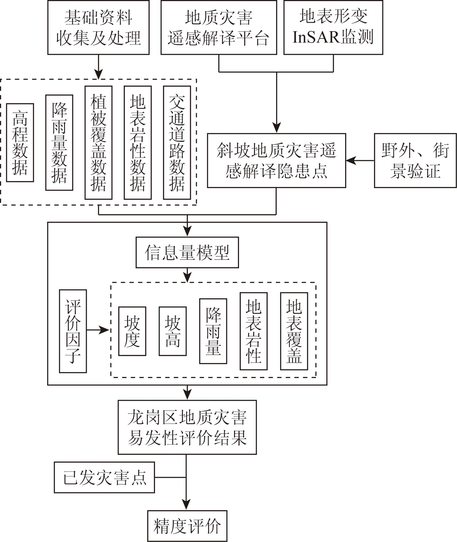
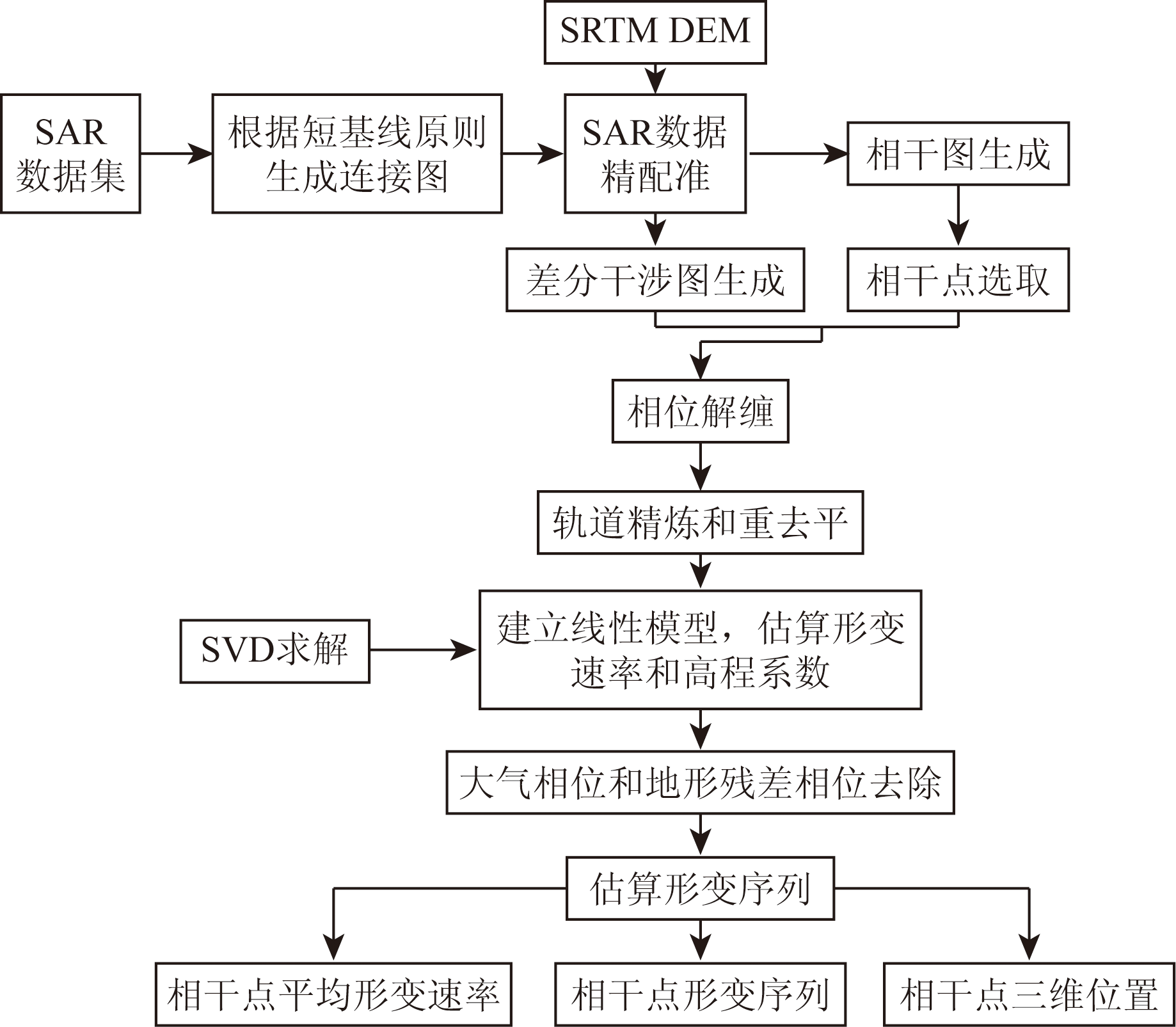
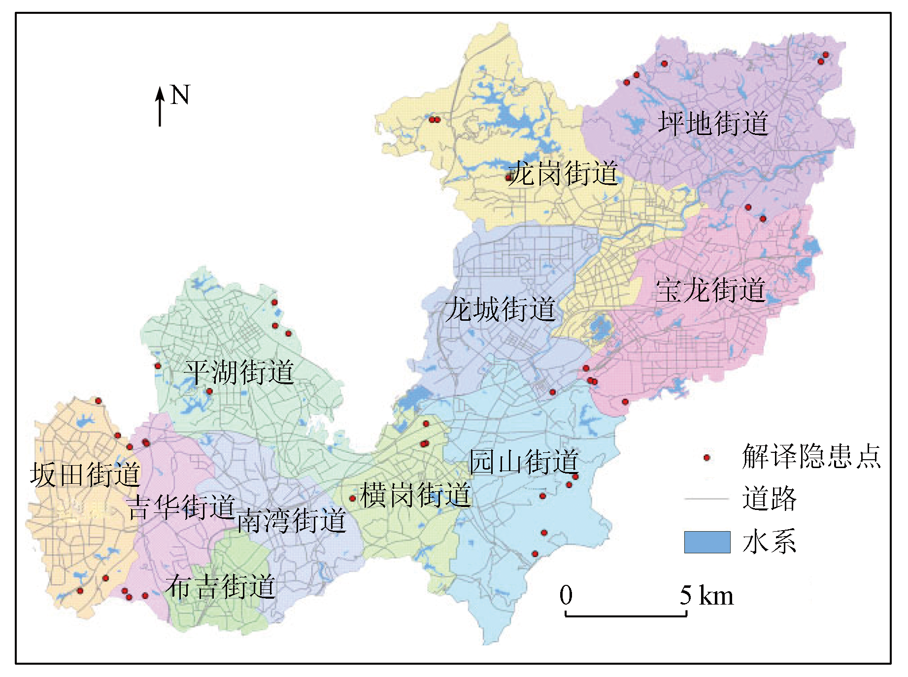
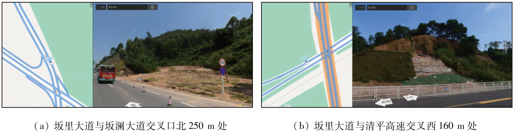
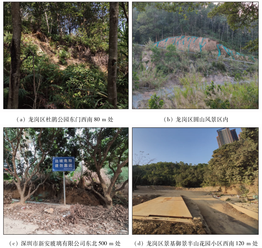
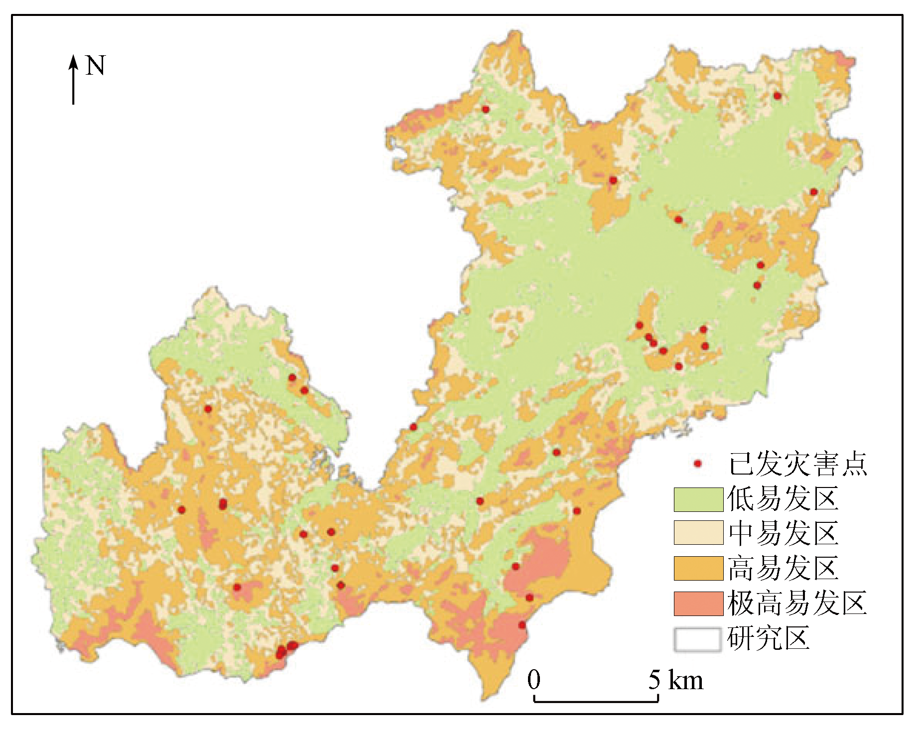
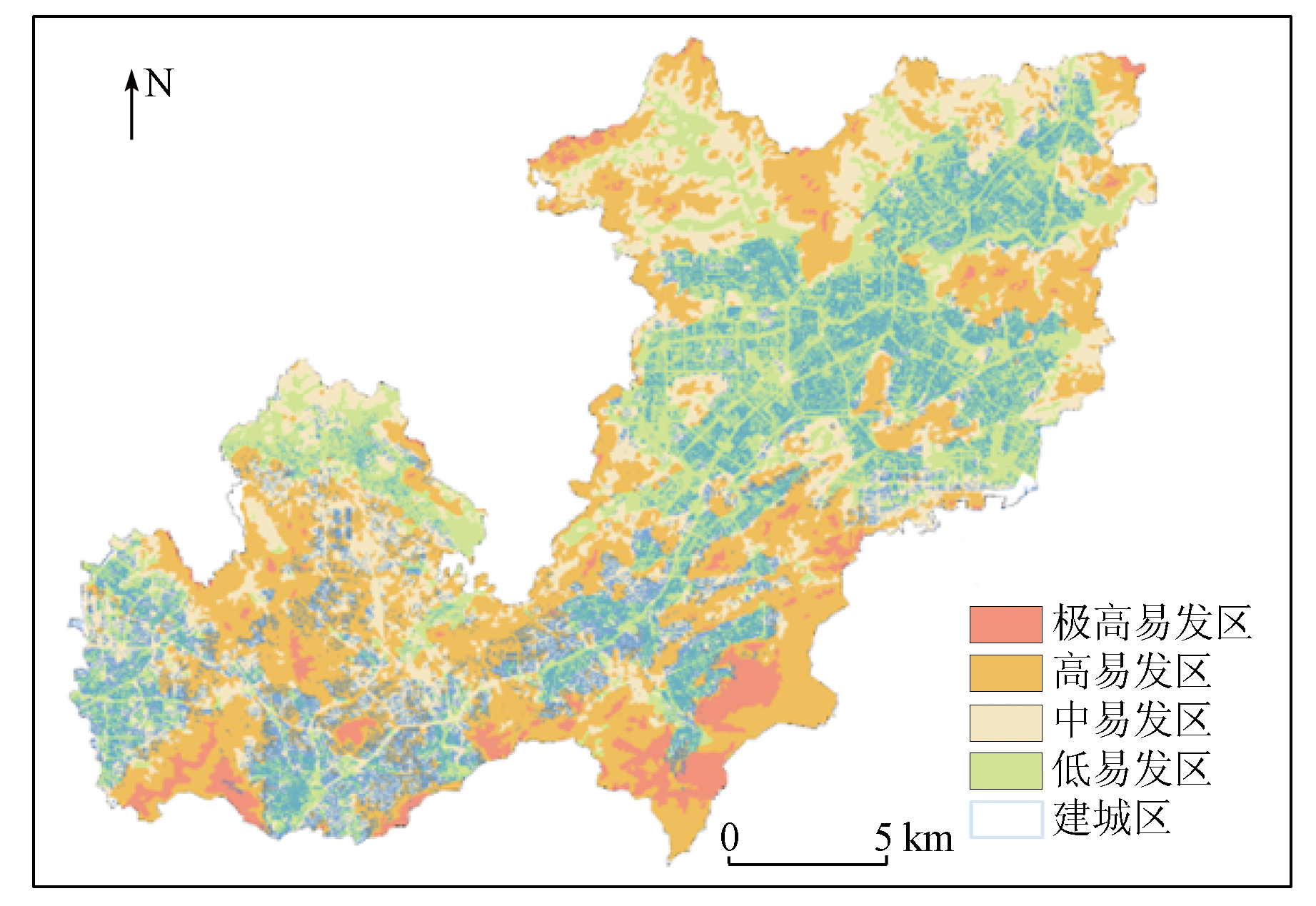
Abstract This study aims to investigate the fundamental facts concerning slope geological hazards in Longgang District, Shenzhen City, as well as the distributions of disaster-prone zones in the district. Based on the multi-source remote sensing satellite data, this study interpreted the slope geological hazards using the expert interpretation method on a geological hazard interpretation platform. Furthermore, some interpreted geological hazards were verified through field verification combined with Baidu Street View data. Finally, the distributions of zones susceptible to slope geological hazards in Longgang District were determined using the information value method, with the slope height, slope gradient, rainfall, surface lithology, and land cover as assessment factors. Additionally, existing geological hazard sites were superimposed with the susceptibility assessment results for analysis, yielding completely consistent results. This confirms the effectiveness of the method used in this study for assessing the susceptibility of slope geological hazards, as well as the accuracy of remote sensing interpretation of slope geological hazards.
|
| Keywords
identification of geological hazards
time-series InSAR
susceptibility assessment
information value model
|
|
|
|
Issue Date: 21 December 2023
|
|
|
| [1] |
吴志斌. 深圳龙岗区突发性地质灾害成因浅析[J]. 中国水运(理论版), 2006(2):104-105.
|
| [1] |
Wu Z B. Analysis on the causes of sudden geological disasters in Longgang District,Shenzhen[J]. China Water Transport(Theory Edition), 2006(2):104-105.
|
| [2] |
熊金安, 汪磊. 深圳斜坡类地质灾害特征及成因分析[J]. 地质灾害与环境保护, 2013, 24(3):70-75.
|
| [2] |
Xing J A, Wang L. Characteristics and causes of slope geo-hazards in Shenzhen[J]. Journal of Geological Hazards and Environment Preservation, 2013, 24(3):70-75.
|
| [3] |
姚玲, 雷呈斌, 王明龙, 等. 基于RS和GIS技术的深圳市斜坡类地质灾害易发程度评价[J]. 河南理工大学学报(自然科学版), 2017, 36(3):66-72.
|
| [3] |
Yao L, Lei C B, Wang M L, et al. Evaluation of the susceptibility of slope disasters in Shenzhen City based on RS and GIS technique[J]. Journal of Henan Polytechnic University(Natural Science), 2017, 36(3):66-72.
|
| [4] |
薛强, 张茂省, 李林. 基于斜坡单元与信息量法结合的宝塔区黄土滑坡易发性评价[J]. 地质通报, 2015, 34(11):2108-2115.
|
| [4] |
Xue Q, Zhang M S, Li L. Loess landslide susceptibility evaluation based on slope unit and information value method in Baota District,Yan’an[J]. Geological Bulletin of China, 2015, 34(11):2108-2115.
|
| [5] |
张向营, 张春山, 孟华君, 等. 基于GIS和信息量模型的京张高铁滑坡易发性评价[J]. 地质力学学报, 2018, 24(1):96-105.
|
| [5] |
Zhang X Y, Zhang C S, Meng H J, et al. Landslide susceptibility assessment of new Jing-zhang high-speed railway based on GIS and information value model[J]. Journal of Geomechanics, 2018, 24(1):96-105.
|
| [6] |
邓辉, 何政伟, 陈晔, 等. 信息量模型在山地环境地质灾害危险性评价中的应用——以四川泸定县为例[J]. 自然灾害学报, 2014, 23(2):67-76.
|
| [6] |
Deng H, He Z W, Chen Y, et al. Application of information quantity model to hazard evaluation of geological disaster in mountainous region environment:A case study of Luding County,Sichuan Province[J]. Journal of Natural Disasters, 2014, 23(2):67-76.
|
| [7] |
杨根云, 周伟, 方教勇. 基于信息量模型和数据标准化的滑坡易发性评价[J]. 地球信息科学学报, 2018, 20(5):674-683.
doi: 10.12082/dqxxkx.2018.170535
|
| [7] |
Yang G Y, Zhou W, Fang J Y. Assessment of landslide susceptibility based on information quantity model and data normalization[J]. Journal of Geo-Information Science, 2018, 20(5):674-683.
|
| [8] |
王兵, 李爱军, 黄丽. 局域层次分析法(AHP)的地质灾害易发性评价研究[J]. 资源环境与工程, 2013, 27(2):179-183.
doi: 10.16536/j.cnki.issn.1671-1211.2013.02.014
|
| [8] |
Wang B, Li A J, Huang L. Evaluation of geological disasters susceptibility by local analytic hierarchy process (AHP)[J]. Resources Environment and Engineering, 2013, 27(2):179-183.
|
| [9] |
陈绪钰, 李明辉, 王德伟, 等. 基于GIS和信息量法的四川峨眉山市地质灾害易发性定量评价[J]. 沉积与特提斯地质, 2019, 39(4):100-112.
|
| [9] |
Chen X Y, Li M H, Wang D W, et al. Quantitative evalution of geohazards susceptibility based on GIS and information value model for Emeishan City,Sichuan[J]. Sedimentary Geology and Tethyan Geo-logy, 2019, 39(4):100-112.
|
| [10] |
文海家, 胡东萍, 王桂林. 汶川县地震滑坡易发性LR与NN评价比较研究[J]. 土木工程学报, 2014, 47(s1):17-23.
|
| [10] |
Wen H J, Hu D P, Wang G L. A comparative study on the susceptibility mapping of earthquake triggered landslide by neural network and logistic regression model,Wenchuan County[J]. China Civil Engineering Journal, 2014, 47(s1):17-23.
|
| [11] |
黄发明, 殷坤龙, 蒋水华, 等. 基于聚类分析和支持向量机的滑坡易发性评价[J]. 岩石力学与工程学报, 2018, 37(1):156-167.
|
| [11] |
Huang F M, Yin K L, Jiang S H, et al. Landslide susceptibility assessment based on clustering analysis and support vector machine[J]. Chinese Journal of Rock Mechanics and Engineering, 2018, 37(1):156-167.
|
| [12] |
自然资源部. FXPC/ZRZY P-01 地质灾害风险调查评价技术要求(1:50 000)[R]. 北京: 自然资源部, 2021.
|
| [12] |
Ministry of Natural Resources. FXPC/ZRZY P-01 Technical requirements for geological hazard risk investigation and evaluation(1∶50 000)[R]. Beijing: Ministry of Natural Resources, 2021.
|
| [13] |
童立强, 郭兆成. 典型滑坡遥感影像特征研究[J]. 国土资源遥感, 2013, 25(1): 86-92.doi:10.6046/gtzyyg.2013.01.16.
|
| [13] |
Tong L Q, Guo Z C. A study of remote sensing image features of typical landslides[J]. Remote Sensing for Land and Resources, 2013, 25(1):86-92.doi:10.6046/gtzyyg.2013.01.16.
|
| [14] |
张路, 廖明生, 董杰, 等. 基于时间序列InSAR分析的西部山区滑坡灾害隐患早期识别——以四川丹巴为例[J]. 武汉大学学报(信息科学版), 2018, 43(12):2039-2049.
|
| [14] |
Zhang L, Liao M S, Dong J, et al. Early detection of landslide hazards in mountainous areas of west China using time series SAR interferometry:A case study of Danba,Sichuan[J]. Geomatics and Information Science of Wuhan University, 2018, 43(12):2039-2049.
|
| [15] |
苏晓军, 张毅, 贾俊, 等. 基于 InSAR 技术的秦岭南部略阳县潜在滑坡灾害识别研究[J]. 山地学报, 2021, 39(1): 59-70.
|
| [15] |
Su X J, Zhang Y, Jia J, et al. InSAR-based monitoring and identification of potential landslides in Lueyang County,the Southern Qinling Mountains,China[J]. Mountain Research, 2021, 39(1):59-70.
|
| [16] |
陆会燕, 李为乐, 许强, 等. 光学遥感与InSAR结合的金沙江白格滑坡上下游滑坡隐患早期识别[J]. 武汉大学学报(信息科学版), 2019, 44(9):1342-1354.
|
| [16] |
Lu H Y, Li W L, Xu Q, et al. Early detection of landslides in the upstream and downstream areas of the Baige landslide,the Jinsha River based on optical remote sensing and InSAR technologies[J]. Geomatics and Information Science of Wuhan University, 2019, 44(9):1342-1354.
|
| [17] |
Ferretti A, Prati C, Rocca F. Nonlinear subsidence rate estimation using permanent scatterers in differential SAR interferometry[J]. IEEE Transactions on Geoscience and Remote Sensing, 2000, 38(5):2202-2212.
doi: 10.1109/36.868878
url: http://ieeexplore.ieee.org/document/868878/
|
| [18] |
Ferretti A, Prati C, Rocca F. Permanent scatterers in SAR interfero-metry[J]. IEEE Transactions on Geoscience and Remote Sensing, 2001, 39(1):8-20.
doi: 10.1109/36.898661
url: http://ieeexplore.ieee.org/document/898661/
|
| [19] |
姜德才, 郑向向, 王宁, 等. 时序InSAR技术在珠三角地区地质灾害隐患识别中的应用[J]. 自然资源遥感, 2023, 25(3):292-301.doi:10.6046/zrzyyg.2022190.
|
| [19] |
Jiang D C, Zheng X X, Wang N, et al. Application of time series InSAR technology in the identification of geological hazards in Pearl River Delta region[J]. Remote Sensing for Natural Resources, 2023, 25(3):292-301.doi:10.6046/zrzyyg.2022190.
|
|
Viewed |
|
|
|
Full text
|
|
|
|
|
Abstract
|
|
|
|
|
Cited |
|
|
|
|
| |
Shared |
|
|
|
|
| |
Discussed |
|
|
|
|
 2023,
Vol. 35
2023,
Vol. 35