|
|
|
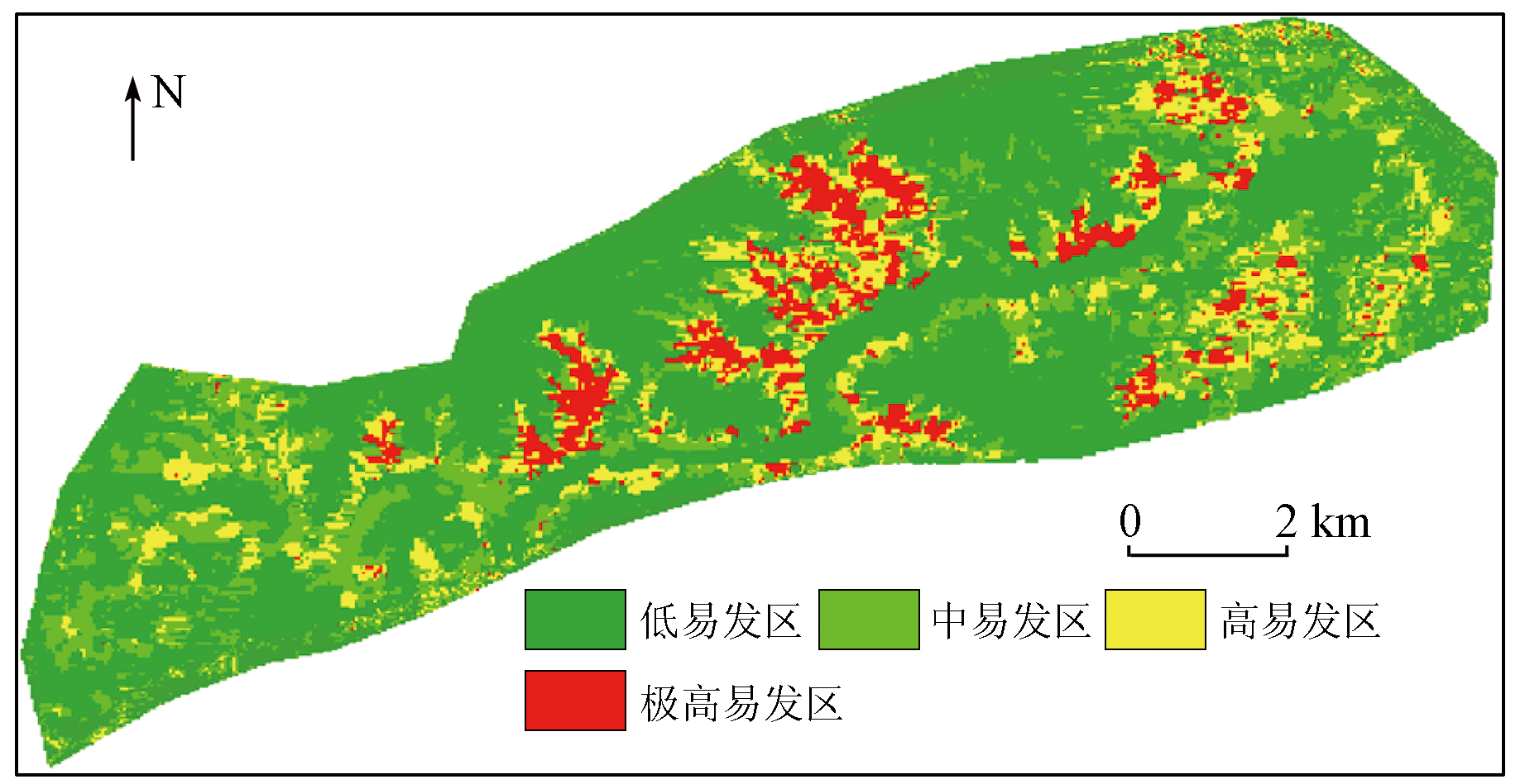
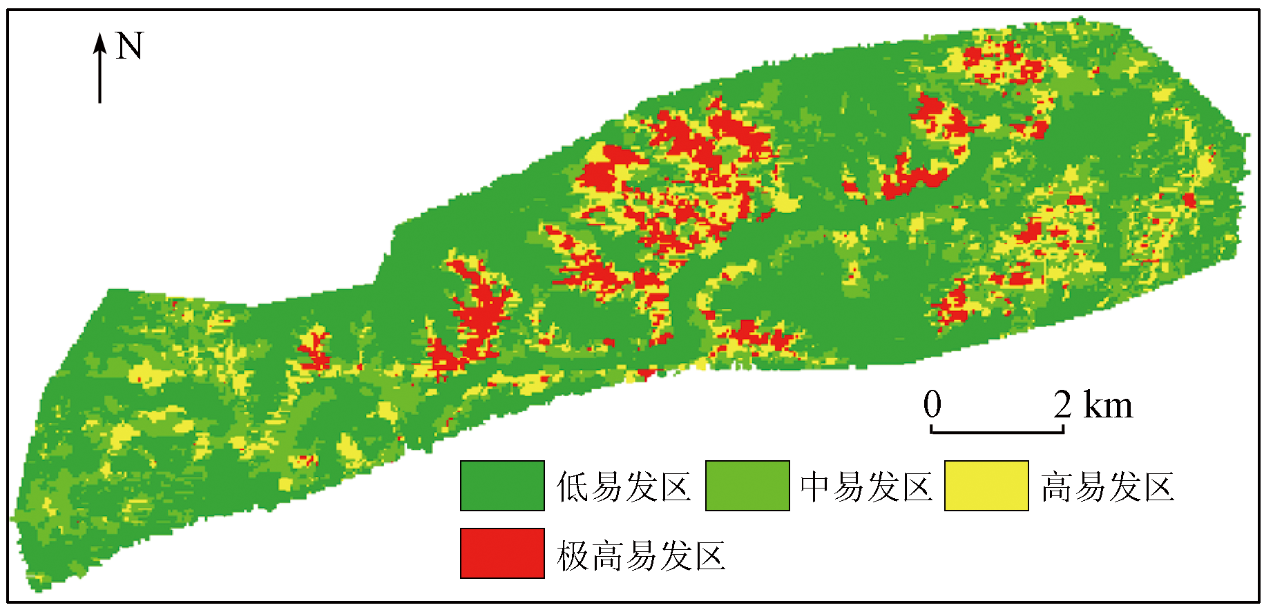
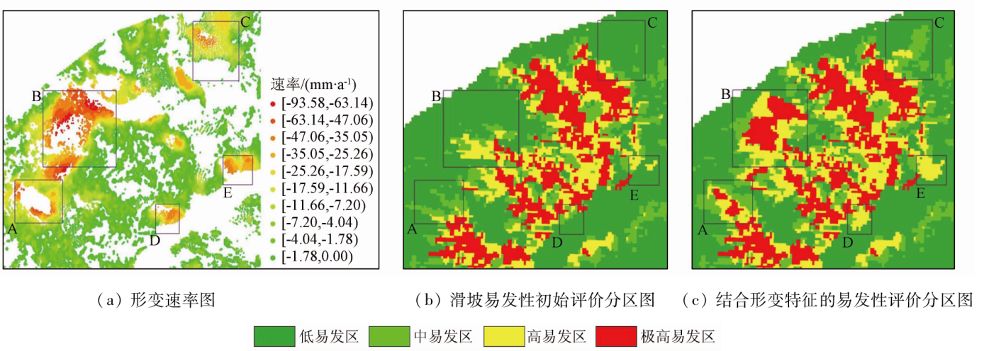
Abstract Assessing the landslide susceptibility of highways in precarious mountainous areas can provide crucial information for the geologic route selection of highways. Conventional landslide susceptibility assessment methods ignore the application of surface deformation data and other dynamic data, leading to low-accuracy assessment results. Hence, this study proposed a landslide susceptibility assessment method for mountain highways based on optical and SAR remote sensing images. With the Longwuxia-Gongboxia section of the Yanhuang Highway in Qinghai Province as the study area, this study extracted various static factors of landslides from high-resolution QuickBird satellite images and calculated the initial risk level of landslide susceptibility within the route area using a random forest model. Afterward, this study obtained the surface deformation factors, which directly reflect the dynamic changes of landslides, based on the long-time-series Sentinel-1A images. Finally, this study corrected the initial landslide susceptibility risk level based on the surface deformation factors, generating a landslide susceptibility assessment zoning map. As demonstrated by engineering practice, the method proposed in this study yielded a high-accuracy landslide susceptibility assessment zoning map for the mountain highway by combining data on both static and dynamic factors of landslides, thus providing accurate information for subsequent geologic route selection of the highway.
|
| Keywords
landslide susceptibility assessment
optical remote sensing
SAR
mountain highway
random forest
|
|
|
|
Issue Date: 21 December 2023
|
|
|
| [1] |
李文娟, 邵海. 基于遥感影像多尺度分割与地质因子评价的滑坡易发性区划[J]. 中国地质灾害与防治学报, 2021, 32(2):94-99.
|
| [1] |
Li W J, Shao H. Landslide susceptibility assessment based on multi-scale segmentation of remote sensing and geological factor eValuation[J]. The Chinese Journal of Geological Hazard and Control, 2021, 32(2):94-99.
|
| [2] |
黄海峰, 薛蓉花, 赵蓓蓓, 等. 孕灾机理与综合遥感结合的三峡库首顺层岩质滑坡隐患识别[J]. 测绘学报, 2022, 51(10):2056-2068.
doi: 10.11947/j.AGCS.2022.20220306
|
| [2] |
Huang H F, Xue R H, Zhao B B, et al. The bedding rock landslide identification in the head area of the Three Gorges Reservoir combined with disaster pregnant mechanism and comprehensive remote sensing method[J]. Acta Geodaetica et Cartographica Sinica, 2022, 51(10):2056-2068.
doi: 10.11947/j.AGCS.2022.20220306
|
| [3] |
贾伟洁, 王治华. 基于高分辨率遥感影像的滑坡活动特征及稳定性分析——以东苗家滑坡为例[J]. 国土资源遥感, 2019, 31(4):174-181.doi:10.6046/gtzyyg.2019.04.23.
|
| [3] |
Jia W J, Wang Z H. Landslide activity characteristics and stability analysis based on high-resolution remote sensing image:A case study of Dongmiaojia landslide[J]. Remote Sensing for Land and Resources, 2019, 31(4):174-181.
|
| [4] |
Youssef A M, Pourghasemi H R. Landslide susceptibility mapping using machine learning algorithms and comparison of their performance at Abha Basin,Asir Region,Saudi Arabia[J]. Geoscience Frontiers, 2021, 12(2):639-655.
doi: 10.1016/j.gsf.2020.05.010
url: https://linkinghub.elsevier.com/retrieve/pii/S1674987120301298
|
| [5] |
胡致远, 罗文强, 晏鄂川, 等. 基于改进层次分析法的英山县地质灾害易发性评价[J]. 安全与环境工程, 2018, 25(4):28-32.
|
| [5] |
Hu Z Y, Luo W Q, Yan E C, et al. IAHP-based evaluation of susceptibility of geological hazards in Yingshan County[J]. Safety and Environmental Engineering, 2018, 25(4):28-32.
|
| [6] |
刘阳. 延长县滑坡地质灾害风险评估和管理研究[D]. 西安: 长安大学, 2009.
|
| [6] |
Liu Y. The extention of geologal disasters of landslide risk assessment and management research in the Yanchang County[D]. Xi’an: Changan University, 2009.
|
| [7] |
Hong H, Chen W, Xu C, et al. Rainfall-induced landslide susceptibility assessment at the Chongren area (China) using frequency ratio,certainty factor,and index of entropy[J]. Geocarto International, 2017, 32(2):139-154.
|
| [8] |
周晓亭, 黄发明, 吴伟成, 等. 基于耦合信息量法选择负样本的区域滑坡易发性预测[J]. 工程科学与技术, 2022, 54(3):25-35.
|
| [8] |
Zhou X T, Huang F M, Wu W C, et al. Regional landslide susceptibility prediction based on negative sample selected by coupling information value method[J]. Advanced Engineering Sciences, 2022, 54(3):25-35.
|
| [9] |
刘月, 王宁涛, 周超, 等. 基于ROC曲线与确定性系数法集成模型的三峡库区奉节县滑坡易发性评价[J]. 安全与环境工程, 2020, 27(4):61-70.
|
| [9] |
Liu Y, Wang N T, Zhou C, et al. Evaluation of landslide susceptibility based on ROC and certainty factor method in Fengjie County,Three Gorges Reservoir[J]. Safety and Environmental Engineering, 2020, 27(4):61-70.
|
| [10] |
杨昭颖, 韩灵怡, 郑向向, 等. 基于卷积神经网络的遥感影像及DEM滑坡识别——以黄土滑坡为例[J]. 自然资源遥感, 2022, 34(2):224-230.doi:10.6046/zrzyyg.2021204.
|
| [10] |
Yang Z Y, Han L Y, Zheng X X, et al. Landslide identification using remote sensing images and DEM based on convolutional neural network:A case study of loess landslide[J]. Remote Sensing for Natural Resources, 2022, 34(2):224-230.doi:10.6046/zrzyyg.2021204.
|
| [11] |
刘纪平, 梁恩婕, 徐胜华, 等. 顾及样本优化选择的多核支持向量机滑坡灾害易发性分析评价[J]. 测绘学报, 2022, 51(10): 2034-2045.
doi: 10.11947/j.AGCS.2022.20220326
|
| [11] |
Liu J P, Liang E J, Xu S H, et al. Multi-kernel support vector machine considering sample optimization selection for analysis and evaluation of landslide disaster susceptibility[J]. Acta Geodaetica et Cartographica Sinica, 2022, 51(10):2034-2045.
doi: 10.11947/j.AGCS.2022.20220326
|
| [12] |
吴润泽, 胡旭东, 梅红波, 等. 基于随机森林的滑坡空间易发性评价: 以三峡库区湖北段为例[J]. 地球科学, 2021, 46(1):321-330.
|
| [12] |
Wu R Z, Hu X D, Mei H B, et al. Spatial susceptibility assessment of landslides based on random forest: A case study from Hubei section in the Three Gorges Reservoir area[J]. Earth Science, 2021, 46(1):321-330.
|
| [13] |
徐乔, 余飞, 余绍淮. 基于多源遥感数据的山区铁路滑坡危险性评价[J]. 铁道工程学报, 2021, 38(11):8-14.
|
| [13] |
Xu Q, Yu F, Yu S H. Landslide hazard assessment of mountain railways based on multi-source remote sensing data[J]. Journal of Railway Engineering Society, 2021, 38(11):8-14.
|
| [14] |
王卫东, 何卓磊, 韩征, 等. 基于深度信念网络的滑坡敏感性评价[J]. 东北大学学报(自然科学版), 2020, 41(5):609-615.
doi: 10.12068/j.issn.1005-3026.2020.05.001
|
| [14] |
Wang W D, He Z L, Han Z, et al. Landslides susceptibility assessment based on deep belief network[J]. Journal of Northeastern University( Natural Science), 2020, 41(5):609-615.
|
| [15] |
余绍淮, 徐乔, 罗博仁. 时序InSAR技术在山区公路遥感地质勘察中的应用[J]. 公路, 2021, 66(10):251-257.
|
| [15] |
Yu S H, Xu Q, Luo B R. Application of time series InSAR technology in remote sensing geological survey of mountainous highway[J]. Highway, 2021, 66(10):251-257.
|
| [16] |
赵富萌, 张毅, 孟兴民, 等. 基于小基线集雷达干涉测量的中巴公路盖孜河谷地质灾害早期识别[J]. 水文地质工程地质, 2020, 47(1): 142-152.
|
| [16] |
Zhao F M, Zhang Y, Meng X M, et al. Early identification of geological hazards in the Gaizi valley near the Karakoran Highway based on SBAS-InSAR technology[J]. Hydrogeology & Engineering Geology, 2020, 47(1):142-152.
|
| [17] |
张腾, 谢帅, 黄波, 等. 利用Sentinel-1和ALOS-2数据探测茂县中部活动滑坡[J]. 国土资源遥感, 2021, 33(2):213-219.doi:10.6046/gtzyyg.2020206.
|
| [17] |
Zhang T, Xie S, Huang B, et al. Detection of active landslides in central Maoxian County using Sentinel-1 and ALOS-2 data[J]. Remote Sensing for Land and Resources, 2021, 33(2):213-219.doi:10.6046/gtzyyg.2020206.
|
| [18] |
朱玉. 基于PS-InSAR的贵州省大方县、纳雍县滑坡易发性评价[D]. 北京: 中国地质大学(北京), 2020.
|
| [18] |
Zhu Y. Landslide susceptibility assessment of Dafang and Nayong County of Guizhou Province combining with PS-InSAR[D]. Beijing: China University of Geosciences(Beijing), 2020.
|
| [19] |
杨强. 基于时序InSAR技术的皮力青河流域滑坡易发性研究[D]. 成都: 成都理工大学, 2019.
|
| [19] |
Yang Q. Research on landslide susceptibility based on time series InSAR technology in PiLi Qing River Basin[D]. Chengdu: Chengdu University of Technology, 2019.
|
| [20] |
徐乔, 张霄, 余绍淮, 等. 综合多特征的极化SAR图像随机森林分类算法[J]. 遥感学报, 2019, 23(4): 685-694.
|
| [20] |
Xu Q, Zhang X, Yu S H, et al. Multi-feature-based classification method using random forest and superpixels for polarimetric SAR images[J]. Journal of Remote Sensing, 2019, 23(4):685-694.
|
| [21] |
柳明星, 刘建红, 马敏飞, 等. 基于GF-2 PMS影像和随机森林的甘肃临夏花椒树种植监测[J]. 自然资源遥感, 2022, 34(1):218-229.doi:10.6046/zrzyyg.2021112.
|
| [21] |
Liu M X, Liu J H, Ma M F, et al. Monitoring of Zanthoxylum bungeanum Maxim planting using GF-2 PMS images and the random forest algorithm:A case study of Linxia,Gansu Province[J]. Remote Sensing for Natural Resources, 2022, 34(1):218-229.doi:10.6046/zrzyyg.2021112.
|
| [22] |
Ferretti A, Prati C, Rocca F, et al. Permanent scatters in SAR Interferometry[J]. IEEE Transactions on Geoscience and Remote Sensing, 2001, 39(1):8-20.
doi: 10.1109/36.898661
url: http://ieeexplore.ieee.org/document/898661/
|
| [23] |
Berardino P, Fornaro G, Lanari R, et al. A new algorithm for surface deformation monitoring based on small baseline differential SAR interferograms[J]. IEEE Transactions on Geoscience and Remote Sensing, 2002, 40(11):2375-2383.
doi: 10.1109/TGRS.2002.803792
url: http://ieeexplore.ieee.org/document/1166596/
|
| [24] |
张诗茄, 蒋建军, 缪亚敏, 等. 基于SBAS技术的岷江流域潜在滑坡识别[J]. 山地学报, 2018, 36(1):91-97.
|
| [24] |
Zhang S J, Jiang J J, Miao Y M, et al. Application of the SBAS technique in potential landslide identification in the Minjiang watershed[J]. Mountain Research, 2018, 36(1):91-97.
|
| [25] |
Herrera G, Gutiérrez F, García-Davalillo J C, et al. Multi-sensor advanced DInSAR monitoring of very slow landslides:The Tena Valley case study (Central Spanish Pyrenees)[J]. Remote Sensing of Environment, 2013, 128:31-43.
doi: 10.1016/j.rse.2012.09.020
url: https://linkinghub.elsevier.com/retrieve/pii/S003442571200380X
|
| [26] |
张玘恺, 凌斯祥, 李晓宁, 等. 九寨沟县滑坡灾害易发性快速评估模型对比研究[J]. 岩石力学与工程学报, 2020, 39(8):1595-1610.
|
| [26] |
Zhang Q K, Ling S X, Li X N, et al. Comparison of landslide susceptibility mapping rapid assessment models in Jiuzhaigou County,Sichuan Province,China[J]. Chinese Journal of Rock Mechanics and Engineering, 2020, 39(8):1595-1610.
|
| [27] |
周超. 集成时间序列InSAR技术的滑坡早期识别与预测研究[D]. 武汉: 中国地质大学, 2018.
|
| [27] |
Zhou C. Landslide identification and prediction with the application of time series InSAR[D]. Wuhan: China University of Geosciences, 2018.
|
|
Viewed |
|
|
|
Full text
|
|
|
|
|
Abstract
|
|
|
|
|
Cited |
|
|
|
|
| |
Shared |
|
|
|
|
| |
Discussed |
|
|
|
|
 2023,
Vol. 35
2023,
Vol. 35
 ), XU Qiao(