|
|
 |
|

|
|
|
Global sharing system of Earth simulation data in the Coupled Model Intercomparison Project |
LIU Yufu1( ), BAI Yuqi1,2() ), BAI Yuqi1,2() |
1. Department of Earth System Science, Ministry of Education Ecological Field Station for East Asian Migratory Birds and Their Habitatses, Institute for Global Change Studies, Tsinghua University, Beijing 100084, China
2. Tsinghua Urban Institute, Tsinghua University, Beijing 100084, China |
|
|
|
|
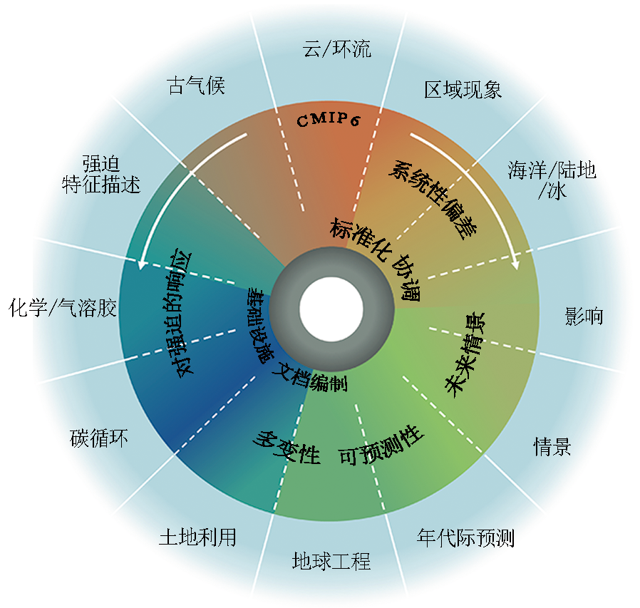
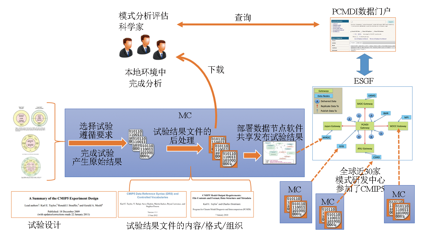
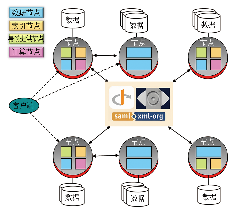
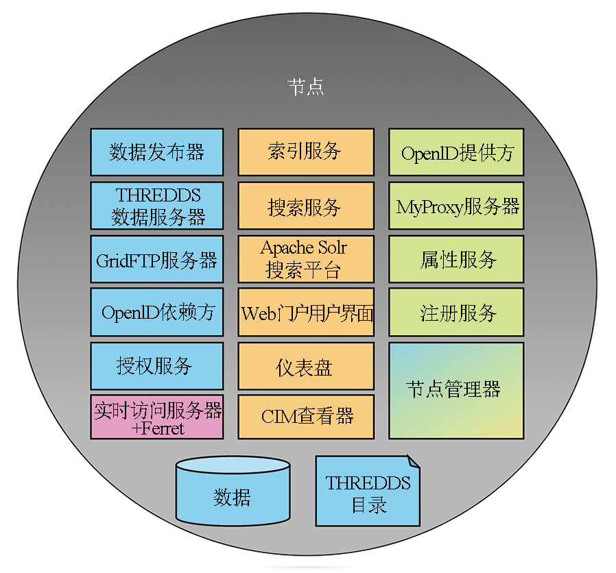
Abstract Remote sensing-based Earth observation and Earth system numerical simulation serve as two significant technical means in revealing the Earth’s environmental changes and predicting its future states. Hence, they assist in enhancing the capacity of human society to mitigate and adapt to global change and in ensuring the sustainable development of the natural environment and human society. The Coupled Model Intercomparison Project (CMIP) is a large-scale international collaboration project in the field of Earth system numerical simulation, aiming to coordinate various countries to complete the simulations of the Earth’s historical environment and the predictions of its future states. The Earth simulation data generated in the CMIP directly support the global climate change assessments of the Intergovernmental Panel on Climate Change (IPCC), United Nations, providing a solid scientific basis for global climate negotiations and governance. The CMIP Phase 6 (CMIP6) has generated up to 30 petabytes (PB) of Earth simulation data. The management and sharing of these data are achieved through the Earth System Grid Federation (ESGF). This study elucidates the CMIP organizational scheme, the ESGF system architecture, and the sharing and interoperability progress of Earth simulation data. It can provide a reference for planning, designing, and operating large-scale networks for sharing remote sensing science data.
|
| Keywords
Coupled Model Intercomparison Project (CMIP)
Earth System Grid Federation (ESGF)
climate model data
data sharing
|
|
|
|
Issue Date: 31 December 2025
|
|
|
| [1] |
周天军, 邹立维, 陈晓龙. 第六次国际耦合模式比较计划(CMIP6)评述[J]. 气候变化研究进展, 2019, 15(5):445-456.
|
| [1] |
Zhou T J, Zou L W, Chen X L. Commentary on the coupled model intercomparison project phase 6 (CMIP6)[J]. Climate Change Research, 2019, 15(5):445-456.
|
| [2] |
Eyring V, Bony S, Meehl G A, et al. Overview of the Coupled Model Intercomparison Project Phase 6 (CMIP6) experimental design and organization[J]. Geoscientific Model Development, 2016, 9(5):1937-1958.
doi: 10.5194/gmd-9-1937-2016
url: https://gmd.copernicus.org/articles/9/1937/2016/
|
| [3] |
赵宗慈, 罗勇, 黄建斌. CMIP6的设计[J]. 气候变化研究进展, 2016, 12(3):258-260.
|
| [3] |
Zhao Z C, Luo Y, Huang J B. Design of CMIP6[J]. Climate Change Research, 2016, 12(3):258-260.
|
| [4] |
马强, 颜京辉, 魏敏, 等. 北京气候中心CMIP6数据共享平台及应用[J]. 应用气象学报, 2022, 33(5):617-627.
|
| [4] |
Ma Q, Yan J H, Wei M, et al. Implementation and application of BCC CMIP6 experimental data sharing platform[J]. Journal of Applied Meteorological Science, 2022, 33(5):617-627.
|
| [5] |
Balaji V, Taylor K E, Juckes M, et al. Requirements for a global data infrastructure in support of CMIP6[J]. Geoscientific Model Development, 2018, 11(9):3659-3680.
doi: 10.5194/gmd-11-3659-2018
url: https://gmd.copernicus.org/articles/11/3659/2018/
|
| [6] |
Cinquini L, Crichton D, Mattmann C, et al. The Earth System Grid Federation:An open infrastructure for access to distributed geospatial data[J]. Future Generation Computer Systems, 2014,36:400-417.
|
| [7] |
Williams D N, Taylor K E, Cinquini L, et al. The Earth System Grid Federation:Software Framework Supporting CMIP5 Data Analysis and Dissemination[J]. CLIVAR Exchanges, 2011, 16(2):40-42.
|
| [8] |
Petrie R, Denvil S, Ames S, et al. Coordinating an operational data distribution network for CMIP6 data[J]. Geoscientific Model Development, 2021, 14(1):629-644.
doi: 10.5194/gmd-14-629-2021
|
| [9] |
Climate Europe. European Earth System Modelling for Climate Services[EB/OL]. https://www.climateurope.eu/european-earth-system-modelling-for-climate-services/ (Accessed on 24 May 2024).
url: https://www.climateurope.eu/european-earth-system-modelling-for-climate-services/
|
| [10] |
Earth System Grid Federation, Federation Design. ESGF GitHub Documentation[EB/OL].https://esgf.github.io/federation-design.html.
url: https://esgf.github.io/federation-design.html
|
| [11] |
Balaji V. CPMIP:Measurements of real computational performance of earth system models in CMIP[J]. Future Generation Computer Systems, 2013, 29 (7),1889-1896.
|
| [12] |
Juckes M, Taylor K E, Durack P J, et al. The CMIP6 data request (DREQ,version 01.00.31)[J]. Geoscientific Model Development, 2020, 13(1):201-224.
doi: 10.5194/gmd-13-201-2020
url: https://gmd.copernicus.org/articles/13/201/2020/
|
| [13] |
Stockhause M, Lautenschlager M. CMIP6 data citation of evolving data[J]. Data Science Journal, 2017,16:30.
|
| [14] |
Pascoe C, Lawrence B N, Guilyardi E, et al. Documenting numerical experiments in support of the Coupled Model Intercomparison Project Phase 6 (CMIP6)[J]. Geoscientific Model Development, 2020, 13(5):2149-2167.
doi: 10.5194/gmd-13-2149-2020
url: https://gmd.copernicus.org/articles/13/2149/2020/
|
| [15] |
Stall S, Yarmey L, Cutcher-Gershenfeld J, et al. Make scientific data FAIR[J]. Nature, 2019, 570(7759):27-29.
doi: 10.1038/d41586-019-01720-7
|
| [16] |
Stockhause M, Lautenschlager M. Data citation in climate sciences:Improvements in CMIP6 compared to CMIP5[J/OL]. AGU Fall Meeting Abstracts, 2017, 42.http://adsabs.harvard.edu/abs/2017AGUFMIN42C.05S.
url: http://adsabs.harvard.edu/abs/2017AGUFMIN42C.05S
|
| [17] |
Durack P J, Taylor K E, Eyring V, et al. A CMIP6-based multi-model outlook on future steric dynamic sea level change[J]. Geoscientific Model Development,14:629-667.
|
|
Viewed |
|
|
|
Full text
|
|
|
|
|
Abstract
|
|
|
|
|
Cited |
|
|
|
|
| |
Shared |
|
|
|
|
| |
Discussed |
|
|
|
|
 2025,
Vol. 37
2025,
Vol. 37