|
|
 |
|

|
|
|
Comparing the applicability of five typical spatio-temporal information fusion algorithms based on remote sensing data in vegetation index reconstruction of wetland areas |
LUO Jiahuan1( ), YAN Yi1(), XIAO Fei2, LIU Huan1, HU Zhengzheng2,3, WANG Zhou2,3 ), YAN Yi1(), XIAO Fei2, LIU Huan1, HU Zhengzheng2,3, WANG Zhou2,3 |
1. Key Laboratory of Resources Conversion and Pollution Control of the State Ethnic Affairs Commission, College of Resources and Environment, South-Central Minzu University, Wuhan 430074, China
2. Innovation Academy for Precision Measurement Science and Technology, Chinese Academy of Sciences, Wuhan 430071, China
3. University of Chinese Academy of Sciences, Beijing 100049, China |
|
|
|
|
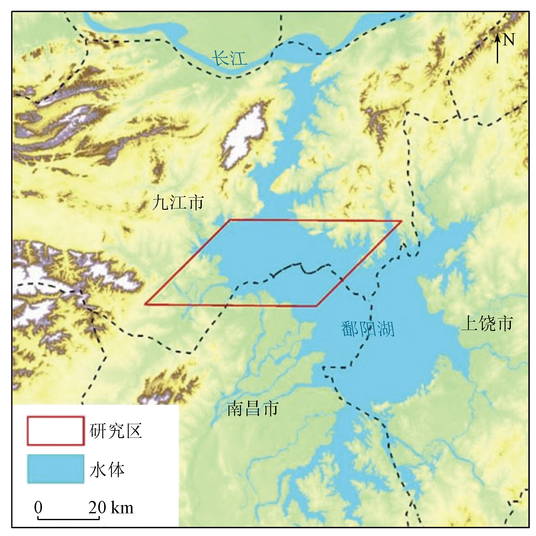
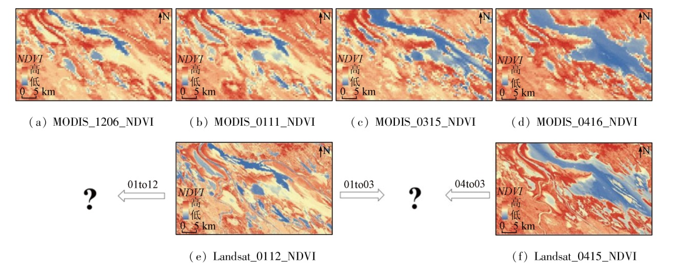
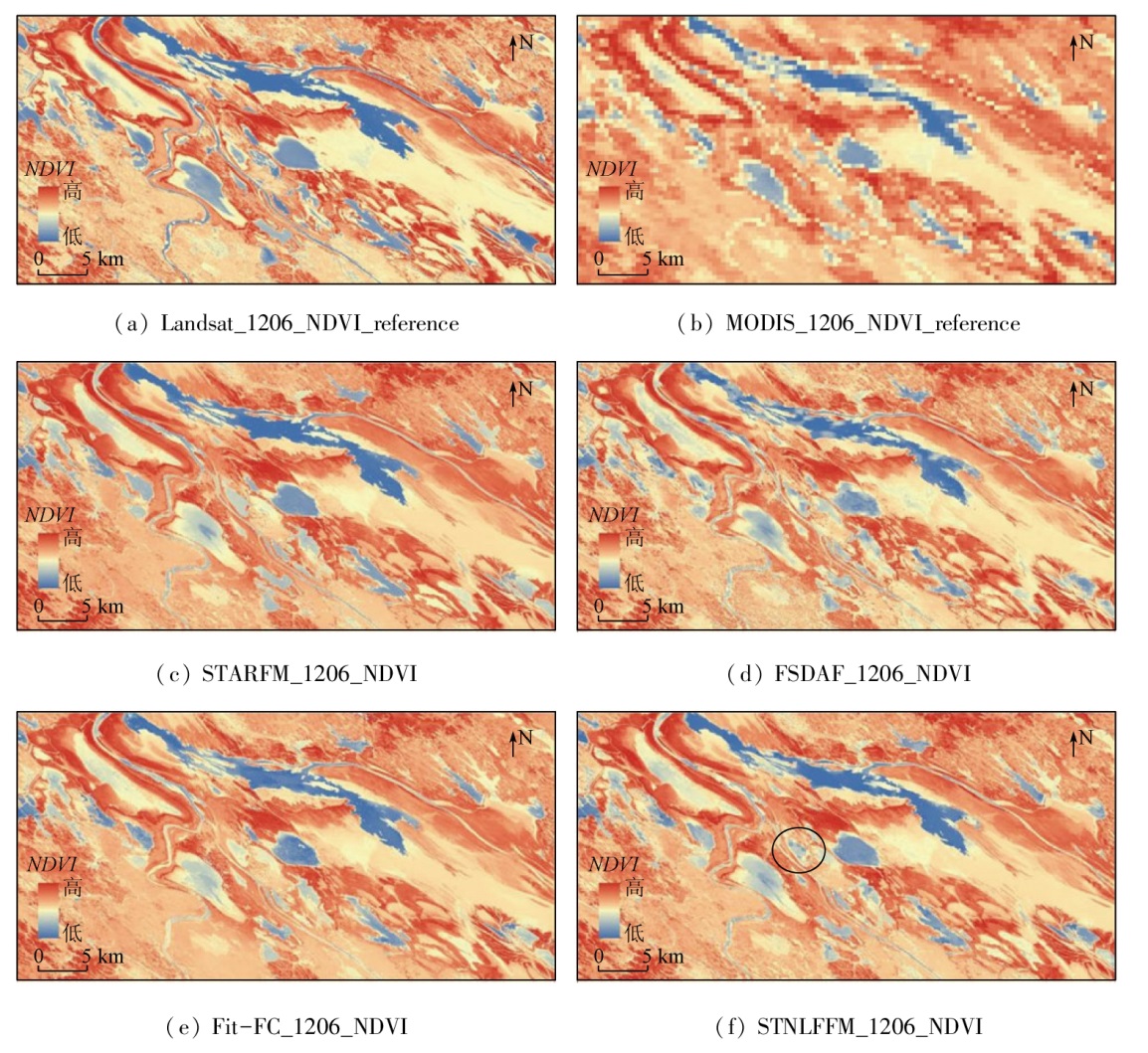
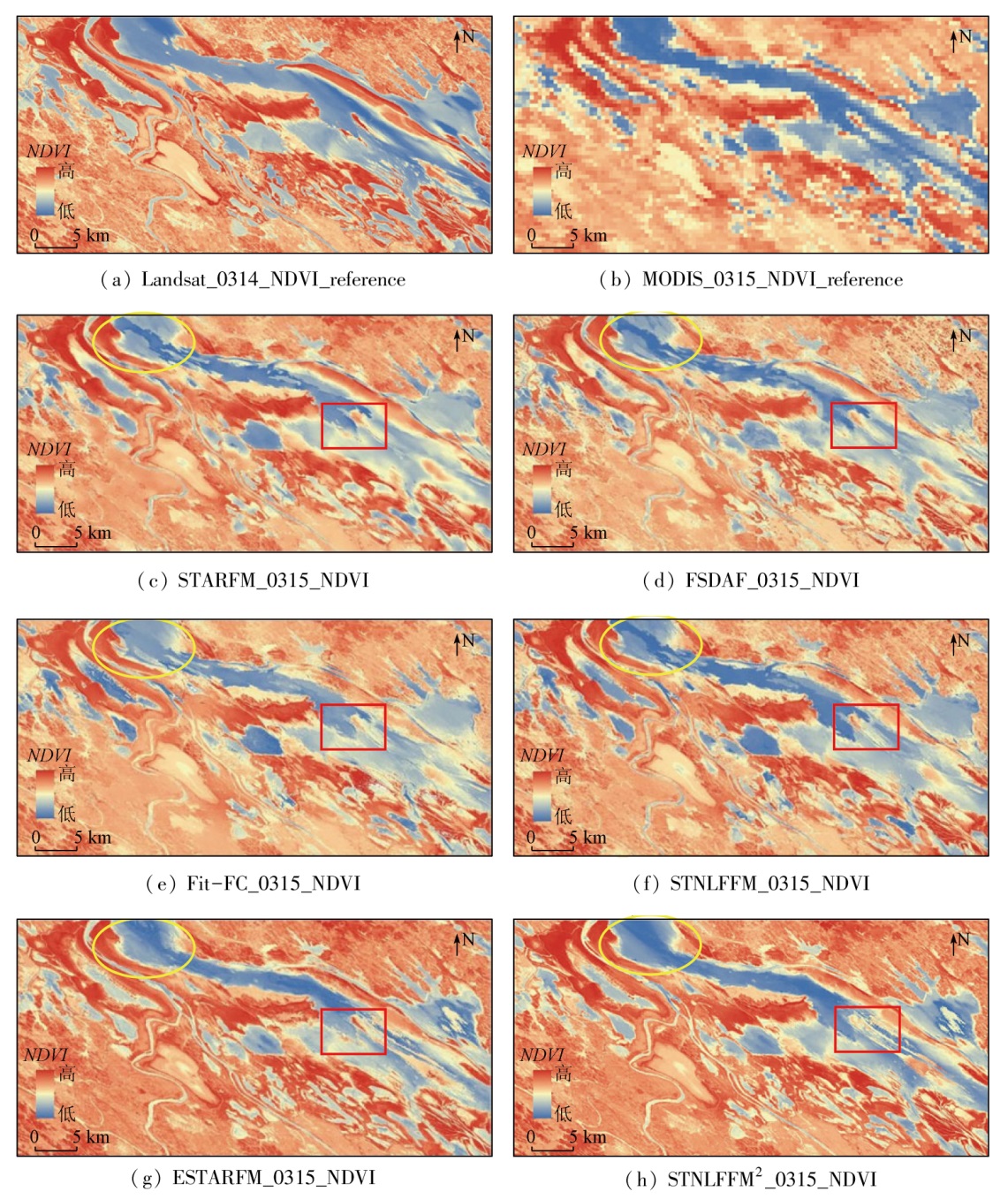
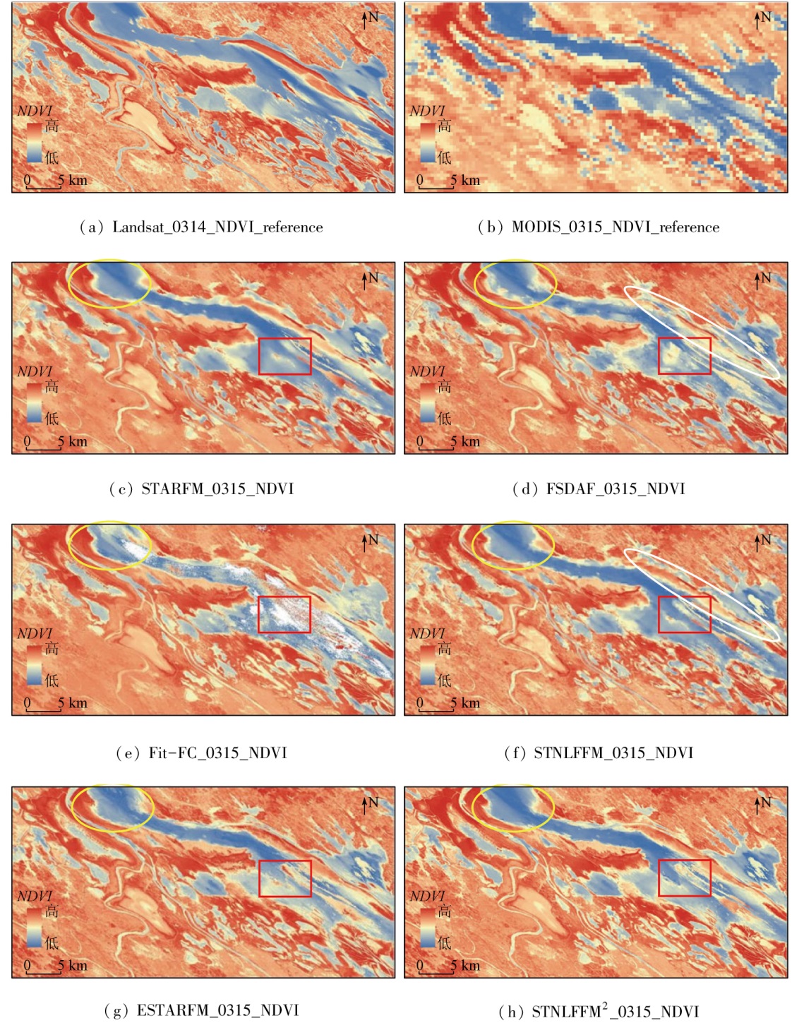
Abstract This study aims to explore the applicability of various spatio-temporal information fusion algorithms based on remote sensing data to wetland areas characterized by frequent land-water conversion and diverse surface features. With the Poyang Lake sample area as the study area, this study examined five typical spatio-temporal information fusion algorithms (STARFM, ESTARFM, FSDAF, Fit-FC, and STNLFFM). Considering the differences in surface features among different periods, Landsat and MODIS remote sensing data were selected to conduct image fusion experiments for normalized difference vegetation indices (NDVIs) during low- and normal-water periods. Moreover, the accuracy of these algorithms was evaluated in spatial and spectral dimensions. The results of this study are as follows: ① In the case of only one pair of coarse- and fine-resolution images as input, the FSDAF exhibited the optimal fusion prediction effect for the low-water period, with an overall error of 0.433 5, whereas the STNLFFM manifested the optimal fusion prediction effect for the normal-water period, with an overall error of 0.514 7; ② In the case of two pairs of coarse- and fine-resolution images of low- and normal-water periods as input, the ESTARFM demonstrated the optimal fusion prediction effect, with an overall error of 0.467 0; ③ The applicability of different algorithms to a wetland area is associated with the proportion of water bodies in the study area. The STNLFFM displayed the optimal fusion prediction effect for water bodies.
|
| Keywords
spatio-temporal information fusion
Poyang Lake wetland
FSDAF
STNLFFM
ESTARFM
|
|
|
|
Issue Date: 14 June 2024
|
|
|
| [1] |
张立福, 彭明媛, 孙雪剑, 等. 遥感数据融合研究进展与文献定量分析(1992—2018)[J]. 遥感学报, 2019, 23(4):603-619.
|
| [1] |
Zhang L F, Peng M Y, Sun X J, et al. Progress and bibliometric analysis of remote sensing data fusion method(1992—2018)[J]. Journal of Remote Sensing, 2019, 23(4):603-619.
|
| [2] |
Nunez J, Otazu X, Fors O, et al. Multiresolution-based image fusion with additive wavelet decomposition[J]. IEEE Transactions on Geoscience and Remote Sensing, 1999, 37(3):1204-1211.
|
| [3] |
Acerbi-Junior F W, Clevers J G P W, Schaepman M E. The assessment of multi-sensor image fusion using wavelet transforms for mapping the Brazilian Savanna[J]. International Journal of Applied Earth Observation and Geoinformation, 2006, 8(4):278-288.
|
| [4] |
Gao F, Masek J, Schwaller M, et al. On the blending of the Landsat and MODIS surface reflectance:Predicting daily Landsat surface reflectance[J]. IEEE Transactions on Geoscience and Remote Sensing, 2006, 44(8):2207-2218.
|
| [5] |
Zhu X L, Chen J, Gao F, et al. An enhanced spatial and temporal adaptive reflectance fusion model for complex heterogeneous regions[J]. Remote Sensing of Environment, 2010, 114(11):2610-2623.
|
| [6] |
Zhu X, Helmer E H, Gao F, et al. A flexible spatiotemporal method for fusing satellite images with different resolutions[J]. Remote Sensing of Environment, 2016, 172:165-177.
|
| [7] |
Wang Q M, Atkinson P M. Spatio-temporal fusion for daily Sentinel-2 images[J]. Remote Sensing of Environment, 2018, 204:31-42.
|
| [8] |
Cheng Q, Liu H, Shen H, et al. A spatial and temporal nonlocal filter-based data fusion method[J]. IEEE Transactions on Geoscience and Remote Sensing, 2017, 55(8):4476-4488.
|
| [9] |
Walker J J, de Beurs K M, Wynne R H, et al. Evaluation of Landsat and MODIS data fusion products for analysis of dryland forest phenology[J]. Remote Sensing of Environment, 2012, 117:381-393.
|
| [10] |
赵艳丽. 时空融合技术在高时空分辨率NDVI数据重构中的应用[D]. 太原: 太原理工大学, 2015.
|
| [10] |
Zhao Y L. Reconstruction of NDVI data with high-spatial and cemporal Vesolution using spatio-temporal fusion technique[D]. Taiyuan: Taiyuan University of Technology, 2015.
|
| [11] |
张伟, 李玮, 陶冠宏, 等. 利用STARFM模型提高复杂地表下复种指数遥感提取精度[J]. 农业工程学报, 2020, 36(21):175-185.
|
| [11] |
Zhang W, Li W, Tao G H, et al. Improvement of extraction accuracy for cropping intensity in complex surface regions using STARFM[J]. Journal of Agricultural Engineering, 2020, 36(21):175-185.
|
| [12] |
管琪卉, 丁明军, 张华, 等. ESTARFM算法在长江中下游平原地区的适用性研究[J]. 地球信息科学学报, 2021, 23(6):1118-1130.
doi: 10.12082/dqxxkx.2021.200404
|
| [12] |
Guan Q H, Ding M J, Zhang H, et al. Analysis of applicability about ESTARFM in the middle-lower Yangtze Plain[J]. Journal of Geo-Information Science, 2021, 23(6):1118-1130.
|
| [13] |
郝贵斌, 吴波, 张立福, 等. ESTARFM模型在西藏色林错湖面积时空变化中的应用分析(1976—2014年)[J]. 地球信息科学学报, 2016, 18(6):833-846.
doi: 10.3724/SP.J.1047.2016.00833
|
| [13] |
Hao G B, Wu B, Zhang L F, et al. Temporal and spatial variation analysis of the area of Siling Co Lake in Tibet based on ESTARFM(1976-2014)[J]. Journal of Geo-Information Science, 2016, 18(6):833-846.
|
| [14] |
程筱茜, 洪友堂, 陈劲松, 等. 基于ESTARFM的内陆湖泊水体遥感动态变化监测[J]. 国土资源遥感, 2020, 32(3):183-190.doi:10.6046/gtzyyg.2020.03.24.
|
| [14] |
Cheng X Q, Hong Y T, Chen J S, et al. A study of the long-term remote sensing dynamic monitoring of inland based on ESTARFM[J]. Remote Sensing for Land and Resources, 2020, 32(3):183-190.doi:10.6046/gtzyyg.2020.03.24.
|
| [15] |
Zhai H, Huang F, Qi H. Generating high resolution LAI based on a modified FSDAF model[J]. Remote Sensing, 2020, 12(1):150.
|
| [16] |
Guo D Z, Shi W Z, Hao M, et al. FSDAF 2.0:Improving the performance of retrieving land cover changes and preserving spatial details[J]. Remote Sensing of Environment, 2020, 248:111973.
|
| [17] |
Li X D, Foody G M, Boyd D S, et al. SFSDAF:An enhanced FSDAF that incorporates sub-pixel class fraction change information for spatio-temporal image fusion[J]. Remote Sensing of Environment, 2020, 237:111537.
|
| [18] |
Chen B, Huang B, Xu B. Comparison of spatiotemporal fusion models:A review[J]. Remote Sensing, 2015, 7(2):1798-1835.
|
| [19] |
谢诗怡, 况润元, 宋子豪. 鄱阳湖水域面积变化特征及对气象因素的响应[J]. 中国农村水利水电, 2022(7):103-109.
|
| [19] |
Xie S Y, Kuang R Y, Song Z H. Variation characteristics of water area Poyang Lake and its response to meteorological factors[J]. China Rural Water and Hydropower, 2022(7):103-109.
|
| [20] |
姚杰鹏, 杨磊库, 陈探, 等. 基于Sentinel-1,2和Landsat8时序影像的鄱阳湖湿地连续变化监测研究[J]. 遥感技术与应用, 2021, 36(4):760-776.
|
| [20] |
Yao J P, Yang L K, Chen T, et al. Consecutive monitoring of the Poyang Lake wetland by integrating Sentinel-2 with sentinel-1 and Landsat8 data[J]. Remote Sensing Technology and Application, 2021, 36(4):760-776.
|
| [21] |
许军, 王召滢, 唐山, 等. 鄱阳湖湿地植物多样性资源调查与分析[J]. 西北林学院学报, 2013, 28(3):93-97.
|
| [21] |
Xu J, Wang Z Y, Tang S, et al. Investigation and analysis of the resources of wetland plant diversity in Poyang lake[J]. Journal of Northwest Forestry University, 2013, 28(3):93-97.
|
| [22] |
沈陆平, 方朝阳, 肖昕, 等. 2021—2022年鄱阳湖10种珍稀候鸟定点观测数据集[J]. 中国科学数据(中英文网络版), 2022, 7(3):324-333.
|
| [22] |
Shen L P, Fang C Y, Xiao X, et al. A dataset of fixed-point observations of 10 rare migratory birds in Poyang Lake from 2021 to 2022[J]. China Scientific Data Chinese and English online version), 2022, 7(3):324-333.
|
| [23] |
Zhu X L, Zhan W F, Zhou J X, et al. A novel framework to assess all-round performances of spatiotemporal fusion models[J]. Remote Sensing of Environment, 2022, 274:113002.
|
| [24] |
Hu Y, Wang H, Niu X, et al. Comparative analysis and comprehensive trade-off of four spatiotemporal fusion models for NDVI generation[J]. Remote Sensing, 2022, 14(23):5996.
|
| [25] |
Emelyanova I V, McVicar T R, Van Niel T G, et al. Assessing the accuracy of blending Landsat-MODIS surface reflectances in two landscapes with contrasting spatial and temporal dynamics:A framework for algorithm selection[J]. Remote Sensing of Environment, 2013, 133:193-209.
|
| [26] |
Zhou J X, Chen J, Chen X H, et al. Sensitivity of six typical spatiotemporal fusion methods to different influential factors:A comparative study for a normalized difference vegetation index time series reconstruction[J]. Remote Sensing of Environment, 2021, 252:112130.
|
| [27] |
石晨烈, 王旭红, 张萌, 等. 3种时空融合算法在洪水监测中的适用性研究[J]. 国土资源遥感, 2020, 32(2):111-119.doi:10.6046/gtzyyg.2020.02.15.
|
| [27] |
Shi C L, Wang X H, Zhang M, et al. Analysis of the applicability of three remote sensing spatiotemporal fusion algorithms in flood monitoring[J]. Remote Sensing for Land and Resources, 2020, 32(2):111-119.doi:10.6046/gtzyyg.2020.02.15.
|
| [28] |
雷晨阳, 孟祥超, 邵枫. 遥感影像时—空融合的“点”—“线”—“面”质量评价[J]. 遥感学报, 2021, 25(3):791-802.
|
| [28] |
Lei C Y, Meng X C, Shao F. Spatio-temporal fusion quality evaluation based on “Point”-“Line”-“Plane” aspects[J]. National Remote Sensing Bulletin, 2021, 25(3):791-802.
|
|
Viewed |
|
|
|
Full text
|
|
|
|
|
Abstract
|
|
|
|
|
Cited |
|
|
|
|
| |
Shared |
|
|
|
|
| |
Discussed |
|
|
|
|
 2024,
Vol. 36
2024,
Vol. 36