|
|
|
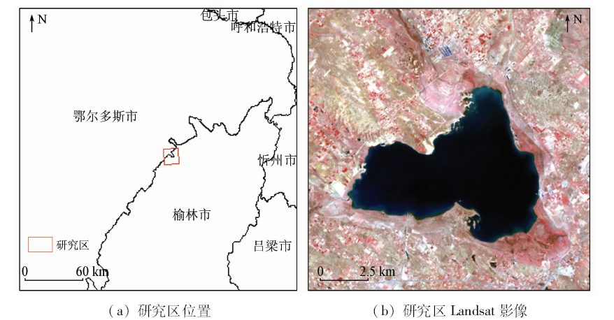
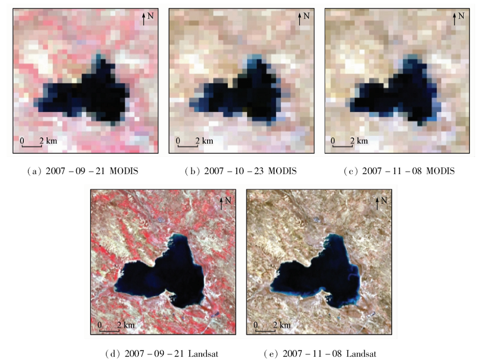
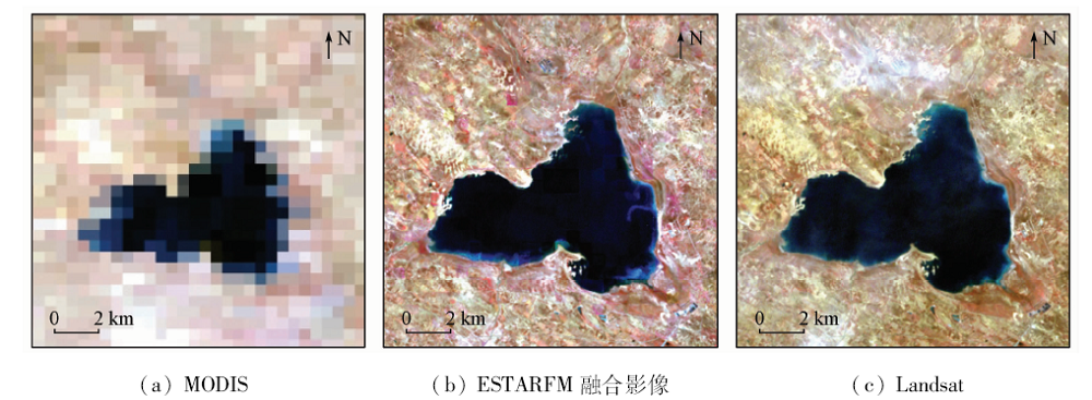
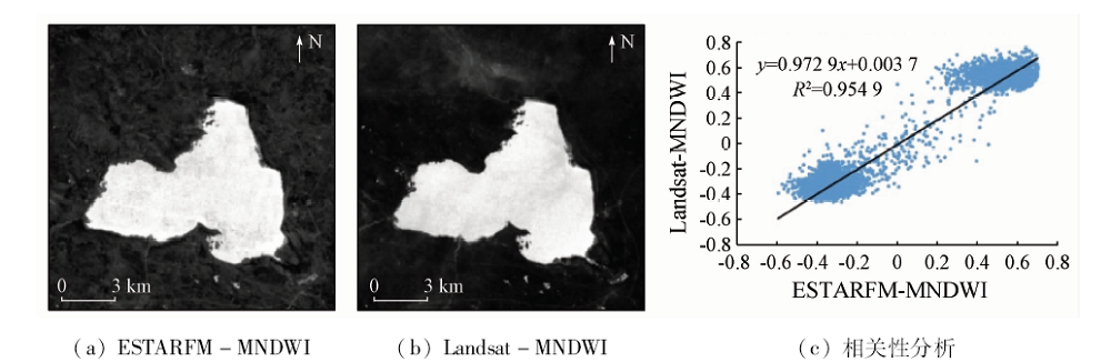
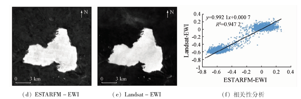
Abstract According to the fact that data missing problem often occurs during the study of long-term remote sensing dynamic monitoring of inland lake area, the authors tried to make up for the missing remote sensing images by utilizing the ESTARFM to combine with the MODIS data so as to simulate the missing Landsat images after 2000. On such a basis, the water index method was used to extract the lake area and shoreline so as to realize the long-term remote sensing dynamic monitoring of inland lake. Hongjiannao Lake in Inner Mongolia was selected as the study area. The method was tested by making up for the missing Landsat images from 1987 to 2018 with ESTARFM algorithm and extracting Hongjiannao Lake from all the images. Some conclusions have been reached: The MODIS and Landsat fusion images generated by the ESTARFM algorithm are ideal, which can effectively solve the problem of missing Landsat images after 2000. It is proved that the image obtained from the ESTARFM fusion can be applied to water extraction. In addition, time-series images with the fusion images are added to reflect the water changes more delicately when the water dynamic change is monitored, which contributes to the subsequent research. In addition, through the long-term remote sensing dynamic change monitoring of Hongjiannao, it is found that the lake changes generally show a shrinking stage, and the specifics can be divided into three stages: stability, sustained shrinkage and growth.
|
| Keywords
ESTARFM
inland lake
dynamic change
water index method
Hongjiannao Lake
|
|
|
|
Corresponding Authors:
HONG Youtang
E-mail: Chengxq_2018@163.com;hongyoutang@163.com
|
|
Issue Date: 09 October 2020
|
|
|
| [1] |
胡汝骥, 姜逢清, 王亚俊, 等. 论中国干旱区湖泊研究的重要意义[J].干旱区研究, 2007(2):137-140.
url: http://d.wanfangdata.com.cn/Periodical_ghqyj200702001.aspx
|
| [1] |
Hu R J, Jiang F Q, Wang Y J, et al. On the significance of lake research in arid regions of China[J].Arid Zone Research 2007(2):137-140.
|
| [2] |
马荣华, 杨桂山, 段洪涛, 等. 中国湖泊的数量、面积与空间分布[J]. 中国科学:地球科学, 2011,41(3):394-401.
|
| [2] |
Ma R H, Yang G S, Duan H T, et al. China’s lakes at present: Number,area and spatial distribution[J]. Scientia Sinica(Terrae), 2011,41(3):394-401.
|
| [3] |
胡安焱. 流域气候变化和人类活动对内陆湖泊影响的分析[J].干旱区资源与环境, 2007(5):1-5.
url: http://d.wanfangdata.com.cn/Periodical_ghqzyyhj200705001.aspx
|
| [3] |
Hu A Y. Analysis of the impacts of climate change and human activities on inland lakes[J].Journal of Arid Land Resources and Environment 2007(5):1-5.
url: http://d.wanfangdata.com.cn/Periodical_ghqzyyhj200705001.aspx
|
| [4] |
Pohl C, Van Genderen J L. Review article multisensor image fusion in remote sensing:Concepts,methods and applications[J]. International Journal of Remote Sensing, 1998,19(5):823-854.
doi: 10.1080/014311698215748
url: https://www.tandfonline.com/doi/full/10.1080/014311698215748
|
| [5] |
谢登峰, 张锦水, 潘耀忠, 等. Landsat8和MODIS融合构建高时空分辨率数据识别秋粮作物[J]. 遥感学报, 2015,19(5):791-805.
|
| [5] |
Xie D F, Zhang J S, Pan Y Z, et al. Fusion of MODIS and Landsat8 images to generate high spatial-temporal resolution data for mapping autumn crop distribution[J]. Journal of Remote Sensing, 2015,19(5):791-805.
|
| [6] |
刘咏梅, 马黎, 黄昌, 等. 基于MODIS-Landsat时空融合的陕北黄土高原植被覆盖变化研究[J].西北大学学报(自然科学版), 2019(1):62-70.
|
| [6] |
Liu Y M, Ma L, Huang C, et al. Study on the change of vegetation coverage of Loss Plateau in northern Shaanxi Province based on MODIS-Landsat fusion data[J].Journal of Northwest University(Natural Science Edition) 2019(1):62-70.
|
| [7] |
Jia K, Liang S L, Wei X Q, et al. Land cover classification of landsat data with phenological features extracted from time series MODIS NDVI data[J]. Remote Sensing, 2014,6(11):11518-11532.
doi: 10.3390/rs61111518
url: http://www.mdpi.com/2072-4292/6/11/11518
|
| [8] |
Zhu X L, Jin C, Feng G, et a1. An enhanced spatial and temporal adaptive reflectance fusion model for complex heterogeneous regions[J]. Remote Sensing of Environment, 2010,114(11):2610-2623.
doi: 10.1016/j.rse.2010.05.032
url: https://linkinghub.elsevier.com/retrieve/pii/S0034425710001884
|
| [9] |
Acerbi-Junior F W, Clevers J G P W, Schaepman M E. The assessment of multi-sensor image fusion using wavelet transforms for mapping the Brazilian Savanna[J]. International Journal of Applied Earth Observation and Geoinformation, 2006,8(4):278-288.
doi: 10.1016/j.jag.2006.01.001
url: https://linkinghub.elsevier.com/retrieve/pii/S0303243406000043
|
| [10] |
顾晓鹤, 韩立建, 王纪华, 等. 中低分辨率小波融合的玉米种植面积遥感估算[J]. 农业工程学报, 2012,28(3):203-209.
url: http://www.tcsae.org/nygcxb/ch/reader/view_abstract.aspx?file_no=20120335&flag=1
|
| [10] |
Gu X H, Han L J, Wang J H, et al. Estimation of maize planting area based on wavelet fusion of multi-resolution images[J]. Transactions of the Chinese Society of Agricultural Engineering, 2012,28(3):203-209.
url: http://www.tcsae.org/nygcxb/ch/reader/view_abstract.aspx?file_no=20120335&flag=1
|
| [11] |
Zhukov B, Oertel D, Lanzl F, et al. Unmixing-based multisensor multiresolution image fusion[J]. IEEE Transactions on Geoscience and Remote Sensing, 1999,37(3):1212-1226.
doi: 10.1109/36.763276
url: http://ieeexplore.ieee.org/document/763276/
|
| [12] |
Maselli F. Definition of spatially variable spectral endmembers by locally calibrated multivariate regression analyses[J]. Remote Sensing of Environment, 2001,75(1):29-38.
doi: 10.1016/S0034-4257(00)00153-X
url: https://linkinghub.elsevier.com/retrieve/pii/S003442570000153X
|
| [13] |
Busetto L, Meroni M, Colombo R. Combining medium and coarse spatial resolution satellite data to improve the estimation of sub-pixel NDVI time series[J]. Remote Sensing of Environment, 2008,112(1):118-131.
doi: 10.1016/j.rse.2007.04.004
url: https://linkinghub.elsevier.com/retrieve/pii/S0034425707001563
|
| [14] |
Gao F, Masek J, Schwaller M, et al. On the blending of the Landsat and MODIS surface reflectance:Predicting daily Landsat surface reflectance[J]. IEEE Transactions on Geoscience and Remote Sensing, 2006,44(8):2207-2218.
doi: 10.1109/TGRS.2006.872081
url: http://ieeexplore.ieee.org/document/1661809/
|
| [15] |
Mcfeeters S K. The use of the normalized difference water index (NDWI) in the delineation of open water features[J]. International Journal of Remote Sensing, 1996,17(7):1425-1432.
doi: 10.1080/01431169608948714
url: https://www.tandfonline.com/doi/full/10.1080/01431169608948714
|
| [16] |
徐涵秋. 利用改进的归一化差异水体指数(MNDWI)提取水体信息的研究[J]. 遥感学报, 2005,9(5):589-595.
doi: 10.11834/jrs.20050586
url: http://www.jors.cn/jrs/ch/reader/view_abstract.aspx?file_no=20050586&flag=1
|
| [16] |
Xu H Q. A study on information extraction of waterbody with the modified normalized difference water index(MNDWI)[J]. Journal of Remote Sensing, 2005,9(5):589-595.
doi: 10.11834/jrs.20050586
url: http://www.jors.cn/jrs/ch/reader/view_abstract.aspx?file_no=20050586&flag=1
|
| [17] |
Yan P, Zhang Y J, Zhang Y. A study on information extraction of water system in semi-arid regions with the enhanced water index(EWI) and GIS based noise remove techniques[J].Remote Sensing Information, 2007(6):62-67.
url: http://d.wanfangdata.com.cn/Periodical_ygxx200706015.aspx
|
| [18] |
李登科, 何慧娟, 刘安麟. 人类活动和气候变化对红碱淖植被覆盖变化的影响[J]. 中国沙漠, 2010,30(4):831-836.
url: http://zgsm.westgis.ac.cn/CN/abstract/abstract1407.shtml
|
| [18] |
Li D K, He H J, Liu A L. Effects of human activities and climate change on vegetation cover change of Hongjiannao[J]. Journal of Desert Research, 2010,30(4):831-836.
url: http://zgsm.westgis.ac.cn/CN/abstract/abstract1407.shtml
|
| [19] |
唐克旺, 王浩, 刘畅. 陕北红碱淖湖泊变化和生态需水初步研究[J].自然资源学报, 2003(3):304-309.
doi: 10.11849/zrzyxb.2003.03.007
url: http://www.jnr.ac.cn/CN/abstract/abstract1586.shtml
|
| [19] |
Tang K W, Wang H, Liu C. Preliminary study on lake change and ecological water demand in Hongjiannao,northern Shaanxi Province[J].Journal of Natural Resources 2003(3):304-309.
doi: 10.11849/zrzyxb.2003.03.007
url: http://www.jnr.ac.cn/CN/abstract/abstract1586.shtml
|
| [20] |
李登科, 卓静, 王钊. 人类活动和气候变化对红碱淖水面面积的影响[J]. 冰川冻土, 2009,31(6):1110-1115.
url: http://bcdt.westgis.ac.cn/CN/abstract/abstract211.shtml
|
| [20] |
Li D K, Zhuo J, Wang Z. Effect of human activities and climate change on the water surface area of Hongjiannao[J]. Journal of Glaciology and Geocryology, 2009,31(6):1110-1115.
url: http://bcdt.westgis.ac.cn/CN/abstract/abstract211.shtml
|
| [21] |
杨立彬, 黄强, 武见, 等. 红碱淖湖泊面积变化影响因素及预测分析[J]. 干旱区资源与环境, 2014,28(3):74-78.
|
| [21] |
Yang L B, Huang Q, Wu J, et al. Influencing factors and prediction analysis of lake area change of Hongjiannao[J]. Journal of Arid Land Resources and Environment, 2014,28(3):74-78.
|
|
Viewed |
|
|
|
Full text
|
|
|
|
|
Abstract
|
|
|
|
|
Cited |
|
|
|
|
| |
Shared |
|
|
|
|
| |
Discussed |
|
|
|
|
 2020,
Vol. 32
2020,
Vol. 32
 ), HONG Youtang(