|
|
 |
|

|
|
|
Analysis and application of spatiotemporal variation in sea surface temperature in the Taiwan Strait based on Himawari-8 data |
ZHANG Chungui1,2( ), WU Zuohang1,2, WANG Jing3, CHEN Wenjia4 ), WU Zuohang1,2, WANG Jing3, CHEN Wenjia4 |
1. Fujian Institute of Meteorological Sciences, Fuzhou 350008, China
2. Fujian Key Laboratory of Severe Weather, Fuzhou 350008, China
3. Fujian Meteorological Information Center, Fuzhou 350008, China
4. Xiapu Meteorological Bureau, Ningde 355100, China |
|
|
|
|
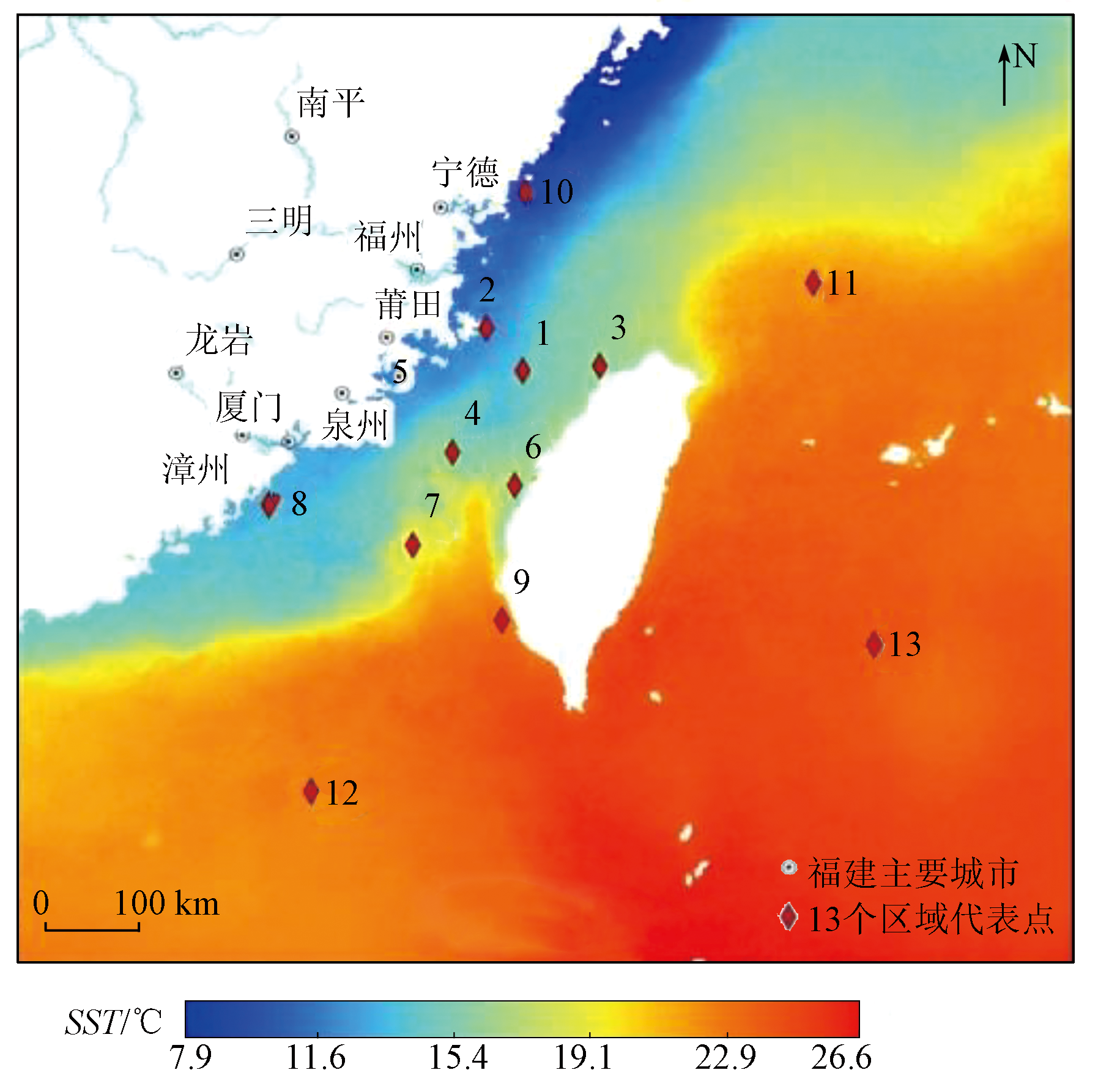
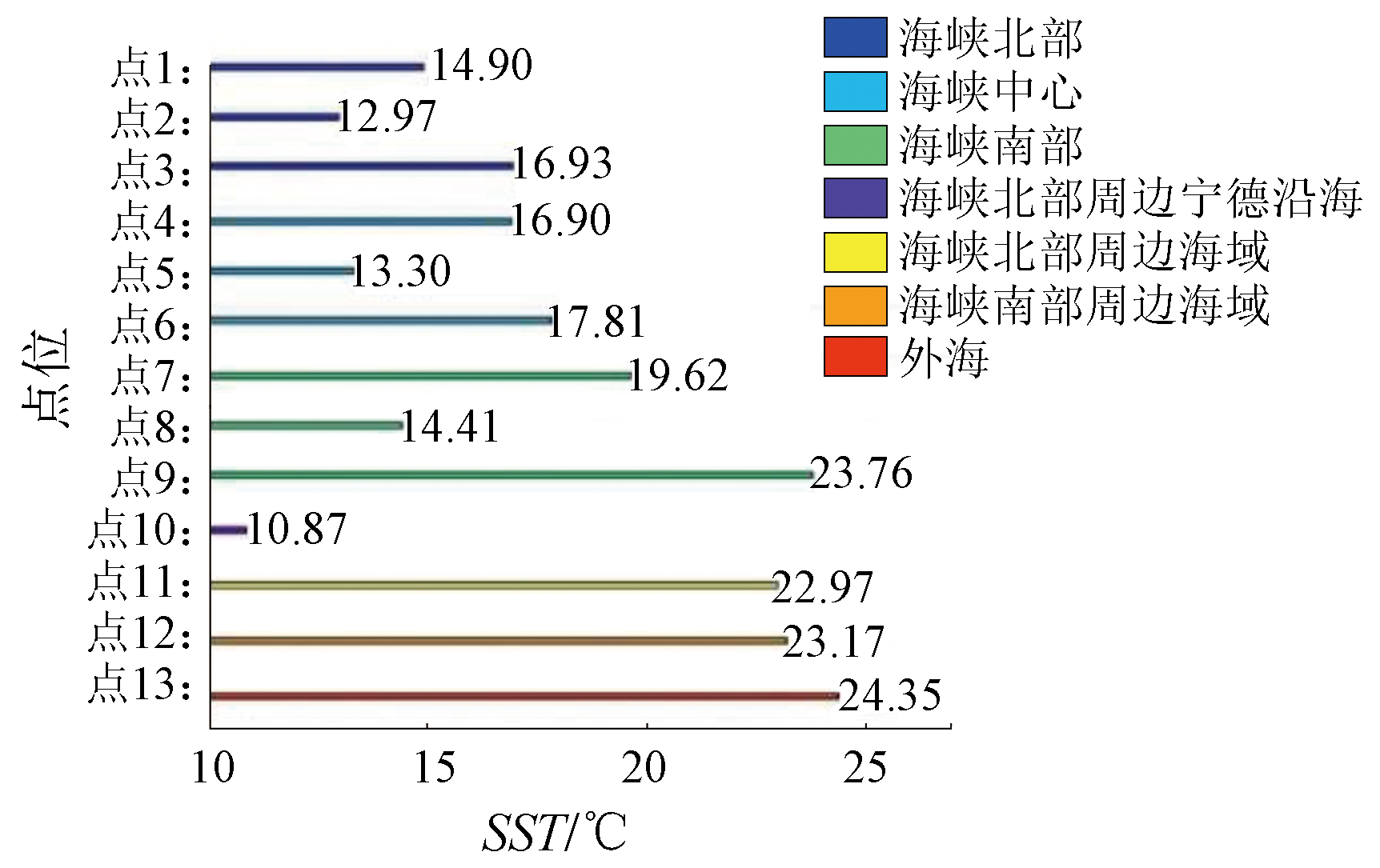
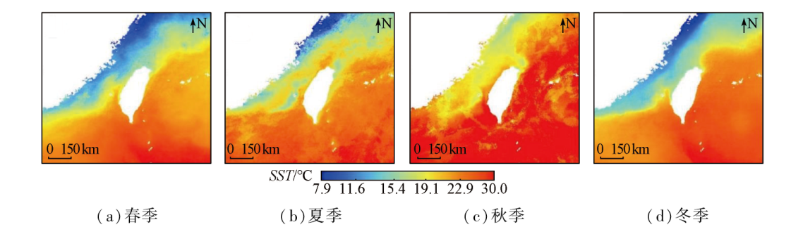
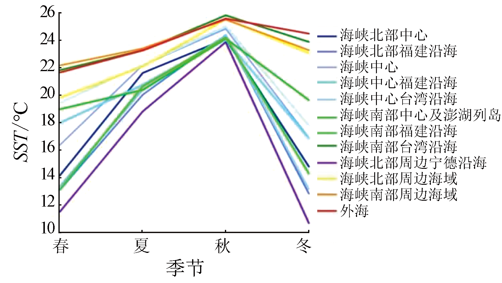
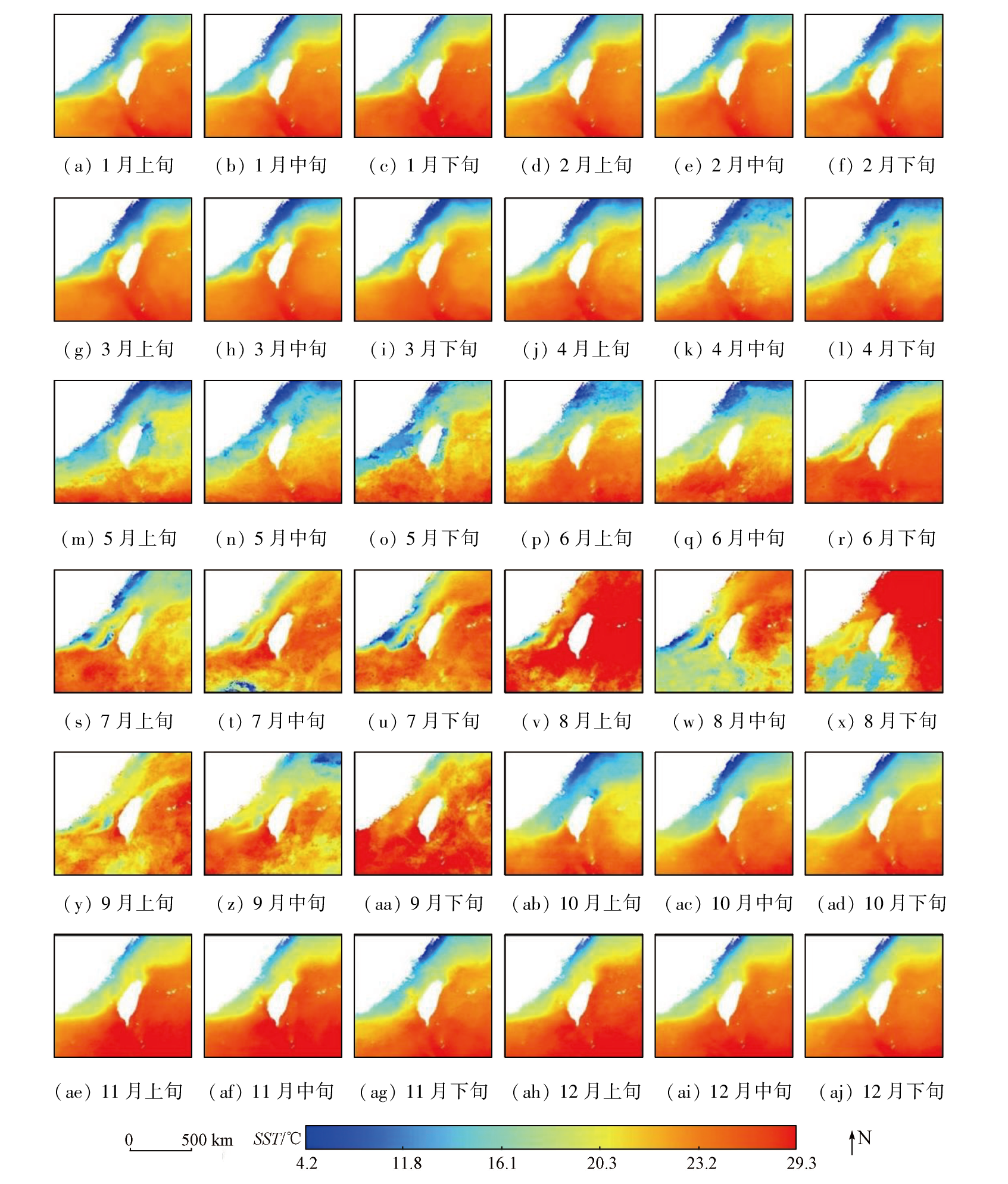
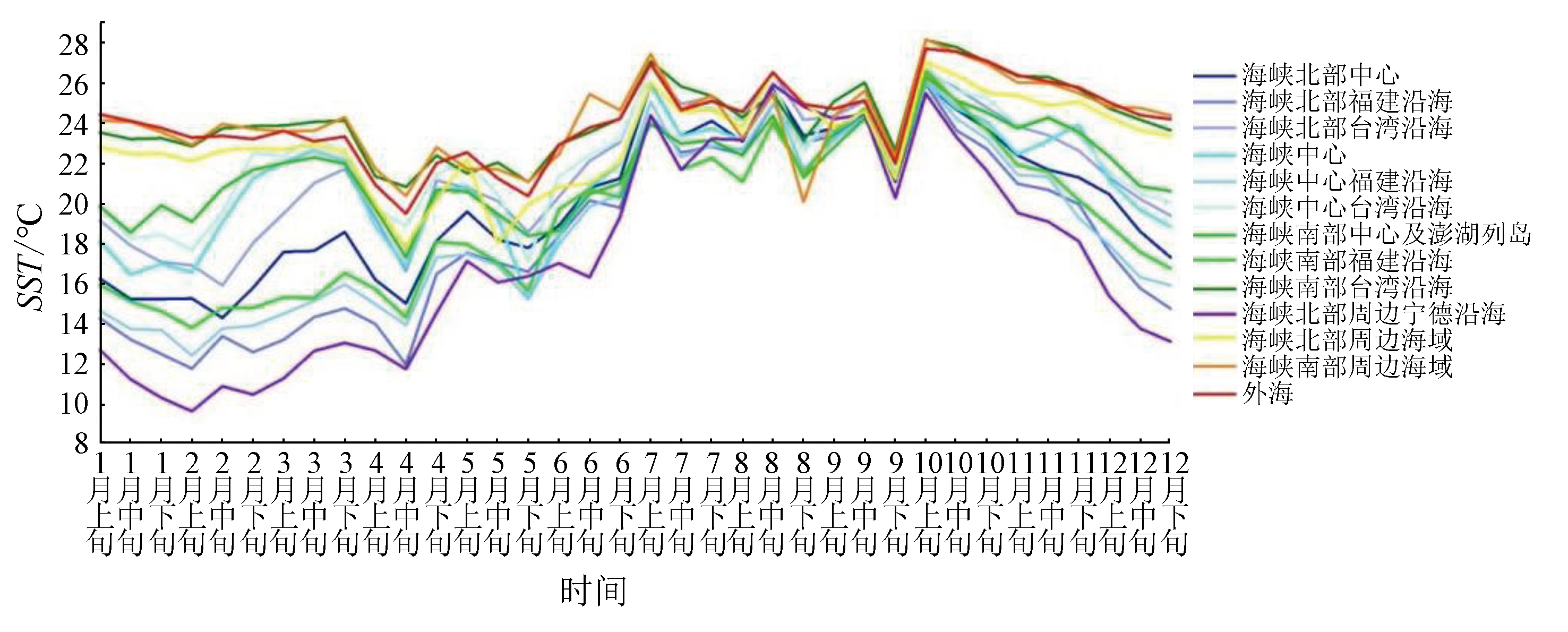
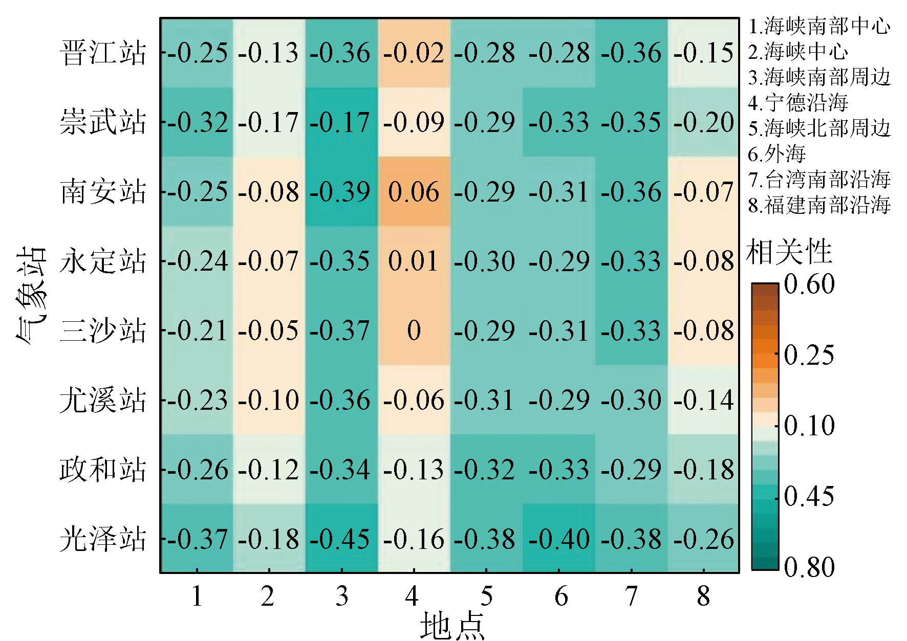
Abstract The Taiwan Strait holds a significant strategic position and great value for research. Investigating the spatiotemporal variations in sea surface temperature (SST) in the Taiwan Strait and its surrounding sea areas helps enhance the understanding of the marine-continental environmental interactions and changes in ocean currents in this region. Such investigation is particularly significant for comprehensively understanding the complex marine frontal systems within the Taiwan Strait. This study investigated the Taiwan Strait and its surrounding sea areas. Using 2016—2020 Himawari-8 satellite data, this study determined the annual, seasonal, and ten-day averages of SST remote sensing data. Based on these data, this study examined spatiotemporal variations in the SST and, accordingly, explored correlations between SST and inland precipitation and coastal fog in Fujian. The results indicate that the annual mean SST in the Taiwan Strait and surrounding sea areas exhibited a zonal distribution, increasing gradually from northwest to southeast. Seasonally, the SST exhibited two distribution patterns: a winter pattern, with isotherms approximately parallel to the coast, and a summer pattern, with isotherms more uniformly distributed. The ten-day SST data allowed for more fine-scale characterization of the spatiotemporal variations in the SST of the Taiwan Strait. The inland monthly precipitation generally exhibited a weak negative correlation with monthly mean SST, with this correlation strengthening with an increase in the distance from open sea areas. Additionally, a strong negative correlation was observed between the SST and coastal fog, with the coastal fog occurrence number trending downward with increasing SST.
|
| Keywords
Taiwan Strait
SST spatiotemporal variation
Himawari-8
sea fog
|
|
|
|
Issue Date: 23 December 2024
|
|
|
| [1] |
章梦娟. 1871—2010年南海及毗邻西太海域表层海温的时空分布及差异特征[D]. 上海: 上海师范大学, 2021.
|
| [1] |
Zhang M J. Temporal and spatial distribution and differences of surface temperature in the south China sea and the adjacent west Pacific Ocean from 1871 to 2010[D]. Shanghai: Shanghai Normal University, 2021.
|
| [2] |
赵鹤, 颉卫华, 吴统文, 等. 影响春季热带太平洋地区海温变化的动力热力作用分析[J]. 大气科学, 2020, 44(3):519-532.
|
| [2] |
Zhao H, Jie W H, Wu T W, et al. Analysis of the influence of dynamic and thermal effects on sea temperature in the tropical Pacific Ocean during spring[J]. Chinese Journal of Atmospheric Sciences, 2020, 44(3):519-532.
|
| [3] |
McPhaden M J, Hayes S P. On the variability of winds,sea surface temperature,and surface layer heat content in the western equatorial Pacific[J]. Journal of Geophysical Research:Oceans, 1991, 96(s1):3331-3342.
|
| [4] |
Springer S R, McPhaden M J, Busalacchi A J. Oceanic heat content variability in the tropical Pacific during the 1982-1983 El Niño[J]. Journal of Geophysical Research:Oceans, 1990, 95(c12):22089-22101.
|
| [5] |
易香妤, 董文杰, 李劭怡, 等. 中国东海黑潮海温变化特征及成因分析[J]. 海洋预报, 2021, 38(3):38-51.
|
| [5] |
Yi X Y, Dong W J, Li S Y, et al. The characteristics of sea temperature variation in the Kuroshio area in the East China Sea and its causes[J]. Marine Forecasts, 2021, 38(3):38-51.
|
| [6] |
许金镜. 西太平洋赤道附近海温与中国东南沿海台风关系的初步分析[J]. 台湾海峡, 1998, 17(3):278-281.
|
| [6] |
Xu J J. Primary analysis of relation between SST of West-Pacific near Equator and typhoon along southeast China[J]. Journal of Oceanography in Taiwan Strait, 1998, 17(3):278-281.
|
| [7] |
徐振宸. 北半球陆地降水的年代际变率及其与海表温度的联系[D]. 南京: 南京信息工程大学, 2020.
|
| [7] |
Xu Z C. Decadal variability of land precipitation in northern hemisphere and its relationship with the sea surface temperature[D]. Nanjing: Nanjing University of Information Science and Technology, 2020.
|
| [8] |
刘泽. 中国近海锋面时空特征研究及现场观测分析[D]. 青岛: 中国科学院研究生院(海洋研究所), 2012.
|
| [8] |
Liu Z. The spatio-temporal variability of oceanic fronts offshore China seas and analysis of marine observations[D]. Qingdao: Institute of Oceanology,Chinese Academy of Sciences, 2012.
|
| [9] |
张学敏, 商少平, 张彩云, 等. 闽南—台湾浅滩渔场海表温度对鲐鲹鱼类群聚资源年际变动的影响初探[J]. 海洋通报, 2005(4):91-96.
|
| [9] |
Zhang X M, Shang S P, Zhang C Y, et al. Potential influence of sea surface temperature on the interannual fluctuation of the catch and the distribution of chub macherel and round scad in the Minnan-Taiwan bank fishing ground,China[J]. Marine Science Bulletin, 2005(4):91-96.
|
| [10] |
张秀芝, 裘越芳, 吴迅英. 近百年中国近海海温变化[J]. 气候与环境研究, 2005(4):799-807.
|
| [10] |
Zhang X Z, Qiu Y F, Wu X Y. The long-term change for sea surface temperature in the last 100 years in the offshore sea of China[J]. Climatic and Environmental Research, 2005(4):799-807.
|
| [11] |
鲍家勇, 赵月旭. 基于Floyd算法的海温时间序列分割[J]. 数理统计与管理, 2019, 38(2):326-333.
|
| [11] |
Bao J Y, Zhao Y X. Sea surface temperature time series segmentation based on Floyd algorithm[J]. Journal of Applied Statistics and Management, 2019, 38(2):326-333.
|
| [12] |
王平, 毛克彪, 孟飞, 等. 中国东海海表温度时空演化分析[J]. 国土资源遥感, 2020, 32(4):227-235.doi:10.6046/gtzyyg.2020.04.28.
|
| [12] |
Wang P, Mao K B, Meng F, et al. Spatiotemporal evolution of sea surface temperature in the East China Sea[J]. Remote Sensing for Land and Resources, 2020, 32(4):227-235.doi:10.6046/gtzyyg.2020.04.28.
|
| [13] |
龙上敏, 刘秦玉, 郑小童, 等. 南大洋海温长期变化研究进展[J]. 地球科学进展, 2020, 35(9):962-977.
doi: 10.11867/j.issn.1001-8166.2020.076
|
| [13] |
Long S M, Liu Q Y, Zheng X T, et al. Research progress of long-term ocean temperature changes in the southern ocean[J]. Advances in Earth Science, 2020, 35(9):962-977.
doi: 10.11867/j.issn.1001-8166.2020.076
|
| [14] |
李扬, 陈权亮, 蔡宏珂, 等. 全球变暖背景下热带太平洋海温长期趋势研究[J]. 气候与环境研究, 2019, 24(6):723-734.
|
| [14] |
Li Y, Chen Q L, Cai H K, et al. Long term trend of tropical Pacific temperature under global warming[J]. Climatic and Environmental Research, 2019, 24(6):723-734.
|
| [15] |
卢静荣, 张济世. 海陆温差指数与我国华北地区降水的相关性分析[J]. 人民长江, 2018, 49(19):46-52.
|
| [15] |
Lu J R, Zhang J S. Correlation analysis between sea-land temperature difference index and precipitation in North China[J]. Yangtze River, 2018, 49(19):46-52.
|
| [16] |
Wang D X, Liu Q Y, Xie Q, et al. Progress of regional oceanography study associated with western boundary current in the South China Sea[J]. Chinese Science Bulletin, 2013, 58(11):1205-1215.
|
| [17] |
Hung R H, Gu L, Zhou L T, et al. Impact of the thermal state of the tropical Western Pacific on onset date and process of the South China Sea summer monsoon[J]. Advances in Atmospheric Sciences, 2006, 23(6) :909-924.
|
| [18] |
徐保梁. 全球及区域陆地降水的多时间尺度变化特征及其与海温的联系[D]. 北京: 中国科学院大学(大气物理研究所), 2016.
|
| [18] |
Xu B L. Multi-timescale variation characteristics of global and regional precipitation and their relationship with Sea Surface[D]. Beijing: Institute of Atmospheric Physics,Chinese Academy of Sciences, 2016.
|
| [19] |
Mohino E, Janicot S, Badar J. Sahel rainfall and decadal to multi-decadal sea surface temperature variability[J]. Climate Dynamics, 2011, 37(3):419-440.
|
| [20] |
Giannini A, Saravanan R, Chang P. Oceanic forcing of Sahel rainfall on interannual to interdecadal time scales[J]. Science, 2003, 302(5647):1027-1030.
pmid: 14551320
|
| [21] |
外力·吾甫尔, 严佩文, 黄丹青. 华南地区秋季无降水日的变化特征及其与海温的联系[J]. 热带气象学报, 2020, 36(1):108-114.
|
| [21] |
Wufuer W L, Yan P W, Huang D Q. Features of the autumn non-rainfall frequency over South China and the associated ocean conditions[J]. Journal of Tropical Meteorology, 2020, 36(1):108-114.
|
| [22] |
Hoerling M, Eischeid J, Perlwitz J, et al. Characterizing recent trends in U.S.heavy precipitation[J]. Journal of Climate, 2016, 29(7):2313-2332.
|
| [23] |
相士堂. 黄海北部海温与海雾的关系及海雾长期预报[J]. 海洋通报, 1985, 4(3):13-18.
|
| [23] |
Xiang S T. Relationship between the sea-condition and the sea fog,and the corresponding long-range forecast of sea fog in the northern Yellow Sea[J]. Marine Science Bulletin, 1985, 4(3):13-18.
|
| [24] |
黄惠镕, 韩美, 潘宁, 等. 福建一次春季海雾的边界层特征及其成因分析[J]. 海峡科学, 2019(3):12-15,25.
|
| [24] |
Huang H R, Han M, Pan N, et al. Characteristics of the boundary layer of a spring sea fog in Fujian and its cause analysis[J]. Straits Science, 2019(3):12-15,25.
|
| [25] |
Huang H J, Liu H N, Huang J, et al. Atmospheric boundary layer structure and turbulence during sea fog on the southern China coast[J]. Monthly Weather Review, 2015, 143(5):1907-1923.
|
| [26] |
战淑芸, 林玉英. 华南沿海海雾的气候特征及其与赤道东太平洋海温的关系[J]. 海洋预报, 1988, 5(1):23-32.
|
| [26] |
Zhan S Y, Lin Y Y. Climatic features of the sea fog along the South China coast and its relation to the eastern equatorial Pacific SST[J], Marine Forecasts, 1988, 5(1):23-32.
|
| [27] |
张伟, 陈德花, 胡雅君, 等. 闽南沿海一次春季海雾过程微物理特征分析[J]. 气象, 2021, 47(2):157-169.
|
| [27] |
Zhang W, Chen D H, Hu Y J, et al. Microphysical structure analysis of a spring sea fog event in southern coastal area of Fujian[J]. Meteorological Monthly, 2021, 47(2):157-169.
|
| [28] |
张春桂. 福建省近海区域海面表层温度的卫星遥感应用研究[J]. 国土资源遥感, 1999(1):29-32.doi:10.6046/gtzyyg.1999.01.06.
|
| [28] |
Zhang C G. Study on the utilization of satellite remote sensing for sea surface temperature of coastal area in Fujian province[J]. Remote Sensing for Land and Resources, 1999(1):29-32.doi:10.6046/gtzyyg.1999.01.06.
|
| [29] |
刘百桥, 王华, 王宏. 用AVHRR资料计算月平均海水表层温度场[J]. 海洋通报, 1995, 14(6):24-28.
|
| [29] |
Liu B Q, Wang H, Wang H. Calculation of monthly mean sea surface layer temperature field with AVHRR data[J]. Marine Science Bulletin, 1995, 14(6):24-28.
|
| [30] |
孙凤琴, 张彩云, 商少平, 等. 西北太平洋部分海域AVHRR、TMI与MODIS遥感海表层温度的初步验证[J]. 厦门大学学报(自然科学版), 2007, 46(s1):1-5.
|
| [30] |
Sun F Q, Zhang C Y, Shang S P, et al. Primary validation of AVHRR/MODIS/TMI SST for part of the Northwest Pacific[J]. Journal of Xiamen University(Natural Science), 2007, 46(s1):1-5.
|
| [31] |
王其茂, 林明森, 郭茂华. HY-1卫星海温反演的误差分析[J]. 海洋科学进展, 2006, 24(3):355-359.
|
| [31] |
Wang Q M, Lin M S, Guo M H. Error analysis of sea surface temperature retrieved from the HY-1 satellite data[J]. Advances in Marine Science, 2006, 24(3):355-359.
|
| [32] |
方立新, 陈戈, 方朝阳, 等. 基于AVHRR/SST的西太平洋暖池近期变化研究[J]. 中国海洋大学学报(自然科学版), 2004(1):103-108.
|
| [32] |
Fang L X, Chen G, Fang C Y, et al. An investigation of recent western pacific warm pool variabilities based on AVHRR/SST[J]. Periodical of Ocean University of China, 2004(1):103-108.
|
| [33] |
陈子通. 静止气象卫星反演海温及其分析技术方法的研究[J]. 热带气象学报, 2001, 17(3):235-241.
|
| [33] |
Chen Z T. Study on SST with GMS observation and the method of analysis technique[J]. Journal of Tropical Meteorology, 2001, 17(3):235-241.
|
| [34] |
张春桂, 张星, 曾银东, 等. 台湾海峡海表面温度的遥感反演及精度检验[J]. 海洋学报, 2008, 30(2):153-160.
|
| [34] |
Zhang C G, Zhang X, Zeng Y D, et al. Retrieval and validation of sea surface temperature in the Taiwan Strait using MODIS data[J] Acta Oceanologica Sinica, 2008, 30(2):153-160.
|
| [35] |
王素娟, 崔鹏, 张鹏, 等. FY-3卫星VIRR海表温度产品进展[J]. 上海航天, 2017, 34(4):79-84.
|
| [35] |
Wang S J, Cui P, Zhang P, et al. Progress of VIRR sea surface temperature product of FY-3 satellite[J]. Aerospace Shanghai, 2017, 34(4):79-84.
|
| [36] |
廖志宏. FY-3C卫星数据的海表温度融合与重构研究[D]. 北京: 中国科学院大学(中国科学院遥感与数字地球研究所), 2017.
|
| [36] |
Liao Z H. Sea surface temperature reconstruction for FY-3C satellite data[D]. Beijing: Institute of Remote Sensing and Digital Earth,Chinese Academy of Sciences, 2017.
|
| [37] |
段广拓, 陈劲松, 张彦南, 等. 基于Landsat8卫星热红外影像反演珠江口海表温度[J]. 应用海洋学学报, 2018, 37(3):348-355.
|
| [37] |
Duan G T, Chen J S, Zhang Y N, et al. SST retrieving of the Pearl River Estuary by thermal infrared images from Landsat8 satellite[J]. Journal of Applied Oceanography, 2018, 37(3):348-355.
|
| [38] |
于杰, 李永振, 陈丕茂, 等. 利用Landsat TM6数据反演大亚湾海水表层温度[J]. 国土资源遥感, 2009, 21(3):24-29.doi:10.6046/gtzyyg.2009.03.05.
|
| [38] |
Yu J, Li Y Z, Chen P M, et al. SST retrieving of DAYA Bay from Landsat TM6[J]. remote sensing for land and resources, 2009, 21(3):24-29.doi:10.6046/gtzyyg.2009.03.05.
|
| [39] |
王洁, 王杰, 许佳峰, 等. 长江口邻近海域海表温度变化特征分析[J]. 海洋科学进展, 2020, 38(4):624-634.
|
| [39] |
Wang J, Wang J, Xu J F, et al. Characteristics of the sea surface temperature variation in adjacent area of the Yangtze River Estuary[J]. Advances in Marine Science, 2020, 38(4):624-634.
|
| [40] |
张雷, 任国玉, 宝乐尔其木格, 等. 基于卫星观测的南海表层温度气候学特征及长期变化[J]. 气候变化研究进展, 2017, 13(3):189-197.
|
| [40] |
Zhang L, Ren G Y, Baoleerqimuge, et al. Climatology and change of the South China sea surface temperature based on satellite observations[J]. Climate Change Research, 2017, 13(3):189-197.
|
| [41] |
贾丹丹, 陈正华, 张威, 等. 南海珊瑚礁区34年卫星遥感海表温度变化的时空特征分析[J]. 海洋学报, 2018, 40(3):112-120.
|
| [41] |
Jia D D, Chen Z H, Zhang W, et al. Analysis of temporal and spatial characteristics of sea surface temperature variations over the past 34 years in coral reef areas of the South China Sea[J]. Haiyang Xuebao, 2018, 40(3):112-120.
|
| [42] |
郑贵洲, 熊良超, 廖艳雯, 等. 利用MODIS数据反演南海南部海表温度及时空变化分析[J]. 遥感技术与应用, 2020, 35(1):132-140.
doi: 10.11873/j.issn.1004-0323.2020.1.0132
|
| [42] |
Zheng G Z, Xiong L C, Liao Y W, et al. Sea surface temperature inversion of the Southern South China Sea from MODIS and temporal and spatial variation analysis[J]. Remote Sensing Technology and Application, 2020, 35(1):132-140.
|
| [43] |
李恺霖, 张春桂, 王宏, 等. 基于葵花-8卫星的东南沿海气溶胶时空分布及其变化[J]. 应用海洋学学报, 2019, 38(3):318-328.
|
| [43] |
Li K L, Zhang C G, Wang H, et al. Spatial and temporal distribution and variation of aerosol optical depth in coastal southeast China based on Himawari-8 satellite[J]. Journal of Applied Oceanography, 2019, 38(3):318-328.
|
| [44] |
周旋, 叶小敏, 周江涛, 等. 基于Himawari-8卫星的逐时次海表温度融合[J]. 海洋学报, 2021, 43(1):137-146.
|
| [44] |
Zhou X, Ye X M, Zhou J T, et al. Hourly sea surface temperature fusion based on Himawari-8 satellite[J]. Haiyang Xuebao, 2021, 43(1):137-146.
|
| [45] |
胡毅, 陈坚, 许江. 台湾海峡的海洋沉积环境研究进展[J]. 海洋通报, 2011, 30(5):595-600.
|
| [45] |
Hu Y, Chen J, Xu J. Progress in the marine sedimentary environment research for the Taiwan Strait[J]. Marine Science Bulletin, 2011, 30(5):595-600.
|
| [46] |
黄韦艮, 林传兰, 楼琇林, 等. 台湾海峡及其邻近海域海面温度锋的卫星遥感观测[J]. 海洋学报, 2006, 28(4):49-55.
|
| [46] |
Huang W G, Lin C L, Lou X L, et al. Satellite observations of the thermal front in the Taiwan Strait and its adjacent seas[J]. Haiyang Xuebao, 2006, 28(4):49-55.
|
| [47] |
Kurihara Y, Murakami H, Kachi M. Sea surface temperature from the new Japanese geostationary meteorological Himawari-8 satellite[J]. Geophysical Research Letters, 2016, 43(3):1234-1240.
|
| [48] |
张晨. 近140年东海及毗邻的西北太平洋海域表层海温时空分布特征分析[D]. 上海: 上海师范大学, 2019.
|
| [48] |
Zhang C. Analysis of the spatiotemporal distribution characteristics of surface sea surface temperature in the East China Sea and adjacent Northwest Pacific waters in the past 140 years[D]. Shanghai: Shanghai Normal University, 2019.
|
| [49] |
Deser C, Timlin M S. Atmosphere-ocean interaction on weekly timescales in the North Atlantic and Pacific[J]. Journal of Climate, 1997, 10(3):393-408.
|
| [50] |
Kushnir Y, Robinson W A, Bladé I, et al. Atmospheric GCM response to extratropical SST anomalies:Synthesis and evaluation[J]. Journal of Climate, 2002, 15(16):2233-2256.
|
| [51] |
Tanimoto Y, Nakamura H, Kagimoto T, et al. An active role of extratropical sea surface temperature anomalies in determining anomalous turbulent heat flux[J]. Journal of Geophysical Research:Oceans, 2003, 108(c10):3304.
|
| [52] |
陈宏莉, 徐海明, 马静, 等. 月内尺度上与冬季北太平洋大范围海温暖异常相联系的海气相互作用特征[J]. 大气科学, 2022, 46(2):293-308.
|
| [52] |
Chen H L, Xu H M, Ma J, et al. Characteristics of Air-sea interaction associated with large-scale sea surface temperature warm anomalies over the North Pacific in winter on submonthly timescales[J]. Chinese Journal of Atmospheric Sciences, 2022, 46(2):293-308.
|
| [53] |
曾红玲, 高新全, 戴新刚. 近20年全球冬、夏季海平面气压场和500 hPa高度场年代际变化特征分析[J]. 高原气象, 2002(1):66-73.
|
| [53] |
Zeng H L, Gao X Q, Dai X G. Analyses on interdecadal change characteristics of global winter and summer sea surface pressure field and 500 hPa height field in recent twenty years[J]. Plateau Meteorology, 2002, 21(1):66-73.
|
| [54] |
吴国雄, 刘屹岷, 宇婧婧, 等. 海陆分布对海气相互作用的调控和副热带高压的形成[J]. 大气科学, 2008, 32(4):720-740.
|
| [54] |
Wu G X, Liu Y M, Yu J J, et al. Modulation of land-sea distribution on air-sea interaction and formation of subtropical anticyclones[J]. Chinese Journal of Atmospheric Sciences, 2008, 32(4):720-740.
|
| [55] |
张春桂, 蔡义勇, 张加春. MODIS遥感数据在我国台湾海峡海雾监测中的应用[J]. 应用气象学报, 2009, 20(1):8-16.
|
| [55] |
Zhang C G, Cai Y Y, Zhang J C. The application of monitoring sea fog in Taiwan Strait using MODIS remote sensing data[J]. Journal of Applied Meteorological Science, 2009, 20(1):8-16.
|
| [56] |
王彬华. 海雾[M]. 北京: 海洋出版社, 1983.
|
| [56] |
Wang B H. Sea fog[M]. Beijing: China Ocean Press, 1983.
|
|
Viewed |
|
|
|
Full text
|
|
|
|
|
Abstract
|
|
|
|
|
Cited |
|
|
|
|
| |
Shared |
|
|
|
|
| |
Discussed |
|
|
|
|
 2024,
Vol. 36
2024,
Vol. 36