|
|
 |
|

|
|
|
Spatiotemporal evolution and origin of carbon stock in the West Dongting Lake National Nature Reserve over the last two decades |
LONG Wenqin1( ), ZHI Lu2,3(), GUO Yadi4, ZOU Bin5, ZENG Lizhi1, GAO Hao1 ), ZHI Lu2,3(), GUO Yadi4, ZOU Bin5, ZENG Lizhi1, GAO Hao1 |
1. Hanshou County Natural Resources Bureau,Hanshou 415900, China
2. School of Geography and Tourism, Zhengzhou Normal University, Zhengzhou 450000, China
3. School of Data and Target Engineering, Information Engineering University, Zhengzhou 450000, China
4. Changde Natural Resources and Planning Bureau Information Center, Changde 415000, China
5. School of Geosciences and Info-physics, Central South University, Changsha 410083, China |
|
|
|
|
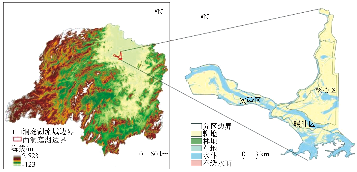
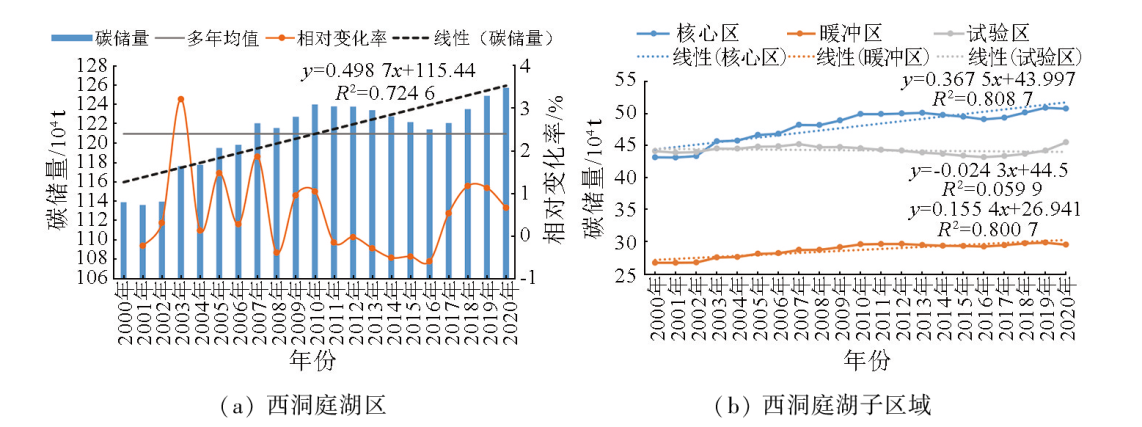
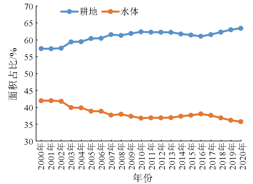
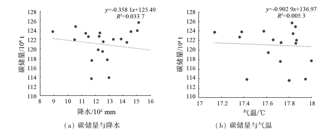
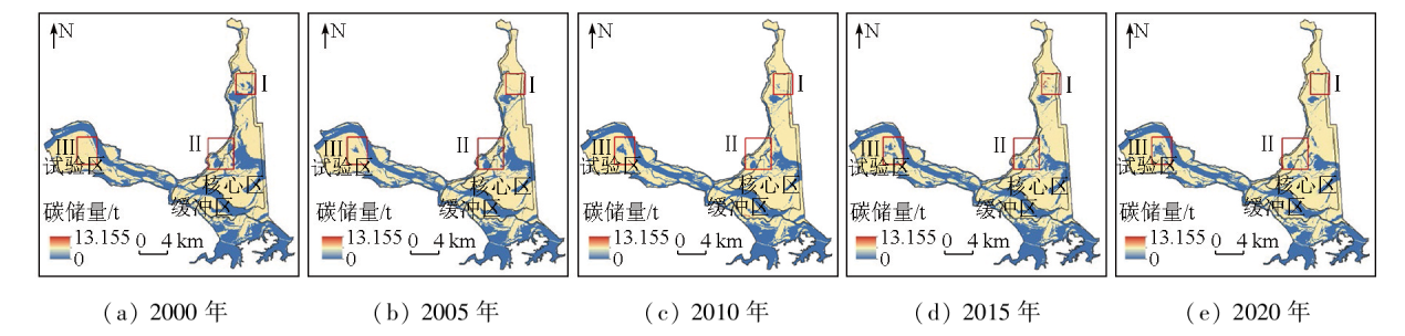
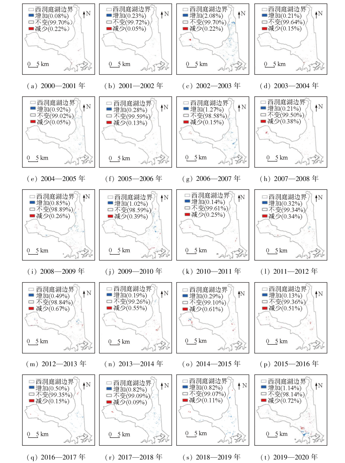
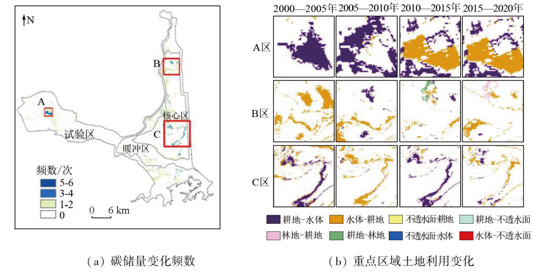
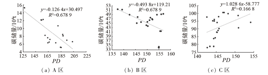
Abstract Analyzing the carbon stock in a terrestrial ecosystem is a key link for research on the global and regional carbon cycle. Assessing the long-time-series carbon stock in the West Dongting Lake National Nature Reserve will provide scientific data for regional ecological monitoring and management. Based on the land use data from 2000 to 2020, this study explored the spatiotemporal changes in the carbon stock of the nature reserve based on the carbon stock estimated using the InVEST model and identified key areas of carbon stock changes. The results indicate that in the past two decades, the carbon stock in the nature reserve exhibited a fluctuating upward trend, ranging from 113.5×10⁴ to 125.7×10⁴ tons. The carbon stock presented relative changing rates of less than 2% during this period, except for 2003, when the changing rate was 3.2%. Over the past two decades, the core zone of the nature reserve ranked first in carbon stock among subregions every year, followed by the pilot zones. The carbon stock in most areas of the nature reserve remained unchanged or changed slightly. Nevertheless, there still existed some areas with significant changes in the carbon stock. The key areas of carbon stock changes featured diverse spatial distribution patterns of carbon stock, such as concentrated, linear, and scattered patterns, with land use types in these areas exhibiting corresponding change intensities of carbon stock. The changes in the carbon stock in the pilot zones were greatly affected by human interference, while those in the core area were primarily related to precipitation. The results of this study will assist in scientifically promoting carbon neutrality and peak carbon dioxide emissions in the West Dongting Lake National Nature Reserve.
|
| Keywords
West Dongting Lake National Nature Reserve
carbon stock
InVEST
spatiotemporal distribution
|
|
|
|
Issue Date: 23 December 2024
|
|
|
| [1] |
IPCC. Climate change 2021:The physical science basis,contribution of working group I to the sixth assessment report of the intergovernmental panel on climate change[R]. Cambridge: Cambridge University Press, 2021
|
| [2] |
方精云, 朱江玲, 石岳. 生态系统对全球变暖的响应[J]. 科学通报, 2018, 63(2):136-140.
|
| [2] |
Fang J Y, Zhu J L, Shi Y. The responses of ecosystems to global warming[J]. Chinese Science Bulletin, 2018, 63(2):136-140.
|
| [3] |
朱媛媛, 张瑞, 顾江, 等. “双碳”目标下长江中游城市群生态福利绩效变化的经济——环境效应[J]. 经济地理, 2023, 43(5):89-96.
doi: 10.15957/j.cnki.jjdl.2023.05.010
|
| [3] |
Zhu Y Y, Zhang R, Gu J, et al. Economic and environmental effects of ecological well-being performance change of urban agglomeration in the middle reaches of the Yangtze River under the carbon peaking and carbon neutrality goals[J]. Economic Geography, 2023, 43(5):89-96.
doi: 10.15957/j.cnki.jjdl.2023.05.010
|
| [4] |
杨元合, 石岳, 孙文娟, 等. 中国及全球陆地生态系统碳源汇特征及其对碳中和的贡献[J]. 中国科学:生命科学, 2022, 52(4):534-574.
|
| [4] |
Yang Y H, Shi Y, Sun W J, et al. Terrestrial carbon sinks in China and around the world and their contribution to carbon neutrality[J]. Scientia Sinica(Vitae). 2022, 52(4):534-574.
|
| [5] |
Zhao J F, Liu D S, Zhu Y J, et al. A review of forest carbon cycle models on spatiotemporal scales[J]. Journal of Cleaner Production, 2022, 339:130692.
|
| [6] |
张祯祺, 蔡惠文, 张平平, 等. 基于GEE遥感云平台的三江源植被碳源/汇时空变化研究[J]. 自然资源遥感, 2023, 35(1):231-242.doi:10.6046/zrzyyg.2022042.
|
| [6] |
Zhang Z Q, Cai H W, Zhang P P, et al. A GEE - based study on the temporal and spatial variations in the carbon source/sink function of vegetation in the Three-River Headwaters region[J]. Remote Sensing for Natural Resources, 2023, 35(1):231-242.doi:10.6046/zrzyyg.2022042.
|
| [7] |
汪涛, 朴世龙. 青藏高原陆地生态系统碳汇估算:进展、挑战与展望[J]. 第四纪研究, 2023, 43(2):313-323.
|
| [7] |
Wang T, Piao S L. Estimate of terrestrial carbon balance over the Tibetan Plateau:Progresses,challenges and perspectives[J]. Quaternary Sciences, 2023, 43(2):313-323.
|
| [8] |
刘坤, 张慧, 孔令辉, 等. 陆地生态系统碳汇评估方法研究进展[J]. 生态学报, 2023, 43(10):4294-4307.
|
| [8] |
Liu K, Zhang H, Kong L H, et al. An overview of terrestrial ecosystem carbon sink assessment methods towards achieving carbon neutrality in China[J]. Acta Ecologica Sinica, 2023, 43(10):4294-4307.
|
| [9] |
朴世龙, 何悦, 王旭辉, 等. 中国陆地生态系统碳汇估算:方法、进展、展望[J]. 中国科学:地球科学, 2022, 52(6):1010-1020.
|
| [9] |
Piao S L, He Y, Wang X H, et al. Carbon sequestration estimation of terrestrial ecosystem in China:Method,progress and prospect[J]. Scientia Sinica (Terrae), 2022, 52(6):1010-1020.
|
| [10] |
Yao Y T, Piao S L, Wang T. Future biomass carbon sequestration capacity of Chinese forests[J]. Science Bulletin, 2018, 63(17):1108-1117.
doi: 10.1016/j.scib.2018.07.015
pmid: 36658990
|
| [11] |
令狐大智, 罗溪, 朱帮助. 森林碳汇测算及固碳影响因素研究进展[J]. 广西大学学报(哲学社会科学版), 2022, 44(3):142-155.
|
| [11] |
Linghu D Z, Luo X, Zhu B Z. Review on forest carbon sink measurement and influential factors of carbon sequestration[J]. Journal of Guangxi University(Philosophy and Social Science), 2022, 44(3):142-155.
|
| [12] |
隋玉正, 孙大鹏, 李淑娟, 等. 碳储存变化背景下东营市海岸带生态系统保护修复[J]. 生态学报, 2021, 41(20):8112-8123.
|
| [12] |
Sui Y Z, Sun D P, Li S J, et al. Study of coastal zone ecosystem restoration in the context of carbon storage change:A case of Dongying City[J]. Acta Ecologica Sinica, 2021, 41(20):8112-8123.
|
| [13] |
Hwang J, Choi Y, Kim Y, et al. Analysis of the effect of environmental protected areas on land-use and carbon storage in a megalopolis[J]. Ecological Indicators, 2021, 133:108352.
|
| [14] |
刘洋, 张军, 周冬梅, 等. 基于InVEST模型的疏勒河流域碳储量时空变化研究[J]. 生态学报, 2021, 41(10):4052-4065.
|
| [14] |
Liu Y, Zhang J, Zhou D M, et al. Temporal and spatial variation of carbon storage in the Shule River Basin based on InVEST model[J]. Acta Ecologica Sinica, 2021, 41(10):4052-4065.
|
| [15] |
韩玉, 丁素婷, 杨太保. 山西南部中条山生态系统碳储量时空分布及驱动因素[J]. 中国环境科学, 2023, 43(3):1298-1306.
|
| [15] |
Han Y, Ding S T, Yang T B. Spatial and temporal distribution and driving factors of carbon storage in Zhongtiao Mountain ecosystem in southern Shanxi Province[J]. China Environmental Science, 2023, 43(3):1298-1306.
|
| [16] |
杨潋威, 赵娟, 朱家田, 等. 基于PLUS和InVEST模型的西安市生态系统碳储量时空变化与预测[J]. 自然资源遥感, 2022, 34(4):175-182.doi:10.6046/zrzyyg.2021348.
|
| [16] |
Yang L W, Zhao J, Zhu J T, et al. Spatial-temporal change and prediction of carbon stock in the ecosystem of Xi’an based on PLUS and InVEST models[J]. Remote Sensing for Natural Resources, 2022, 34(4):175-182.doi:10.6046/zrzyyg.2021348
|
| [17] |
丁岳, 王柳柱, 桂峰, 等. 基于InVEST模型和PLUS模型的环杭州湾生态系统碳储量[J]. 环境科学, 2023, 44(6):3343-3352.
|
| [17] |
Ding Y, Wang L Z, Gui F, et al. Ecosystem carbon storage in Hangzhou Bay area based on InVEST and PLUS models[J]. Environmental Science, 2023, 44(6):3343-3352.
|
| [18] |
张猛, 陈淑丹, 林辉, 等. 洞庭湖湿地净初级生产力估算研究[J]. 遥感学报, 2023, 27(6):1454-1466.
|
| [18] |
Zhang M, Chen S D, Lin H, et al. Net primary productivity estimation of Dongting Lake wetland[J]. National Remote Sensing Bulletin, 2023, 27(6):1454-1466.
|
| [19] |
Zhang M, Yuan N Q, Lin H, et al. Quantitative estimation of the factors impacting spatiotemporal variation in NPP in the Dongting Lake wetlands using Landsat time series data for the last two decades[J]. Ecological Indicators, 2022, 135:108544.
|
| [20] |
Zhou W Q, Wang J L, Han Y, et al. Scenario simulation of the relationship between land-use changes and ecosystem carbon storage:A case study in Dongting Lake Basin,China[J]. International Journal of Environmental Research and Public Health, 2023, 20(6):4835.
|
| [21] |
An X X, Jin W P, Long X R, et al. Spatial and temporal evolution of carbon stocks in Dongting Lake wetlands based on remote sensing data[J]. Geocarto International, 2022, 37(27):14983-15009.
|
| [22] |
刘晓辉, 姜明, 朱庆龙, 等. 吉林莫莫格国家级自然保护区边界和功能区范围调整初探[J]. 湿地科学, 2021, 19(5):527-533.
|
| [22] |
Liu X H, Jiang M, Zhu Q L, et al. Adjustment of boundary and domain of functional areas of Momoge national nature reserve,Jilin Province[J]. Wetland Science, 2021, 19(5):527-533.
|
|
Viewed |
|
|
|
Full text
|
|
|
|
|
Abstract
|
|
|
|
|
Cited |
|
|
|
|
| |
Shared |
|
|
|
|
| |
Discussed |
|
|
|
|
 2024,
Vol. 36
2024,
Vol. 36