Please wait a minute...
 
Remote Sensing for Land & Resources    2018, Vol. 30 Issue (1) : 7-7     DOI: 10.6046/gtzyyg.2018.01.02
Orginal Article |
Application of FY-2E data to remote sensing monitoring of sea fog in Fujian coastal region
Chungui ZHANG(), Bingqing LIN
Fujian Provincial Meteorological Science Institute, Fuzhou 350001, China
Download: PDF(901 KB)   HTML
Export: BibTeX | EndNote | Reference Manager | ProCite | RefWorks    
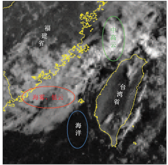
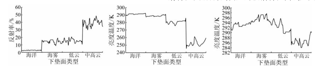
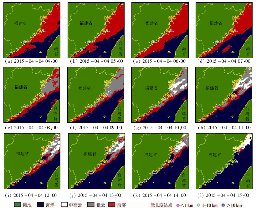
Abstract  

In this paper, the authors analyzed the variation law of visible light, thermal infrared band and mid-infrared band of FY geostationary satellite for sea fog, clouds and sea surface (clear sky) in Taiwan Strait, which was based on a lot of experimental analyses by using different phases of satellite data, combined with the visibility data of automatic meteorological stations. On such a basis, reflectivity threshold was used to separate sea fog and cloud from sea surface, and brightness temperature threshold was used to separate sea fog and low cloud from middle and high cloud. In addition, night sea fog was automatically identified by the normalized difference index of mid-infrared and thermal infrared band. Finally, the automatic monitoring software system of Taiwan Strait sea fog was established, and surface observation data were used to examine the precision of remote sensing monitoring. The research results show that FY geostationary satellite could make up for the deficiency of Polar Orbit Satellite in time resolution, and it has a good performance on the dynamic monitoring service of Taiwan Strait. A comparison shows that the remote sensing monitoring results of sea fog are in accordance with observation results, and the monitoring accuracy is more than 70% in daytime. Night time accuracy is lower than that of the day time, and there exists limitation in the separation of sea fog and low cloud.

Keywords FY-2E satellite      sea fog      remote sensing monitoring      Fujian coastal region     
:  TP751.1  
Issue Date: 08 February 2018
Service
E-mail this article
E-mail Alert
RSS
Articles by authors
Chungui ZHANG
Bingqing LIN
Cite this article:   
Chungui ZHANG,Bingqing LIN. Application of FY-2E data to remote sensing monitoring of sea fog in Fujian coastal region[J]. Remote Sensing for Land & Resources, 2018, 30(1): 7-7.
URL:  
https://www.gtzyyg.com/EN/10.6046/gtzyyg.2018.01.02     OR     https://www.gtzyyg.com/EN/Y2018/V30/I1/7
通道 波长范围/μm 波段性质
IR1 10.29~11.45 热红外
IR2 11.59~12.79 热红外
IR3 6.32~7.55 中红外
IR4 3.59~4.09 中红外
VIS 0.510~0.905 可见光
Tab.1  The observation channels parameter of FY-2E satellite
Fig.1  The FY-2E satellite visible light image of typical clouds and sea fog
Fig.2  FY-2E satellite spectrum characteristic curve of ocean, clouds and sea fog in Taiwan Strait
Fig.3  One sea fog dynamic monitoring by using FY-2E satellite in Taiwan Strait
监测站点 卫星监测有雾 卫星监测无雾 合计
地面观测有雾 2 912 1 185 4 097
地面观测无雾 579 1 412 1 991
合计 3 491 2 597 6 088
Tab.2  Precision analysis of daytime sea fog remote sensing monitoring in Taiwan Strait in 2015(个)
[1] 郑新江. 黄海海雾的卫星云图特征分析[J].气象,1988,14(6):7-9.
[1] Zheng X J.On satellite imagery features of sea fogs over the Yellow Sea[J].Meteorological Monthly,1988,14(6):7-9.
[2] Ellrod G P.Advances in the detection and analysis of fog at night using GOES multispectral infrared imagery[J].Weather and Forecasting,1995,10(3):606-619.
[3] Ahn M H,Sohn E H,Hwang B J.A new algorithm for sea fog/stratus detection using GMS-5 IR data[J].Advances in Atmospheric Sciences,2003,20(6):899-913.
[4] 鲍献文,王鑫,孙立潭,等.卫星遥感全天候监测海雾技术与应用[J].高技术通讯,2005,15(1):101-106.
[4] Bao X W,Wang X,Sun L T,et al.The weatherproof detection system of sea fog by remote sensing and its applications[J].High Technology Letters,2005,15(1):101-106.
[5] 张纪伟,张苏平,吴晓京,等.基于MODIS的黄海海雾研究——海雾特征量反演[J].中国海洋大学学报,2009,39(S1):311-318.
[5] Zhang J W,Zhang S P,Wu X J,et al.The research on Yellow Sea sea fog based on MODIS data:Sea fog properties retrieval and spatial-temporal distribution[J].Periodical of Ocean University of China,2009,39(S1):311-318.
[6] 马慧云,范冲,赵向东.基于云雾与晴空地表混合像元的云雾检测算法[J].国土资源遥感,2010,22(1):55-59.doi:10.6046/gtzyyg/2010.01.09.
[6] Ma H Y,Fan C,Zhao X D.An algorithm for separating cloud-fog from surface features based on mixed pixels[J].Remote Sensing for Land and Resources,2010,22(1):55-59.doi:10.6046/gtzyyg/2010.01.09.
[7] 张伟康,马慧云,邹峥嵘,等.基于SBDART辐射传输模型的夜间辐射雾自动检测及时间序列分析[J].国土资源遥感,2014,26(2):80-86.doi:10.6046/gtzyyg/2014.02.14.
[7] Zhang W K,Ma H Y,Zou Z R,et al.Automatic detection of night time radiation fog based on SBDART radiative transfer model and the analysis of time series[J].Remote Sensing for Land and Resources,2014,26(2):80-86.doi:10.6046/gtzyyg/2014.02.14.
[8] 吴晓京,李三妹,廖蜜,等.基于20年卫星遥感资料的黄海、渤海海雾分布季节特征分析[J].海洋学报,2015,37(1):63-72.
[8] Wu X J,Li S M,Liao M,et al.Analyses of seasonal feature of sea fog over the Yellow Sea and Bohai Sea based on the recent 20 years of satellite remote sensing data[J].Acta Oceanologica Sinica,2015,37(1):63-72.
[9] 何月,张小伟,杜惠良,等.利用静止气象卫星监测浙江海上大雾[J].遥感技术与应用,2015,30(3):599-606.
[9] He Y,Zhang X W,Du H L,et al.Monitoring sea fog of Zhejiang from geostationary meteorological satellite data[J].Remote Sensing Technology and Application,2015,30(3):599-606.
[10] Bendix J,Thies B,Cermak J,et al.Ground fog detection from space based on MODIS daytime data-a feasibility study[J].Weather and Forecasting,2005,20(6):989-1005.
[1] CHEN Dong, YAO Weiling. Automatic numbering and method improvement of mine patches based on ArcPy and custom ArcToolbox[J]. Remote Sensing for Land & Resources, 2021, 33(2): 262-269.
[2] WANG Jie, LIU Xiaoyang, YANG Jinzhong, ZHOU Yingjie, An Na, WANG Zhihui. Typical model analysis of mine geological environment restoration and management in Zhejiang Province based on domestic high-resolution satellite data[J]. Remote Sensing for Land & Resources, 2020, 32(3): 216-221.
[3] DIAO Mingguang, LIU Wenjing, LI Jing, LIU Fang, WANG Yanzuo. Dynamic change detection method of vector result data in mine remote sensing monitoring[J]. Remote Sensing for Land & Resources, 2020, 32(3): 240-246.
[4] Haigang SHI, Chunli LIANG, Jianyong ZHANG, Chunlei ZHANG, Xu CHENG. Remote sensing survey of the influence of coastline changes on the thermal discharge in the vicinity of Tianwan Nuclear Power Station[J]. Remote Sensing for Land & Resources, 2020, 32(2): 196-203.
[5] Xi LIU, Lina HAO, Xianhua YANG, Jie HUANG, Zhi ZHANG, Wunian YANG. Research and implementation of rapid statistical methods for mine remote sensing monitoring indicators[J]. Remote Sensing for Land & Resources, 2020, 32(2): 259-265.
[6] Jie WANG, Yaqiu YIN, Hang YU, Cunhao JIANG, Yu WAN. Remote sensing monitoring of mine geological environment in Zhejiang Province based on RS and GIS[J]. Remote Sensing for Land & Resources, 2020, 32(1): 232-236.
[7] Yuling ZHAO, Jinzhong YANG, Yaqiu YIN, Hang ZHAO, Jinbao HE, Han ZHANG. Research on remote sensing monitoring of zirconium-titanium sand mine exploitation and strategies of ecological restoration on the eastern beach of Hainan Island[J]. Remote Sensing for Land & Resources, 2019, 31(4): 143-150.
[8] Haiping WU, Shicun HUANG. Research on new construction land information extraction based on deep learning: Innovation exploration of the national project of land use monitoring via remote sensing[J]. Remote Sensing for Land & Resources, 2019, 31(4): 159-166.
[9] Zhen CHEN, Yunshi ZHANG, Yuanyu ZHANG, Lingling SANG. A study of remote sensing monitoring methods for the high standard farmland[J]. Remote Sensing for Land & Resources, 2019, 31(2): 125-130.
[10] Xianhua YANG, Jie HUANG, Li TIAN, Bei PENG, Lixiao XIAO, Xinlong SONG. Application of mine remote sensing monitoring to analysis of mine goaf stability[J]. Remote Sensing for Land & Resources, 2018, 30(3): 143-150.
[11] XUE Qing, WU Wei, LI Mingsong, DONG Shuangfa, ZHANG Xinyi, SHI Haigang. Application of GF-1 satellite data to remote sensing monitoring of the mine[J]. REMOTE SENSING FOR LAND & RESOURCES, 2017, 29(s1): 67-72.
[12] WANG Yijun, ZHAO Jun, WEI Wei, HAN Liqin. Remote sensing investigation and analysis of wetland in Gansu section of Heihe River Basin in the past 14 years[J]. REMOTE SENSING FOR LAND & RESOURCES, 2017, 29(3): 111-117.
[13] SONG Yang, FANG Shibo, LIANG Hanyue, KE Lina. Comparison and application of agricultural drought indexes based on MODIS data[J]. REMOTE SENSING FOR LAND & RESOURCES, 2017, 29(2): 215-220.
[14] DIAO Mingguang, XUE Tao, LIANG Jiandong, LI Jiancun, LIU Qiong. Description method for complex constraint of mine remote sensing monitoring attribute data[J]. REMOTE SENSING FOR LAND & RESOURCES, 2016, 28(4): 197-201.
[15] YAN Yunpeng, LIU Gang, LIU Jianyu, HAN Cong, ZHAO Zixian. Snow cover remote sensing monitoring in the west of Ngari area in northern Tibet from 2013 to 2014[J]. REMOTE SENSING FOR LAND & RESOURCES, 2016, 28(4): 185-190.
Viewed
Full text


Abstract

Cited

  Shared   
  Discussed   
京ICP备05055290号-2
Copyright © 2017 Remote Sensing for Natural Resources
Support by Beijing Magtech