|
|
|
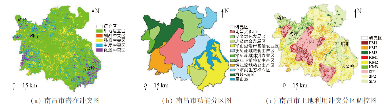
Abstract The rapid social and economic development and the trend of human migration to large- and mid-size cities, especially provincial capitals, have significantly intensified land use conflicts. The coordination among production, living, and ecological spaces is significant for sustainable, regional social and economic development. This study created a multi-purpose suitability assessment model from the perspective of the production, living, and ecological functions, identified the production, living, and ecological suitability, as well as the intensity of potential land use conflicts, in Nanchang City, China while considering land space background and planning objectives for differentiated regional regulation. The results indicate that over 65% of areas in the city are suitable for production and living. Areas with ecological, productive, and living suitability differ in spatial distribution and structural composition and exhibit pronounced overlaps. This indicates potential land use conflicts. The conflict identification results reveal that the areas with severe, strong, moderate, and weak land use conflicts account for 0.53%, 18.81%, 5.77%, and 5.67%, respectively. Given the different spatial distributions, area proportions, and characteristics of areas with potential land use conflicts, differentiated regulations are required. Based on comprehensive considerations of the conflict identification results and the functional zoning stated in the Nanchang City Land and Space Master Plan (2021—2035), this study determined nine major zones for differentiated regulation. This study made some preliminary attempts in zoning regulation against land use conflicts while considering both land use suitability and the requirements for social and economic development. The results of this study will provide a scientific basis for identifying land use conflicts and optimizing land space layout in other similar cities.
|
| Keywords
land use conflict
multi-purpose suitability
production, living, and ecological functions
zoning regulation
Nanchang City
|
|
|
|
Issue Date: 17 February 2025
|
|
|
| [1] |
阮松涛, 吴克宁. 城镇化进程中土地利用冲突及其缓解机制研究——基于非合作博弈的视角[J]. 中国人口·资源与环境, 2013, 23(s2):388-392.
|
| [1] |
Ruan S T, Wu K N. Research of the land use conflict and mitigation mechanism during the urbanization in China[J]. China Population,Resources and Environment, 2013, 23(s2):388-392.
|
| [2] |
Wehrmann B. Land conflicts:A practical guide to dealing with land disputes[M]. Eschborn,Germany: Deutsche Gesellschaft für Technische Zusammenarbeit GmbH, 2008.
|
| [3] |
Pavón D, Ventura M, Ribas A, et al. Land use change and socio-environmental conflict in the Alt Empordà County (Catalonia,Spain)[J]. Journal of Arid Environments, 2003, 54(3):543-552.
|
| [4] |
de Groot R. Function-analysis and valuation as a tool to assess land use conflicts in planning for sustainable,multi-functional landscapes[J]. Landscape and Urban Planning, 2006, 75(3/4):175-186.
|
| [5] |
Adam Y O, Pretzsch J, Darr D. Land use conflicts in central Sudan:Perception and local coping mechanisms[J]. Land Use Policy, 2015,42:1-6.
|
| [6] |
Delgado-Matas C, Mola-Yudego B, Gritten D, et al. Land use evolution and management under recurrent conflict conditions:Umbundu agroforestry system in the Angolan Highlands[J]. Land Use Policy, 2015,42:460-470.
|
| [7] |
邹利林, 刘彦随, 王永生. 中国土地利用冲突研究进展[J]. 地理科学进展, 2020, 39(2):298-309.
doi: 10.18306/dlkxjz.2020.02.011
|
| [7] |
Zou L L, Liu Y S, Wang Y S. Research progress and prospect of land-use conflicts in China[J]. Progress in Geography, 2020, 39(2):298-309.
doi: 10.18306/dlkxjz.2020.02.011
|
| [8] |
王健, 刘欣雨. 基于“风险—效应”的土地利用空间冲突识别与测度[J]. 农业工程学报, 2022, 38(12):291-300.
|
| [8] |
Wang J, Liu X Y. Recognizing and measuring spatial conflict of land use via “risk-effect”[J]. Transactions of the Chinese Society of Agricultural Engineering, 2022, 38(12):291-300.
|
| [9] |
王检萍, 余敦, 卢一乾, 等. 基于“三生”适宜性的县域土地利用冲突识别与分析[J]. 自然资源学报, 2021, 36(5):1238-1251.
doi: 10.31497/zrzyxb.20210512
|
| [9] |
Wang J P, Yu D, Lu Y Q, et al. Recognition and analysis of land use conflicts at county level based on “production-living-ecological” suitability[J]. Journal of Natural Resources, 2021, 36(5):1238-1251.
|
| [10] |
田柳兰, 吕思雨, 毋兆鹏, 等. 乌鲁木齐市土地利用变化及其空间冲突测度[J]. 自然资源遥感, 2023, 35(4):282-291.doi: 10.6046/zrzyyg.2022341.
|
| [10] |
Tian L L, Lyu S Y, Wu Z P, et al. Measurement of land use change and spatial conflict in Urumqi[J]. Remote Sensing for Natural Resources, 2023, 35(4):282-291.doi: 10.6046/zrzyyg.2022341.
|
| [11] |
王爱民, 马学广, 闫小培. 基于行动者网络的土地利用冲突及其治理机制研究——以广州市海珠区果林保护区为例[J]. 地理科学, 2010, 30(1):80-85.
|
| [11] |
Wang A M, Ma X G, Yan X P. Land use conflicts and their governance mechanics on actors network theory: A case of fruit tree protection zone of Haizhu District,Guangzhou City[J]. Scientia Geographica Sinica, 2010, 30(1):80-85.
|
| [12] |
张潇, 谷人旭. 土地利用冲突的时空格局刻画与多情景模拟研究——以长江三角洲城市群为例[J]. 地理研究, 2022, 41(5):1311-1326.
doi: 10.11821/dlyj020210375
|
| [12] |
Zhang X, Gu R X. Spatio-temporal pattern and multi-scenario simulation of land use conflict:A case study of the Yangtze River Delta urban agglomeration[J]. Geographical Research, 2022, 41(5):1311-1326.
|
| [13] |
王珊珊, 毋兆鹏, 王娟娟, 等. 新疆乌鲁木齐市“三生”用地的空间冲突研究[J]. 水土保持通报, 2022, 42(2):330-337.
|
| [13] |
Wang S S, Wu Z P, Wang J J, et al. Spatial conflicts of productive-living-ecological land in Urumqi City of Xinjiang Wei Autonomous Region[J]. Bulletin of Soil and Water Conservation, 2022, 42(2):330-337.
|
| [14] |
王奥枫, 陈世恒, 韦彦章, 等. 基于F-H方法的漓江流域土地利用冲突识别[J]. 山地学报, 2021, 39(4):506-514.
|
| [14] |
Wang A F, Chen S H, Wei Y Z, et al. Land use conflict based on F-H method in the Lijiang River basin,China[J]. Mountain Research, 2021, 39(4):506-514.
|
| [15] |
肖练练, 刘青青, 虞虎, 等. 基于土地利用冲突识别的国家公园社区调控研究——以钱江源国家公园为例[J]. 生态学报, 2020, 40(20):7277-7286.
|
| [15] |
Xiao L L, Liu Q Q, Yu H, et al. Community regulation in national park based on land use conflict identification:A case study on Qianjiangyuan National Park[J]. Acta Ecologica Sinica, 2020, 40(20):7277-7286.
|
| [16] |
王越, 李佩泽, 李炆颖, 等. 基于演化博弈的土地利用冲突缓解机制研究——以沈抚新区为例[J]. 中国土地科学, 2021, 35(12):87-97.
|
| [16] |
Wang Y, Li P Z, Li W Y, et al. Mitigation mechanism of land use conflicts based on evolutionary game:A case study of Shenfu New Area[J]. China Land Science, 2021, 35(12):87-97.
|
| [17] |
杨永芳, 安乾, 朱连奇. 基于PSR模型的农区土地利用冲突强度的诊断[J]. 地理科学进展, 2012, 31(11):1552-1560.
|
| [17] |
Yang Y F, An Q, Zhu L Q. Diagnosis based on the PSR model of rural land-use conflicts intensity[J]. Progress in Geography, 2012, 31(11):1552-1560.
doi: 10.11820/dlkxjz.2012.11.017
|
| [18] |
Iojă C I, Niţă M R, Vânău G O, et al. Using multi-criteria analysis for the identification of spatial land-use conflicts in the Bucharest Metropolitan Area[J]. Ecological Indicators, 2014,42:112-121.
|
| [19] |
王娟娟, 毋兆鹏, 王珊珊, 等. 干旱区河谷绿洲土地利用冲突格局分析[J]. 自然资源遥感, 2021, 33(4):243-251.doi:10.6046/zyzyyg.2021044.
|
| [19] |
Wang J J, Wu Z P, Wang S S, et al. An analysis of the pattern of land-use conflicts in valley oases in arid areas[J]. Remote Sensing for Natural Resources, 2021, 33(4):243-251.doi: 10.6046/zrzyyg.2021044.
|
| [20] |
岳海凤, 闵婕, 廖梓均. 基于多目标适宜性和竞争力的区域潜在土地利用冲突的诊断研究[J]. 重庆师范大学学报(自然科学版), 2022, 39(3):116-127.
|
| [20] |
Yue H F, Min J, Liao Z J. Research on regional potential land use conflict diagnosis based on multi-objective suitability and competitiveness[J]. Journal of Chongqing Normal University (Natural Science), 2022, 39(3):116-127.
|
| [21] |
Carr M H, Zwick P D. Smart land-use analysis:The LUCIS model land-use conflict identification strategy[M]. Redlands, Calif.:ESRI Press, 2007.
|
| [22] |
王建英, 邹利林, 李梅凎. 基于“三生”适宜性的旅游度假区潜在土地利用冲突识别与治理[J]. 农业工程学报, 2019, 35(24):279-288,328.
|
| [22] |
Wang J Y, Zou L L, Li M G. Identification and governance of potential land use conflicts in tourism resort based on ecological-production-living suitability[J]. Transactions of the Chinese Society of Agricultural Engineering, 2019, 35(24):279-288,328.
|
| [23] |
汪永华, 蔚远江, 吴珍珍, 等. 基于ArcGIS空间图形插值法的致密气资源评价——以俄罗斯蒂曼—伯朝拉盆地为例[J]. 地球科学与环境学报, 2023, 45(5):1246-1256.
|
| [23] |
Wang Y H, Yu Y J, Wu Z Z, et al. Tight gas resourc evaluation based on ArcGIS spatial graph interpolation method:A case study of Timan-Pechora Basin in Russia[J]. Journal of Earth Sciences and Environment, 2023, 45(5):1246-1256.
|
| [24] |
扈万泰, 王力国, 舒沐晖. 城乡规划编制中的“三生空间”划定思考[J]. 城市规划, 2016, 40(5):21-26,53.
|
| [24] |
Hu W T, Wang L G, Shu M H. Reflections on delimiting the three basic spaces in the compilation of urban and rural plans[J]. City Planning Review, 2016, 40(5):21-26,53.
|
| [25] |
陈竹安, 冯祥瑞, 洪志强, 等. 南昌市土地利用的空间冲突风险评估及分区优化研究——基于“三生空间”视角[J]. 世界地理研究, 2021, 30(3):533-545.
doi: 10.3969/j.issn.1004-9479.2021.03.2019676
|
| [25] |
Chen Z A, Feng X R, Hong Z Q, et al. Research on spatial conflict calculation and zoning optimization of land use in Nanchang City from the perspective of “three living spaces”[J]. World Regional Studies, 2021, 30(3):533-545.
|
| [26] |
陈竹安, 冯祥瑞, 洪志强, 等. 南昌市土地利用的空间冲突测算与分析[J]. 地域研究与开发, 2020, 39(3):150-155.
|
| [26] |
Chen Z A, Feng X R, Hong Z Q, et al. Calculation and analysis of spatial conflicts in land use of Nanchang City[J]. Areal Research and Development, 2020, 39(3):150-155.
|
| [27] |
谭术魁. 我国土地冲突的分类方案探讨[J]. 中国农业资源与区划, 2008, 29(4):27-30.
|
| [27] |
Tan S K. Discussion on classification scheme of land conflict in China[J]. Chinese Journal of Agricultural Resources and Regional Planning, 2008, 29(4):27-30.
|
|
Viewed |
|
|
|
Full text
|
|
|
|
|
Abstract
|
|
|
|
|
Cited |
|
|
|
|
| |
Shared |
|
|
|
|
| |
Discussed |
|
|
|
|
 2025,
Vol. 37
2025,
Vol. 37
 ), CHEN Meiqiu(