|
|
 |
|

|
|
|
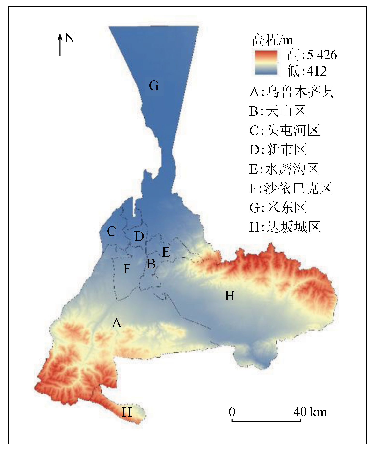
Changes and spatial conflict measurement of land use in Urumqi City |
TIAN Liulan1( ), LYU Siyu1, WU Zhaopeng1,2(), WANG Juanjuan1, SHI Xinpeng1 ), LYU Siyu1, WU Zhaopeng1,2(), WANG Juanjuan1, SHI Xinpeng1 |
1. School of Geographic Science and Tourism, Xinjiang Normal University, Urumqi 830054, China
2. Laboratory of Lake Environment and Resources in Arid Region of Xinjiang, Urumqi 830054, China |
|
|
|
|
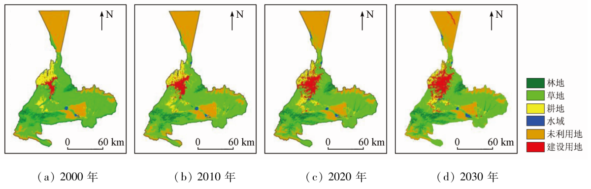
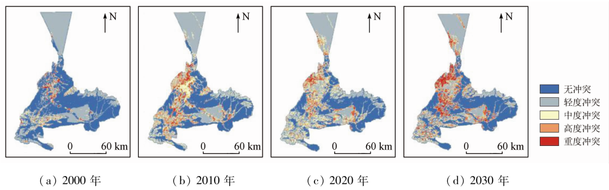
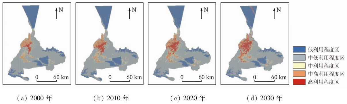
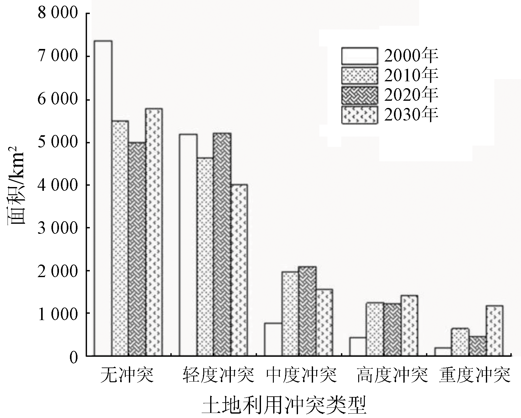
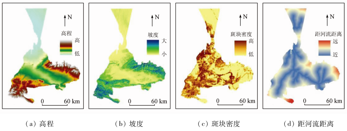
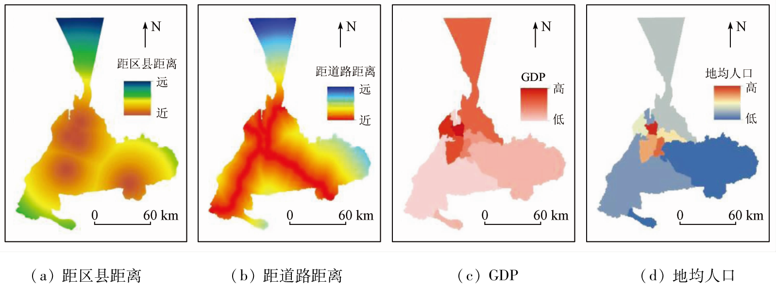
Abstract Identifying land use conflicts holds critical significance for sustainable socio-economic development and ecological civilization construction. Since Urumqi City is situated in the core region of the Silk Road Economic Belt, investigating the causes and manifestations of its land use conflicts arising from urban development, oasis agriculture, and ecological environment becomes an urgent and necessary task. With Urumqi as the study area, this study analyzed its land use characteristics in 2000, 2010, and 2020, as well as those in 2030 simulated from the FLUS model. Based on this analysis and the pressure-state-response (PSR) model, a land use conflict intensity measurement model was constructed to evaluate the land use conflicts over the four periods. Finally, a geographic detector was employed to quantitatively analyze the factors driving land use conflicts in the study area. The findings indicate that: ① The land use between 2000 and 2030 exhibited significant spatial differentiation, showing increased construction land, forest land, and water areas, but decreased grassland, arable land, and unused land; ② The comprehensive indices of land use indicate low to medium utilization degrees but an overall rising trend, suggesting land use in a development stage; ③ Significant spatial changes occurred in land use conflicts between 2000 and 2030. The conflict-free and mild conflict zones occupied the largest proportions, the moderate conflict zones showed normal distributions, and severe and high-level conflict zones increased annually, with the highest increase observed in high-level conflict zones; ④ From 2000 to 2010, the hotspots of land use conflicts were distributed primarily in the north and southwest of the central urban area. From 2010 to 2020, they spread to the periphery of forest land in the southern and northern mountainous areas, and the areas near the alluvial fans on both sides of the salt lake in the Dabancheng District. From 2020 to 2030, the hotspots are still mainly located around the land for construction and near the forest land in mountainous areas but significantly decreased in the mountainous areas; ⑤ As demonstrated by one-way influence analysis of spatial differentiation drivers on land use conflicts, the influences of factors are in the order of patch density > population density > GDP > slope > elevation > distance from districts and counties > distance from rivers > distance from roads. Additionally, the interaction detection analysis indicates (patch density ∩ elevation) > (patch density ∩ average land population)>(patch density ∩ distance from roads). This study serves as a reference for effectively managing the conflicting demands between economic development and ecological conservation in Urumqi and enhancing the future land use composition.
|
| Keywords
FLUS model
land use change
land use conflict
geographical detector
Urumqi
|
|
|
|
Issue Date: 21 December 2023
|
|
|
| [1] |
江颂, 蒙吉军. 土地利用冲突研究进展:内容与方法[J]. 干旱区地理, 2021, 44(3):877-887.
|
| [1] |
Jiang S, Meng J J. Process of land use conflict research: Contents and methods[J]. Arid Land Geography, 2021, 44(3):877-887.
|
| [2] |
王检萍, 余敦, 卢一乾, 等. 基于“三生”适宜性的县域土地利用冲突识别与分析[J]. 自然资源学报, 2021, 36(5):1238-1251.
doi: 10.31497/zrzyxb.20210512
|
| [2] |
Wang J P, Yu D, Lu Y Q, et al. Recognition and analysis of land use conflicts at county level based on “Production-Living-Ecological” suitability[J]. Journal of Natural Resources, 2021, 36(5):1238-1251.
doi: 10.31497/zrzyxb.20210512
url: http://www.jnr.ac.cn/EN/10.31497/zrzyxb.20210512
|
| [3] |
Roehl W S, Fesenmaier D R. Tourism land use conflict in the United States[J]. Annals of Tourism Research, 1987, 14(4):471-485.
doi: 10.1016/0160-7383(87)90065-X
url: https://linkinghub.elsevier.com/retrieve/pii/016073838790065X
|
| [4] |
Campbell D J, Gichohi H, Mwanqi A, et al. Land use conflict in Kajiado District,Kenya[J]. Land Use Policy, 2000, 17(4): 337-348.
doi: 10.1016/S0264-8377(00)00038-7
url: https://linkinghub.elsevier.com/retrieve/pii/S0264837700000387
|
| [5] |
Cortina-Villar S, Plascencia-Vargas H, Vaca R, et al. Resolving the conflict between ecosystem protection and land use in protected areas of the Sierra Madre de Chiapas,Mexico[J]. Environmental Management, 2012, 49(3): 649-662.
doi: 10.1007/s00267-011-9799-9
pmid: 22218460
|
| [6] |
Ioans I, Sorensen A, Merciu C. Incoherence of urban planning policy in Bucharest: Its potential for land use conflict[J]. Land Use Policy, 2017, 60:101-112.
doi: 10.1016/j.landusepol.2016.10.030
url: https://linkinghub.elsevier.com/retrieve/pii/S026483771630374X
|
| [7] |
Kim I, Arnhold S. Mapping environmental land use conflict potentials and ecosystem services in agricultural watersheds[J]. The Science of the Total Environment, 2018, 630:827-838.
doi: S0048-9697(18)30569-2
pmid: 29499538
|
| [8] |
杨国安, 甘国辉. 基于分形理论的北京市土地利用空间格局变化研究[J]. 系统工程理论与实践, 2004, 24(10):131-137.
doi: 10.12011/1000-6788(2004)10-131
|
| [8] |
Yang G A, Gan G H. Landscape pattern change research of land use in Beijing based on fractal theory[J]. Systems Engineering Theory and Practice, 2004, 24(10):131-137.
|
| [9] |
黎家琦, 武雪玲, 唐诗怡. 压力-状态-响应模型下的生态敏感性分析算法[J]. 测绘科学, 2020, 45(11):75-83,106.
|
| [9] |
Li J Q, Wu X L, Tang S Y. Algorithm of analysis of eco-environmental sensitivity based on the pressure-state-response model[J]. Science of Surveying and Mapping, 2020, 45(11):75-83,106.
|
| [10] |
廖李红, 戴文远, 陈娟, 等. 平潭岛快速城市化进程中三生空间冲突分析[J]. 资源科学, 2017, 39(10):1823-1833.
doi: 10.18402/resci.2017.10.03
|
| [10] |
Liao L H, Dai W Y, Chen J, et al. Spatial conflict between ecological- production-living spaces on Pingtan Island during rapid urbanization[J]. Resources Science, 2017, 39(10):1823-1833.
|
| [11] |
彭佳捷, 周国华, 唐承丽, 等. 基于生态安全的快速城市化地区空间冲突测度——以长株潭城市群为例[J]. 自然资源学报, 2012, 27(9): 1507-1519.
doi: 10.11849/zrzyxb.2012.09.008
|
| [11] |
Peng J J, Zhou G H, Tang C L, et al. The analysis of spatial conflict measurement in fast urbanization region based on ecological security:A case study of Changsha-Zhuzhou-xiangtan urban agglomeration[J]. Journal of Natural Resources, 2012, 27(9):1507-1519.
|
| [12] |
李传昌, 雍新琴. 基于国土空间开发适宜性的冲突空间识别与分析[J/OL]. 自然资源情报, 2022:1-8.(2022-09-22). https://kns.cnki.net/kcms/detail/10.1798.N.20220920.1732.027.html.
url: https://kns.cnki.net/kcms/detail/10.1798.N.20220920.1732.027.html
|
| [12] |
Li C C, Yong X Q. Recognition and analysis of spatial conflict based on suitability evaluation of land space development[J/OL]. Natural Resources Information, 2022:1-8.(2022-09-22). https://kns.cnki.net/kcms/detail/10.1798.N.20220920.1732.027.html.
url: https://kns.cnki.net/kcms/detail/10.1798.N.20220920.1732.027.html
|
| [13] |
于伯华, 吕昌河. 土地利用冲突分析:概念与方法[J]. 地理科学进展, 2006, 25(3): 106-115.
|
| [13] |
Yu B H, Lyu C H. The progress and prospect of land use conflicts[J]. Progress in Geography, 2006, 25(3): 106-115.
|
| [14] |
王娟娟, 毋兆鹏, 王珊珊, 等. 干旱区河谷绿洲土地利用冲突格局分析[J]. 自然资源遥感, 2021, 33(4):243-251.doi:10.6046/zyzyyg.2021044.
|
| [14] |
Wang J J, Wu Z P, Wang S S, et al. An analysis of the pattern of land-use conflicts in valley oases in arid areas[J]. Remote Sensing for Natural Resources, 2021, 33(4):243-251.doi:10.6046/zyzyyg.2021044.
|
| [15] |
阮松涛, 吴克宁. 城镇化进程中土地利用冲突及其缓解机制研究——基于非合作博弈的视角[J]. 中国人口·资源与环境, 2013, 23(s2):388-392.
|
| [15] |
Ruan S T, Wu K N. Research of the land use conflict and mitigation mechanism during the urbanization in China[J]. China Population,Resources and Environment, 2013, 23(s2):388-392.
|
| [16] |
周国华, 彭佳捷. 空间冲突的演变特征及影响效应——以长株潭城市群为例[J]. 地理科学进展, 2012, 31(6):717-723.
|
| [16] |
Zhou G H, Peng J J. The evolution characteristics and influence effect of spatial conflict:A case study of Changsha-Zhuzhou-Xiangtan urban agglomeration[J]. Progress in Geography, 2012, 31(6):717-723.
|
| [17] |
徐馨裔, 刘志有, 董露, 等. 国土空间规划视角下产业结构与土地利用结构相互关系研究——以新疆乌鲁木齐市为例[J]. 生态经济, 2020, 36(4):69-74.
|
| [17] |
Xu X Y, Liu Z Y, Dong L, et al. Research on the mutual relationship between industrial structure and land utilization structure from the perspective of national land space planning: Taking Urumqi of Xinjiang as an example[J]. Ecological Economy, 2020, 36(4):69-74.
|
| [18] |
桑潇, 国巧真, 潘应阳, 等. 基于TM和OLI数据山西省潞城市土地利用动态变化分析与预测[J]. 国土资源遥感, 2018, 30(2): 125-131.doi:10.6046/zyzyyg.2018.02.17.
|
| [18] |
Sang X, Guo Q Z, Pan Y Y, et al. Research on land use dynamic change and prediction in Lucheng City of Shanxi Province based on TM and OLI[J]. Remote Sensing for Land and Resources, 2018, 30(2):125-131.doi:10.6046/zyzyyg.2018.02.17.
|
| [19] |
李乃强, 徐贵阳. 基于自然间断点分级法的土地利用数据网格化分析[J]. 测绘通报, 2020(4):106-110,156.
doi: 10.13474/j.cnki.11-2246.2020.0121
|
| [19] |
Li N Q, Xu G Y. Grid analysis of land use based on natural breaks (jenks) classification[J], Bulletin of Surveying and Mapping, 2020(4):106-110,156.
doi: 10.13474/j.cnki.11-2246.2020.0121
|
| [20] |
彭佳捷. 基于生态安全的长株潭城市群空间冲突测度研究[D]. 长沙: 湖南师范大学, 2011.
|
| [20] |
Peng J J. The analysis of spatial conflict measurement in ChangZhutan urban agglomeration based on ecological security[D]. Changsha: Hunan Normal University, 2011.
|
| [21] |
王劲峰, 徐成东. 地理探测器:原理与展望[J]. 地理学报, 2017, 72(1):116-134.
doi: 10.11821/dlxb201701010
|
| [21] |
Wang J F, Xu C D. Geodetector: Principle and prospective[J]. Acta Geographica Sinica, 2017, 72(1):116-134.
doi: 10.11821/dlxb201701010
|
| [22] |
Liu X P, Liang X, Li X, et al. A future land use simulation model (FLUS) for simulating multiple land use scenarios by coupling human and natural effects[J]. Landscape and Urban Planning, 2017, 168: 94-116.
doi: 10.1016/j.landurbplan.2017.09.019
url: https://linkinghub.elsevier.com/retrieve/pii/S0169204617302396
|
| [23] |
张金茜, 巩杰, 柳冬青. 地理探测器方法下甘肃白龙江流域景观破碎化与驱动因子分析[J]. 地理科学, 2018, 38(8):1370-1378.
doi: 10.13249/j.cnki.sgs.2018.08.020
|
| [23] |
Zhang J X, Gong J, Liu D Q. Dynamics and driving factors of landscape fragmentation based on geo detector in the Bailongjiang watershed of Gansu Province[J]. Scientia Geographica Sinica, 2018, 38(8):1370-1378.
|
| [24] |
王珊珊, 毋兆鹏. 基于生态安全的乌鲁木齐市土地利用冲突识别[J]. 湖北农业科学, 2022, 61(1):46-53.
|
| [24] |
Wang S S, Wu Z P. Identification of land use conflicts based on ecological security in Urumqi City[J]. Hubei Agricultural Sciences, 2022, 61(1):46-53.
|
|
Viewed |
|
|
|
Full text
|
|
|
|
|
Abstract
|
|
|
|
|
Cited |
|
|
|
|
| |
Shared |
|
|
|
|
| |
Discussed |
|
|
|
|
 2023,
Vol. 35
2023,
Vol. 35