|
|
|
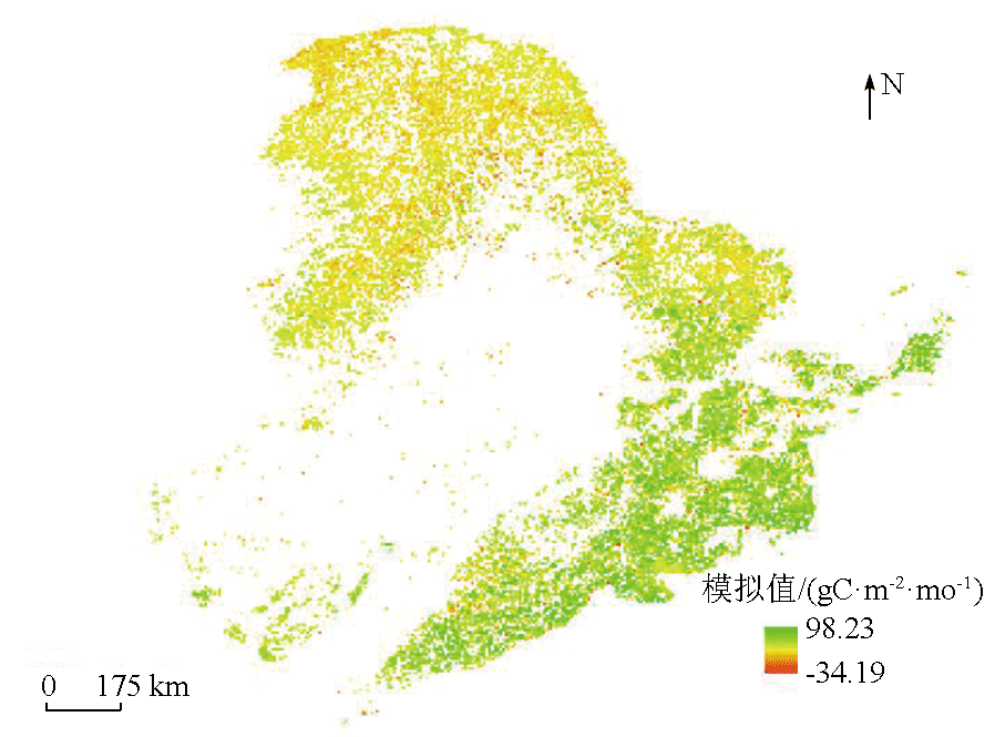
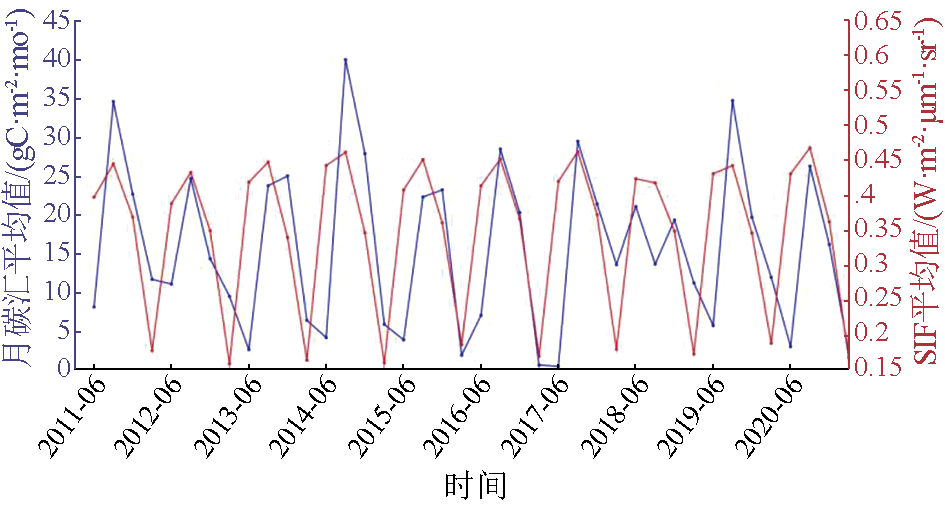
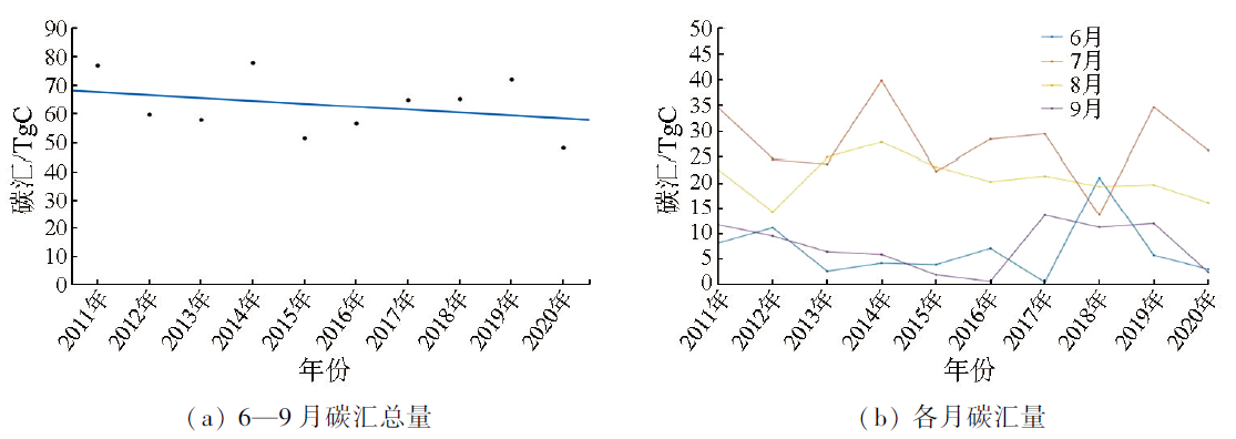
Abstract Forest carbon sink, an important factor in maintaining the ecological balance of the earth and coping with climate change, plays a key role in the global carbon cycle. It absorbs large amounts of carbon dioxide and stores carbon element, helping mitigate climate change. Additionally, forest carbon sink provides essential ecological services, such as biodiversity conservation, water resource regulation, and soil conservation. Therefore, the estimation of forest carbon sink is critical. Based on solar-induced chlorophyll fluorescence (SIF) and using the gross primary productivity (GPP) as an intermediate variable, this study estimated forest carbon sink in the forest region of Northeast China during the vegetation growth period (i.e., from June to September) between 2011 and 2020. The results reveal a strong spatial correlation between forest carbon sink and SIF in this region. The similar distributions of SIF values and carbon sink in the forest region of Northeast China indicate that the Changbai Mountains and the Da Hinggan Mountains had high and low carbon sink capacities, respectively. Over the vegetation growth period from June to September, the carbon sink capacity in the region showed a gradual upward trend initially, followed by a gradual downward trend. Overall, it is highly feasible to estimate carbon sink using SIF in the forest region of Northeast China.
|
| Keywords
forest carbon sink
solar-induced chlorophyll fluorescence (SIF)
gross primary productivity (GPP)
|
|
|
|
Issue Date: 17 February 2025
|
|
|
| [1] |
毕君, 王超, 尤海舟. 基于温室气体清单的河北省森林碳汇量研究[J]. 生态科学, 2016, 35(4):113-118.
|
| [1] |
Bi J, Wang C, You H Z. Forest carbon sequestration estimation based on Greenhouse Gases Inventory in Hebei Province[J]. Ecological Science, 2016, 35(4):113-118.
|
| [2] |
吕富成, 马建勇, 曹云, 等. 基于FORCCHN模型的中国典型森林生态系统碳通量模拟[J]. 生态学报, 2022, 42(7):2810-2821.
|
| [2] |
Lyu F C, Ma J Y, Cao Y, et al. Carbon fluxes simulation of China’s typical forest ecosystem based on FORCCHN model[J]. Acta Ecologica Sinica, 2022, 42(7):2810-2821.
|
| [3] |
梅晓丹, 李丹, 王强, 等. 基于Biome-BGC模型的小兴安岭森林碳通量时空分析[J]. 测绘与空间地理信息, 2021, 44(11):7-10.
|
| [3] |
Mei X D, Li D, Wang Q, et al. Spatial-temporal analysis of forest carbon flux of in Xiaoxing’anling based on biome-BGC model[J]. Geomatics and Spatial Information Technology, 2021, 44(11):7-10.
|
| [4] |
Magney T S, Bowling D R, Logan B A, et al. Mechanistic evidence for tracking the seasonality of photosynthesis with solar-induced fluorescence[J]. Proceedings of the National Academy of Sciences of the United States of America, 2019, 116(24):11640-11645.
doi: 10.1073/pnas.1900278116
pmid: 31138693
|
| [5] |
Wang M, Zhang L. Synchronous changes of GPP and solar-induced chlorophyll fluorescence in a subtropical evergreen coniferous forest[J]. Plants, 2023, 12(11):2224.
|
| [6] |
Frankenberg C, Fisher J B, Worden J, et al. New global observations of the terrestrial carbon cycle from GOSAT:Patterns of plant fluorescence with gross primary productivity[J]. Geophysical Research Letters, 2011, 38(17):L17706.
|
| [7] |
Frankenberg C, O’dell C, Guanter L, et al. Remote sensing of near-infrared chlorophyll fluorescence from space in scattering atmospheres:Implications for its retrieval and interferences with atmospheric CO2 retrievals[J]. Atmospheric Measurement Techniques, 2012, 5(8):2081-2094.
|
| [8] |
Li X, Xiao J, He B, et al. Solar-induced chlorophyll fluorescence is strongly correlated with terrestrial photosynthesis for a wide variety of biomes:First global analysis based on OCO-2 and flux tower observations[J]. Global Change Biology, 2018, 24(9):3990-4008.
|
| [9] |
李月, 孙政国. 基于叶绿素荧光遥感监测的蒙古高原草地生产力时空动态分析[J]. 江苏农业科学, 2021, 49(13):219-226.
|
| [9] |
Li Y, Sun Z G. Temporal and spatial dynamic analysis of grassland productivity in Mongolian Plateau based on chlorophyll fluorescence remote sensing monitoring[J]. Jiangsu Agricultural Sciences, 2021, 49(13):219-226.
|
| [10] |
王雅楠, 韦瑾, 汤旭光, 等. 应用叶绿素荧光估算植被总初级生产力研究进展[J]. 遥感技术与应用, 2020, 35(5):975-989.
doi: 10.11873/j.issn.1004-0323.2020.5.0975
|
| [10] |
Wang Y N, Wei J, Tang X G, et al. Progress of using the chlorophyll fluorescence to estimate terrestrial gross primary production[J]. Remote Sensing Technology and Application, 2020, 35(5):975-989.
|
| [11] |
Li X, Xiao J. A global,0.05-degree product of solar-induced chlorophyll fluorescence derived from OCO-2,MODIS,and reanalysis data[J]. Remote Sensing, 2019, 11(5):517.
|
| [12] |
张心竹, 王鹤松, 延昊, 等. 2001—2018年中国总初级生产力时空变化的遥感研究[J]. 生态学报, 2021, 41(16):6351-6362.
|
| [12] |
Zhang X Z, Wang H S, Yan H, et al. Analysis of spatio-temporal changes of gross primary productivity in China from 2001 to 2018 based on Romote Sensing[J]. Acta Ecologica Sinica, 2021, 41(16):6351-6362.
|
| [13] |
谢鹏飞. 基于日光诱导叶绿素荧光的干旱遥感监测研究[D]. 合肥: 安徽农业大学, 2022.
|
| [13] |
Xie P F. Remote sensing monitoring of drought based on solar-induced chlorophyll fluorescence[D]. Hefei: Anhui Agricultural University, 2022.
|
| [14] |
安映荷, 张润卿, 刘文杰, 等. 海南岛橡胶林区域不同SIF产品的差异性分析及其对GPP估算的影响[J]. 热带生物学报, 2023, 14(4):412-423.
|
| [14] |
An Y H, Zhang R Q, Liu W J, et al. Analysis of different satellite-based SIF products of the rubber plantations in Hainan Island and their effects on GPP estimate[J]. Journal of Tropical Biology, 2023, 14(4):412-423.
|
| [15] |
Liu J, Chen J M, Cihlar J, et al. Net primary productivity mapped for Canada at 1-km resolution[J]. Global Ecology and Biogeography, 2002, 11(2):115-129.
|
| [16] |
周敏. 基于叶绿素荧光的中国植被总初级生产力估算[D]. 兰州: 西北师范大学, 2021.
|
| [16] |
Zhou M. Estimation of gross primary production using sun-induced chlorophyll fluorescence in China[D]. Lanzhou: Northwest Normal University, 2021.
|
| [17] |
姜海梅, 叶昊天, 王若静, 等. 基于MODIS产品的生态系统呼吸模型在内蒙古半干旱草原的验证[J]. 北京大学学报(自然科学版), 2019, 55(6):1029-1037.
|
| [17] |
Jiang H M, Ye H T, Wang R J, et al. A validation study of MODIS-based ecosystem respiration model in a semi-arid grassland of Inner Mongolia[J]. Acta Scientiarum Naturalium Universitatis Pekinensis, 2019, 55(6):1029-1037.
|
| [18] |
Gao Y, Yu G, Yan H, et al. A MODIS-based photosynthetic capacity model to estimate gross primary production in Northern China and the Tibetan Plateau[J]. Remote Sensing of Environment, 2014,148:108-118.
|
| [19] |
Lloyd J, Taylor J A. On the temperature dependence of soil respiration[J]. Functional Ecology, 1994, 8(3):315.
|
| [20] |
闫世琦, 赵正勇, 杨旗, 等. 基于有限样点和大尺度模型的区域土壤呼吸模型研究[J]. 土壤通报, 2021, 52(4):865-872.
|
| [20] |
Yan S Q, Zhao Z Y, Yang Q, et al. Regional soil respiration modelling based on the finite sample points and the large-scale model[J]. Chinese Journal of Soil Science, 2021, 52(4):865-872.
|
| [21] |
马芮. 基于模型—数据融合的中国区域碳水通量动态模拟及分析[D]. 北京: 中国科学院大学(中国科学院遥感与数字地球研究所), 2018.
|
| [21] |
Ma R. Dynamic simulation and analysis of carbon and water fluxes in China based on model-data fusion[D]. Beijing: University of Chinese Academy of Sciences (Institute of Remote Sensing and Digital Earth Chinese Academy of Sciences), 2018.
|
| [22] |
韩艳凤, 江志红, 王冀, 等. 东北地区夏季降水时空变化特征[J]. 气象科技, 2005, 33(2):136-141.
|
| [22] |
Han Y F, Jiang Z H, Wang J, et al. Temporal and spatial characteristics of summer rainfall in Northeast China[J]. Meteorological Science and Technology, 2005, 33(2):136-141.
|
| [23] |
龚强, 汪宏宇, 王盘兴. 东北夏季降水的气候及异常特征分析[J]. 气象科技, 2006, 34(4):387-393.
|
| [23] |
Gong Q, Wang H Y, Wang P X. Analysis of climate and anomaly features of summer precipitation in Northeast China[J]. Meteorological Science and Technology, 2006, 34(4):387-393.
|
| [24] |
张雷. 近50年东北地区夏季降水变化特征[J]. 黑龙江农业科学, 2017(10):15-16,20.
|
| [24] |
Zhang L. Characteristics of summer precipitation variability in Northeast China in recent 50 years[J]. Heilongjiang Agricultural Sciences, 2017(10):15-16,20.
|
|
Viewed |
|
|
|
Full text
|
|
|
|
|
Abstract
|
|
|
|
|
Cited |
|
|
|
|
| |
Shared |
|
|
|
|
| |
Discussed |
|
|
|
|
 2025,
Vol. 37
2025,
Vol. 37
 ), LIANG Ailin(