|
|
 |
|

|
|
|
Time-series monitoring and prediction of tailings dams through neural network-based deep infusion of InSAR and GNSS data |
LYU Linwei1,2( ), WANG Rui1,2(), XU Lintao3, HUANG Shiqiao1, HUANG Shuaishuai4, LIN Min5, HE Yibo6, HE Qian7, YAN Huineng1,2, CHEN Shangbo8 ), WANG Rui1,2(), XU Lintao3, HUANG Shiqiao1, HUANG Shuaishuai4, LIN Min5, HE Yibo6, HE Qian7, YAN Huineng1,2, CHEN Shangbo8 |
1. College of Resources and Civil Engineering,Gannan University of Science and Technology,Ganzhou 341000,China
2. Ganzhou Key Laboratory of Remote Sensing for Resources and Environment,Ganzhou 341000,China
3. CNPC Bohai Oilfield Equipment Manufacturing Co.,Ltd.,Tianjin 300280,China
4. School of Civil and Surveying Engineering,Jiangxi University of Science and Technology,Ganzhou 341000,China
5. Anhui Longqiao Mining Co.,Ltd.,Hefei 230000,China
6. Shanxi Energy Institute,Jinzhong 030600,China
7. Hubei Vocational College of Land and Resources,Wuhan 430090,China
8. Jiangxi Provincial Emergency Management Science Research Institute,Nanchang 330000,China |
|
|
|
|
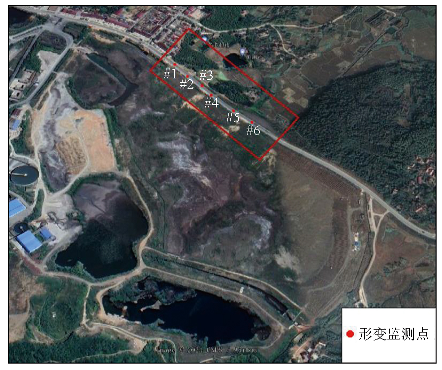
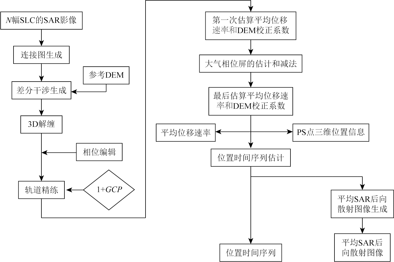
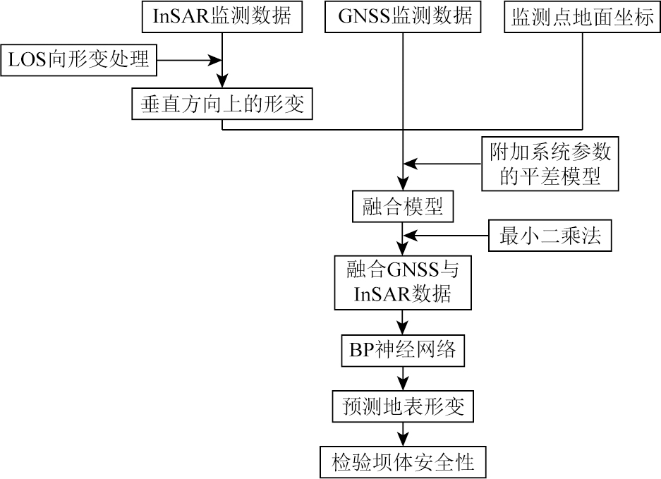
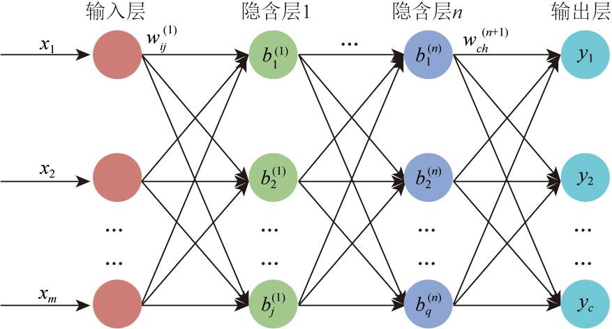
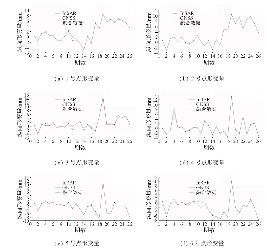
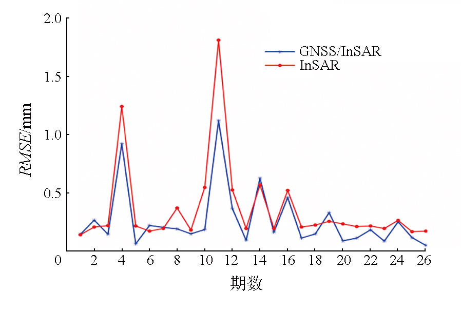
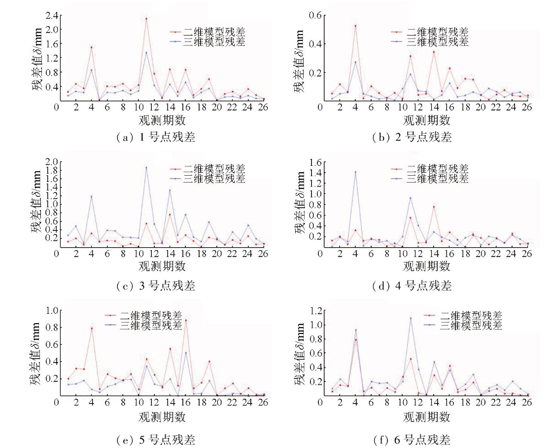
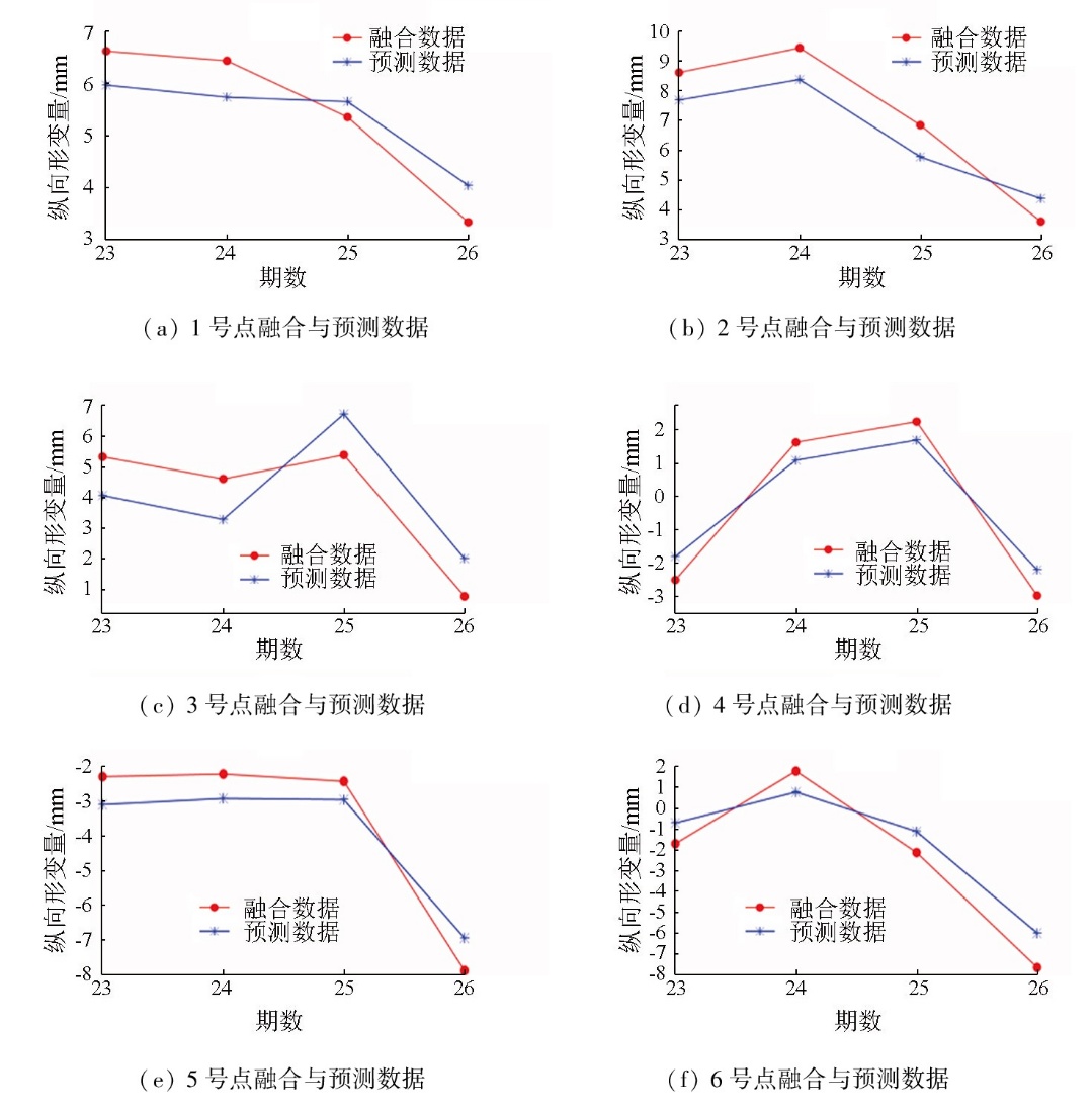
Abstract The time-series monitoring and prediction of tailings dam stability have always been a major concern in China’s mine safety research. Focusing on a tailings dam in Anhui province,this study obtained 26 periods of longitudinal deformation data from six characteristic monitoring points on the dam surface,using InSAR and GNSS technologies. Based on the data,a least-squares adjustment model with restricted parameters was established. Combined with the initial three-dimensional coordinates of the monitoring points as polynomial correction parameters,the InSAR and GNSS data were fused to improve the data accuracy. Then,time-series prediction of deformation data was conducted for the monitoring points using the back propagation (BP) neural network,thus obtaining their future deformation data. Experiments were carried out to compute and compare the deformation data and corresponding root mean square error (RMSE) of each period before and after fusion,wherein the fused GNSS and InSAR data were evaluated with the root mean square error (RMSE) as the accuracy standard. The results showed that the post-fusion RMSE decreased by up to 70.61% and by at least 4.34% (average:25.91%),compared to pre-fusion data. Furthermore,the neural network model was used to repeatedly train the fused InSAR data from periods 1 to 22,with periods 23 to 26 serving as the test set,ultimately outputting the data of each point for periods 23 to 26. Compared to the GNSS data,the RMSE of the outputs were less than 1.5 mm. These results can provide reliable technical support for the time-series monitoring and prediction of tailings dam stability.
|
| Keywords
tailings pond
SBASInSAR
least-squares adjustment model with restricted parameters
back propagation (BP)
|
|
|
|
Issue Date: 28 October 2025
|
|
|
| [1] |
李如仁, 孙加瑶. 融合SBAS-InSAR与GS-LSTM的尾矿库沉降监测与预测[J]. 金属矿山, 2023(1):102-109.
|
| [1] |
Li R R, Sun J Y. Subsidence monitoring and prediction of tailings pond combined with SBAS-InSAR and GS-LSTM[J]. Metal Mine, 2023(1):102-109.
|
| [2] |
马东升. 基于GNSS形变监测技术的尾矿库安全在线监测系统在司家营北区尾矿库的应用[J]. 中国金属通报, 2019(11):140-141.
|
| [2] |
Ma D S. Application of safety online monitoring system of tailings pond based on GNSS deformation monitoring technology in tailings pond in Sijiaying North District[J]. China Metal Bulletin, 2019(11):140-141.
|
| [3] |
陈娅男. 基于时序InSAR尾矿坝(库区)监测及灾害识别[D]. 昆明: 昆明理工大学, 2020.
|
| [3] |
Chen Yanan. Monitoring and disaster identification of tailings dam ( reservoir area ) based on time series InSAR[D]. Kunming: Kunming University of Science and Technology, 2020.
|
| [4] |
朱建军, 杨泽发, 李志伟. InSAR矿区地表三维形变监测与预计研究进展[J]. 测绘学报, 2019, 48(2):135-144.
doi: 10.11947/j.AGCS.2019.20180188
|
| [4] |
Zhu J J, Yang Z F, Li Z W. Recent progress in retrieving and predicting mining-induced 3D displace-ments using InSAR[J]. Acta Geodaetica et Cartographica Sinica, 2019, 48(2):135-144.
doi: 10.11947/j.AGCS.2019.20180188
|
| [5] |
许才军, 王华, 黄劲松. GPS与INSAR数据融合研究展望[J]. 武汉大学学报(信息科学版), 2003, 28(s1):58-61,78.
|
| [5] |
Xu C J, Wang H, Huang J S. Research prospect of data fusion between GPS and INSAR[J]. Geomatics and Information Science of Wuhan University, 2003, 28(s1):58-61,78.
|
| [6] |
刘国林, 张连蓬, 成枢, 等. 合成孔径雷达干涉测量与全球定位系统数据融合监测矿区地表沉降的可行性分析[J]. 测绘通报, 2005(11):10-13.
|
| [6] |
Liu G L, Zhang L P, Cheng S, et al. Feasibility analysis of monitoring mining surface substance using InSAR/GPS data fusion[J]. Bulletin of Surveying and Mapping, 2005(11):10-13.
|
| [7] |
曹海坤, 赵丽华, 张勤, 等. 利用附加系统误差参数的升降轨InSAR-GPS数据融合方法建立三维形变场[J]. 武汉大学学报(信息科学版), 2018, 43(9):1362-1368.
|
| [7] |
Cao H K, Zhao L H, Zhang Q, et al. Ascending and descending orbits InSAR-GPS data fusion method with additional systematic parameters for three-dimensional deformation field[J]. Geomatics and Information Science of Wuhan University, 2018, 43(9):1362-1368.
|
| [8] |
王洲. GNSS与InSAR地面形变监测深度融合[D]. 兰州: 兰州交通大学, 2021.
|
| [8] |
Wang Z. Deep fusion of GNSS and InSAR ground deformation monitoring[D]. Lanzhou: Lanzhou Jiatong University, 2021.
|
| [9] |
熊威, 孙志杰, 张必昌. 升降轨时序InSAR技术监测天津市地面沉降[J]. 地理空间信息, 2021, 19(12):45-49.
|
| [9] |
Xiong W, Sun Z J, Zhang B C. Surface subsidence monitoring in Tianjin based on ascending and descending time series InSAR technology[J]. Geospatial Information, 2021, 19(12):45-49.
|
| [10] |
Memarian Sorkhabi O, Khajehzadeh M, Keawsawasvong S. Landslides monitoring with SBAS-InSAR and GNSS[J]. Physics and Chemistry Earth,Parts A/B/C, 2023, 132:103486.
|
| [11] |
Wang R, Wu K, He Q, et al. A novel method of monitoring surface subsidence law based on probability integral model combined with active and passive remote sensing data[J]. Remote Sensing, 2022, 14(2):299.
|
| [12] |
赵华伟, 周林, 谭明伦, 等. 基于光学遥感和SBAS-InSAR的川渝输电网滑坡隐患早期识别[J]. 自然资源遥感, 2023, 35(4):264-272 doi:10.6046/zrzyyg.2022321.
|
| [12] |
Zhao H W, Zhou L, Tan M L, et al. Early identification of potential landslides for the Sichuan-Chongqing power grid based on optical remote sensing and SBAS-InSAR[J]. Remote Sensing for Natural Resources, 2023, 35(4):264-272 doi:10.6046/zrzyyg.2022321.
|
| [13] |
周定义, 左小清, 赵志芳, 等. 基于SBAS-InSAR和改进BP神经网络的城市地面沉降预测[J]. 地质通报, 2023, 42(10):1774-1783.
|
| [13] |
Zhou D Y, Zuo X Q, Zhao Z F, et al. Prediction of urban land subsidence by SBAS-InSAR and improved BP neural network[J]. Geological Bulletin of China, 2023, 42(10):1774-1783.
|
| [14] |
易邦进, 黄成, 傅涛, 等. 基于SBAS-InSAR 技术的中缅边境山区地质灾害隐患探测[J]. 自然资源遥感, 2023, 35(4):186-191.doi:10.6046/zrzyyg.2022261.
|
| [14] |
Yi B J, Huang C, Fu T, et al. SBAS-InSAR-based detection of geological hazards in alpine gorge areas near the China-Myanmar border[J]. Remote Sensing for Natural Resources, 2023, 35(4):186-191.doi:10.6046/zrzyyg.2022261.
|
| [15] |
刘青利, 隋立芬. 附加系统参数的平差模型研究[J]. 测绘学院学报, 2004, 21(1):5-7,10.
|
| [15] |
Liu Q L, Sui L F. On adjustment model with additional systematic parameters[J]. Journal of Institute of Surveying and Mapping, 2004, 21(1):5-7,10.
|
| [16] |
魏飞, 谭志祥, 邓喀中. 附加系统参数平差在二维控制网平差中的应用[J]. 煤炭技术, 2017, 36(3):139-141.
|
| [16] |
Wei F, Tan Z X, Deng K Z. Application in two-dimensional control network adjustment with additional system parameters adjustment[J]. Coal Technology, 2017, 36(3):139-141.
|
| [17] |
陈映彬, 文逸彦, 董国祥, 等. 基于BP人工神经网络与遗传算法的航速优化[J]. 舰船科学技术, 2024, 46(1):82-87.
|
| [17] |
Chen Y B, Wen Y Y, Dong G X, et al. Speed optimization based on BP artificial neural network and genetic algorithm[J]. Ship Science and Technology, 2024, 46(1):82-87.
|
| [18] |
Guo J, Xi W, Yang Z, et al. Study on optimization method for InSAR baseline considering changes in vegetation coverage[J]. Sensors, 2024, 24(15):4783.
|
| [19] |
张焱飞, 李荣宗, 文逸彦, 等. 基于人工神经网络的实船航行主机能耗预估自学习模型[J]. 上海船舶运输科学研究所学报, 2019, 42(2):34-37.
|
| [19] |
Zhang Y F, Li R Z, Wen Y Y, et al. Self-learning artificial neural network model for pre-estimating ship energy consumption for a voyage[J]. Journal of Shanghai Ship and Shipping Research Institute, 2019, 42(2):34-37.
|
| [20] |
王瑞. 开采沉陷监测多源数据融合技术及应用研究[D]. 徐州: 中国矿业大学, 2022.
|
| [20] |
Wang R. Research on multi-source data fusion technology and its application in mining subsidence monitoring[D]. Xuzhou: China University of Mining and Technology, 2022.
|
|
Viewed |
|
|
|
Full text
|
|
|
|
|
Abstract
|
|
|
|
|
Cited |
|
|
|
|
| |
Shared |
|
|
|
|
| |
Discussed |
|
|
|
|
 2025,
Vol. 37
2025,
Vol. 37