|
|
 |
|

|
|
|
Identifying and monitoring tailings ponds by integrating multi-source geographic data and high-resolution remote sensing images: A case study of Gejiu City, Yunnan Province |
LIU Xiaoliang1,2( ), WANG Zhihua1,2, XING Jianghe3(), ZHOU Rui4, YANG Xiaomei1,2, LIU Yueming1,2, ZHANG Junyao1,2, MENG Dan1,2 ), WANG Zhihua1,2, XING Jianghe3(), ZHOU Rui4, YANG Xiaomei1,2, LIU Yueming1,2, ZHANG Junyao1,2, MENG Dan1,2 |
1. State Key Laboratory of Resources and Environmental Information System, Institute of Geographic Sciences and Natural Resources Research, CAS, Beijing 100101, China
2. University of Chinese Academy of Sciences, Beijing 100049, China
3. College of Geoscience and Surveying Engineering, China University of Mining and Technology(Beijing), Beijing 100083, China
4. Image Sky Beijing Technology Co., Ltd., Beijing 100086, China |
|
|
|
|
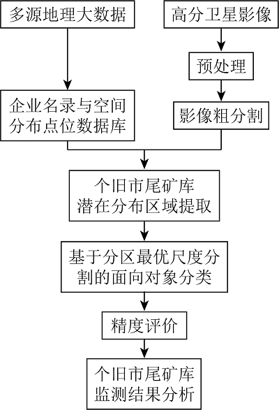
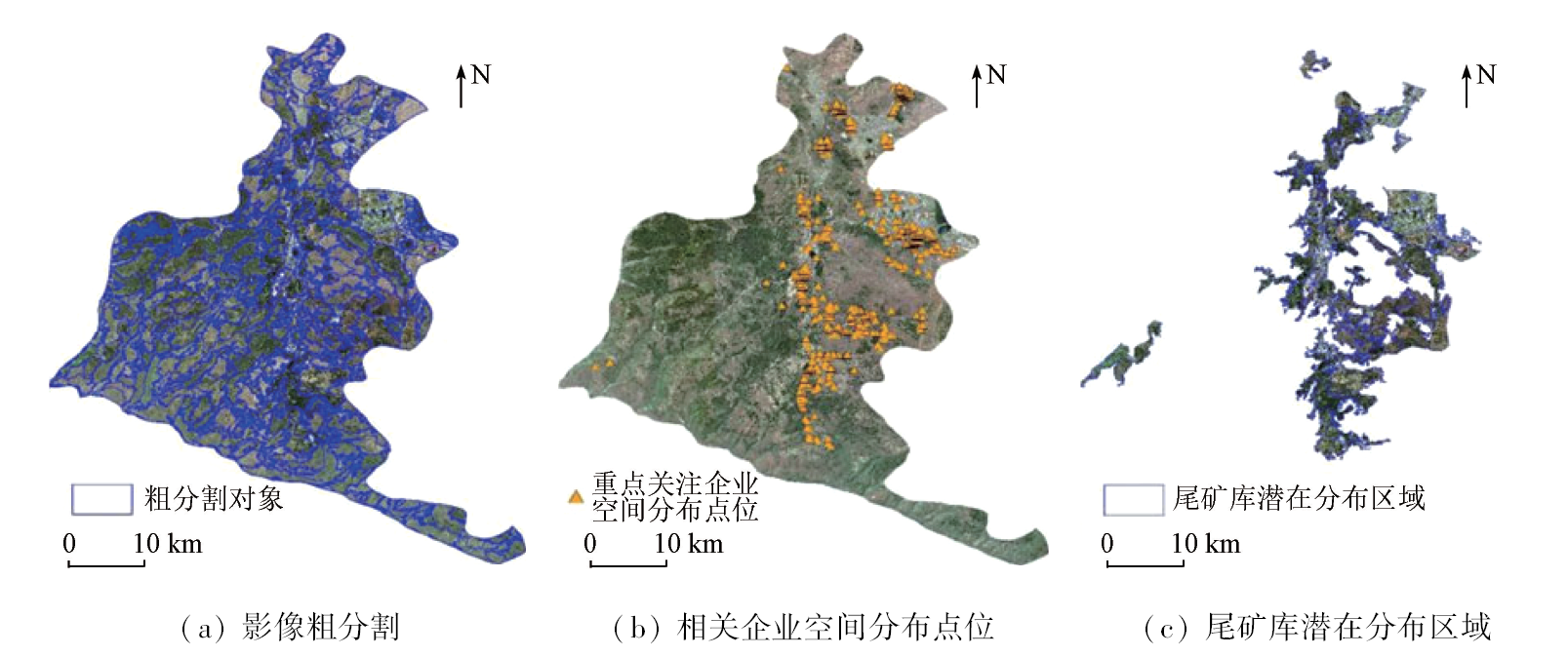
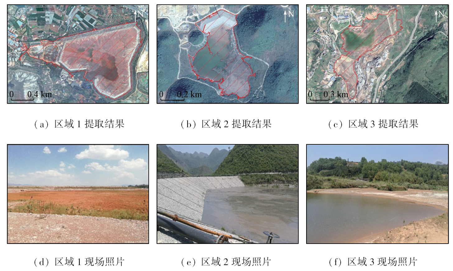
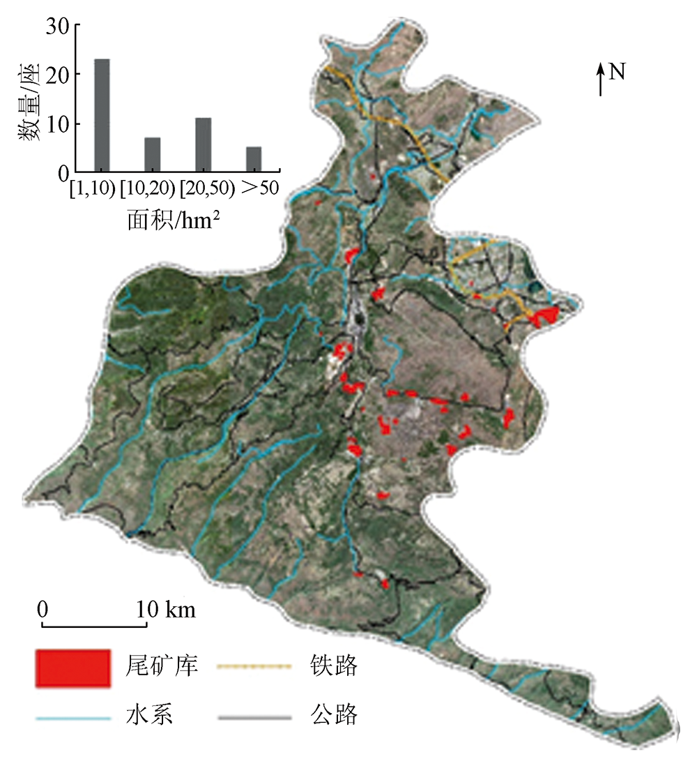
Abstract Tailings ponds are considerable hazard sources with high potential energy. Ascertaining the number and distribution of tailings ponds in a timely manner through rapid identification and monitoring of their spatial extents is critical for the environmental supervision and governance of tailings ponds in China. Due to the lack of pertinence for potential targets, identifying tailings ponds based on solely remote sensing images is prone to produce confusion between tailings ponds and exposed surfaces, resulting in significant errors in practical applications. This study proposed an extraction method for tailings ponds, which integrated enterprise directory, multi-source geographic data (e.g., data from spatial distribution points, digital elevation model (DEM), and road networks), and high-resolution remote sensing images. The application of this method in Gejiu City, Yunnan Province indicates that integrating multi-source geographic data can effectively exclude the interferential areas without tailings ponds, with the precision and recall rates of the extraction results reaching 83.9% and 72.4%, respectively. The method proposed in this study boasts significant application prospects in high-frequency and automated monitoring of tailings ponds nationwide.
|
| Keywords
multi-source geographic data
remote sensing
object-oriented classification
tailings pond
multi-scale segmentation
|
|
|
|
Issue Date: 13 March 2024
|
|
|
| [1] |
陈生水. 尾矿库安全评价存在的问题与对策[J]. 岩土工程学报, 2016, 38(10):1869-1873.
|
| [1] |
Chen S S. Problems and countermeasures of safety evaluation of tailing pond[J]. Chinese Journal of Geotechnical Engineering, 2016, 38(10):1869-1873.
|
| [2] |
Islam K, Murakami S. Global-scale impact analysis of mine tailings dam failures:1915—2020[J]. Global Environmental Change, 2021, 70:102361.
doi: 10.1016/j.gloenvcha.2021.102361
url: https://linkinghub.elsevier.com/retrieve/pii/S0959378021001400
|
| [3] |
王宏洋, 王旭, 陈海燕, 等. 尾矿库环境风险管控相关政策分析及建议[J]. 环境科学研究, 2023, 36(5):1052-1060.
|
| [3] |
Wang H Y, Wang X, Chen H Y, et al. Analysis and suggestions of environmental risk control strategy for tailings ponds[J]. Research of Environmental Sciences, 2023, 36(5):1052-1060.
|
| [4] |
郝利娜, 张志, 何文熹, 等. 鄂东南尾矿库高分辨率遥感图像识别因子研究[J]. 国土资源遥感, 2012, 24(3):154-158.doi:10.6046/gtzyyg.2012.03.27.
|
| [4] |
Hao L N, Zhang Z, He W X, et al. Tailings reservoir recognition factors of the highresolution remote sensing image in southeastern Hubei[J]. Remote Sensing for Land and Resources, 2012, 24(3):154-158.doi:10.6046/gtzyyg.2012.03.27.
|
| [5] |
于博文, 田淑芳, 赵永超, 等. 高分一号卫星在京津矿山遥感监测中的应用[J]. 现代地质, 2017, 31(4):843-850.
|
| [5] |
Yu B W, Tian S F, Zhao Y C, et al. Application of GF-1 satellite in remote sensing monitoring on mine exploitation in Beijing and Tianjin[J]. Geoscience, 2017, 31(4):843-850.
|
| [6] |
高永志, 初禹, 梁伟. 黑龙江省矿集区尾矿库遥感监测与分析[J]. 国土资源遥感, 2015, 27(1):160-163.doi:10.6046/gtzyyg.2015.01.25.
|
| [6] |
Gao Y Z, Chu Y, Liang W. Remote sensing monitoring and analysis of tailings ponds in the ore concentration area of Heilongjiang Pro-vince[J]. Remote Sensing for Land and Resources, 2015, 27(1):160-163.doi:10.6046/gtzyyg.2015.01.25.
|
| [7] |
曹兰杰, 吴兵, 汪金花, 等. 面向对象的高分一号铁尾矿遥感信息提取与分析[J]. 测绘与空间地理信息, 2019, 42(4):98-101.
|
| [7] |
Cao L J, Wu B, Wang J H, et al. Object-oriented information extraction and analysis of the iron tailings with GF-1 remote sensing image[J]. Geomatics and Spatial Information Technology, 2019, 42(4):98-101.
|
| [8] |
范莹琳, 娄德波, 张长青, 等. 基于面向对象的铁尾矿信息提取技术研究——以迁西地区北京二号遥感影像为例[J]. 自然资源遥感, 2021, 33(4):153-161.doi:10.6046/zrzyyg.2021027.
|
| [8] |
Fan Y L, Lou D B, Zhang C Q, et al. Information extraction technologies of iron mine tailings based on object-oriented classification:A case study of Beijing-2 remote sensing images of the Qianxi Area,Hebei Province[J]. Remote Sensing for Natural Resources, 2021, 33(4):153-161.doi:10.6046/zrzyyg.2021027.
|
| [9] |
张成业, 邢江河, 李军, 等. 基于U-Net网络和GF-6影像的尾矿库空间范围识别[J]. 自然资源遥感, 2021, 33(4):252-257.doi:10.6046/zrzyyg.2021017.
|
| [9] |
Zhang C Y, Xing J H, Li J, et al. Recognition of the spatial scopes of tailing ponds based on U-Net and GF-6 images[J]. Remote Sensing for Natural Resources, 2021, 33(4):252-257.doi:10.6046/zrzyyg.2021017.
|
| [10] |
Lyu J J, Hu Y, Ren S L, et al. Extracting the tailings ponds from high spatial resolution remote sensing images by integrating a deep learning-based model[J]. Remote Sensing, 2021, 13(4):743.
doi: 10.3390/rs13040743
url: https://www.mdpi.com/2072-4292/13/4/743
|
| [11] |
闫凯, 沈汀, 陈正超, 等. 基于深度学习的SSD模型尾矿库自动提取[J]. 中国科学院大学学报, 2020, 37(3):360-367.
doi: 10.7523/j.issn.2095-6134.2020.03.009
|
| [11] |
Yan K, Shen T, Chen Z C, et al. Automatic extraction of tailing pond based on SSD of deep learning[J]. Journal of University of Chinese Academy of Sciences, 2020, 37(3):360-367.
doi: 10.7523/j.issn.2095-6134.2020.03.009
|
| [12] |
李庆, 陈俊杰, 李庆亭, 等. 基于SSD模型的京津冀地区尾矿库检测[J]. 遥感技术与应用, 2021, 36(2):293-303.
|
| [12] |
Li Q, Chen J J, Li Q T, et al. Detection of tailings pond in Beijing-Tianjin-Hebei region based on SSD model[J]. Remote Sensing Technology and Application, 2021, 36(2):293-303.
|
| [13] |
Li Q T, Chen Z C, Zhang B, et al. Detection of tailings dams using high-resolution satellite imagery and a single shot multibox detector in the Jing-Jin-Ji region,China[J]. Remote Sensing, 2020, 12(16):2626.
doi: 10.3390/rs12162626
url: https://www.mdpi.com/2072-4292/12/16/2626
|
| [14] |
Ma B D, Chen Y T, Zhang S, et al. Remote sensing extraction method of tailings ponds in ultra-low-grade iron mining area based on spectral characteristics and texture entropy[J]. Entropy, 2018, 20(5):345.
doi: 10.3390/e20050345
url: http://www.mdpi.com/1099-4300/20/5/345
|
| [15] |
Hao L N, Zhang Z, Yang X X. Mine tailing extraction indexes and model using remote-sensing images in southeast Hubei Province[J]. Environmental Earth Sciences, 2019, 78(15):493.
doi: 10.1007/s12665-019-8439-1
|
| [16] |
张继贤, 顾海燕, 鲁学军, 等. 地理国情大数据研究框架[J]. 遥感学报, 2016, 20(5):1017-1026.
|
| [16] |
Zhang J X, Gu H Y, Lu X J, et al. Research framework of geographical conditions and big data[J]. Journal of Remote Sensing, 2016, 20(5):1017-1026.
|
| [17] |
Liao C, Brown D, Fei D, et al. Big data-enabled social sensing in spatial analysis:Potentials and pitfalls[J]. Transactions in GIS, 2018, 22(6):1351-1371.
doi: 10.1111/tgis.v22.6
url: https://onlinelibrary.wiley.com/toc/14679671/22/6
|
| [18] |
Liu X P, He J L, Yao Y, et al. Classifying urban land use by integrating remote sensing and social media data[J]. International Journal of Geographical Information Science, 2017, 31(8):1675-1696.
doi: 10.1080/13658816.2017.1324976
url: https://www.tandfonline.com/doi/full/10.1080/13658816.2017.1324976
|
| [19] |
赵云涵, 陈刚强, 陈广亮, 等. 耦合多源大数据提取城中村建筑物——以广州市天河区为例[J]. 地理与地理信息科学, 2018, 34(5):7-13,1.
|
| [19] |
Zhao Y H, Chen G Q, Chen G L, et al. Integrating multi-source big data to extract buildings of urban villages:A case study of Tianhe District,Guangzhou[J]. Geography and Geo-Information Science, 2018, 34(5):7-13,1.
|
| [20] |
李闽, 杨耀红. 个旧市矿产资源开发环境代价核算[J]. 中国人口·资源与环境, 2013, 23(s2):396-399.
|
| [20] |
Li M, Yang Y H. A preliminary discussion of environment cost caused by mineral resource exploitation in Gejiu City[J]. China Population,Resources and Environment, 2013, 23(s2):396-399.
|
| [21] |
Zheng B B, Wang J H, Feng T T, et al. Risk evolution study of tailings dam failures disaster based on DEMATEL-MISM[J]. Frontiers in Earth Science, 2022, 10:906486.
doi: 10.3389/feart.2022.906486
url: https://www.frontiersin.org/articles/10.3389/feart.2022.906486/full
|
| [22] |
Fennell J, Arciszewski T J. Current knowledge of seepage from oil sands tailings ponds and its environmental influence in northeastern Alberta[J]. Science of the Total Environment, 2019, 686:968-985.
doi: 10.1016/j.scitotenv.2019.05.407
|
|
Viewed |
|
|
|
Full text
|
|
|
|
|
Abstract
|
|
|
|
|
Cited |
|
|
|
|
| |
Shared |
|
|
|
|
| |
Discussed |
|
|
|
|
 2024,
Vol. 36
2024,
Vol. 36