|
|
|
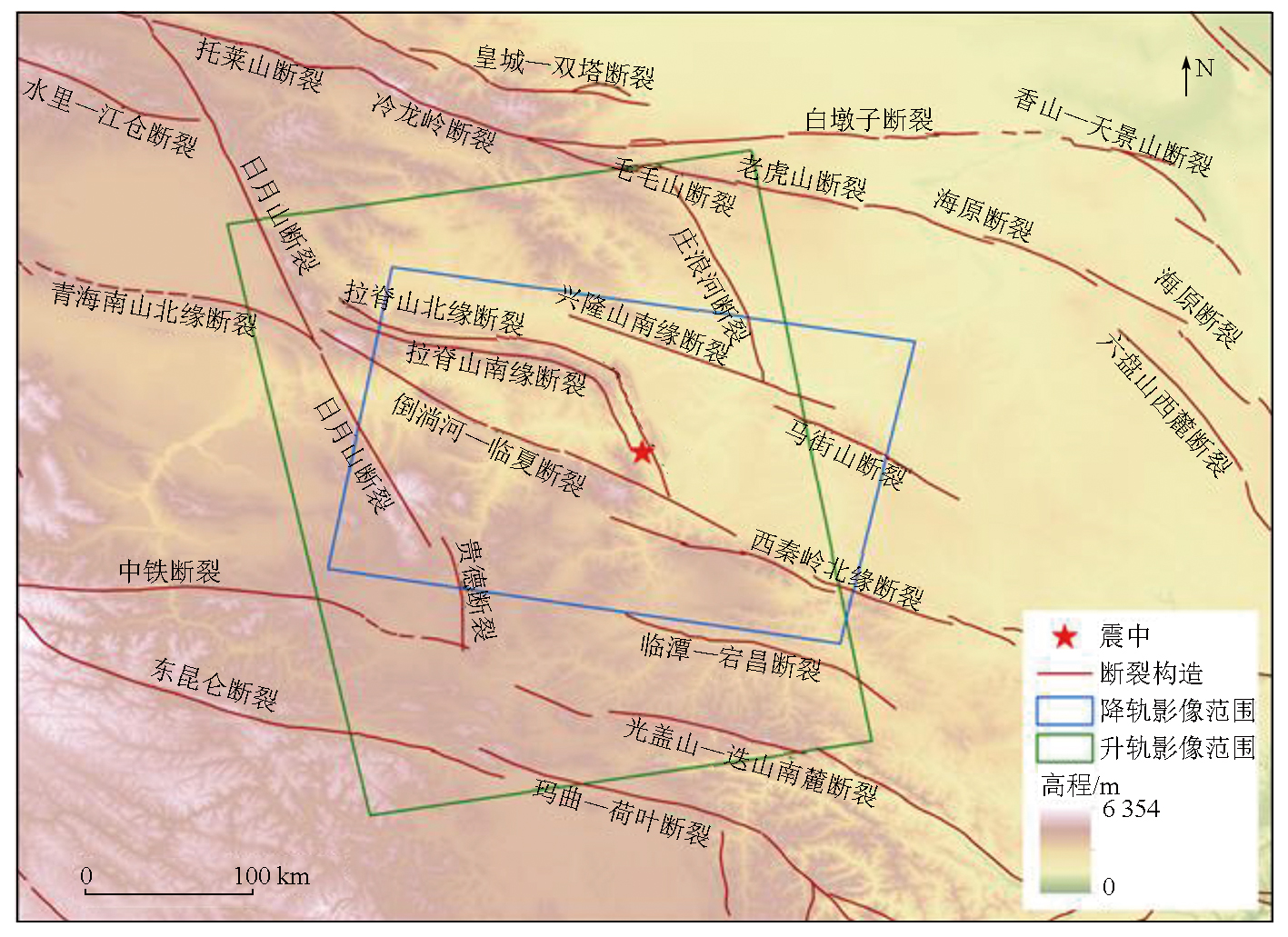
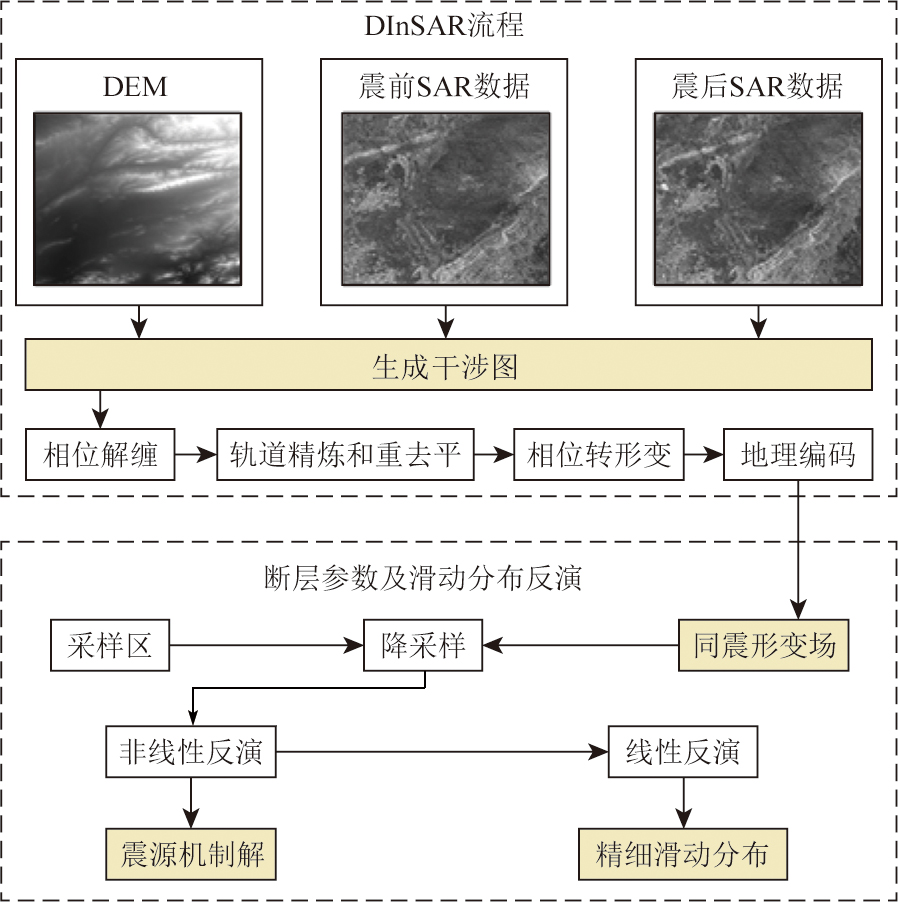
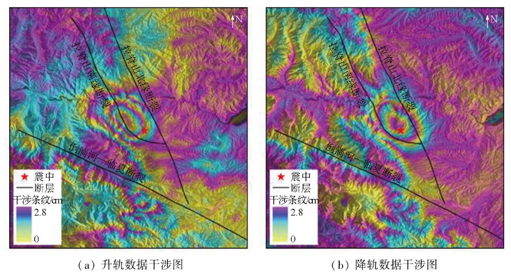
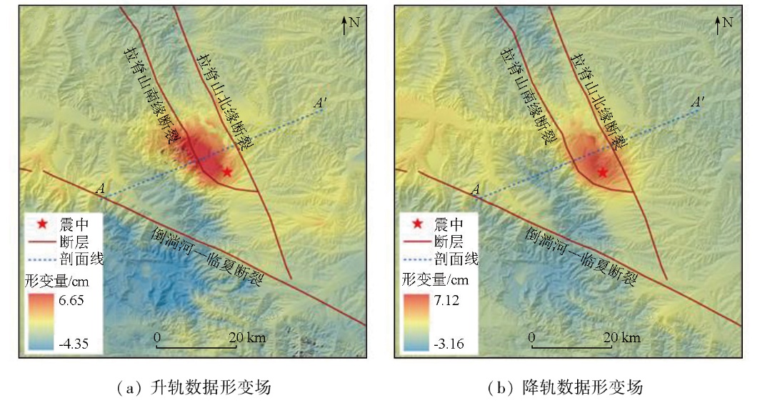
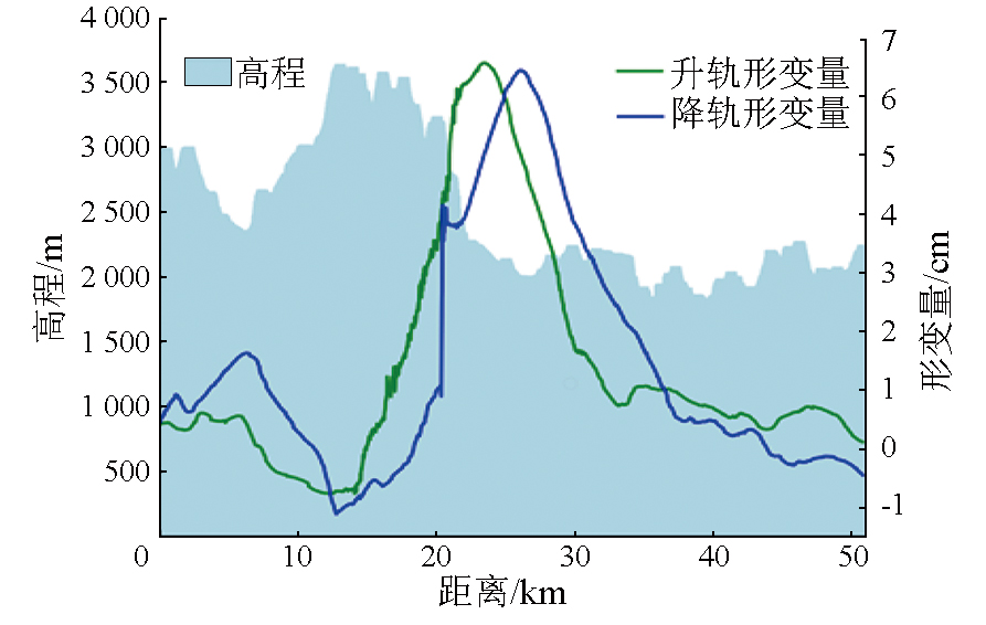
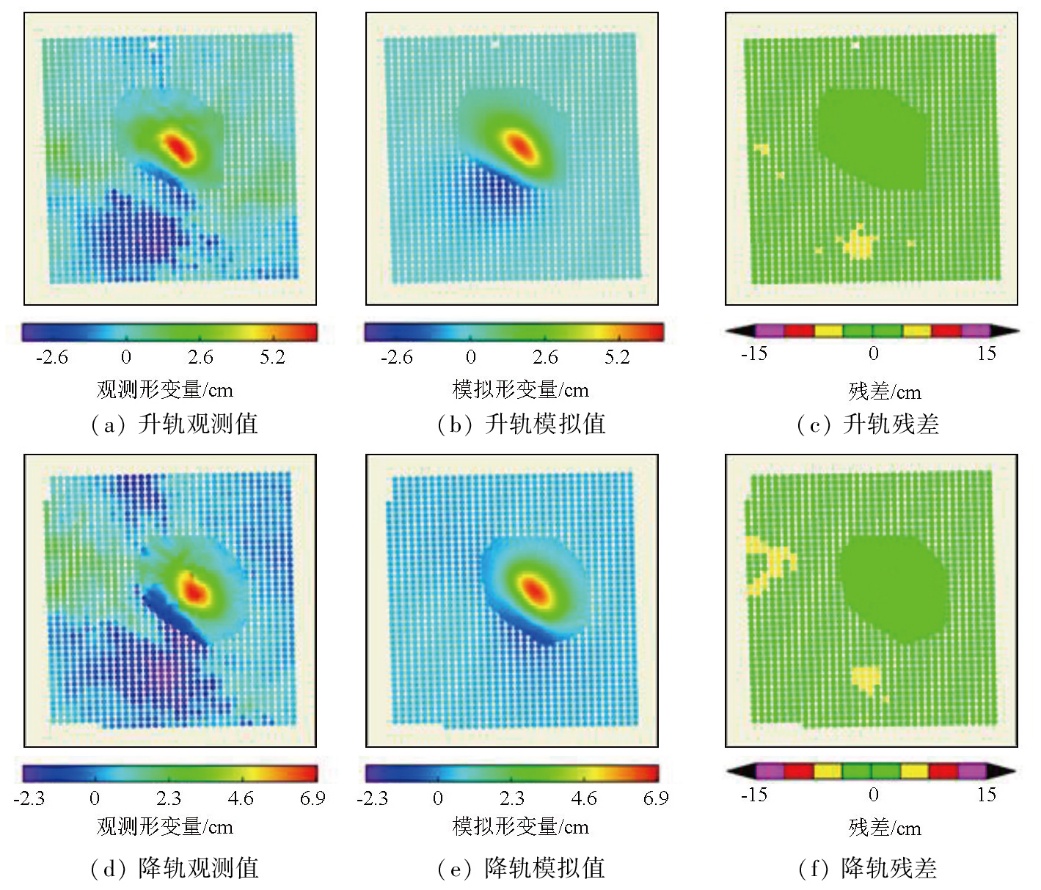
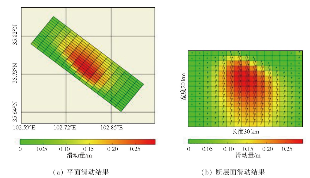
Abstract On December 18,2023,a M6.2 earthquake struck Jishishan Bonan,Dongxiang,and Salar Autonomous County,Gansu Province,China,with a maximum seismic intensity of VIII,causing severe environmental damage. This study aims to determine the basic parameters of the seismogenic fault and analyze its movement. To this end,this study,based on the two-pass differential interferometric synthetic aperture radar (D-InSAR) technique,obtained the coseismic deformation field of this earthquake using ascending and descending orbit from the Sentinel-1A satellite,as well as digital elevation model (DEM) data before and after the earthquake. Based on the dislocation theory in a homogeneous elastic half-space (the Okada dislocation model),a mapping model was established to link coseismic deformation and fault movement. The coseismic deformation field was used to fit the seismogenic fault,followed by the inversion for basic parameters of the seismogenic fault and the simulation of fault slip distribution. The results show that the maximum deformation from the ascending orbit data was about 6.65 cm,while that from the descending orbit data was about 7.12 cm. The seismogenic fault exhibited a strike of 308.14°,a dip angle of 61.57°,and a slip angle of 71.42°. Moreover,the fault presented a maximum slip of approximately 0.29 m located approximately 8 m below the surface and a moment magnitude of Mw6.17. The fault is characterized by thrust movement,with a minor left-lateral strike-slip movement. Based on the regional geological structure,the seismogenic fault is speculated to be the southern margin fault of Laji Mountain,with surface rupture caused by the earthquake.
|
| Keywords
Jishishan earthquake
coseismic deformation
interferometric synthetic aperture radar (InSAR)
seismogenic fault
|
|
|
|
Issue Date: 28 October 2025
|
|
|
| [1] |
陆诗铭, 吴中海, 李智超. 2023年12月18日甘肃省积石山6.2级地震的控震构造及特征[J]. 地震科学进展, 2024, 54(1):86-93.
|
| [1] |
Lu S M, Wu Z H, Li Z C. Seismic structure characteristics of the 18 December 2023 M6.2 Jishishan earthquake,Gansu Province[J]. Progress in Earthquake Sciences, 2024, 54(1):86-93.
|
| [2] |
郭祥云, 韩立波, 张旭, 等. 2023年12月18日甘肃积石山6.2级地震震源参数和破裂特征[J]. 地震科学进展, 2024, 54(1):75-85.
|
| [2] |
Guo X Y, Han L B, Zhang X, et al. Source parameters and rupture characteristics of the M6.2 Jishishan earthquake in Gansu Province on December 18,2023[J]. Progress in Earthquake Sciences, 2024, 54(1):75-85.
|
| [3] |
王润妍, 万永革, 宋泽尧, 等. 2023年12月18日甘肃积石山6.2级地震震源机制及其对周围区域的应力影响[J]. 地震, 2024, 44(1):175-184.
|
| [3] |
Wang R Y, Wan Y G, Song Z Y, et al. Focal mechanism and stress implication on the surrounding region of the Jishishan,Gansu MS 6.2 earthquake on December 18,2023[J]. Earthquake, 2024, 44(1):175-184.
|
| [4] |
杨彦明, 苏淑娟. 2023年甘肃积石山MS 6.2地震:一次逆冲为主的浅源强震[J]. 地震, 2024, 44(1):167-174.
|
| [4] |
Yang Y M, Su S J. The 2023 Jishishan MS 6.2 earthquake in Gansu Province,China:A shallow strong earthquake with thrust-dominated components[J]. Earthquake,2024, 44(1):167-174.
|
| [5] |
王勤彩, 罗钧, 陈翰林, 等. 2023年12月18日甘肃积石山6.2级地震震源机制解[J]. 地震, 2024, 44(1):185-188.
|
| [5] |
Wang Q C, Luo J, Chen H L, et al. Focal mechanism for the December 18,2023,Jishishan MS 6.2 earthquake in Gansu Province[J]. Earthquake, 2024, 44(1):185-188.
|
| [6] |
方楠, 孙凯, 黄传超, 等. 联合InSAR和地震波数据反演甘肃积石山MS 6.2地震震源时空破裂过程[J]. 武汉大学学报(信息科学版), 2025, 50(2):333-343.
|
| [6] |
Fang N, Sun K, Huang C C, et al. Joint inversion of InSAR and seismic data for the kinematic rupture process of the 2023 MS 6.2 Jishishan(Gansu,China) earthquake[J]. Geomatics and Information Science of Wuhan University, 2025, 50(2):333-343.
|
| [7] |
杨九元, 温扬茂, 许才军. InSAR观测揭示的2023年甘肃积石山MS 6.2地震发震构造[J]. 武汉大学学报, 2025, 50(2):313-321.
|
| [7] |
Yang J Y, Wen Y M, Xu C J. Seismogenic fault structure of the 2023 MS 6.2 Jishishan(Gansu,China)earthquake revealed by InSAR observations[J]. Geomatics and Information Science of Wuhan University, 2025, 50(2):313-321.
|
| [8] |
张文婷, 季灵运, 陈玉鑫, 等. 2023年甘肃积石山6.2级地震区域地壳形变特征分析[J]. 武汉大学学报(信息科学版), 2025, 50(2):391-403.
|
| [8] |
Zhang W T, Ji L Y, Chen Y X, et al. Analysis of crustal deformation of the 2023 MS 6.2 Jishishan earthquake in Gansu Province[J]. Geomatics and Information Science of Wuhan University, 2025, 50(2):391-403.
|
| [9] |
李雨森, 李为乐, 许强, 等. 2023年积石山MS 6.2级地震InSAR同震形变探测与断层滑动分布反演[J]. 成都理工大学学报(自然科学版), 2024, 51(1):22-32,75.
|
| [9] |
Li Y S, Li W L, Xu Q, et al. Coseismic deformation and slip distribution of the 2023 Jishishan MS 6.2 earthquake revealed by InSAR observations[J]. Journal of Chengdu University of Technology (Science & Technology Edition), 2024, 51(1):22-32,75.
|
| [10] |
张军龙, 徐岳仁, 李文巧, 等. 中强地震发震构造标志浅析——以2023年积石山MS 6.2地震为例[J]. 地震, 2024, 44(1):226-234.
|
| [10] |
Zhang J L, Xu Y R, Li W Q, et al. Analysis of the markers of seismic structures for moderate earthquakes:A case study of the 2023 Jishishan MS 6.2 earthquake[J]. Earthquake, 2024, 44(1):226-234.
|
| [11] |
Hirose H, Hirahara K, Kimata F, et al. A slow thrust slip event following the two 1996 Hyuganada Earthquakes beneath the Bungo Channel,southwest Japan[J]. Geophysical Research Letters, 1999, 26(21):3237-3240.
|
| [12] |
Jin Z, Fialko Y, Zubovich A, et al. Lithospheric deformation due to the 2015 M7.2 sarez (Pamir) earthquake constrained by 5 years of space geodetic observations[J]. Journal of Geophysical Research:Solid Earth, 2022, 127(4):e2021JB022461.
|
| [13] |
Jin Z, Fialko Y. Coseismic and early postseismic deformation due to the 2021 M7.4 Maduo (China) earthquake[J]. Geophysical Research Letters, 2021, 48(21):e2021GL095213.
|
| [14] |
Massonnet D, Rossi M, Carmona C, et al. The displacement field of the Landers earthquake mapped by radar interferometry[J]. Nature, 1993, 364(6433):138-142.
|
| [15] |
Zebker H A, Rosen P A, Goldstein R M, et al. On the derivation of coseismic displacement fields using differential radar interferometry:The Landers earthquake[J]. Journal of Geophysical Research:Solid Earth, 1994, 99(B10):19617-19634.
|
| [16] |
Lakhote A, Thakkar M G, Kandregula R S, et al. Estimation of active surface deformation in the eastern Kachchh region,western India:Application of multi-sensor DInSAR technique[J]. Quaternary International, 2021, 575:130-140.
|
| [17] |
Carboni F, Porreca M, Valerio E, et al. Surface ruptures and off-fault deformation of the October 2016 central Italy earthquakes from DInSAR data[J]. Scientific Reports, 2022, 12(1):3172.
doi: 10.1038/s41598-022-07068-9
pmid: 35210512
|
| [18] |
屈春燕, 左荣虎, 单新建, 等. 尼泊尔MW 7.8地震InSAR同震形变场及断层滑动分布[J]. 地球物理学报, 2017, 60(1):151-162.
doi: 10.6038/cjg20170113
|
| [18] |
Qu C Y, Zuo R H, Shan X J, et al. Coseismic deformation field of the Nepal MS 8.1 earthquake from Sentinel-1A/InSAR data and fault slip inversion[J]. Chinese Journal of Geophysics, 2017, 60(1):151-162.
|
| [19] |
王守文, 季灵运, 朱良玉, 等. 基于InSAR技术监测2021年青海玛多Mw 7.4级地震同震形变场与断层滑动[J]. 地球科学与环境学报, 2022, 44(6):1016-1026.
|
| [19] |
Wang S W, Ji L Y, Zhu L Y, et al. Co-seismic deformation field and fault slip distribution of the 2021 Maduo Mw 7.4 earthquake in Qinghai,China based on InSAR technology[J]. Journal of Earth Sciences and Environment, 2022, 44(6):1016-1026.
|
| [20] |
Qiu J, Ji L, Zhu L, et al. The June 2022 Khost earthquake in southeastern Afghanistan:A complicated shallow slip event revealed with InSAR[J]. Geodesy and Geodynamics, 2023, 14(6):559-565.
|
| [21] |
刘振江, 韩炳权, 能懿菡, 等. InSAR观测约束下的2023年甘肃积石山地震震源参数及其滑动分布[J]. 武汉大学学报(信息科学版), 2025, 50(2):344-355.
|
| [21] |
Liu Z J, Han B Q, Nai Y H. Source parameters and slip distribution of the 2023 Mw 6.0 Jishishan(Gansu,China) earthquake constrained by InSAR observations[J]. Geomatics and Information Science of Wuhan University, 2025, 50(2):344-355.
|
| [22] |
陈鹏, 邱梁才, 姚宜斌, 等. 基于InSAR和光学影像解译的2023年甘肃积石山MS 6.2震后地表形变和灾害分析[J]. 武汉大学学报(信息科学版), 2025, 50(2):257-270.
|
| [22] |
Chen P, Qiu L C, Yao Y B, et al. Surface deformation and hazard analysis after the 2023 MS 6.2 earthquake in Jishishan,Gansu Province based on InSAR and optical imagery interpretation[J]. Geomatics and Information Science of Wuhan University, 2025, 50(2):257-270.
|
| [23] |
王二七, 张旗, Clark B B. 青海拉鸡山:一个多阶段抬升的构造窗[J]. 地质科学, 2000, 35(4):493-500.
|
| [23] |
Wang E Q, Zhang Q, Burchfiel C. The lajishan fault belt in Qinghai Province:A multi-staged uplifting structural window[J]. Scientia Geologica Sinica, 2000, 35(4):493-500.
|
| [24] |
袁道阳, 张培震, 雷中生, 等. 青海拉脊山断裂带新活动特征的初步研究[J]. 中国地震, 2005, 21(1):93-102.
|
| [24] |
Yuan D Y, Zhang P Z, Lei Z S, et al. A preliminary study on the new activity features of the Lajishan Mountain fault zone in Qinghai Province[J]. Earthquake Research in China, 2005, 21(1):93-102.
|
| [25] |
滕瑞增, 金瑶泉, 李西候, 等. 西秦岭北缘断裂带新活动特征[J]. 西北地震学报, 1994, 16(2):85-90.
|
| [25] |
Teng R Z, Jin Y Q, Li X H, et al. Recent activity characteristis of the fault zone at northern edge of western Qinling MT[J]. China Earthquake Engineering Journal, 1994, 16(2):85-90.
|
| [26] |
Tong X, Xu X, Chen S. Coseismic slip model of the 2021 Maduo earthquake,China from sentinel-1 InSAR observation[J]. Remote Sensing, 2022, 14(3):436.
|
| [27] |
袁道阳. 青藏高原东北缘晚新生代以来的构造变形特征与时空演化[D]. 北京: 中国地震局地质研究所, 2003.
|
| [27] |
Yuan D Y. Tectonic deformation features and space-time evolution in northeastern margin of the Qinghai-Tibetan Plateau since the late cenozoic time[D]. Beijing: Institute of Geology,Seismological Bureau of China, 2003.
|
|
Viewed |
|
|
|
Full text
|
|
|
|
|
Abstract
|
|
|
|
|
Cited |
|
|
|
|
| |
Shared |
|
|
|
|
| |
Discussed |
|
|
|
|
 2025,
Vol. 37
2025,
Vol. 37
 ), LI Sheng1(