|
|
 |
|

|
|
|
Research on coseismic deformation in Ukraine River Valley of Tianshan Mountains based on InSAR technology |
Dong WANG1,2, Fengbing LAI1,2( ), Mengyu CHEN3, Shujiang CHEN1,2, Tiecheng HUANG1,2, Xiang JIA1,2 ), Mengyu CHEN3, Shujiang CHEN1,2, Tiecheng HUANG1,2, Xiang JIA1,2 |
1.College of Geographical Science and Tourism, Xinjiang Normal University, Urumqi 830054,China
2.Urumqi Institute of Spatial Remote Sensing Applications, Urumqi 830025, China
3.School of Foreign Languages, Suzhou University of Science and Technology, Suzhou 215009, China |
|
|
|
|
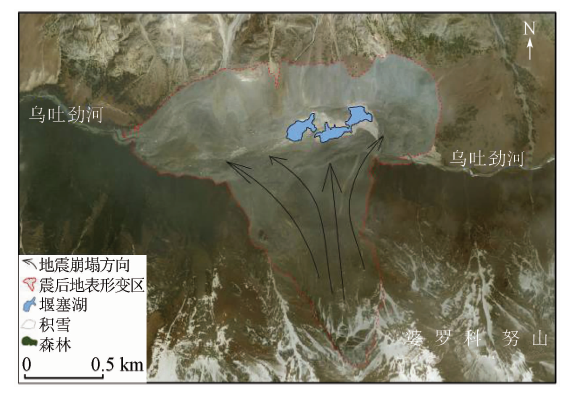
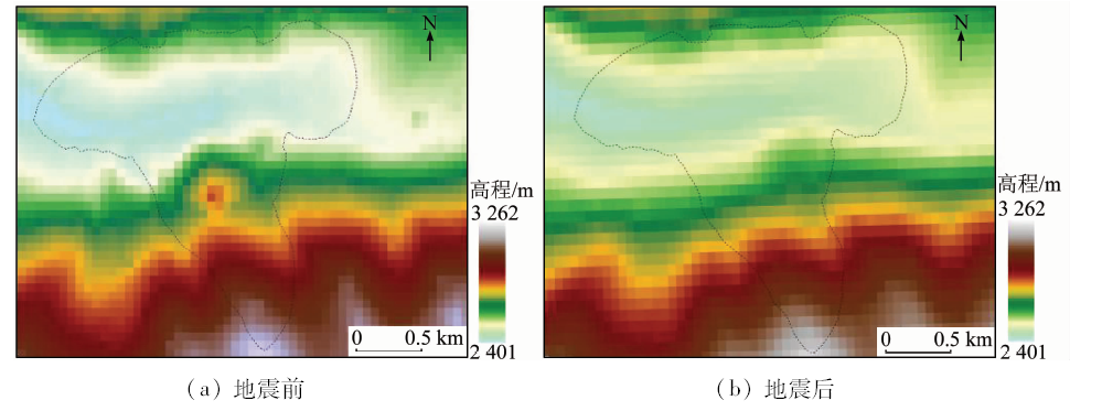
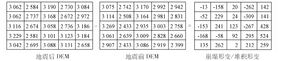
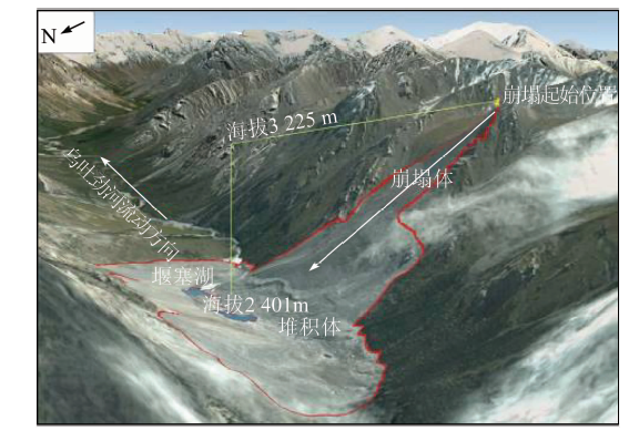
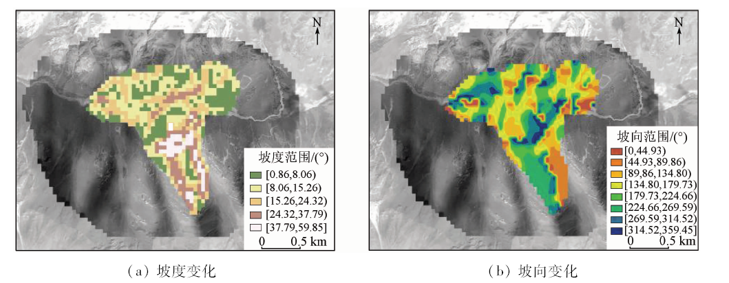
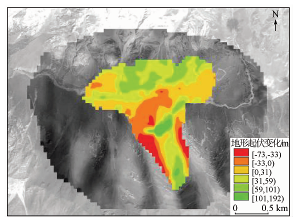
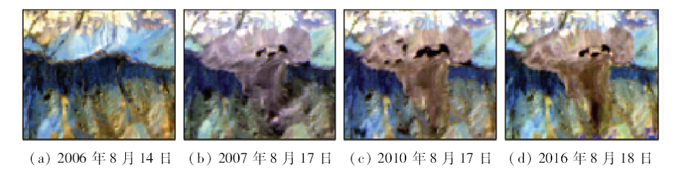
Abstract In this paper, the authors studied the coseismic deformation in Ukraine River valley in Tianshan Mountains, and reconstructed digital elevation modle (DEM) graph of 12.5 m spatial resolution for the study area before and after the earthquake using the ALOS / PALSAR data by InSAR remote sensing technique. Then the authors obtained the remote sensing characteristics of seismic collapse of earthquake by difference method of the DEM after the field verification by RTK calibration. The results show that: ①The area of the collapse of the triangle is 104.47 million m 2, the collapse is 1 416.60 million m 3, the starting elevation is 3 225 m, the average slope is 48°, and slope direction is NNW. ②The trumpet-shaped accumulation body area is 78.61 million m 2, the accumulation is 1 424.27 million m 3, and the buried depth is between 35 m and 80 m. ③The river bed was pushed northward by 100 m, and the eastward advance reached 300 m, due to the accumulation body of the south of the river channel. ④Collapse of the body led to the the formation of quake river. The surface area of the lake increased from 0.039 km 2 to 0.059 km 2 within 30 days and the lake area reached the peak of 0.146 km 2 in 2010. ⑤The factors responsible for the collapse included not only seismic activity but also limestone lithology, terrain slope, fault structure and other comprehensive factors.
|
| Keywords
InSAR
coseismic deformation
Tianshan Mountains
remote sensing
dammed lake
|
|
|
|
Corresponding Authors:
Fengbing LAI
E-mail: laifengbing@163.com
|
|
Issue Date: 14 March 2019
|
|
|
| [1] |
章鑫, 杜学彬, 王丽 , 等. 南北地震带大地电流分布与地震活动关系探讨[J]. 地学前缘, 2017,24(2):202-211.
doi: 10.13745/j.esf.2017.02.019
url: http://d.wanfangdata.com.cn/Periodical/dxqy201702020
|
| [1] |
Zhang X, Du X B, Wang L , et al. The spatial distribution of telluric currents and its relationship with earthquake activities in North-South Seismic Belt[J]. Earth Science Frontiers, 2017,24(2):202-211.
|
| [2] |
张钰, 陈晓清, 游勇 , 等. 汶川地震后肖家沟泥石流活动特征与灾害防治[J]. 水土保持通报, 2014,34(5):284-289.
url: http://d.wanfangdata.com.cn/Periodical/stbctb201405055
|
| [2] |
Zhang Y, Chen X Q, You Y , et al. Activity characteristics and disaster control of Xiaojia Gully debris flow after Wenchuan earthquake[J]. Bulletin of Soil and Water Conservation, 2014,34(5):284-289.
|
| [3] |
石振明, 郑鸿超, 彭铭 , 等. 考虑不同泄流槽方案的堰塞坝溃决机理分析——以唐家山堰塞坝为例[J]. 工程地质学报, 2016,24(5):741-751.
doi: 10.13544/j.cnki.jeg.2016.05.003
url: http://d.wanfangdata.com.cn/Periodical/gcdzxb201605004
|
| [3] |
Shi Z M, Zheng H C, Peng M , et al. Breaching mechanism analysis of landslide dams considering different spillway schemes:A case study of Tangjiashan landslide dam[J]. Journal of Engineering Geo-logy, 2016,24(5):741-751.
|
| [4] |
陈丹蕾, 刘国祥, 王晓文 , 等. 基于DInSAR技术与断层自动剖分方法反演断层滑动参数[J]. 国土资源遥感, 2016,28(3):25-0.doi: 10.6046.gtzyyg.2016.03.05.
doi: 10.6046/gtzyyg.2016.03.05
url: http://www.cqvip.com/QK/91397X/201603/669995278.html
|
| [4] |
Chen D L, Liu G X, Wang X W , et al. Inversion of fault slip parameters based on DInSAR and automated fault model discretization method[J]. Remote Sensing for Land and Resources, 2016,28(3):25-30.doi: 10.6046.gtzyyg.2016.03.05.
|
| [5] |
O’Connor J E, Costa J E . The World’s Largest Floods,Past and Present:Their Causes and Magnitudes[M]. U.S.Geological Survey, 2004: 1-13.
|
| [6] |
Montgomery D R, Hallet B, Liu Y P , et al. Evidence for Holocene mega floods down the Tsangpo River gorge,Southeastern Tibet[J]. Quaternary Research, 2004,62(2):201-207.
doi: 10.1016/j.yqres.2004.06.008
url: https://www.cambridge.org/core/product/identifier/S003358940002682X/type/journal_article
|
| [7] |
赵峰 . 多平台时序InSAR技术的地表形变联合监测方法研究[D]. 徐州:中国矿业大学, 2016.
|
| [7] |
Zhao F . Study on the Method of Multi-platform SAR Data Sets and MTInSAR Technique Based Ground Deformation Monitoring[D]. Xuzhou:China University of Mining and Technology, 2016.
|
| [8] |
雍琦 . InSAR和GPS大地测量形变数据反演地震断层滑动的影响特征研究[D]. 成都:西南交通大学, 2017.
|
| [8] |
Yong Q . Research on Characteristics of Inversion for Earthquake Fault Slip Constrained by InSAR and GPS Geodetic Deformation Data[D]. Chengdu:Southwest Jiaotong University, 2017.
|
| [9] |
Mckillop R J, Clague J J . Statistical remote sensing-based appro-ach for estimating the probability of catastrophic drainage from moraine-dammed lakes in southwestern British Columbia[J]. Global and Planetary Change, 2007,56(1-2):153-171.
doi: 10.1016/j.gloplacha.2006.07.004
url: https://linkinghub.elsevier.com/retrieve/pii/S0921818106001639
|
| [10] |
王治华, 徐起德 . 西藏帕里湖卫星遥感监测[J]. 山地学报, 2009,27(2):240-247.
doi: 10.3969/j.issn.1008-2786.2009.02.015
url: http://www.cnki.com.cn/Article/CJFDTOTAL-SDYA200902017.htm
|
| [10] |
Wang Z H, Xu Q D . Satellite remote sensing monitoring for Pali Lake of Tibet,China[J]. Mountain Research, 2009,27(2):240-247.
|
| [11] |
范建容, 田兵伟, 程根伟 , 等. 基于多源遥感数据的5·12汶川地震诱发堰塞体信息提取[J]. 山地学报, 2008,26(3):257-262.
doi: 10.3969/j.issn.1008-2786.2008.03.001
url: http://www.cqvip.com/QK/71135X/201107/27662374.html
|
| [11] |
Fan J R, Tian B W, Cheng G W , et al. Investigation on damming object induced by the earthquake of Wenchuan on May 12 based on multi-platform remote sensing[J]. Mountain Research, 2008,26(3):257-262.
|
| [12] |
殷幼松 . 高相干分布式目标应用于时间序列InSAR技术监测地表形变研究[D]. 北京:中国测绘科学研究院, 2016.
|
| [12] |
Yin Y S . Highly-coherence Distributed Scatterer Time-series InSAR and Its Application to Monitoring Ground Deformation[D]. Beijing:Chinese Academy of Surveying and Mapping, 2016.
|
| [13] |
高明亮, 宫辉力, 陈蓓蓓 , 等. 基于InSAR技术的地表三维形变获取方法综述[J]. 测绘通报, 2017(1):1-4.
doi: 10.13474/j.cnki.11-2246.2017.0001
url: http://www.cqvip.com/QK/93318X/201701/671197381.html
|
| [13] |
Gao M L, Gong H L, Chen B B , et al. Review of three-dimensional surface deformation acquisition from InSAR measurements and its application[J].Bulletin of Surveying and Mapping, 2017(1):1-4.
|
| [14] |
刘振国 . DInSAR技术在矿区地表重复采动开采沉陷监测中的应用研究[D]. 徐州:中国矿业大学, 2014.
|
| [14] |
Liu Z G . Study on the Subsidence Monitoring Caused by Repeated Excavation with DInSAR Technology[D]. Xuzhou:China University of Mining and Technology, 2014.
|
| [15] |
占文俊, 李志伟, 韦建超 , 等. 一种InSAR大气相位建模与估计方法[J]. 地球物理学报, 2015,58(7):2320-2329.
doi: 10.6038/cjg20150710
url: http://www.cqvip.com/QK/94718X/201507/665685072.html
|
| [15] |
Zhan W J, Li Z W, Wei J C , et al. A strategy for modeling and estimating atmospheric phase of SAR[J]. Chinese Journal of Geophysics, 2015,58(7):2320-2329.
|
| [16] |
罗菲 . 查干莫顿水电站调水流量分析[J]. 小水电, 2017(1):34-36.
doi: 10.3969/j.issn.1007-7642.2017.01.012
url: http://d.wanfangdata.com.cn/Periodical/xsd201701012
|
| [16] |
Luo F . Analysis on water diversion flow of Chagan Morton hydropower station[J]. Small Hydro Power, 2017(1):34-36.
|
| [17] |
张悼元, 王士天 .滑坡文集(8)[C]// 滑坡文集编委会. 滑坡文集. 北京: 中国铁道出版社, 1982: 92-95.
|
| [17] |
Zhang D Y, Wang S T. Landslide articles editorial board (8)[C]// Landslide articles editorial board. Landslide artides. Beijing: China Railway Publishing House, 1982: 92-95.
|
| [18] |
周廷儒 . 新疆地貌[M]. 北京: 科学出版社, 1978.
|
| [18] |
Zhou T R. Xinjiang Geomorphology[M]. Beijing: Science Press, 1978.
|
|
Viewed |
|
|
|
Full text
|
|
|
|
|
Abstract
|
|
|
|
|
Cited |
|
|
|
|
| |
Shared |
|
|
|
|
| |
Discussed |
|
|
|
|
 2019,
Vol. 31
2019,
Vol. 31