Please wait a minute...
 
Remote Sensing for Land & Resources    2018, Vol. 30 Issue (2) : 107-113     DOI: 10.6046/gtzyyg.2018.02.15
|
Extraction of hydrocarbon micro-seepage information based on TG-1 hyperspectral data
Dachang YANG1(), Jie CHEN1,2(), Zihong GAO1, Yachao HAN1
1.China Aero Geophysical Survey and Remote Sensing Center for Land and Resources, Beijing 100083, China
2.Institute of Remote Sensing and Digital Earth, Chinese Academy of Sciences, Beijing 100101, China
Download: PDF(1768 KB)   HTML
Export: BibTeX | EndNote | Reference Manager | ProCite | RefWorks    
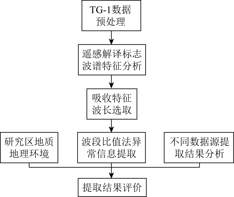
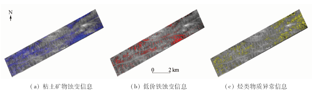
Abstract  

The hydrocarbon microseepage detection method with remote sensing technology is a direct way for oil and gas investigation. According to several anomalous phenomena above oil and gas reservoirs, such as the enrichment of low-grade iron elements, the abundance of clay minerals and high carbonate content, this paper proposes an oil and gas alteration information extraction theory with hyperspectral method. Based on the theory, the authors analyzed the spectral response characteristics of various hydrocarbon alteration materials with hyperspectral data of the Tiangong-1(TG-1), highlighted targeted mineral feature information and at the same time suppressed the information of other ground objects, selected the high-absorption and high-reflection bands of the different interpretation signs, and then used the band ratio method to highlight and extract feature information. With the TG-1 hyperspectral data of Qingyang City, Gansu Province, the authors conducted oil and gas micro-seepage extraction and the results show that the distribution of the abnormal information of surface alteration is not only in good consistency with the local geological analysis results but also in good agreement with the actual oil and gas area data, thus verifying the feasibility of the method proposed in this paper and demonstrates the detection potential of TG-1 hyperspectral data.

Keywords hyper-spectrum      hydrocarbon micro-seepage      band ratio      alteration anomaly      TG-1     
:  TP79  
Corresponding Authors: Jie CHEN     E-mail: 187369859@qq.com;6592296@qq.com
Issue Date: 30 May 2018
Service
E-mail this article
E-mail Alert
RSS
Articles by authors
Dachang YANG
Jie CHEN
Zihong GAO
Yachao HAN
Cite this article:   
Dachang YANG,Jie CHEN,Zihong GAO, et al. Extraction of hydrocarbon micro-seepage information based on TG-1 hyperspectral data[J]. Remote Sensing for Land & Resources, 2018, 30(2): 107-113.
URL:  
https://www.gtzyyg.com/EN/10.6046/gtzyyg.2018.02.15     OR     https://www.gtzyyg.com/EN/Y2018/V30/I2/107
Fig.1  Hyper-spectral information extraction procedure of oil and gas micro-seepage
载荷 主要应用技术指标
谱段 光谱范围/nm 有效波段数/个 空间分辨率/m 光谱分辨率/nm 幅宽/km
TG-1高光谱成像仪 全色 500~800 1 5 20
可见光—近红外 400~1 000 64 10 10 10
短波红外 1 000~2 500 64 20 23 10
热红外 1 10 15
EO-1 Hyperion 可见光—近红外 356~1 058 70 30 10 7.5
短波红外 852~2 577 172 30 10 7.5
Proba CHRIS 模式1 406~1 003 62 34 6~20 13
模式2 406~1 036 18 17 6~33 13
模式3 438~1 035 18 17 6~33 13
模式4 486~796 18 17 6~11 13
模式5 438~1 036 34 17 6~33 13
Tab.1  Comparison of TG-1 hyperspectral imaging system and the other space sensors
Fig.2  Continuum removed spectral curves of typical clay minerals
矿物名称 英文 吸收位置 反射位置1 反射位置2 反射位置3 反射位置4
高岭石 Kaolinite 2 205 753.5~1 273.5 1 503.5~2 025 2 225~2 265
蒙脱石 Montmorillonite 2 215和1 915 753.5~1 323.5 1 546.0~1 835 2 055~2 175 2 255~2 295
白云母 Muscovite 2 205 750.5~1 368.5 1 503.5~2 135 2 255~2 295
Tab.2  Statistic of typical clay mineral’s standard spectral features(nm)
Fig.3  Standard band curve comparison among minerals with three different iron ions
矿物名称 英文 吸收位置 反射位置1 反射位置2 反射位置3
Fe3+矿物 赤铁矿 Hematite 835.0~904.0 710.0~769.0 1 218.5~2 355.0
针铁矿 Goethite 883.0~976.0 728.0~806.5 1 288.5~1 612.5
黄钾铁矾 Jarosite 871.0~964.0 676.2~740.0 1 323.5~1 418.5 1 570.5~1 815.0
菱铁矿(Fe2+矿物) Siderite 1 000.0~1 288.5 746.0~835.0 1 684.0~1 875.0 2 045.0~2 205.0
褐铁矿(混合矿物) Limonite 957.0 740.0~785.0 1 368.5~1 885.0 2 115.0~2 155.0
Tab.3  Statistics of spectral features of different iron ions(nm)
Fig.4  Hydrocarbons spectrum
Fig.5  Extraction thematic maps of oil and gas micro-seepage
Fig.6  Comprehensive information extraction thematic map of oil and gas micro-seepage in Qingyang area
[1] Segal D B, Merin I S . Successful use of Landsat thematic mapper data for mapping hydrocarbon microseepage-induced mineralogic alteration, Lisbon Valley,Utah[J]. Photogrammetric Engineering and Remote Sensing, 1989,55(7):1137-1145.
url: http://www.researchgate.net/publication/282969441_Successful_use_of_Landsat_Thematic_Mapper_data_for_mapping_hydrocarbon_microseepage-induced_mineralogic_alteration_Lisbon_Valley_Utah
[2] Ellis J M, Davis H H, Zamudio A . Exploring for onshore oil seeps with hyperspectral imaging[J]. Oil and Gas Journal, 2001,99(37):49-58.
url: http://citeseerx.ist.psu.edu/viewdoc/summary?doi=10.1.1.121.8033
[3] 周密 . 油气微渗漏的高光谱信息提取研究[D].北京:中国地质大学(北京), 2007.
[3] Zhou M . Study on the Hyperspectral Information Extraction of Oil and Gas Microseepage[D].Beijing:China University of Geosciences (Beijing), 2007.
[4] 李娜, 周萍 . 基于ASTER数据和反射光谱分析的烃类微渗漏信息提取[J]. 地质力学学报, 2015,21(2):218-227.
url: http://www.cqvip.com/QK/98414X/201502/665571232.html
[4] Li N, Zhou P . Hydrocarbon microleakage information extraction based on ASTER data and reflectance spectroscopy[J]. Journal of Geomechanics, 2015,21(2):218-227.
[5] 陈圣波, 赵靓, 王晋年 . 黄土覆盖区油气微渗漏地表蚀变高光谱特征响应机理研究[J]. 光谱学与光谱分析, 2012,32(6):1616-1619.
url: http://www.opticsjournal.net/Articles/Abstract?aid=OJ120614000124EaHdKg
[5] Chen S B, Zhao L, Wang J N . Study on hyperspectral response to surface alteration by oil and gas microseepage under loess area[J]. Spectroscopy and Spectral Analysis, 2012,32(6):1616-1619.
[6] Kühn F, Oppermann K, Hörig B . Hydrocarbon index:An algorithm for hyperspectral detection of hydrocarbons[J]. International Journal of Remote Sensing, 2004,25(12):2467-2473.
doi: 10.1080/01431160310001642287 url: http://www.tandfonline.com/doi/abs/10.1080/01431160310001642287
[7] 王建民, 王佳媛 . 鄂尔多斯盆地伊陕斜坡上的低幅度构造与油气富集[J]. 石油勘探与开发, 2013,40(1):49-57.
url: http://www.cqvip.com/QK/90664X/201301/44578521.html
[7] Wang J M, Wang J Y . Low-amplitude structures and oil-gas enrichment on the Yishaan Slope, Ordos Basin[J]. Petroleum Exploration and Development, 2013,40(1):49-57.
[8] 李振华, 陈占军, 余岚 , 等. 庆阳地区上古生界天然气资源潜力评估[J]. 地下水, 2015,37(6):245-247.
url: http://d.wanfangdata.com.cn/Periodical/dixs201506101
[8] Li Z H, Chen Z J, Yu L , et al. Study on the potential of forming reservoir in Upper Paleozoic layer,Qing-yang area[J]. Ground Water, 2015,37(6):245-247.
[9] 杨华, 付金华, 刘新社 , 等. 鄂尔多斯盆地上古生界致密气成藏条件与勘探开发[J]. 石油勘探与开发, 2012,39(3):295-303.
url: http://www.cqvip.com/QK/90664X/201203/41909808.html
[9] Yang H, Fu J H, Liu X S , et al. Accumulation conditions and exploration and development of tight gas in the Upper Paleozoic of the Ordos Basin[J]. Petroleum Exploration and Development, 2012,39(3):295-303.
[10] 张天宇 . 基于高光谱遥感的黄土覆盖区油气微渗漏信息提取[D]. 长春:吉林大学, 2015.
[10] Zhang T Y . Extraction of Micro-Seepage of Oil and Gas Information in Loess Covered Area Based on Hyperspectral Remote Sensing[D]. Changchun:Jilin University, 2015.
[11] 易欢, 李健强, 韩海辉 , 等. 遥感技术在阿尔金贝壳滩地区矿产资源综合调查中的应用[J]. 中国地质调查, 2016,3(4):1-5.
url: http://www.cqvip.com/QK/72008X/201604/669751693.html
[11] Yi H, Li J Q, Han H H , et al. Application of remote sensing in integrated survey on mineral exploration in Beketan,Altyn[J]. Geological Survey of China, 2016,3(4):1-5.
[12] 闫柏琨, 董新丰, 王喆 , 等. 航空高光谱遥感矿物信息提取技术及其应用进展——以中国西部成矿带调查为例[J]. 中国地质调查, 2016,3(4):55-62.
[12] Yan B K, Dong X F, Wang Z , et al. Mineral information extraction technology by airborne hyperspectral remote sensing and its application progress:An example of mineralization belts of western China[J]. Geological Survey of China, 2016,3(4):55-62.
[1] WEI Yingjuan, LIU Huan. Remote sensing-based mineralized alteration information extraction and prospecting prediction of the Beiya gold deposit, Yunnan Province[J]. Remote Sensing for Natural Resources, 2021, 33(3): 156-163.
[2] Haihui HAN, Guangli REN, Yilin WANG, Min YANG, Anqiang YAO, Zhuan ZHANG. Application of collaborative processing method to the analysis of remote sensing alteration abnormal causes: A case study of Fangshankou area in Beishan[J]. Remote Sensing for Land & Resources, 2020, 32(1): 138-147.
[3] Honglin MA, Weijie JIA, Changliang FU, Wei LI. Extraction of geological structural and alteration information and the prediction of metallogenic favorable locations in northeastern Jeddah, Saudi Arabia[J]. Remote Sensing for Land & Resources, 2019, 31(3): 174-182.
[4] HAN Haihui, WANG Yilin, YANG Min, REN Guangli, YANG Junlu, LI Jianqiang, GAO Ting. Application of fractal dimension-change point method to the extraction of remote sensing alteration anomaly[J]. REMOTE SENSING FOR LAND & RESOURCES, 2017, 29(3): 137-142.
[5] DONG Lina, ZHANG Wei, WANG Xue, CHEN Ling, YANG Jinzhong, MO Zifen. Remote sensing geological interpretation and uranium prospecting perspective analysis of Shengyuan volcanic basin in Jiangxi Province[J]. REMOTE SENSING FOR LAND & RESOURCES, 2015, 27(4): 102-108.
[6] HU Fang, LIN Qi-zhong, WANG Qin-jun, WANG Ya-jun. Quantitative Inversion of Soil Potassium Content by Using Hyperspectral Reflectance[J]. REMOTE SENSING FOR LAND & RESOURCES, 2012, 24(4): 157-162.
[7] LIU Wen-lan, ZHANG Wei. Remote Sensing Structural Alteration Information Extraction and Ore Prognosis: A Case Study of Laos[J]. REMOTE SENSING FOR LAND & RESOURCES, 2012, 24(2): 68-74.
[8] WANG Feng-de, ZHAO Zhi-fang, MAO Yu-jing, TAN Shu-cheng. A Comprehensive Analysis of Remote Sensing Geological Characteristics and Ore Prospecting Perspective of Luchun Area,Yunnan Province[J]. REMOTE SENSING FOR LAND & RESOURCES, 2012, 24(2): 98-104.
[9] DIAO Hai, ZHANG Da, DI Yong-Jun, WANG Zhen, WANG Hao-Ran, XIONG Guang-Qiang.
The Extraction of Alteration Anomalies from ASTER Data Based on Principal Component Analysis and Fractal Model
[J]. REMOTE SENSING FOR LAND & RESOURCES, 2011, 23(2): 75-80.
[10] SHEN Jin-Li, DING Shu-Bai, QI Xiao-Ping, XiNG Hua-Wen. The Progress of Remote Sensing Technology in the Detection of Hydrocarbon Micro-seepage[J]. REMOTE SENSING FOR LAND & RESOURCES, 2010, 22(3): 7-11.
[11] YANG Jin-zhong, FANG Hong-bin, ZHANG Yu-jun, CHEN Wei. REMOTE SENSING ANOMALY EXTRACTION IN IMPORTANT METALLOGENIC BELTS OF WESTERN CHINA[J]. REMOTE SENSING FOR LAND & RESOURCES, 2003, 15(3): 50-53.
[12] ZHANG Yu-jun, YANG Jian-min, CHEN Wei. A STUDY OF THE METHOD FOR EXTRACTIOH OF ALTERATION ANOMALIES FROM THE ETM~+(TM) DATA AND ITS APPLICATION: Geologic Basis and Spectral Precondition[J]. REMOTE SENSING FOR LAND & RESOURCES, 2002, 14(4): 30-36.
[13] Dong Wenming, Huang Xianfang, Xie Zhidong, Huang Shutiao, Pan Wei . THE APPLICATION OF TM AND SAR AS WELL AS AIRBORNE RADIOACTIVE DATA TO PROSPECT FOR URANIUM DEPOSIT OF SANDSTONE TYPE[J]. REMOTE SENSING FOR LAND & RESOURCES, 1997, 9(4): 21-25.
Viewed
Full text


Abstract

Cited

  Shared   
  Discussed   
京ICP备05055290号-2
Copyright © 2017 Remote Sensing for Natural Resources
Support by Beijing Magtech