|
|
 |
|

|
|
|
Remote sensing monitoring of salinization in Hetao irrigation district based on SI-MSAVI feature space |
Jing LU1,3, Xujiao ZHANG1( ), Peisheng YE2, Hang WU1, Tao WANG1 ), Peisheng YE2, Hang WU1, Tao WANG1 |
1. School of Earth Sciences and Resources, China University of Geosciences(Beijing), Beijing 100083, China
2. Institute of Geomechanics, Chinese Academy of Geological Sciences, Beijing 100081, China
3. Beijing Institute of Exploration Engineering, China Geological Survey, Beijing 100083, China |
|
|
|
|
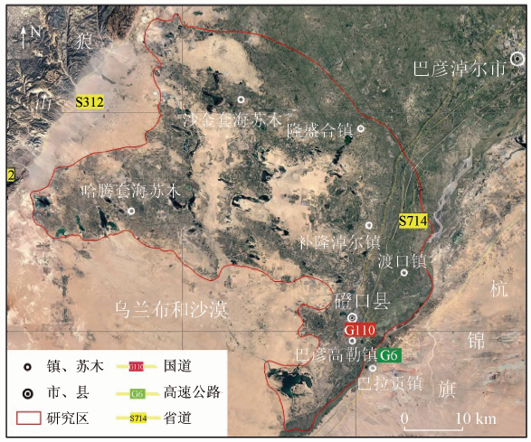
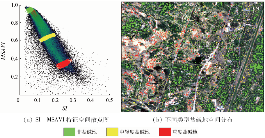
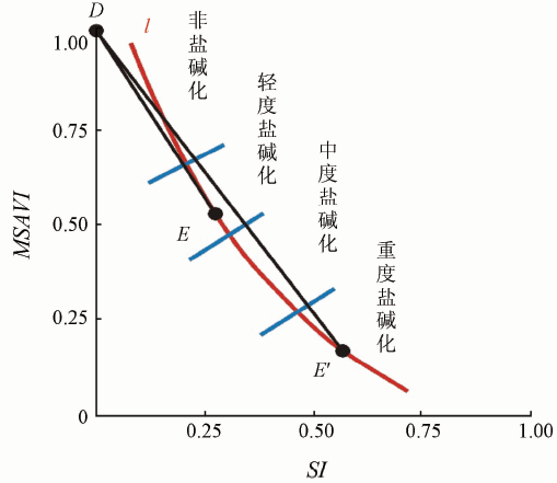
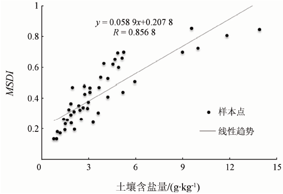
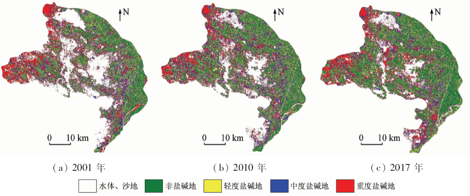
Abstract The soil salinization in Hetao irrigation district of Inner Mongolia has exerted severe impact on the sustainable development of local agriculture and economy. Remote sensing can be applied to achieve the real-time information of soil salinization so as to monitor salinization’s future changes. The authors used the satellite images of Landsat to extract salt index (SI) and modified soil mediation vegetation index (MSAVI) and then combined them to construct modified salinization detection index (MSDI) model so as to quantitatively analyze and monitor the soil salinization in this research. After that, the soil salinization information in the study areas obtained in 2001, 2010 and 2017 was further classified and statistically analyzed, which showed an obvious diversity of MSDI mean among various alkali soil types. The result of MSDI was validated by the precision test, field investigation and the salinity of soil samples. The validation demonstrated a strong correlation of 0.856 8 between MSDI and soil salinity, a precision test accuracy of 87.5%, and a Kappa index of 0.726. The soil salinization of this area had been mitigated according to portion changes of non-alkali soil area (from 18.5% to 30.47%) and the fragmented tendency of moderately saline land since 2001. The result indicates that MSDI based on the SI-MSAVI feature space could be applied to quantitatively extract the information of soil salinization and proves to be efficient in monitoring the development of salinization in this region.
|
| Keywords
SI-MSAVI feature space
image of Landsat
Hetao irrigation district
salinization
MSDI
|
|
|
|
Corresponding Authors:
Xujiao ZHANG
E-mail: zhangxj@cugb.edu.cn
|
|
Issue Date: 14 March 2020
|
|
|
| [1] |
Wang Y G, Li Y, Xiao D N . Catchment scale spatial variability of soil salt content in agricultural oasis,Northwest China[J]. Environmental Geology, 2008,56(2):439-446.
|
| [2] |
Wang J Z, Wu J L, Jia J H . Analysis of spatial variation of soil salinization using a hydro chemical and stable isotopic method in a semiarid irrigated basin,Hetao Plain,Inner Mongolia,North China[J]. Environmental Processes, 2016,3(4):723-733.
|
| [3] |
Yu R H, Liu T X, Xu Y P , et al. Analysis of salinization dynamics by remote sensing in Hetao irrigation district of North China[J]. Agricultural Water Management, 2010,97(12):1952-1960.
|
| [4] |
程宇翔 . 土壤盐分遥感监测研究进展[J]. 现代农业科技, 2016(19):185-194.
|
| [4] |
Cheng Y X . Research progress of soil salinity monitoring by remote sensing[J]. Modern Agricultural Science and Technology, 2016(19):185-194.
|
| [5] |
Mashimbye Z E, Cho M A, Nell J P , et al. Model-based integrated methods for quantitative estimation of soil salinity from hyper spectral remote sensing data:A case study of selected South African soils[J]. Pedosphere, 2012,22(5):640-649.
|
| [6] |
Judkins G, Myint S . Spatial variation of soil salinity in the Mexicali Valley,Mexico:Application of a practical method for agricultural monitoring[J]. Environmental Management, 2012,50(3):478-489.
|
| [7] |
Wang J Z, Wu J L, Zeng H A . Sediment record of abrupt environmental changes in Lake Chenpu,upper reaches of Yellow River Basin,north China[J]. Environmental Earth Sciences, 2015,73(10):6355-6363.
|
| [8] |
郭娇, 王伟, 叶浩 , 等. 河套平原盐渍化土地时空动态变化及影响因子[J]. 南水北调与水利科技, 2014,12(3):59-64.
|
| [8] |
Guo J, Wang W, Ye H , et al. Analysis on spatial and temporal dynamic variations and their impact factors of salinization land in Hetao Plain[J]. South-to-North Water Transfers and Water Science and Technology, 2014,12(3):59-64.
|
| [9] |
郭姝姝, 阮本清, 管孝艳 , 等. 内蒙古河套灌区近30年盐碱化时空演变及驱动因素分析[J]. 中国农村水利水电, 2016(9):159-162,167.
|
| [9] |
Guo S S, Ruan B Q, Guan X Y , et al. Analysis on spatial-temporal evolution of soil salinity and its driving factors in Hetao irrigation district during recent 30 years[J]. China Rural Water and Hydropower, 2016(9):159-162,167.
|
| [10] |
丁建丽, 姚远, 王飞 . 干旱区土壤盐渍化特征空间建模[J]. 生态学报, 2014,36(16):4620-4631.
|
| [10] |
Ding J L, Yao Y, Wang F . Detecting soil salinization in arid regions using spectral feature space derived from remote sensing data[J]. Acta Ecologica Sinica, 2014,36(16):4620-4631.
|
| [11] |
王飞, 丁建丽, 伍漫春 . 基于NDVI-SI特征空间的土壤盐渍化遥感模型[J]. 农业工程学报. 2010,26(8):168-173.
|
| [11] |
Wang F, Ding J L, Wu M C . Remote sensing monitoring models of soil salinization based on NDVI-SI feature space[J]. Transactions of the Chinese Society of Agricultural Engineering, 2010,26(8):168-173.
|
| [12] |
哈学萍, 丁建丽 , 等. 基于SI-Albedo特征空间的土壤盐渍化遥感监测指数研究[J]. 土壤学报, 2009,46(4):698-703.
|
| [12] |
Ha X P, Ding J L , et al. SI-Albedo space-based extraction of salinization information in arid area[J]. Acta Pedolagica Sinica, 2009,46(4):698-703.
|
| [13] |
丁建丽, 瞿娟, 孙永猛 , 等. 基于MSAVI-WI特征空间的新疆渭干河—库车河流域绿洲土壤盐渍化研究[J]. 地理研究, 2013,32(2):223-232.
|
| [13] |
Ding J L, Qu J, Sun Y M , et al. The retrieval model of soil salinization information in arid region based on MSAVI-WI feature space:A case study of the delta oasis in Weigan—Kuqa watershed[J]. Geographical Research, 2013,32(2):223-232.
|
| [14] |
Deering D W . Rangeland Reflectance Characteristics Measured by Aircraft and Spacecraft Sensors[D]. College Station:Texas A&M University, 1978.
|
| [15] |
姜海兰 . 利用多时相Landsat卫星影像直接提取沙漠化区域的简便方法[D]. 兰州:兰州大学, 2014.
|
| [15] |
Jiang H L . A Simple Method of Directly Extracting Sandy Desertification Area Based on Multi-Temporal Landsat Satellite Images[D]. Lanzhou:Lanzhou University, 2014.
|
| [16] |
Hardisky M A, Klemas V, Smart R M . The influence of soil salinity,growth form,and leaf moisture on the spectral radiance of Spartina alterniflora canopies[J]. Photogrammetric Engineering and Remote Sensing, 1983,49(1):77-84.
|
| [17] |
张添佑, 王玲, 曾攀丽 , 等. 基于MSAVI-SI特征空间的玛纳斯河流流域灌区土壤盐渍化研究[J]. 干旱区研究, 2016,33(3):499-505.
|
| [17] |
Zhang T Y, Wang L, Zeng P L , et al. Soil salinization in the irrigated area of the Manas River basin based on MSAVI-SI feature space[J]. Arid Zone Research, 2016,33(3):499-505.
|
| [18] |
冯娟, 丁建丽, 魏雯瑜 . 基于Albedo-MSAVI特征空间的渭库绿洲土壤盐渍化研究[J]. 中国农村水利水电, 2018(2):147-152.
|
| [18] |
Feng J, Ding J L, Wei W Y . A study of soil salinization in Weigan and Kuqa Rivers oasis based on Albedo-MSAVI feature space[J]. China Rural Water and Hydropower, 2018(2):147-152.
|
| [19] |
Allbed A, Kumar L, Aldakheel Y Y . Assessing soil salinity using soil salinity and vegetation indices derived from IKONOS high-spatial resolution imageries:Applications in a date palm dominated region[J]. Geoderma, 2014(230):1-8.
|
| [20] |
Qi J, Chehbouni A, Huete A R , et al. A modified soil adjusted vegetation index[J]. Remote Sensing of Environment, 1994,48(2):119-126.
|
| [21] |
Khan N M, Sato Y . Monitoring hydro-salinity status and its impact in irrigated semi-arid areas using IRS-1B LISS-II data[J]. Asian Journal of Geoinform, 2001,1(3):63-73.
|
| [22] |
Liang S . Narrowband to broadband coaversions of land surface albedo:Algorighms[J]. Remote Sensing of Environment, 2001,76(2):213-238.
|
| [23] |
Verstraete M, Pinty B . Designing optimal spectral indexes for remote sensing applications[J]. IEEE Transactions on Geoscience and Remote Sensing, 1996,34(5):1254-1265.
|
|
Viewed |
|
|
|
Full text
|
|
|
|
|
Abstract
|
|
|
|
|
Cited |
|
|
|
|
| |
Shared |
|
|
|
|
| |
Discussed |
|
|
|
|
 2020,
Vol. 32
2020,
Vol. 32