|
|
 |
|

|
|
|
Validation of LAI retrieval results of winter wheat in Yancheng, Luohe area of Henan Province |
Hui YUAN1,4, Qiming QIN1,2,3( ), Yuanheng SUN1 ), Yuanheng SUN1 |
1. Institute of Remote Sensing and Geographical Information System, School of Earth and Space Sciences, Peking University, Beijing 100871, China
2. Beijing Key Lab of Spatial Information Integration and Its Application, Peking University, Beijing 100871, China
3. Geographic Information Engineering Technology Center of Geographic Information Basic Software and Application, Beijing 100871, China
4. 96944 Troops of PLA, Beijing 100096, China |
|
|
|
|
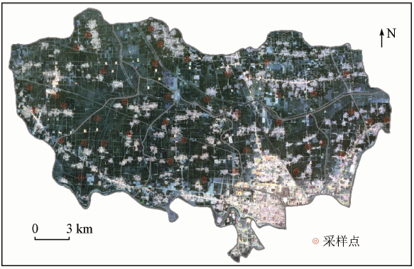
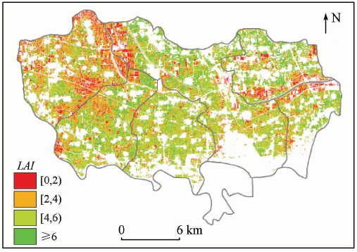
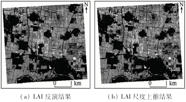
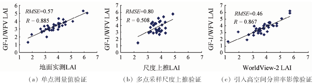
Abstract In order to compare the validation performances of different validation methods on the GF-1/WFV winter wheat LAI retrieval results, the authors chose Yancheng, Luohe City of Henan Province as the study area. Three methods, i.e., single point ground measurement validation, multi-point upscaling validation, and high-resolution result validation, were tested to verify the performance of winter wheat LAI inversion based on GF-1/WFV image. The results show that the RMSE obtained by the above three verification methods are 0.57,0.80 and 0.46,respectively. The correlation coefficients are 0.885, 0.508 and 0.867,respectively. The multi-point upscaling method has higher requirements for the number of sampling points and the position of sampling points. Therefore, the accuracy is low and the effect is poor in the case of fewer sampling points in this study. The other two methods have relatively high precision and applicability, and the validation method with the introduction of high-resolution image achieves higher precision, and hence this method is more suitable for the validation of LAI inversion of GF-1/WFV images.
|
| Keywords
LAI
GF-1/WFV
winter wheat
validation
|
|
|
|
Corresponding Authors:
Qiming QIN
E-mail: qmqinpku@163.com
|
|
Issue Date: 14 March 2020
|
|
|
| [1] |
Chen J M, Black T A . Defining leaf area index for non-flat leaves[J]. Plant Cell and Environment, 1992,15:421-429.
|
| [2] |
李淑敏, 李红, 孙丹峰 , 等. PROSAIL冠层光谱模型遥感反演区域叶面积指数[J]. 光谱学与光谱分析, 2009,29(10):2725-2729.
|
| [2] |
Li S M, Li H, Sun D F , et al. Estimation of regional leaf area index by remote sensing inversion of PROSAIL canopy spectral model[J]. Spectroscopy and Spectral Analysis, 2009,29(10):2725-2729.
|
| [3] |
Darvishzadeh R, Skidmore A, Schlerf M , et al. Inversion of a radiative transfer model for estimating vegetation LAI and chlorophyll in a heterogeneous grassland[J]. Remote Sensing of Environment, 2008,112(5):2592-2604.
|
| [4] |
Haboudane D . Hyperspectral vegetation indices and novel algorithms for predicting green LAI of crop canopies:Modeling and validation in the context of precision agriculture[J]. Remote Sensing of Environment, 2004,90(3):337-352.
|
| [5] |
Zhao D H, Yang T W, An S Q . Effects of crop residue cover resulting from tillage practices on LAI estimation of wheat canopies using remote sensing[J]. International Journal of Applied Earth Observation and Geoinformation, 2012,14(1):169-177.
|
| [6] |
Li X W, Strahler A H,and Woodcock C . A hybrid geometric optical-radiative transfer approach for modeling albedo and directional reflectance of discontinuous canopies[J]. IEEE Transaction on Geoscience and Remote Sensing, 1995,33(2):466-480.
|
| [7] |
李鑫川, 徐新刚, 鲍艳松 , 等. 基于分段方式选择敏感植被指数的冬小麦叶面积指数遥感反演[J]. 中国农业科学, 2012,45(17):3486-3496.
|
| [7] |
Li X C, Xu X G, Bao Y S , et al. Retrieving LAI of winter wheat based on sensitive vegetation index by the segmentation method[J]. Scientia Agricultura Sinica, 2012,45(17):3486.
|
| [8] |
Justice C, Belward A, Morisette J , et al. Developments in the “validation” of satellite sensor products for the study of the land surface[J]. International Journal of Remote Sensing, 2000,21(17):2283-3390.
|
| [9] |
吴小丹, 闻建光, 肖青 , 等. 关键陆表参数遥感产品真实性检验方法研究进展[J]. 遥感学报, 2015,19(1):76-92.
|
| [9] |
Wu X D, Wen J G, Xiao Q , et al. Advances invalidation methods for remote sensing products of land surface parameters[J]. Journal of Remote Sensing, 2015,19(1):76-92.
|
| [10] |
Fensholt R, Sandholt I, Rasmussen M S . Evaluation of MODIS LAI,FAPAR and the relation between FAPAR and NDVI in a semiarid environment using in situ measurements[J]. Remote Sensing of Environment, 2004,91(3-4):490-507.
|
| [11] |
Privette J L, Myneni R B, Knyazikhin Y , et al. Early spatial and temporal validation of MODIS LAI product in the Southern Africa Kalahari[J]. Remote Sensing of Environment, 2002,83(1/2):232-243.
|
| [12] |
家淑珍, 马明国, 于文凭 . 黑河中游LAI产品真实性检验研究[J]. 遥感技术与应用, 2014,29(6), 1037-1045.
|
| [12] |
Jia S Z, Ma M G, Yu W P . Validation of LAI product in Heihe river basin[J]. Remote Sensing Technology and Application, 2014,29(6):1037-1045.
|
| [13] |
Liang S L, Fang H L, Chen M Z , et al. Validating MODIS land surface reflectance and albedo products:Methods and preliminary results[J]. Remote Sensing of Environment, 2002,83(1-2):149-162.
|
| [14] |
张仁华, 田静, 李召良 , 等. 定量遥感产品真实性检验的基础与方法[J]. 中国科学(地球科学), 2010,40(2):211-222.
|
| [14] |
Zhang R H, Tian J, Li Z L , et al. Principles and methods for the validation of quantitative remote sensing products[J]. Science in China (Earth Science), 2010,40(2):211-222.
|
| [15] |
Qu Y H, Zhu Y Q, Han W C , et al. Crop leaf area index observations with a wireless sensor network and its potential for validating remote sensing products[J]. IEEE Journal of Selected Topics in Applied Earth Observations and Remote Sensing, 2014,7(2):431-444.
|
| [16] |
Weiss M, Baret F, Garrigues S , et al. LAI and FAPAR CYCLOPES global products derived from Vegetation.Part 2:Validation and comparison with MODIS collection 4 products[J]. Remote Sensing of Environment, 2007,110(3):317-331.
|
| [17] |
Garrigues S, Lacaze R, Baret F , et al. Validation and intercomparison of global leaf area index products derived from remote sensing data[J]. Journal of Geophysical Research:Biogeosciences, 2008,113:G2.
|
| [18] |
Jin H A, Li A N, Bian J H , et al. Intercomparison and validation of MODIS and GLASS leaf area index (LAI) products over mountain areas:A case study in southwestern China[J]. International Journal of Applied Earth Observation and Geoinformation, 2017,55(2017):52-67.
|
| [19] |
Li H, Liu G, Liu Q , et al. Retrieval of winter wheat leaf area index from Chinese GF-1 satellite data using the PROSAIL model[J]. Sensors, 2018,18(4):1120-1138.
|
| [20] |
Bicheron P, Leroy M . A method of biophysical parameter retrieval at global scale by inversion of a vegetation reflectance model[J]. Remote Sensing of Environment, 1999,67(3):P251-266.
|
| [21] |
刘洋, 刘荣高, 陈镜明 , 等. 叶面积指数遥感反演研究进展与展望[J]. 地球信息科学学报, 2013,15(5):734-743.
|
| [21] |
Liu Y, Liu R G, Chen J M , et al. Current status and perspectives of leaf area index retrieval from optical remote sensing data[J]. Journal of Geo-Information Science, 2013,15(5):734-743.
|
| [22] |
Sun Y H, Ren H Z, Zhang T Y , et al. Crop leaf area index retrieval based on inverted difference vegetation Index and NDVI[J]. IEEE Geoscience and Remote Sensing Letters, 2018,15(11):1662-1666.
|
|
Viewed |
|
|
|
Full text
|
|
|
|
|
Abstract
|
|
|
|
|
Cited |
|
|
|
|
| |
Shared |
|
|
|
|
| |
Discussed |
|
|
|
|
 2020,
Vol. 32
2020,
Vol. 32