|
|
 |
|
|
|
|
The application of UAV oblique photography in debris flow disaster identification and analysis:Taking the debris flow in Caojiafang, Shijiaying, Fangshan District, Beijing as an Example |
YAN Chi( ), JIAO Runcheng, CAO Ying, NAN Yun, WANG Shengyu, GUO Xuefei ), JIAO Runcheng, CAO Ying, NAN Yun, WANG Shengyu, GUO Xuefei |
| Beijing Institute of Geology, Beijing 100120, China |
|
|
|
|
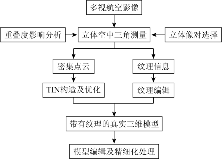
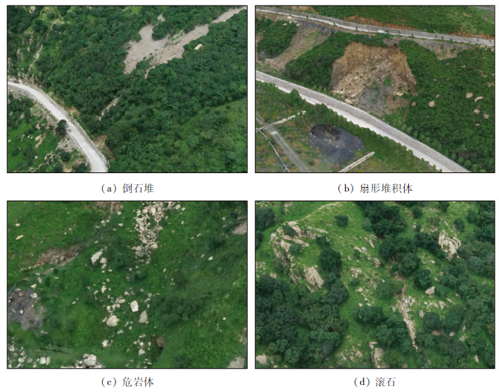
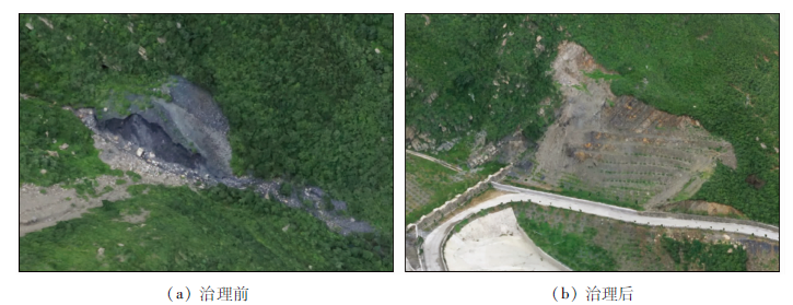
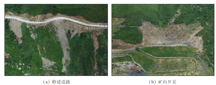
Abstract The traditional remote sensing survey method of debris flow is mainly orthophoto aerial photography, which has limitations in the accuracy and dimension of data acquisition. UAV tilt photography technology can simultaneously acquire images from different angles, such as vertical and tilt, obtain more complete and accurate information of ground objects, establish more intuitive three-dimensional model, and provide new technical means for geological disaster investigation. Taking the Caojiafang debris flow gully in Shijiaying as an example, the authors carried out the feature recognition analysis of debris flow disaster based on UAV tilt photogrammetry. It is believed that the high-precision three-dimensional model and texture details of debris flow gully can be obtained by incline photography, which can truly reflect the high-resolution information of the top and side of the real surface, and accurately obtain the distribution of debris flow material source and the estimation of material source volume; the data can be used to calculate the maximum amount of debris flow once washed out. This method can provide a more powerful means for the investigation of debris flow geological disasters and the assessment of current situation. The remote sensing technology can be fully used in the investigation and evaluation of debris flow disaster.
|
| Keywords
oblique photography
debris flow
three-dimensional model
remote sensing identification and analysis
|
|
|
|
Issue Date: 23 December 2020
|
|
|
| [1] |
郑史芳, 黎治坤. 结合倾斜摄影技术的地质灾害监测[J]. 测绘通报, 2018(8):88-92.
|
| [1] |
Zheng S F, Li Z K. Geological hazard monitoring combined with tilt photography[J]. Surveying and Mapping Bulletin, 2018(8):88-92.
|
| [2] |
李杨. 无人机倾斜摄影技术在地质灾害调查监测中的应用[J]. 冶金与材料, 2018,36(3):18-24.
|
| [2] |
Li Y. Application of UAV tilt photography technology in geological hazard investigation and monitoring[J]. Metallurgy and Materials, 2018,36(3):18-24.
|
| [3] |
刘对萍, 潘艳宾. 无人机倾斜摄影在泥石流灾害调查中的应用[J]. 土地开发工程研究, 2016(6):34-39.
|
| [3] |
Liu D P, Pan Y B. Application of UAV tilt photography in debris flow disaster investigation[J]. Land Development Engineering Research, 2016(6):34-39.
|
| [4] |
杨娟, 无人机倾斜摄影在地质灾害三维可视化中的应用[J]. 中国锰业, 2017,35(2):38-43.
|
| [4] |
Yang J. The application of UAV tilt photography in three-dimensional visualization of geological hazards[J]. China Manganese Industry, 2017,35(2):38-43.
|
| [5] |
魏永明, 郭华东, 陈玉, 等. 甘肃省舟曲特大泥石流的遥感影像特征及古泥石流遥感识别的地质意义[J]. 第四纪研究, 2014,34(2):28-33.
|
| [5] |
Wei Y M, Guo H D, Chen Y, et al. Remote sensing image characteristics of Zhouqu super-large debris flow in Gansu Province and geological significance of remote sensing identification of ancient debris flow[J]. Quaternary Study, 2014,34(2):28-33.
|
| [6] |
王润生, 熊盛青, 聂洪峰, 等. 遥感地质勘查技术与应用[J]. 地质学报, 2011,85(11):1699-1743.
url: http://www.geojournals.cn/dzxb/ch/reader/view_abstract.aspx?file_no=2011364&flag=1
|
| [6] |
Wang R S, Xiong S Q, Nie H F, et al. Remote sensing technology and its application in geological exploration[J]. Acta Geologica Sinica, 2011,85(11):1699-1743.
|
| [7] |
童立强, 聂洪峰, 李建存, 等. 喜马拉雅山地区大型泥石流遥感调查与发育特征研究[J]. 国土资源遥感, 2013,25(4):104-112.doi: 10.6046/gtzyyg.2013.04.17.
doi: 10.6046/gtzyyg.2013.04.17
url: http://www.gtzyyg.com/CN/abstract/abstract1685.shtml
|
| [7] |
Tong L Q, Nie H F, Li J C, et al. Survey of large-scale debris flow and study of its development characteristics using remote sensing technology in the Himalayas[J]. Remote Sensing for Land and Resources, 2013,25(4):104-112.doi: 10.6046/gtzyyg.2013.04.17.
|
| [8] |
郭兆成, 童立强, 郑雄伟, 等. 四川庐山地震次生地质灾害遥感调查及灾害特征初探[J]. 国土资源遥感, 2014,26(3):99-105.doi: 10.6046/gtzyyg.2014.03.16.
doi: 10.6046/gtzyyg.2014.03.16
url: http://www.gtzyyg.com/CN/abstract/abstract1775.shtml
|
| [8] |
Guo Z C, Tong L Q, Zheng X W, et al. Remote sensing survey of secondary geological disasters triggered by Lushan earthquake in Sichuan Province and tentative discussion on disaster characteristics[J]. Remote Sensing for Land and Resources, 2014,26(3):99-105.doi: 10.6046/gtzyyg.2014.03.16.
|
| [9] |
张志军, 庄永成. 基于GF-1数据的地质灾害遥感调查——以青海省大通县为例[J]. 科学技术与工程, 2017,17(18):9-17.
|
| [9] |
Zhang Z J, Zhuang Y C. The survey of geological hazards based on GF-1 data:Taking example for Datong County,Qinghai Province[J]. Science Technology and Engineering, 2017,17(18):9-17.
|
| [10] |
王钦军, 陈玉, 蔺启忠, 等. 矿山地质灾害遥感监测方法及成因分析[J]. 中国地质灾害与防治学报, 2011,22(1):75-79.
|
| [10] |
Wang Q J, Chen Y, Lin Q Z, et al. Geological hazards monitoring method and its formation analysis in mining area[J]. The Chinese Journal of Geological Harzard and Control, 2011,22(1):75-79.
|
| [11] |
马思顺, 陈志雄, 王瑞雪, 等. 遥感技术在地质灾害调查中的应用[J]. 地质灾害与环境保护, 2017,28(4):80-86.
|
| [11] |
Ma S S, Chen Z X, Wang R X, et al. Application of remote sensing technology in geological hazard investigation[J]. Journal of Geological Hazards and Environment Preservation, 2017,28(4):80-86.
|
|
Viewed |
|
|
|
Full text
|
|
|
|
|
Abstract
|
|
|
|
|
Cited |
|
|
|
|
| |
Shared |
|
|
|
|
| |
Discussed |
|
|
|
|
 2020,
Vol. 32
2020,
Vol. 32