|
|
 |
|

|
|
|
Transportation in the Siliguri Corridor, West Bengal, India: distribution characteristics, trafficability, and geological environment |
SUN Ang1( ), YANG Qinghua1, LIU Zhi2(), CHEN Hua1, JIANG Xiao1, JIANG Shoumin2, BIAN Yu1, TIAN Li2 ), YANG Qinghua1, LIU Zhi2(), CHEN Hua1, JIANG Xiao1, JIANG Shoumin2, BIAN Yu1, TIAN Li2 |
1. China Aero Geophysical Survey and Remote Sensing Center for Natural Resources, Beijing 100083, China
2. Sichuan Geological Survey Institute, Chengdu 610036, China |
|
|
|
|
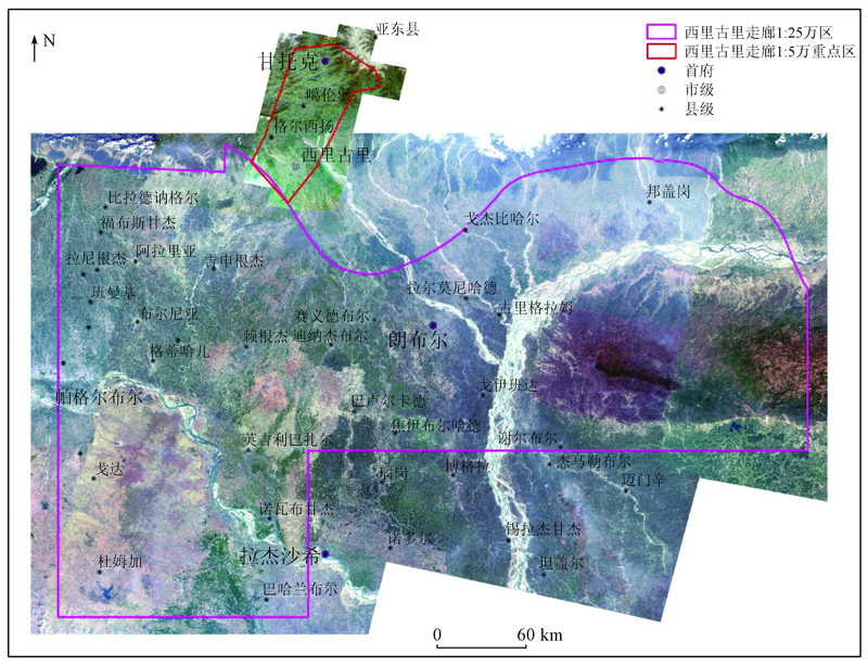
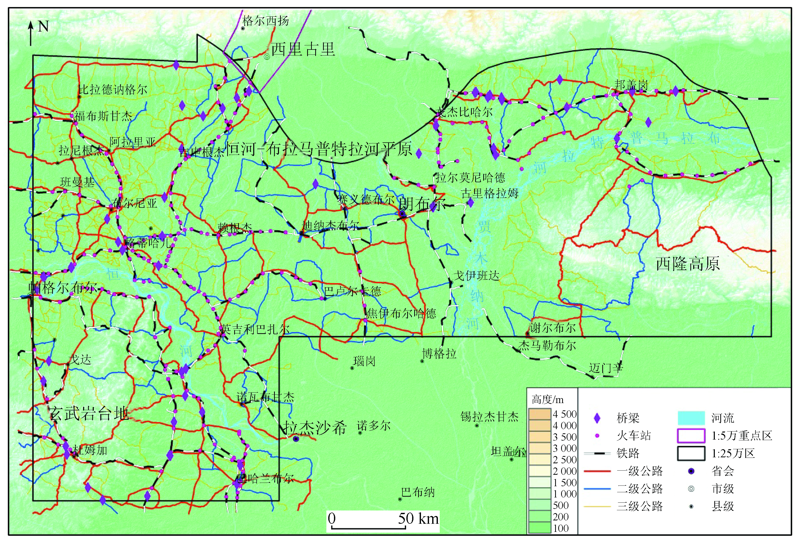
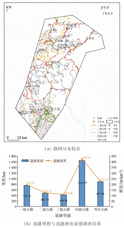
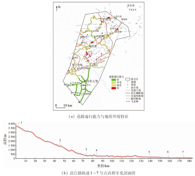
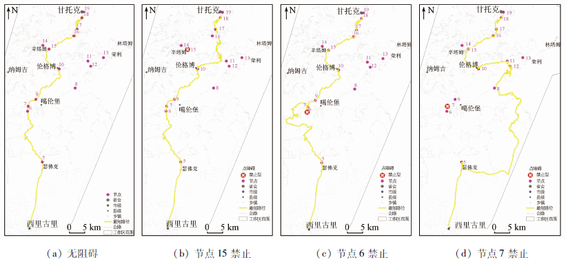
Abstract Remote sensing interpretation of the Siliguri Corridor, West Bengal, India was carried out based on 33 scenes of multispectral remote sensing images from GF-1 and GF-2 satellites, which cover an area of 154 814 km2. As a result, the mileage, density, and distribution of highways at all levels in the Siliguri Corridor were obtained, and the overall characteristics of the transportation in the area were ascertained. Then this paper assessed the trafficability in the selected key areas using the weighted scoring method from the aspects such as landform, lithology, geologic disasters, and road conditions. Furthermore, the factors such as the variation and relative decrease rate of whole network’s efficiency (ΔE and e) of 19 pivotal nodes were calculated using the complex network theory. They can be used to characterize the importance of pivotal nodes relative to the overall trafficability of the road network. For the four most important pivotal nodes, the geological environment characteristics (i.e., important targets, slope, and engineering rock and soil masses in the peripheries of the nodes) were analyzed and potential disasters and risks were proposed.
|
| Keywords
Siliguri Corridor
transportation
distribution characteristics
trafficability
geological environment
|
|
|
|
Corresponding Authors:
LIU Zhi
E-mail: sunangjlu@163.com;149275949@qq.com
|
|
Issue Date: 24 September 2021
|
|
|
| [1] |
Small K A, Verhoef E T. The economics of urban transportation[M]. London: Routledge, 2007.
|
| [2] |
Vuchic V R. Urban public transportation systems[D]. Philadelphia:University of Pennsylvania, 2002.
|
| [3] |
Button K. Transport economics[M]. London: Edward Elgar Publishing, 2010.
|
| [4] |
王润生, 童立强, 林键, 等. 遥感地质勘查技术与应用研究[J]. 地质学报, 2011, 85(11):1699-1743.
|
| [4] |
Wang R S, Tong L Q, Lin J, et al. Remote sensing technology and its application in geological exploration[J]. Acta Geologica Sinica, 2011, 85(11):1699-1743.
|
| [5] |
付长亮, 杨清华, 姜琦刚, 等. 遥感技术在境外地质调查中的应用——以津巴布韦大岩墙为例[J]. 国土资源遥感, 2015, 27(4):85-92.doi: 10.6046/gtzyyg.2015.04.14.
doi: 10.6046/gtzyyg.2015.04.14
|
| [5] |
Fu C L, Yang Q H, Jiang Q G, et al. Application of remote sensing technique to geological survey abroad:A case study of Great Dyke,Zimbabwe[J]. Remote Sensing for Land and Resources, 2015, 27(4):85-92.doi: 10.6046/gtzyyg.2015.04.14.
doi: 10.6046/gtzyyg.2015.04.14
|
| [6] |
于德浩, 龙凡, 杨清雷, 等. 现代军事遥感地质学发展及其展望[J]. 中国地质调查, 2017, 4(3):74-82.
|
| [6] |
Yu D H, Long F, Yang Q L, et al. Development and prospects of modern military remote sensing geology[J]. Geological Survey of China, 2017, 4(3):74-82.
|
| [7] |
张栋, 吕新彪, 葛良胜, 等. 军事地质环境的研究内涵与关键技术[J]. 地质论评, 2019, 65(1):181-198.
|
| [7] |
Zhang D, Lyu X B, Ge L S, et al. Research connotation and key technology of the military geological environment in the land battlefield[J]. Geological Review, 2019, 65(1):181-198.
|
| [8] |
徐泽鸿, 杨雪清, 李超, 等. 基于德国国家监测数据的境外遥感抽样调查方法研究[J]. 林业资源管理, 2014(1):41-51.
|
| [8] |
Xu Z H, Yang X Q, Li C, et al. Research on overseas RS sampling inventory approach based on German NFI data[J]. Forest Resources Management, 2014(1):41-51.
|
| [9] |
杨清华, 陈华, 孟月玥, 等. 全国边海防地区基础地质遥感调查[R]. 北京:中国自然资源航空物探遥感中心, 2018.
|
| [9] |
Yang Q H, Chen H, Meng Y Y, et al. Geological remote sensing of national border and costal defense areas[R]. Beijing:China Aero Geophysical Survey & Remote Sensing Center for Natural Resources, 2018.
|
| [10] |
杨清华, 于德浩, 龙凡, 等. 全国边海防地区遥感地质调查技术要求[S]. 北京: 地质出版社, 2018.
|
| [10] |
Yang Q H, Yu D H, Long F, et al. Skills requirement of geological remote sensing of national border and costal defense areas[S]. Beijing: Geological Publishing House, 2018.
|
| [11] |
郭瑞军. 基于间隙接受理论的环形交叉口通行能力研究[D]. 北京:北京交通大学, 2013.
|
| [11] |
Guo R J. Study on capacity of roundabouts based on gap acceptance theory[D]. Beijing:Beijing Jiaotong University, 2013.
|
| [12] |
陈金邕. 考虑可变通行能力及停车位约束的早高峰通勤问题研究[D]. 合肥:中国科学技术大学, 2019.
|
| [12] |
Chen J Y. Study on morning commute problem considering variable capacity and parking space constraint[D]. Hefei:University of Science and Technology of China, 2019.
|
| [13] |
吴鼎新. 间歇优先公交专用道的通行能力及其影响研究[D]. 南京:东南大学, 2019.
|
| [13] |
Wu D X. Study on capacity of bus lane with intermittent priority and its impacts[D]. Nanjing:Southeast University, 2019.
|
| [14] |
劭长桥, 张兴宇, 罗凯, 等. 高速公路施工区通行能力研究综述[J]. 武汉理工大学学报(交通科学与工程版), 2021, 45(2):207-212.
|
| [14] |
Shao C Q, Zhang X Y, Luo K, et al. A review of estimating capacity in expressway work zones[J]. Journal of Wuhan University of Technology, 2021, 45(2):207-212.
|
| [15] |
Latora V, Marchiori M. Is the Boston subway a small-world network?[J]. Physica A:Statistical Mechanics and Its Applications, 2002, 314(1-4):109-113.
doi: 10.1016/S0378-4371(02)01089-0
url: https://linkinghub.elsevier.com/retrieve/pii/S0378437102010890
|
| [16] |
Sen P, Dasgupta S, Chatterjee A, et al. Small-world properties of the Indian railway network[J]. Physical Review E, 2003, 67(3):036106.
doi: 10.1103/PhysRevE.67.036106
url: https://link.aps.org/doi/10.1103/PhysRevE.67.036106
|
| [17] |
Angeloudis P, Fisk D. Large subway systems as complex networks[J]. Physica A:Statistical Mechanics and Its Applications, 2006, 367:553-558.
doi: 10.1016/j.physa.2005.11.007
url: https://linkinghub.elsevier.com/retrieve/pii/S0378437105011994
|
| [18] |
金雷. 基于复杂网络的地域公路交通网抗毁性分析[D]. 长沙:国防科技大学, 2008.
|
| [18] |
Jin L. Survivability analysis of road traffic network in the area based on the complex network[D]. Changsha:National University of Defense Technology, 2008.
|
| [19] |
叶青. 基于复杂网络理论的轨道交通网络脆弱性分析[J]. 中国安全科学学报, 2012, 22(2):122-126.
|
| [19] |
Ye Q. Vulnerability analysis of rail transit based on complex network theory[J]. China Safety Science Journal, 2012, 22(2):122-126.
|
| [20] |
潘桂堂, 丁俊, 姚东生. 1:150万青藏高原及邻区地质图[Z]. 成都: 成都地图出版社, 2004.
|
| [20] |
Pan G T, Ding J, Yao D S. Geological map of the Qinghai-Tibet Plateau and adjacent areas (1:1,500,000)[Z]. Chengdu: Chengdu Map Publishing House, 2004.
|
| [21] |
Geological Purnia Quadrangle Map (1:250,000)[Z]. Geological Survey of India, 1995.
|
| [22] |
Geological Dumka Quadrangle Map (1:250,000)[Z]. Geological Survey of India, 1998.
|
| [23] |
Geological map of Eastern Nepal (1:250,000)[Z]. ADM Carto Consult Pvt. Ltd, 2006.
|
| [24] |
Geological map of Bangladesh (1:1,000,000)[Z]. Geological Survey of Bangladesh, 1990.
|
| [25] |
Geo-India Nepal Bhutan Plot (1:1,000,000)[Z]. U.S.Department of the Interior and USGS, 1990.
|
| [26] |
孙广忠, 孙毅. 地质工程学原理[M]. 北京: 地质出版社, 2004.
|
| [26] |
Sun G Z, Sun Y. Principles of engineering geology[M]. Beijing: Geological Publishing House, 2004.
|
| [27] |
赵法锁, 李相然. 工程地质学[M]. 北京: 地质出版社, 2009.
|
| [27] |
Zhao F S, Li X R. Engineering geology[M]. Beijing: Geological Publishing House, 2009.
|
|
Viewed |
|
|
|
Full text
|
|
|
|
|
Abstract
|
|
|
|
|
Cited |
|
|
|
|
| |
Shared |
|
|
|
|
| |
Discussed |
|
|
|
|
 2021,
Vol. 33
2021,
Vol. 33