|
|
|
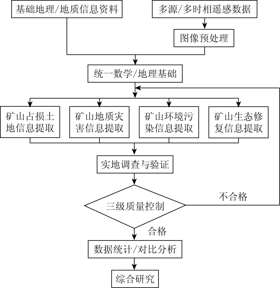
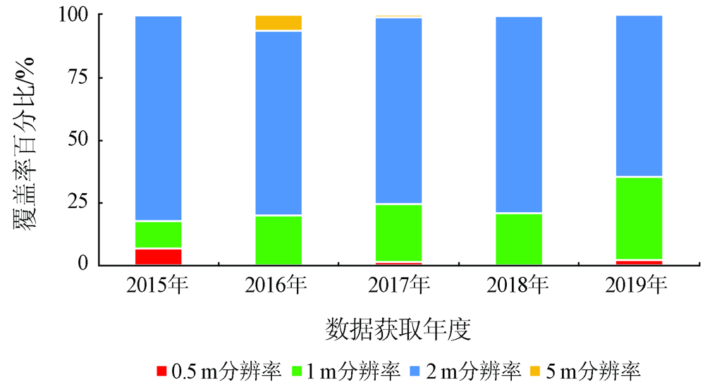
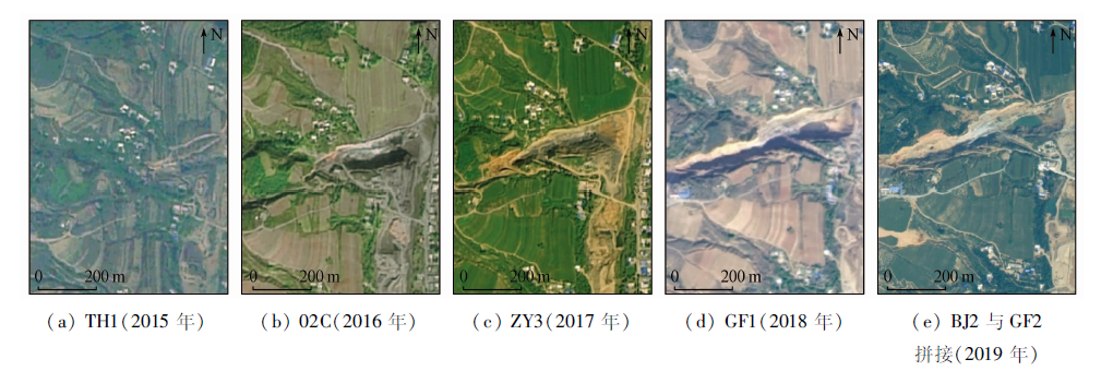
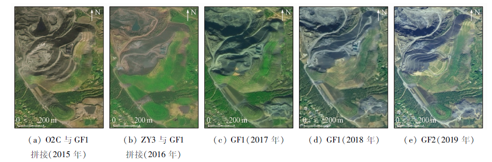
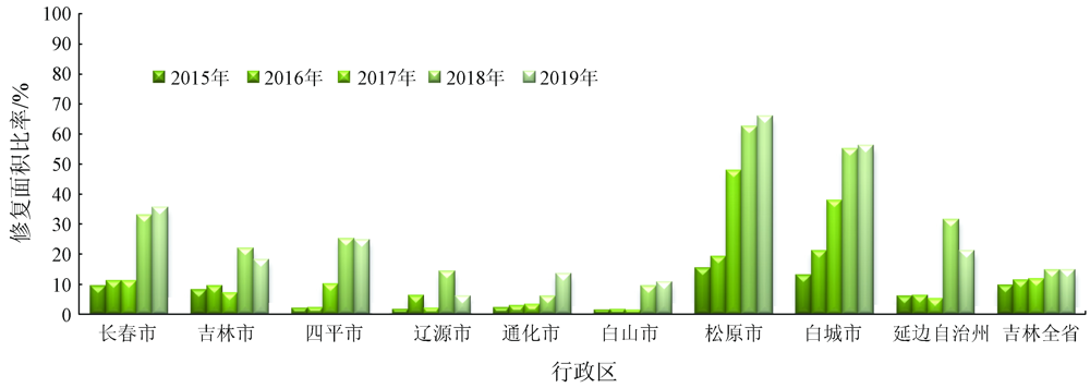
Abstract This study aims to understand the variation trend of the geological environment and the ecological restoration prospect of mines in Jilin Province. Using the 2015—2019 high-resolution remote sensing data from a domestic satellite and other multi-source information, this study carried out the remote sensing-based dynamic monitoring of the geological environment and ecological restoration of mines in Jilin Province by means of automatic information extraction, human-machine interactive interpretation, in-door comprehensive research, and field surveys and verification. The analysis of the changes in the geological environment and ecological restoration of the mines based on the monitoring results allowed for basically ascertaining the current situations and variation trend of the occupation of land resources by mines, damage to land resources by mines, and the geological disasters, environmental pollution, and ecological restoration of mines in Jilin Province. The analysis results are objective and accurate, indicating good application results of remote sensing-based monitoring. The results of this study can provide references and bases for further promoting the ecological protection and restoration engineering of mountains, rivers, forests, lakes, grass, and sand in Jilin Province.
|
| Keywords
remote sensing
mine development
mine geological environment
ecological restoration
dynamic monitoring
|
|
|
|
Issue Date: 21 September 2022
|
|
|
| [1] |
王国才. 吉林省矿山生态环境问题防治对策研究[D]. 长春: 东北师范大学, 2004:5-15.
|
| [1] |
Wang G C. Countermeasures for prevention and control of mining ecological environment problems in Jilin Province[D]. Changchun: Northeast Normal University, 2004:5-15.
|
| [2] |
胡明忠, 王小雨. 吉林省矿山生态环境防治对策研究[J]. 环境科学与管理, 2006, 31(3):132-134.
|
| [2] |
Hu R Z, Wang X Y. Study on prevention and control countermeasures of mine ecological environment in Jilin Province[J]. Environmental Science and Management, 2006, 31 (3):132-134.
|
| [3] |
刘传深. 吉林省矿山地质环境综合研究[D]. 长春: 吉林大学, 2006:18-38.
|
| [3] |
Liu C S. Comprehensive study on the geological environment of mines in Jilin Province[D]. Changchun: Jilin University, 2006:18-38.
|
| [4] |
陈力, 赵彦宁, 姚维斌. 吉林省不同类型矿山地质环境问题及恢复治理对策初探[J]. 地质与资源, 2010, 19(2):115-118.
|
| [4] |
Chen L, Zhao Y N, Yao W B. Geological environment problems of different types of mines in Jilin Province and countermeasures for restoration and treatment[J]. Geology and Resources, 2010, 19 (2):115-118.
|
| [5] |
张志, 杨金中, 张高华, 等. 生态文明视角下的湖北省东部矿山地质环境遥感调查与分析[J]. 中国地质调查, 2016, 3(5):21-27.
|
| [5] |
Zhang Z, Yang J Z, Zhang G H, et al. Remote sensing survey and analysis of mine geological environment in eastern Hubei Province from the perspective of ecological civilization[J]. China Geological Survey, 2016, 3(5):21-27.
|
| [6] |
杨金中, 聂洪峰, 荆青青. 初论全国矿山地质环境现状与存在问题[J]. 国土资源遥感. 2017, 29(2):1-7.doi: 10.6046/gtzyyg.2017.02.01.
doi: 10.6046/gtzyyg.2017.02.01
|
| [6] |
Yang J Z, Nie H F, Jing Q Q. Preliminary discussion on the current situation and existing problems of mining geological environment in China[J]. Remote Sensing for Land and Resources. 2017, 29(2):1-7.doi: 10.6046/gtzyyg.2017.02.01.
doi: 10.6046/gtzyyg.2017.02.01
|
| [7] |
王海庆, 李丽, 许文佳, 等. 西藏生产矿山在用土地面积遥感调查与分析[J]. 矿产保护与利用, 2019(5):146-150.
|
| [7] |
Wang H Q, Li L, Xu W J, et al. Remote sensing survey and analysis of land area in use of production mines in Tibet[J]. Mineral Protection and Utilization, 2019(5):146-150.
|
| [8] |
高俊华, 刘立, 杨金中, 等. 在建和生产矿山环境遥感监测图制作方法初探[J]. 地理空间信息, 2020, 18(6):70-72,7.
|
| [8] |
Gao J H, Liu L, Yang J Z, et al. Preliminary study on the method of making remote sensing monitoring map of mine environment under construction and production[J]. Geospatial Information, 2020, 18(6):70-72,7.
|
| [9] |
汪洁, 殷亚秋, 于航, 等. 基于RS和GIS的浙江省矿山地质环境遥感监测[J]. 国土资源遥感, 2020, 32(1):232-236.doi: 10.6046/gtzyyg.2020.01.31.
doi: 10.6046/gtzyyg.2020.01.31
|
| [9] |
Wang J, Yin Y Q, Yu H, et al. Remote sensing monitoring of mine geological environment in Zhejiang Province based on RS and GIS[J]. Remote Sensing for Land and Resources, 2020, 32(1):232-236.doi: 10.6046/gtzyyg.2020.01.31.
doi: 10.6046/gtzyyg.2020.01.31
|
| [10] |
姚维岭, 荆青青, 周英杰, 等. 基于遥感动态监测的山东省矿山地质环境恢复治理典型模式分析[J]. 矿产勘查, 2015, 6(5):627-634.
|
| [10] |
Yao W L, Jing Q Q, Zhou Y J, et al. Analysis on typical model of mine geological environment restoration and management in Shandong Province based on remote sensing dynamic monitoring[J]. Mineral Exploration, 2015, 6(5):627-634.
|
| [11] |
王耿明, 朱俊凤, 朱鑫, 等. 基于国产卫星的广东省矿山地质环境恢复治理遥感监测[J]. 地矿测绘, 2017, 33(2):4-7.
|
| [11] |
Wang G M, Zhu J F, Zhu X, et al. Remote sensing monitoring of mine geological environment restoration in Guangdong Province based on domestic satellite[J]. Geological and Mineral Mapping, 2017, 33(2):4-7.
|
| [12] |
耿娇娇, 赵志芳, 牛磊, 等. 矿山生态恢复治理与矿山开发关系分析——以X省域为例[J]. 中国高新科技, 2020(15):156-158.
|
| [12] |
Geng J J, Zhao Z F, Niu L, et al. Analysis of the relationship between mine ecological restoration and mining development:Taking X Province as an example[J]. China High Technology, 2020(15):156-158.
|
| [13] |
马世斌, 李生辉, 安萍, 等. 青海省聚乎更煤矿区矿山地质环境遥感监测及质量评价[J]. 国土资源遥感, 2015, 27(2):139-145.doi: 10.6046/gtzyyg.2015.02.22.
doi: 10.6046/gtzyyg.2015.02.22
|
| [13] |
Ma S B, Li S H, An P, et al. Remote sensing monitoring and quality evaluation of mine geological environment in Juhugeng coal mine area,Qinghai Province[J]. Remote Sensing for Land and Resources, 2015, 27(2):139-145.doi: 10.6046/gtzyyg.2015.02.22.
doi: 10.6046/gtzyyg.2015.02.22
|
| [14] |
高永志, 郑卫政, 初禹. 基于RS与GIS的黑龙江省矿山地质环境评价研究[J]. 地质与资源, 2016, 25(2):171-175.
|
| [14] |
Gao Y Z, Zheng W Z, Chu Y. Evaluation of mine geological environment in Heilongjiang Province based on RS and GIS[J]. Geology and Resources, 2016, 25(2):171-175.
|
| [15] |
赵玉灵. 基于层次分析法的矿山环境评价方法研究——以海南岛为例[J]. 国土资源遥感, 2020, 32(1):148-153.doi: 10.6046/gtzyyg.2020.01.20.
doi: 10.6046/gtzyyg.2020.01.20
|
| [15] |
Zhao Y L. Research on mine environmental assessment method based on analytic hierarchy process:A case study of Hainan Island[J]. Remote Sensing for Land and Resources, 2020, 32(1):148-153.doi: 10.6046/gtzyyg.2020.01.20.
doi: 10.6046/gtzyyg.2020.01.20
|
| [16] |
高俊华, 刘莎莎, 杨金中, 等. 基于遥感的露天煤矿集中区地质环境灰关联评价——以准格尔煤田为例[J]. 国土资源遥感, 2021, 33(1):183-190.doi: 10.6046/gtzyyg.2020006.
doi: 10.6046/gtzyyg.2020006
|
| [16] |
Gao J H, Liu S S, Yang J Z, et al. Remote sensing based grey correlation evaluation of geological environment in open pit coal mine concentration area:A case study of Zhungeer coalfield[J]. Remote Sensing for Land and Resources, 2021, 33(1):183-190.doi: 10.6046/gtzyyg.2020006.
doi: 10.6046/gtzyyg.2020006
|
| [17] |
贾汝颖, 薄桂秋. 吉林省矿产资源概况[J]. 中国地质, 1987(9):25-26,28.
|
| [17] |
Jia R Y, Bo G Q. General situation of mineral resources in Jilin Province[J]. Geology of China, 1987(9):25-26,28.
|
| [18] |
杨继红, 王冬艳. 浅谈吉林省矿产资源利用与可持续发展[J]. 吉林地质, 2010, 29(2):161-164.
|
| [18] |
Yang J H, Wang D Y. Discussion on the utilization and sustainable development of mineral resources in Jilin Province[J]. Jilin Geology, 2010, 29(2):161-164.
|
|
Viewed |
|
|
|
Full text
|
|
|
|
|
Abstract
|
|
|
|
|
Cited |
|
|
|
|
| |
Shared |
|
|
|
|
| |
Discussed |
|
|
|
|
 2022,
Vol. 34
2022,
Vol. 34
 ), ZOU Lianxue1, LONG Huan1, CHU Shuitao1