|
|
 |
|

|
|
|
Gray correlation evaluation of geological environment in the open-pit coal mine concentration area based on remote sensing:A case study of the Zhungeer Coalfield |
GAO Junhua1,2( ), LIU Shasha1,2, YANG Jinzhong3, ZHAO Mingpeng1,2, LIU Xinyue1,2, ZOU Lianxue1,2 ), LIU Shasha1,2, YANG Jinzhong3, ZHAO Mingpeng1,2, LIU Xinyue1,2, ZOU Lianxue1,2 |
1. Hunan Provincial General Station of Geological Environment Monitoring, Changsha 410007, China
2. Hunan Natural Resources Affairs Center, Changsha 410004, China
3. China Aero Geophysical Survey and Remote Sensing Center for Natural Resources, Beijing 100083, China |
|
|
|
|
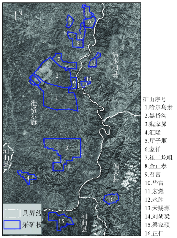
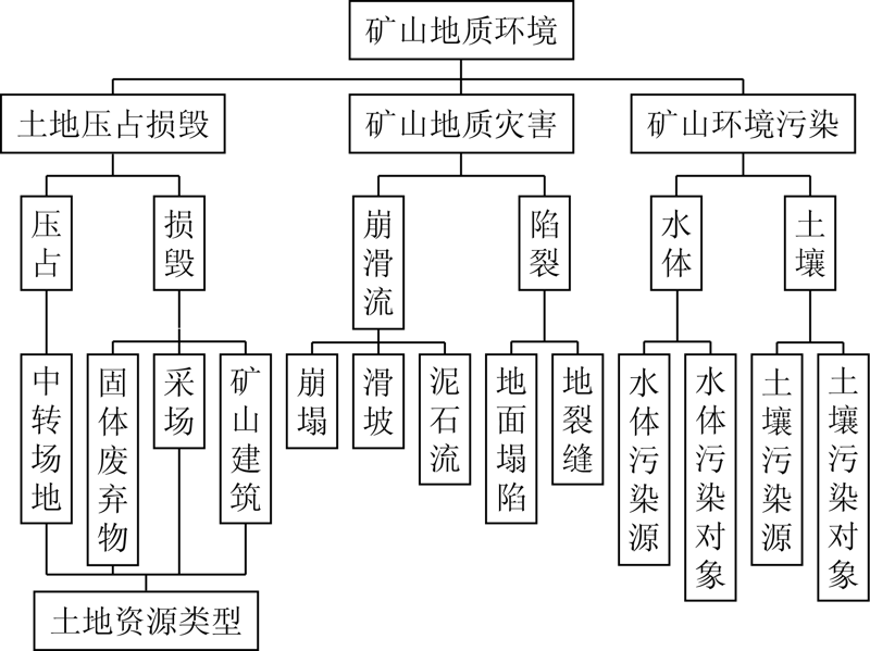
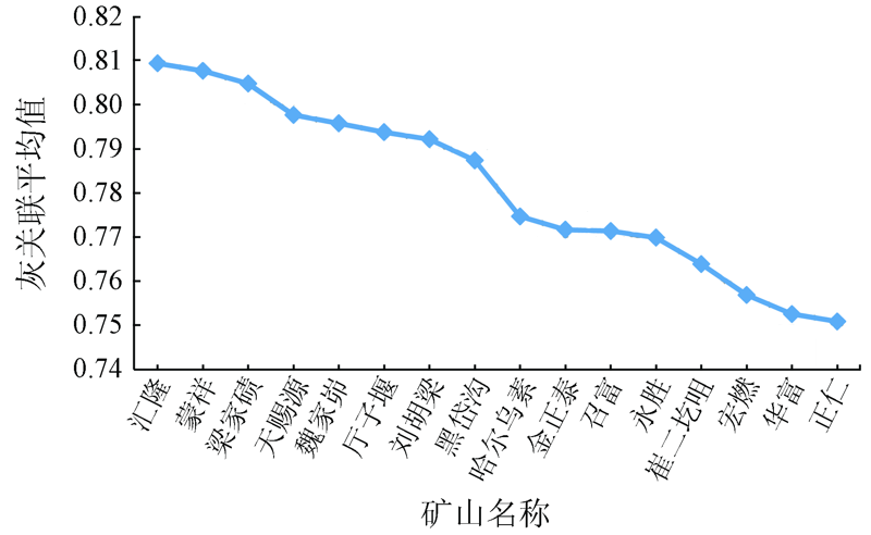
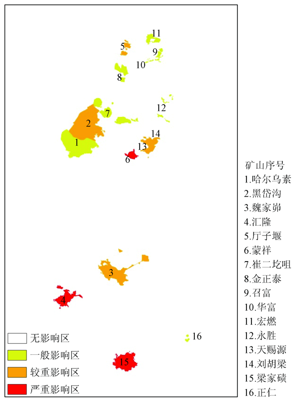
Abstract Satellite remote sensing technology has been used in China for more than ten years to obtain annual national mine geological environment remote sensing monitoring data. How to make full use of existing remote sensing monitoring results to carry out large-scale mining geological environmental assessment zoning is worthy of discussion and research. Therefore, the Zhungeer Coalfield was taken as the research area, and the artificial interpolation and hierarchical weighted improved gray correlation method was used to evaluate and analyze the geological environment of the 16 open-pit coal mines in the area, and the evaluation level divisions based on the mines were obtained. The evaluation conclusion is that the 3 mines of Huilong, Mengxiang and Liangjiaqi are severely affected by the environment, and the 5 mines of Tianciyuan, Weijiamao, Tingziyan, Liuhuliang and Heidaigou have relatively high environmental impacts. In the severe areas, 8 mines of Harwusu, Jinzhengtai, Zhaofu, Yongsheng, Cui’ergezui, Hongran, Huafu and Zhengren are general environmental impact areas, and other non-mine areas are the non-influenced areas. The evaluation results can reflect the geological environment status of the Zhungeer coalfield relatively objectively. Therefore, the gray correlation evaluation method of mine geological environment could be popularized and applied in a large area or even in whole China.
|
| Keywords
remote sensing
open pit coal mine
gray correlation method
mine geological environment evaluation
|
|
|
|
Issue Date: 18 March 2021
|
|
|
| [1] |
国土资源部. DZ/T0223—2011矿山地质环境保护与恢复治理方案编制规范[S]. 北京:国土资源部地质环境司, 2011.
|
| [1] |
Ministry of Land and Resources. DZ/T0223-2011 mine geological environmental protection and restoration and control plan preparation specifications[S]. Beijing:Department of Geology and Environment,Ministry of Land and Resources, 2011.
|
| [2] |
中国地质调查局. DD2014—05矿山地质环境调查评价规范[S]. 北京:中国地质调查局西安地质调查中心,中国地质环境监测院,山西省地质环境监测中心, 2014.
|
| [2] |
China Geological Survey. DD2014—05 specifications for mine geological environment survey and evaluation[S]. Beijing:China Geological Survey Xi’an Geological Survey Center,China Geological Environment Monitoring Institute,Shanxi Provincial Geological Environment Monitoring Center, 2014.
|
| [3] |
江松林, 孙世群, 王辉. 安徽省矿山环境质量综合评价研究[J]. 合肥工业大学学报. 2008,31(1):112-115.
|
| [3] |
Jiang S L, Sun S Q, Wang H. Comprehensive assessment of mine environmental quality of Anhui Province[J]. Journal of Hefei University of Technology, 2008,31(1):112-115.
|
| [4] |
陈俊奇. 基于RS和GIS的矿山地质环境调查与评价[D]. 北京:中国地质大学(北京), 2017.
|
| [4] |
Chen J Q. Survey and evaluation of mine geological environment based on RS and GIS[D]. Beijing:China University of Geosciences (Beijing), 2017.
|
| [5] |
杨梅忠, 刘亮, 高让礼. 模糊综合评判在矿山环境影响评价中的应用[J]. 西安科技大学学报, 2006,26(4):439-442.
|
| [5] |
Yang M Z, Liu L, Gao R L. Application of fuzzy synjournal evaluation to the environmental influence of the west mineral exploration[J]. Journal of Xi’an University of Science and Technology, 2006,26(4):439-442.
|
| [6] |
蒋复量, 周科平, 李向阳, 等. 基于集对分析的矿山地质环境影响评价研究[J], 矿冶工程, 2009,29(2):1-4.
|
| [6] |
Jiang F L, Zhou K P, Li X Y, et al. Study on assessment of geological environment impact in mines based on set pair analysis[J]. Mining and Metallurgical Engineering, 2009,29(2):1-4.
|
| [7] |
郑丽媛, 曹金亮, 张建萍. 矿山地质环境评价方法综述[J]. 华北自然资源, 2019(10):74-75.
|
| [7] |
Zheng L Y, Cao J L, Zhang J P. Summarization of assessment methods of mine geological environment[J]. North China Natural Resources, 2019(10):74-75.
|
| [8] |
辛建军, 张涛, 高慧卿, 等. 灰色系统理论在土地质量评价中的应用[J]. 农业系统科学与综合研究, 1987(12):39-46.
|
| [8] |
Xin J J, Zhang T, Gao H Q, et al. The application of grey system theory in land quality evaluation[J]. System Sciemces and Comprehensive Studies in Agriculture, 1987(12):39-46.
|
| [9] |
孟宪林, 孙丽欣, 周定, 等. 灰色理论在环境质量评价中的应用与完善[J]. 哈尔滨工业大学学报, 2002,10(5):700-702.
|
| [9] |
Meng X L, Sun L X, Zhou D, et al. Application and improvement of grey theory for assessment of environmental quality[J]. Journal of Harbin Institute of Technology, 2002,10(5):700-702.
|
| [10] |
肖晓柏, 许学工. 地表水环境质量灰关联评价方法探讨[J]. 环境科学与技术, 2003,5(3):34-36.
|
| [10] |
Xiao X B, Xu X G. A Study on grey associative analysis for assessment of surface water quality[J]. Environmental Science and Technology, 2003,5(3):34-36.
|
| [11] |
吴开亚, 李如忠, 陈晓剑. 区域生态环境评价的灰色关联投影模型[J]. 长江流域资源与环境, 2003,9(5):473-478.
|
| [11] |
Wu K Y, Li R Z, Chen X J. Grey relation projection model for the evaluation of regional eco-environmental quality[J]. Resources and Environment in the Yangtze River Basin, 2003,9(5):473-478.
|
| [12] |
刘德成, 靳小平, 周自梁. 灰色关联度分析法在北京通州区地裂缝灾害危险性评价中的应用[J]. 中国地质灾害与防治学报, 2010,9(3):73-76.
|
| [12] |
Liu D C, Jin X P, Zhou Z L. Application of grey degree of association evaluation method in ground fissures in Tongzhou District of Beijing[J]. Chinese Journal of Geological Hazard and Control, 2010,9(3):73-76.
|
| [13] |
黄永泉, 危超, 何景媛. 基于灰色关联分析法的江西省矿山环境质量评价[J]. 资源调查与环境, 2012,4(4):268-273.
|
| [13] |
Huang Y Q, Wei C, He J Y. Mine environmental quality evaluation by grey relational analysis method in Jiangxi Province[J]. Resources Survey and Environment, 2012,4(4):268-273.
|
| [14] |
刘方. 基于灰色关联度的模糊层次组合矿山地质环境评价模型研究[D]. 西安:长安大学, 2014.
|
| [14] |
Liu F. Study on fuzzy hierarchical combination mine geological environment assessment model based on grey correlation[D]. Xi’an:Chang’an University, 2014.
|
| [15] |
焦明连. 基于灰色聚类分析的矿山环境质量评价[J]. 煤矿开采, 2016,4(2):78-82.
|
| [15] |
Jiao M L. Evaluation of mine environment quality based on gray cluster analysis[J]. Coal Mining, 2016,4(2):78-82.
|
| [16] |
秦绪文, 杨金中, 康高峰, 等. 矿山遥感监测技术方法研究[M]. 北京: 测绘出版社, 2011.
|
| [16] |
Qin X W, Yang J Z, Kang G F, et al. Research on mine remote sensing monitoring technology[M]. Beijing: Surveying and Mapping Press, 2011.
|
| [17] |
杨金中, 秦绪文, 张志, 等. 矿山遥感监测理论方法与实践[M]. 北京: 测绘出版社, 2011.
|
| [17] |
Yang J Z, Qin X W, Zhang Z, et al. Theory and practice of remote sensing monitoring in mines[M]. Beijing: Surveying and Mapping Press, 2011.
|
| [18] |
杨金中, 聂洪峰, 荆青青. 初论全国矿山地质环境现状与存在问题[J]. 国土资源遥感, 2017,29(2):1-7.doi: 10.6046/gtzyyg.2017.02.01.
|
| [18] |
Yang J Z, Nie H F, Jing Q Q. Preliminary analysis of mine geo-environment status and existing problems in China[J]. Remote Sensing for Land and Resources, 2017,29(2):1-7.doi: 10.6046/gtzyyg.2017.02.01.
|
| [19] |
杨金中, 聂洪峰, 王海庆, 等. 中国矿山地质环境遥感监测(2015年)[M]. 北京: 测绘出版社, 2017.
|
| [19] |
Yang J Z, Nie H F, Wang H Q, et al. Remote sensing monitoring of mine geological environment in China (2015)[M]. Beijing: Surveying and Mapping Press, 2017.
|
| [20] |
杨金中, 王昊, 董双发, 等. 中国矿山地质环境遥感监测(2016年)[M]. 北京: 地质出版社, 2018.
|
| [20] |
Yang J Z, Wang H, Dong S F, et al. Remote sensing monitoring of mine geological environment in China (2016)[M]. Beijing: Geological Publishing House, 2018.
|
| [21] |
杨金中, 王晓红, 王海庆, 等. 中国矿山地质环境遥感监测(2017年)[M]. 北京: 地质出版社, 2019.
|
| [21] |
Yang J Z, Wang X H, Wang H Q, et al. Remote sensing monitoring of mine geological environment in China (2017)[M]. Beijing: Geological Publishing House, 2019.
|
| [22] |
王海庆, 武明德, 刘琼, 等. 山西某地矿业开发占用土地状况遥感监测[J]. 国土资源遥感, 2018,30(1):116-120.doi: 10.6046/gtzyyg.2018.01.16.
|
| [22] |
Wang H Q, Wu M D, Liu Q, et al. Remote sensing monitoring of mining land in a certain area of Shanxi Province[J]. Remote Sensing for Land and Resources, 2018,30(1):116-120.doi: 10.6046/gtzyyg.2018.01.16.
|
| [23] |
杨显华, 黄洁, 田立, 等. 矿山遥感监测在采空区稳定性分析中的应用[J]. 国土资源遥感, 2018,30(3):143-150.doi: 10.6046/gtzyyg.2018.03.20.
|
| [23] |
Yang X H, Huang J, Tian L, et al. Application of mine remote sensing monitoring to analysis of mine goaf stability[J]. Remote Sensing for Land and Resources, 2018,30(3):143-150.doi: 10.6046/gtzyyg.2018.03.20.
|
| [24] |
赵玉灵, 杨金中, 殷亚秋, 等. 海南岛东部滨海锆钛砂矿开发状况遥感监测与生态恢复治理对策研究[J]. 国土资源遥感, 2019,31(4):143-150.doi: 10.6046/gtzyyg.2019.04.19.
|
| [24] |
Zhao Y L, Yang J Z, Yin Y Q, et al. Research on remote sensing monitoring of zirconium-titanium sand mine exploitation and strategies of ecological restoration on the eastern beach of Hainan Island[J]. Remote Sensing for Land and Resources, 2019,31(4):143-150.doi: 10.6046/gtzyyg.2019.04.19.
|
| [25] |
汪洁, 殷亚秋, 于航, 等. 基于RS和GIS的浙江省矿山地质环境遥感监测[J]. 国土资源遥感, 2020,32(1):232-236.doi: 10.6046/gtzyyg.2020.01.31.
|
| [25] |
Wang J, Yin Y Q, Yu H, et al. Remote sensing monitoring of mine geological environment in Zhejiang Province based on RS and GIS[J]. Remote Sensing for Land and Resources, 2020,32(1):232-236.doi: 10.6046/gtzyyg.2020.01.31.
|
| [26] |
马世斌, 李生辉, 安萍, 等. 青海省聚乎更煤矿区矿山地质环境遥感监测及质量评价[J]. 国土资源遥感, 2015,27(2):139-145.doi: 10.6046/gtzyyg.2015.02.22.
|
| [26] |
Ma S B, Li S H, An P, et al. Remote sensing monitoring and quality evaluation for the mine geological environment of the Juhugeng coal mining area in Qinghai Province[J]. Remote Sensing for Land and Resources, 2015,27(2):139-145.doi: 10.6046/gtzyyg.2015.02.22.
|
| [27] |
赵玉灵. 基于层次分析法的矿山环境评价方法研究——以海南岛为例[J]. 国土资源遥感, 2020,32(1):148-153.doi: 10.6046/gtzyyg.2020.01.20.
|
| [27] |
Zhao Y L. Study and application of analytic hierarchy process of mine geological environment:A case study in Hainan Island[J]. Remote Sensing for Land and Resources, 2020,32(1):148-153.doi: 10.6046/gtzyyg.2020.01.20.
|
| [28] |
李文航, 龚建华. 遥感地表真实面积和垂直投影面积差异的定量化模拟[J]. 计算机应用研究, 2008,4(4):983-985.
|
| [28] |
Li W H, Gong J H. Quantitative simulation for difference between true surface area and planimetric area[J]. Application Research of Computers, 2008,4(4):983-985.
|
| [29] |
吴子武. 内蒙准格尔煤田地质特征[J]. 煤田地质与勘探, 1981(10):16-18.
|
| [29] |
Wu Z W. Geological characteristics of Zhungeer Coalfield,Inner Mongolia[J]. Coal Geology and Exploration, 1981(10):16-18.
|
| [30] |
高世华. 内蒙准格尔矿区的环境地质与灾害防治[C]// 第四届全国工程地质大会论文选集(三). 1992: 1168-1172.
|
| [30] |
Gao S H. Environmental geology and disaster prevention in Zhungeer mining area, Inner Mongolia[C]// Selected Papers of the Fourth National Engineering Geology Congress(3). 1992: 1168-1172.
|
| [31] |
张力, 王晓东. 准格尔煤田的生态安全问题及对策研究[J]. 华北科技学院学报, 2010(1):40-43.
url: http://d.wanfangdata.com.cn/Periodical_hbkygdzkxxxb201001011.aspx
|
| [31] |
Zhang L, Wang X D. Study on ecological security problems and countermeasures in Junger Coalfield[J]. Journal of North China Institute of Science and Technology, 2010(1):40-43.
|
| [32] |
罗振华. 准格尔煤田一期工程土地沙漠化环境影响预测方法[J]. 宁夏大学学报(自然科学版), 1993,9(3):42-47.
|
| [32] |
Luo Z H. A method for predicting the environmental impact of land desertification in the phase I project of Zhungeer Coalfield[J]. Journal of Ningxia University(Natural Science Edition), 1993,9(3):42-47.
|
| [33] |
湖南省质量技术监督局. DB43/T 1042—2015矿山地质环境综合防治方案编制规范[S]. 长沙:湖南省地质环境监测总站, 2015.
|
| [33] |
Hunan Provincial Bureau of Quality and Technical Supervision. DB43/T 1042—2015 specifications for the preparation of comprehensive prevention and control plans for mine geological environment[S]. Changsha:Hunan Provincial General Station for Geological Environment Monitoring, 2015.
|
|
Viewed |
|
|
|
Full text
|
|
|
|
|
Abstract
|
|
|
|
|
Cited |
|
|
|
|
| |
Shared |
|
|
|
|
| |
Discussed |
|
|
|
|
 2021,
Vol. 33
2021,
Vol. 33