|
|
|
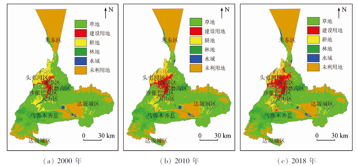
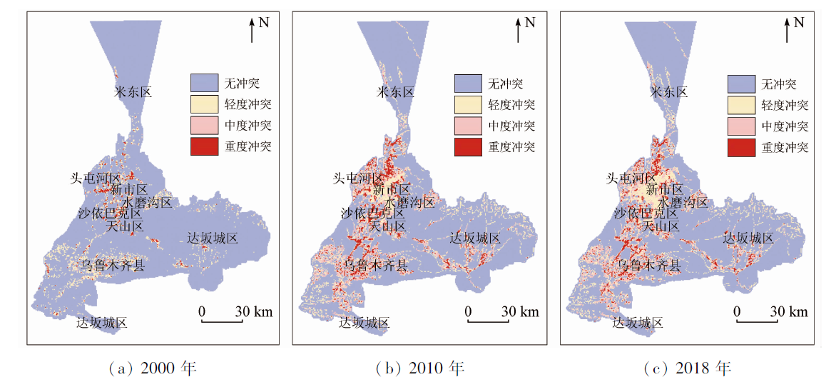
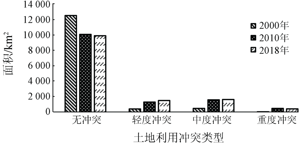
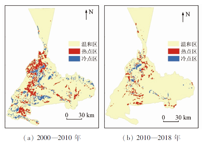
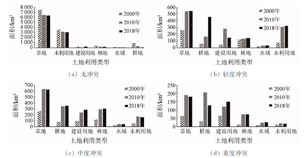
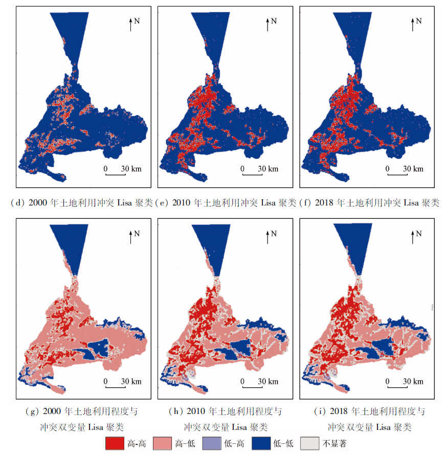
Abstract The identification of land-use conflicts is of great significance for maintaining the balance between ecological protection and the socio-economic development in oases in arid areas. Based on the data of land use status in 2000, 2010, and 2018 of Urumqi City-a valley oasis in the Urumqi River Basin, this paper constructs a comprehensive measurement model of land-use conflicts and further analyzes the distribution characteristics of the spatial pattern of land-use conflicts using the methods of spatial autocorrelation and cold/hot spot analysis. The results are as follows. ① The total area of land-use conflicts has increased year by year, and the area of lands with different land-use conflict levels is in the order of no conflict > moderate conflicts > mild conflicts > severe conflicts. Meanwhile, land-use conflicts are more liable to occur in grassland, cultivated land, construction land, and woodland. ② There is a significant spatial positive correlation between land-use conflicts in the study area, and the land-use conflicts are highly concentrated in terms of space. According to the analysis of cold and hot spots, it is found that from 2000 to 2018, the hot spots of land-use conflicts migrated from the northern part of the central urban area and southwestern parts to the eastern and southern parts of the urban area, with the distribution scope narrowing. In comparison, the cold spots of the land-use conflicts mainly concentrated inside the central urban area and the eastern and southern mountainous areas. ③ There is a positive spatial correlation between the land use degree and the land-use conflicts in the study area. C0/(C0+C) increased from 0.21 to 0.49 during 2000—2018, indicating that the spatial correlation weakened and the land-use conflicts are increasingly affected by random factors.
|
| Keywords
land-use conflict
spatial autocorrelation
cold/hot spot analysis
valley oasis
|
|
|
|
Corresponding Authors:
WU Zhaopeng
E-mail: 381615811@qq.com;wuzhaopengxj@sina.com
|
|
Issue Date: 23 December 2021
|
|
|
| [1] |
周晓艳, 宋亚男. 1982—2015年国际土地利用冲突研究文献计量分析[J]. 城市发展研究, 2017,24(1):100-108.
|
| [1] |
Zhou X Y, Song Y N. Bibliometric analysis of land use conflict research during 1982—2015[J]. Urban Studies, 2017,24(1):100-108.
|
| [2] |
于伯华, 吕昌河. 土地利用冲突分析:概念与方法[J]. 地理科学进展, 2006,25(3):106-115.
|
| [2] |
Yu B H, Lv C H. The progress and prospect of land use conflicts[J]. Progress in Geography, 2006,25(3):106-115.
|
| [3] |
Campbell D J, Gichohi H, Mwangi A, et al. Land use conflict in Kajiado District,Kenya[J]. Land Use Policy, 2000,17(4):337-348.
doi: 10.1016/S0264-8377(00)00038-7
url: https://linkinghub.elsevier.com/retrieve/pii/S0264837700000387
|
| [4] |
周德, 徐建春, 王莉. 近15年来中国土地利用冲突研究进展与展望[J]. 中国土地科学, 2015,29(2):21-29.
|
| [4] |
Zhou D, Xu J C, Wang L. Process of land use conflict research in China during the past fifteen years[J]. China Land Sciences, 2015,29(2):21-29.
|
| [5] |
刘贵利, 严奉天, 许顺才, 等. 城市发展中内外空间冲突与协调的战略选择——以石家庄市为例[J]. 地理研究, 2006(4):701-709,756.
|
| [5] |
Liu G L, Yan F T, Xu S C, et al. The strategic disposition between the conflict and coordination from internal and external space in urban development:Taking Shijiazhuang City as a case[J]. Geographical Research, 2006(4):701-709,756.
|
| [6] |
Zhao L Y, Peng Z R. Land system:An agent-based cellular automata model of land use change developed for transportation analysis[J]. Journal of Transport Geography, 2012,25(3):35-49.
doi: 10.1016/j.jtrangeo.2012.07.006
url: https://linkinghub.elsevier.com/retrieve/pii/S096669231200172X
|
| [7] |
谭术魁. 中国土地冲突的概念、特征与触发因素研究[J]. 中国土地科学, 2008,22(4):4-11.
|
| [7] |
Tan S K. Research on concept,characters and trigger factors of land conflicts in China[J]. China Land Science, 2008,22(4):4-11.
|
| [8] |
廖李红, 戴文远, 陈娟, 等. 平潭岛快速城市化进程中三生空间冲突分析[J]. 资源科学, 2017,39(10):1823-1833.
|
| [8] |
Liao L H, Dai W Y, Chen J, et al. Spatial conflict between ecological-production-living spaces on Pingtan Island during rapid urbanization[J]. Resources Science, 2017,39(10):1823-1833.
|
| [9] |
Siebert S. Agricultural,architectural and archaeological evidence for the role and ecological adaptation of a scattered mountain oasis in Oman[J]. Journal of Arid Environments, 2005,62(7):177-197.
doi: 10.1016/j.jaridenv.2004.09.023
url: https://linkinghub.elsevier.com/retrieve/pii/S0140196304002277
|
| [10] |
周骏. 基于社会燃烧理论的农村土地冲突原因及其治理研究[D]. 南昌:南昌大学, 2013.
|
| [10] |
Zhou J. Research on the cause and countermeasure of land conflicts based on social burning theory[D]. Nanchang:Nanchang University, 2013.
|
| [11] |
曾黎, 杨庆媛, 杨人豪, 等. 三峡库区生态屏障区景观格局优化——以重庆市江津区为例[J]. 生态学杂志, 2017,36(5):1364-1373.
|
| [11] |
Zeng L, Yang Q Y, Yang R H, et al. Landscape pattern optimization for ecological barrier in the Three Gorges Reservoir Area:A case study in Jiangjin,Chongqing[J]. Chinese Journal of Ecology, 2017,36(5):1364-1373.
|
| [12] |
徐馨裔, 刘志有, 董露, 等. 国土空间规划视角下产业结构与土地利用结构相互关系研究——以新疆乌鲁木齐市为例[J]. 生态经济, 2020,36(4):69-74.
|
| [12] |
XU X Y, Liu Z Y, Dong L, et al. Research on the mutual relationship between industrial structure and land utilization structure from the perspective of national land space planning:Taking Urumqi of Xinjiang as an example[J]. Ecological Economy, 2020,36(4):69-74.
|
| [13] |
裴彬, 潘韬. 土地利用系统动态变化模拟研究进展[J]. 地理科学进展, 2010,29(9):1060-1066.
|
| [13] |
Pei B, Pan T. Land use system dynamic modeling:Literature review and future research direction in China[J]. Progress in Geography, 2010,29(9):1060-1066.
|
| [14] |
杨国安, 甘国辉. 基于分形理论的北京市土地利用空间格局变化研究[J]. 系统工程理论与实践, 2004(10):131-137.
|
| [14] |
Yang G A, Gan G H. Land scape pattern change research of land use in Beijing based on fractal theory[J]. Systems Engineering-theory & Practice, 2004(10):131-137.
|
| [15] |
彭佳捷, 周国华, 唐承丽, 等. 基于生态安全的快速城市化地区空间冲突测度——以长株潭城市群为例[J]. 自然资源学报, 2012,27(9):1507-1519.
|
| [15] |
Peng J J, Zhou G A, Tang C L, et al. The analysis of spatial conflict measurement in fast urbanization region based on ecological security:A case study of Changsha Zhuzhou Xiangtan urban agglomeration[J]. Journal of Natural Resources, 2012,27(9):1507-1519.
|
| [16] |
秦坤. 基于生态安全的土地利用空间冲突研究——以武汉城市圈[D]. 武汉:武汉大学, 2017.
|
| [16] |
Qin K. The analysis of land use spatial conflicts based on ecological security:A case study of the urban agglomeration around Wuhan[D]. Wuhan:Wuhan University, 2017.
|
| [17] |
周国华, 彭佳捷. 空间冲突的演变特征及影响效应——以长株潭城市群为例[J]. 地理科学进展, 2012,31(6):717-723.
|
| [17] |
Zhou G H, PPeng J J. The evolution characteristic sand influence effect of spatial conflict:A case study of Changsha-Zhuzhou-Xiangtan urban agglomeration[J]. Progress in Geography, 2012,31(6):717-723.
|
| [18] |
王思远, 刘纪远, 张增祥, 等. 中国土地利用时空特征分析[J]. 地理学报, 2001(6):631-639.
doi: 10.11821/xb200106001
|
| [18] |
Wang S Y, Liu J Y, Zhang Z X, et al. Analysis on spatial-temporal features of land use in China[J]. Acta Geographica Sinica, 2001(6):631-639.
doi: 10.11821/xb200106001
|
| [19] |
桑潇, 国巧真, 潘应阳, 等. 基于TM和OLI数据山西省潞城市土地利用动态变化分析与预测[J]. 国土资源遥感, 2018,30(2):125-131.doi: 10.6046/gtzyyg.2018.02.17.
doi: 10.6046/gtzyyg.2018.02.17
|
| [19] |
Sang X, Guo Q Z, Pan Y Y, et al. Research on land use dynamic change and prediction in Lucheng City of Shanxi Province based on TM and OLI[J]. Remote Sensing for Land and Resources, 2018,30(2):125-131.doi: 10.6046/gtzyyg.2018.02.17.
doi: 10.6046/gtzyyg.2018.02.17
|
| [20] |
王秀兰, 包玉海. 土地利用动态变化研究方法探讨[J]. 地理科学进展, 1999(1):3-5.
|
| [20] |
Wang X L, Bao Y H. Study on the methods of land use dynamic change research[J]. Progress in Geography, 1999(1):3-5.
|
| [21] |
张军峰, 孟凡浩, 包安明, 等. 新疆孔雀河流域人工绿洲近40年土地利用/覆被变化[J]. 中国沙漠, 2018,38(3):664-672.
|
| [21] |
Zhang J F, Meng F H, Bao A M, et al. LUCC analysis of the upstream of the Kongqi River,Xinjiang China[J]. Journal of Desert Research, 2018,38(3):664-672.
|
| [22] |
唐宏, 乔旭宁, 杨德刚, 等. 土地利用变化时空特征与区域发展关系研究——以渭干河流域为例[J]. 干旱地区农业研究, 2012,30(3):205-213.
|
| [22] |
Tang H, Qiao X N, Yang D G, et al. Characteristics of temporal and spatial dynamic changes of land use and their relationship with regional development——A case study in the Weigan River Basin[J]. Agricultural Research in the Arid Areas, 2012,30(3):205-213.
|
| [23] |
游巍斌, 何东进, 巫丽芸, 等. 武夷山风景名胜区景观生态安全度时空分异规律[J]. 生态学报, 2011,31(21):6317-6327.
|
| [23] |
You W B, He D J, Wu L Y, et al. Temporal spatial differentiation and its change in the landscape ecological security of Wuyishan Scenery District[J]. Acta Ecologica Sinica, 2011,31(21):6317-6327.
|
|
Viewed |
|
|
|
Full text
|
|
|
|
|
Abstract
|
|
|
|
|
Cited |
|
|
|
|
| |
Shared |
|
|
|
|
| |
Discussed |
|
|
|
|
 2021,
Vol. 33
2021,
Vol. 33
 ), WU Zhaopeng1,2(