|
|
 |
|

|
|
|
Precise mapping of open beach areas by combining laser point clouds and stereo optical satellite imagery |
WANG Zongwei1,2( ), LU Minyan1,2, FAN Yilin1,2 ), LU Minyan1,2, FAN Yilin1,2 |
1. Jiangsu Province Surveying and Mapping Engineering Institute, Nanjing 210013, China
2. Key Laboratory of Land Satellite Remote Sensing Application, Ministry of Natural Resources, Nanjing 210013, China |
|
|
|
|
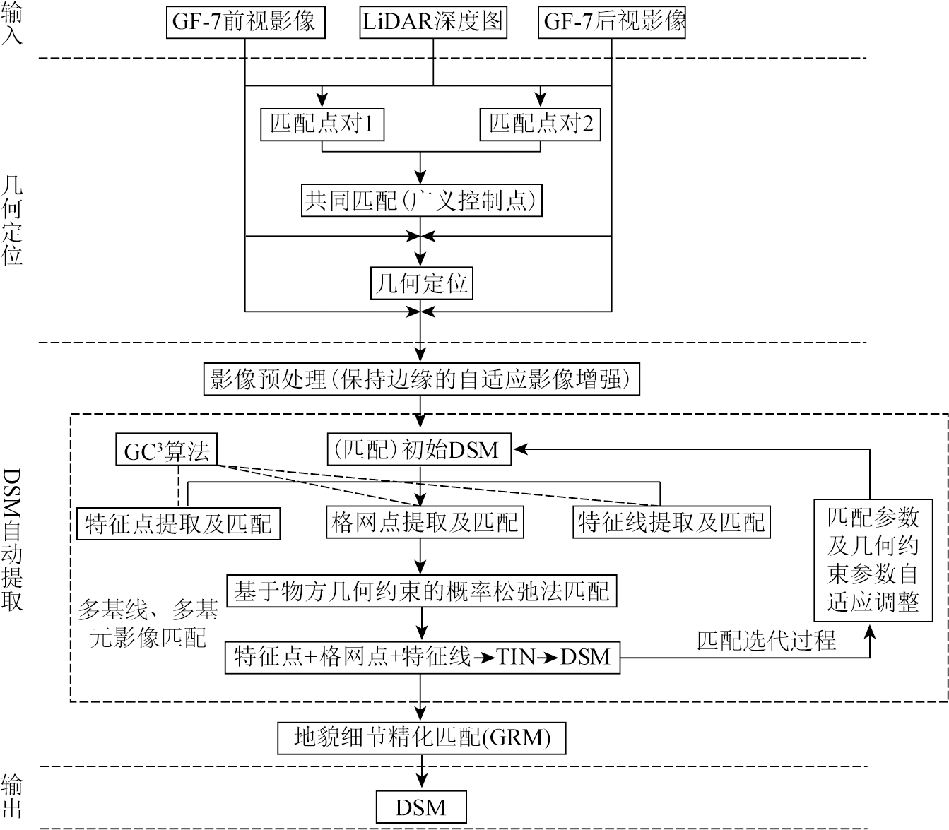
Abstract This study aims to overcome the challenges of precise mapping of open beach areas using stereo satellite imagery. Based on the complementary characteristics of stereo optical satellite imagery and light detection and ranging (LiDAR) point cloud data in geometric positioning, this study developed a high-precision mapping method that employed high-precision LiDAR point cloud data for generalized control. First, the LiDAR depth map was matched with the optical satellite images to extract corresponding point pairs for generalized control. Then, the images and control points were used as inputs for adjustment to achieve an accurate geometric positioning of the images. Finally, guided by LiDAR point cloud data and in combination with multi-baseline and multi-primitive matching algorithms and the geomorphologic refined matching (GRM) algorithm, a high-precision digital surface model (DSM) for open beach areas was automatically extracted. The results of this study indicate that the combined use of laser point clouds and stereo satellite imagery, along with photogrammetric technology, allows for the quick and accurate preparation of high-precision topographic maps of open beach areas. This study provides valuable guidance for the precise mapping of open beach areas.
|
| Keywords
stereo optical satellite
LiDAR point cloud
geometric positioning
DSM automatic extraction
|
|
|
|
Issue Date: 23 December 2024
|
|
|
| [1] |
Zhu Q, Jiang W, Zhu Y, et al. Geometric accuracy improvement method for high-resolution optical satellite remote sensing imagery combining multi-temporal SAR imagery and GLAS data[J]. Remote Sensing, 2020, 12(3):568.
|
| [2] |
付琨, 孙显, 仇晓兰, 等. 遥感大数据条件下多星一体化处理与分析[J]. 遥感学报, 2021, 25(3):691-707.
|
| [2] |
Fu K, Sun X, Qiu X L, et al. Multi-satellite integrated processing and analysis method under remote sensing big data[J]. National Remote Sensing Bulletin, 2021, 25(3):691-707.
|
| [3] |
Tang S, Wu B, Zhu Q. Combined adjustment of multi-resolution satellite imagery for improved geo-positioning accuracy[J]. ISPRS Journal of Photogrammetry and Remote Sensing, 2016, 114:125-136.
|
| [4] |
李红帅. 基于激光点云图像融合的三维重建方法与应用[D]. 桂林: 桂林电子科技大学, 2021.
|
| [4] |
Li H S. Three-dimensional reconstruction method and application based on laser point cloud image fusion[D]. Guilin: Guilin University of Electronic Technology, 2021.
|
| [5] |
Dai J, Li D F, Li Y Q, et al. Mobile robot localization and mapping algorithm based on the fusion of image and laser point cloud[J]. Sensors, 2022, 22(11):4114.
|
| [6] |
Chan S H, Wu P T, Fu L C. Robust 2D indoor localization through laser SLAM and visual SLAM fusion[C]// 2018 IEEE International Conference on Systems,Man,and Cybernetics (SMC).Miyazaki,Japan.IEEE, 2018:1263-1268.
|
| [7] |
Zhang L, Wang G, Sun W. Automatic extraction of building geometries based on centroid clustering and contour analysis on oblique images taken by unmanned aerial vehicles[J]. International Journal of Geographical Information Science, 2022, 36(3):453-475.
|
| [8] |
Zhou G, Zhou X. Seamless fusion of LiDAR and aerial imagery for building extraction[J]. IEEE Transactions on Geoscience and Remote Sensing, 2014, 52(11):7393-7407.
|
| [9] |
Abayowa B O, Yilmaz A, Hardie R C. Automatic registration of optical aerial imagery to a LiDAR point cloud for generation of city models[J]. ISPRS Journal of Photogrammetry and Remote Sensing, 2015, 106:68-81.
|
| [10] |
Su Y J, Guo Q H, Ma Q, et al. SRTM DEM correction in vegetated mountain areas through the integration of spaceborne LiDAR,airborne LiDAR,and optical imagery[J]. Remote Sensing, 2015, 7(9):11202-11225.
|
| [11] |
Li J Y, Hu Q W, Ai M Y. RIFT:Multi-modal image matching based on radiation-variation insensitive feature transform[J]. IEEE Transactions on Image Processing:A Publication of the IEEE Signal Processing Society, 2019:3296-3310.
|
| [12] |
Ye Y, Shan J, Bruzzone L, et al. Robust registration of multimodal remote sensing images based on structural similarity[J]. IEEE Transactions on Geoscience and Remote Sensing, 2017, 55(5):2941-2958.
|
| [13] |
Ye Y X, Bruzzone L, Shan J, et al. Fast and robust matching for multimodal remote sensing image registration[J]. IEEE Transactions on Geoscience and Remote Sensing, 2019, 57(11):9059-9070.
|
| [14] |
樊仲藜, 张力, 王庆栋, 等. SAR影像和光学影像梯度方向加权的快速匹配方法[J]. 测绘学报, 2021, 50(10):1390-1403.
doi: 10.11947/j.AGCS.2021.20200587
|
| [14] |
Fan Z L, Zhang L, Wang Q D, et al. A fast matching method of SAR and optical images using angular weighted orientated gradients[J]. Acta Geodaetica et Cartographica Sinica, 2021, 50(10):1390-1403.
doi: 10.11947/j.AGCS.2021.20200587
|
| [15] |
张力, 刘玉轩, 孙洋杰, 等. 数字航空摄影三维重建理论与技术发展综述[J]. 测绘学报, 2022, 51(7):1437-1457.
doi: 10.11947/j.AGCS.2022.20220130
|
| [15] |
Zhang L, Liu Y X, Sun Y J, et al. A review of developments in the theory and technology of three-dimensional reconstruction in digi-tal aerial photogrammetry[J]. Acta Geodaetica et Cartographica Sinica, 2022, 51(7):1437-1457.
|
| [16] |
张力, 艾海滨, 许彪, 等. 基于多视影像匹配模型的倾斜航空影像自动连接点提取及区域网平差方法[J]. 测绘学报, 2017, 46(5):554-564.
doi: 10.11947/j.AGCS.2017.20160571
|
| [16] |
Zhang L, Ai H B, Xu B, et al. Automatic tie-point extraction based on multiple-image matching and bundle adjustment of large block of oblique aerial images[J]. Acta Geodaetica et Cartographica Sinica, 2017, 46(5):554-564.
doi: 10.11947/j.AGCS.2017.20160571
|
|
Viewed |
|
|
|
Full text
|
|
|
|
|
Abstract
|
|
|
|
|
Cited |
|
|
|
|
| |
Shared |
|
|
|
|
| |
Discussed |
|
|
|
|
 2024,
Vol. 36
2024,
Vol. 36