|
|
 |
|

|
|
|
Spatial-temporal change and prediction of carbon stock in the ecosystem of Xi’an based on PLUS and InVEST models |
YANG Lianwei1( ), ZHAO Juan1, ZHU Jiatian1, LIU Lei1, ZHANG Ping1,2() ), ZHAO Juan1, ZHU Jiatian1, LIU Lei1, ZHANG Ping1,2() |
1. School of Environmental and Chemical Engineering, Xi’an Polytechnic University, Xi’an 710600, China
2. Shaanxi Key Laboratory of Land Consolidation, Xi’an 710075, China |
|
|
|
|
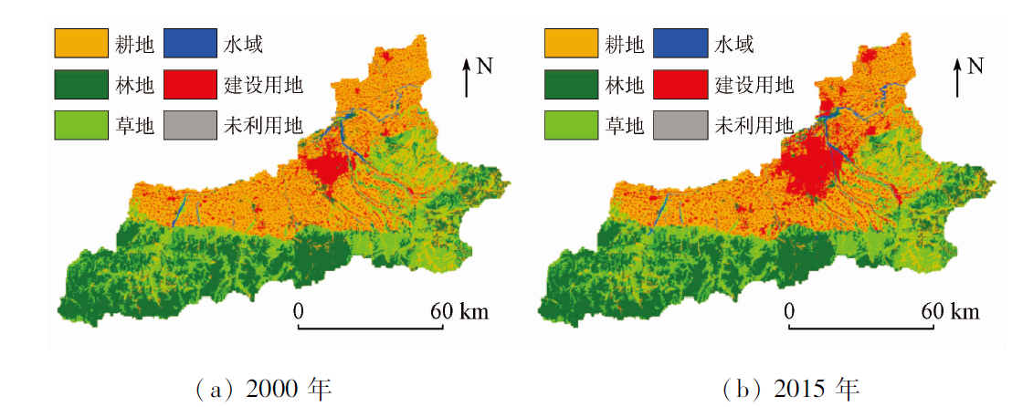
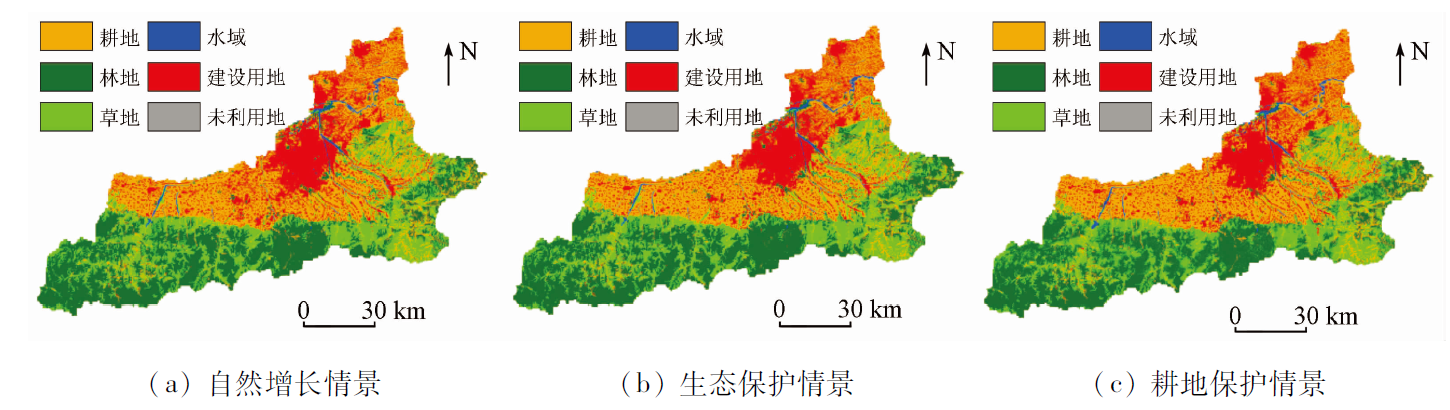
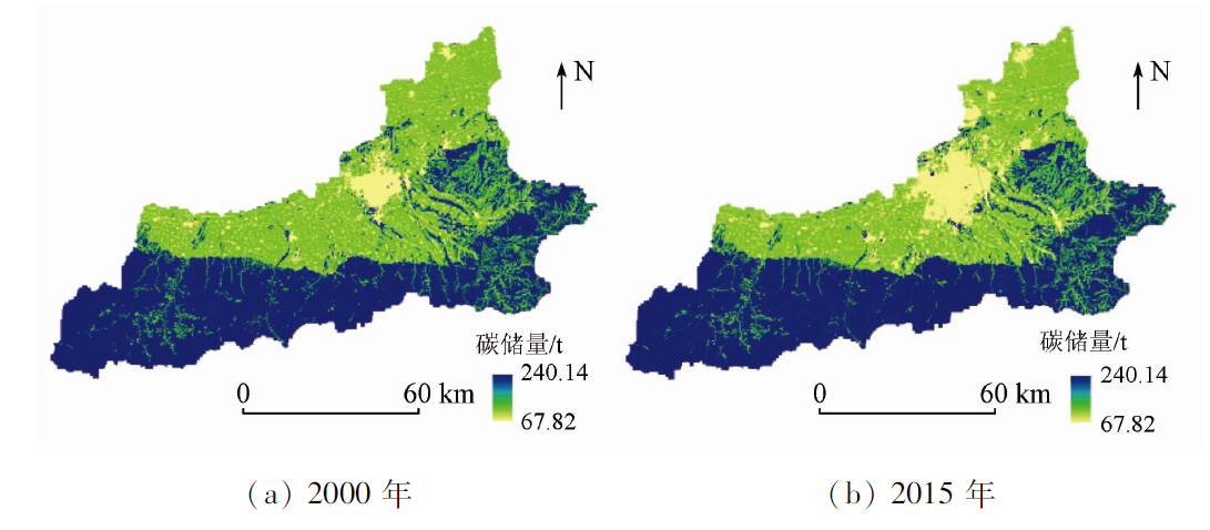
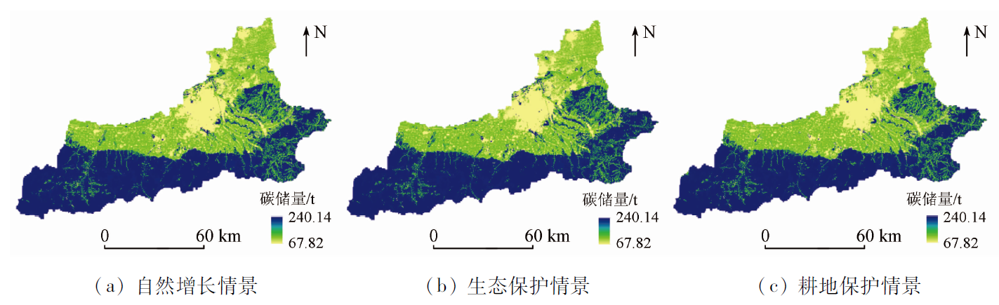
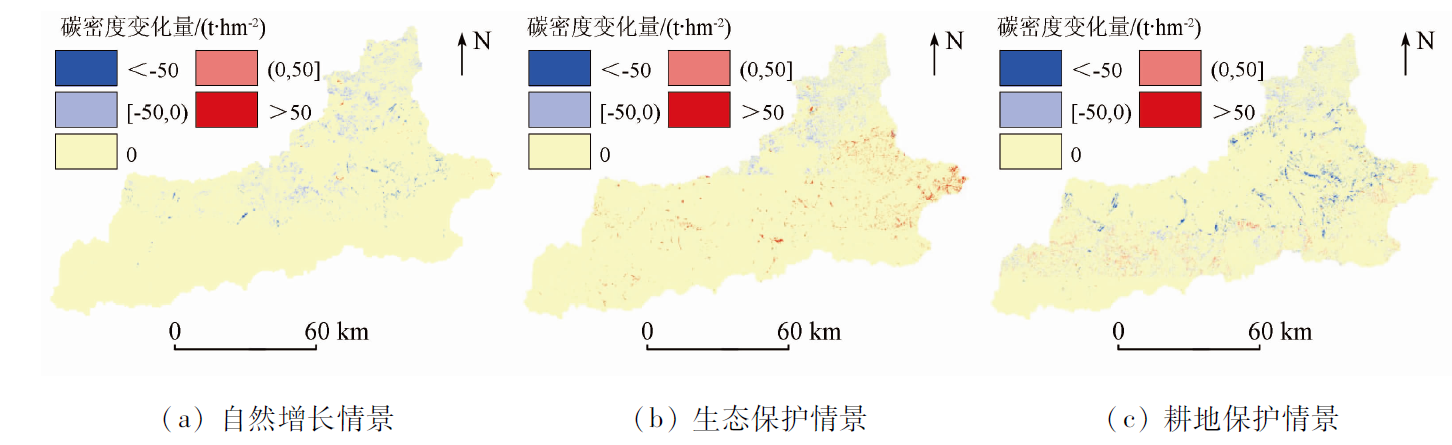
Abstract Land use can cause carbon stock changes by affecting the structural layouts and functions of terrestrial ecosystems. Therefore, research on the relationship between land use changes and carbon stock is greatly significant for optimizing regional land use patterns and making sensible ecological decisions. This study predicted the spatial-temporal changing characteristics of land use and carbon stock in Xi’an under different scenarios in the future using the PLUS and InVEST models and investigated the impact of land use changes on carbon stock. The results are as follows. From 2000 to 2015, the expansion of construction land and the transfer of high-carbon-density land reduced the carbon stock of Xi’an by 2.49×10⁶ t. From 2015 to 2030 the carbon stock continuously declined by 2.14×10⁶ t in the natural growth scenario, and the carbon stock of Xi’an will increase by 6.92×10⁵ t in the ecological protection scenario due to the measures taken for land protection and transfer control. In the cultivated land protection scenario, the cultivated land will be protected, but the high-carbon-density land such as woodland and grassland will be affected by the expansion of construction land during 2015—2030, reducing the carbon stock to 1.60×10⁸ t. As indicated by the analysis of carbon density change, ecological protection measures can increase the changing rate of carbon density. Compared with the natural growth scenario, the ecological protection scenario will increase the proportion of areas with increased carbon density (mainly high-increase areas) from 0.05% to 1.57%. By contrast, under the cultivated land protection scenario, the carbon density will decrease, and high-increase areas will be transformed into moderately-high-increase areas. Based on cultivated land protection, it is necessary to take proper ecological protection measures in the future land use planning of Xi’an to control the rapid expansion of construction land from cultivated and forest land. Optimizing land use patterns can effectively reduce the loss of carbon stock, improve the level of regional carbon stock, and achieve regional sustainable development.
|
| Keywords
land use change
PLUS model
InVEST model
Xi’an City
carbon storage
|
|
|
|
Issue Date: 27 December 2022
|
|
|
| [1] |
张燕, 师学义, 唐倩. 不同土地利用情景下汾河上游地区碳储量评估[J]. 生态学报, 2021, 41(1):360-373.
|
| [1] |
Zhang Y, Shi X Y, Tang Q. Carbon storage assessment in the upper reaches of the Fenhe River under different land use scenarios[J]. Acta Ecologica Sinica, 2021, 41(1):360-373.
|
| [2] |
朱志强, 马晓双, 胡洪. 基于耦合FLUS-InVEST模型的广州市生态系统碳储量时空演变与预测[J]. 水土保持通报, 2021, 41(2):222-229.
|
| [2] |
Zhu Z Q, Ma X S, Hu H. Spatio-temporal evolution and prediction of ecosystem carbon stocks in Guangzhou City by coupling FLUS-InVEST models[J]. Bulletin of Soil and Water Conservation, 2021, 41(2):222-229.
|
| [3] |
刘洋, 张军, 周冬梅, 等. 基于InVEST模型的疏勒河流域碳储量时空变化研究[J]. 生态学报, 2021, 41(10):4052-4065.
|
| [3] |
Liu Y, Zhang J, Zhou D M, et al. Temporal and spatial variation of carbon storage in the Shule River basin on InVEST model[J]. Acta Ecologica Sinca, 2021, 41(10):4052-4065.
|
| [4] |
Jiang W G, Deng Y, Tang Z H, et al. Modelling the potential impacts of urban ecosystem changes on carbon storage under different scenarios by linking the CLUE-S and the InVEST models[J]. Ecological Modelling, 2017, 345:30-40.
doi: 10.1016/j.ecolmodel.2016.12.002
url: https://linkinghub.elsevier.com/retrieve/pii/S0304380016307554
|
| [5] |
韩艳莉, 陈克龙, 于德永. 土地利用变化对青海湖流域生境质量的影响[J]. 生态环境学报, 2019, 28(10):2035-2044.
|
| [5] |
Han Y L, Chen K L, Yu D Y. Evaluation on the impact of land use change on habitat quality in Qinghai Lake basin[J]. Ecology and Environmental Sciences, 2019, 28(10):2035-2044.
|
| [6] |
王耕, 王佳雯. 丹东沿海地区土地利用变化对生境质量的影响研究[J]. 生态环境学报, 2021, 30(3):621-630.
|
| [6] |
Wang G, Wang J W. Study on the impact of land use change on habitat quality in Dandong coastal area[J]. Ecology and Environmental Sciences, 2021, 30(3):621-630.
|
| [7] |
朱文博, 张静静, 崔耀平, 等. 基于土地利用变化情景的生态系统碳储量评估——以太行山淇河流域为例[J]. 地理学报, 2019, 74(3):446-459.
doi: 10.11821/dlxb201903004
|
| [7] |
Zhu W B, Zhang J J, Cui Y P, et al. Assessment of territorial ecosystem carbon storage based on land use change scenario:A case study in Qihe River basin[J]. Acta Geographica Sinica, 2019, 74(3):446-459.
|
| [8] |
Zhao M, He Z, Du J, et al. Assessing the effects of ecological engineering on carbon storage by linking the CA-Markov and InVEST models[J]. Ecological Indicators, 2019, 98:29-38.
doi: 10.1016/j.ecolind.2018.10.052
url: https://linkinghub.elsevier.com/retrieve/pii/S1470160X18308239
|
| [9] |
史名杰, 武红旗, 贾宏涛, 等. 基于MCE-CA-Markov和InVEST模型的伊犁谷地碳储量时空演变及预测[J]. 农业资源与环境学报, 2021, 38(6):1010-1019.
|
| [9] |
Shi M J, Wu H Q, Jia H T, et al. Temporal and spatial evolution and prediction of carbon stocks in Yili Valley based on MCE-CA-Markov and InVEST models[J]. Journal of Agricultural Resources and Environment, 2021, 38(6):1010-1019.
|
| [10] |
吴佩君, 刘小平, 黎夏, 等. 基于InVEST模型和元胞自动机的城市扩张对陆地生态系统碳储量影响评估——以广东省为例[J]. 地理与地理信息科学, 2016, 32(5):22-28.
|
| [10] |
Wu P J, Liu X P, Li X, et al. Impact of urban expansion on carbon storage in terrestrial ecosystems based on InVEST model and CA:A case study of Guangdong Province,China[J]. Geography and Geo-Information Science, 2016, 32(5):22-28.
|
| [11] |
Liang Y, Liu L, Huang J. Integrating the SD-CLUE-S and InVEST models into assessment of oasis carbon storage in northwestern China[J]. Plos One, 2017, 12(2):e0172494.
doi: 10.1371/journal.pone.0172494
url: https://dx.plos.org/10.1371/journal.pone.0172494
|
| [12] |
Liang X, Guan Q, Clarke K C, et al. Understanding the drivers of sustainable land expansion using a patch-generating land use simulation (PLUS) model:A case study in Wuhan,China[J]. Computers,Environment and Urban Systems, 2021, 85:101569.
doi: 10.1016/j.compenvurbsys.2020.101569
url: https://linkinghub.elsevier.com/retrieve/pii/S0198971520303021
|
| [13] |
Liu X P, Liang X, Li X, et al. A future land use simulation model (FLUS) for simulating multiple land use scenarios by coupling human and natural effects[J]. Landscape and Urban Planning, 2017, 168:94-116.
doi: 10.1016/j.landurbplan.2017.09.019
url: https://linkinghub.elsevier.com/retrieve/pii/S0169204617302396
|
| [14] |
喇蕗梦, 勾蒙蒙, 李乐, 等. 三峡库区生态系统服务权衡时空动态与情景模拟:以秭归县为例[J]. 生态与农村环境学报, 2021, 37(11):1368-1377.
|
| [14] |
La L M, Gou M M, Li L, et al. Spatiotemporal dynamics and scenarios analysis on trade-offs between ecosystem Service in three gorges reservoir area:A case study of Zigui County[J]. Journal of Ecology and Rural Environment, 2021, 37(11):1368-1377.
|
| [15] |
柯新利, 普鹍鹏, 杨柏寒, 等. 耕地保护对生态系统水源涵养功能的影响——以武汉市为例[J]. 水土保持研究, 2018, 25(1):391-396.
|
| [15] |
Ke X L, Pu K P, Yang B H, et al. Impacts of cultivated land protection on water retention fuction of ecosysteam:A case study in Wuhan[J]. Research of Soil and Water Conservation, 2018, 25(1):391-396.
|
| [16] |
Babbar D, Areendran G, Sahana M, et al. Assessment and prediction of carbon sequestration using Markov chain and InVEST model in Sariska Tiger Reserve,India[J]. Journal of Cleaner Production, 2021, 278:123333.
doi: 10.1016/j.jclepro.2020.123333
url: https://linkinghub.elsevier.com/retrieve/pii/S0959652620333783
|
| [17] |
Sharp R, Douglass J, Wolny S, et al. InVEST 3.8.9 User’s Guide[Z]. The Natural Capital Project,Stanford University,University of Minnesota,the Nature Conservancy,and World Wildlife Fund, 2020.
|
| [18] |
柯新利, 唐兰萍. 城市扩张与耕地保护耦合对陆地生态系统碳储量的影响——以湖北省为例[J]. 生态学报, 2019, 39(2):672-683.
|
| [18] |
Ke X L, Tang L P. Impact of cascading processes of urban expansion and cropland reclamation on the ecosystem of a carbon storage service in Hubei Province,China[J]. Acta Ecologica Sinica, 2019, 39(2):672-683.
|
| [19] |
Lyu R F, Mi L N, Zhang J M, et al. Modeling the effects of urban expansion on regional carbon storage by coupling SLEUTH-3r model and InVEST model[J]. Ecological Research, 2019, 34(3):380-393.
doi: 10.1111/1440-1703.1278
url: https://onlinelibrary.wiley.com/doi/10.1111/1440-1703.1278
|
|
Viewed |
|
|
|
Full text
|
|
|
|
|
Abstract
|
|
|
|
|
Cited |
|
|
|
|
| |
Shared |
|
|
|
|
| |
Discussed |
|
|
|
|
 2022,
Vol. 34
2022,
Vol. 34