|
|
|
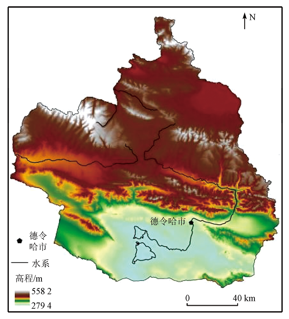
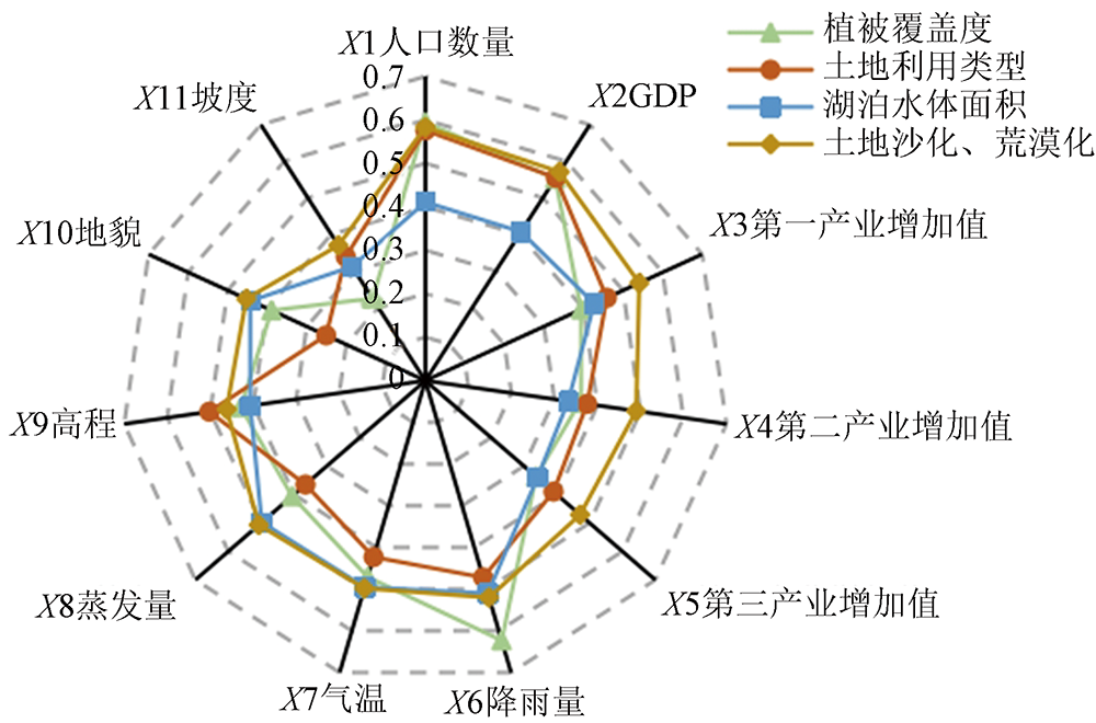
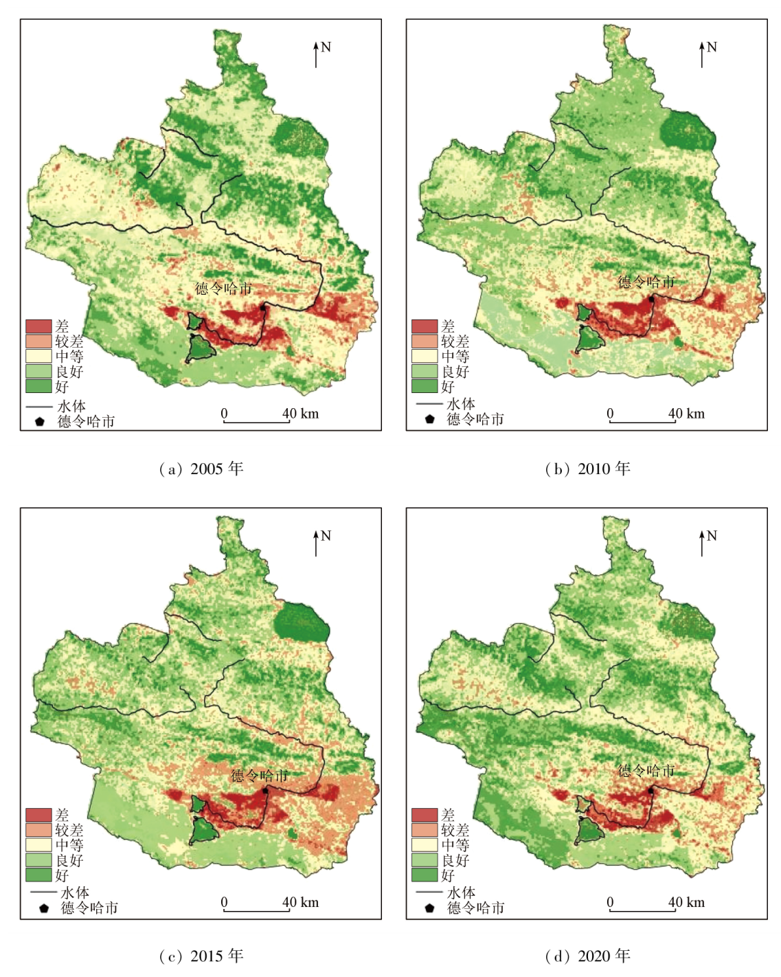
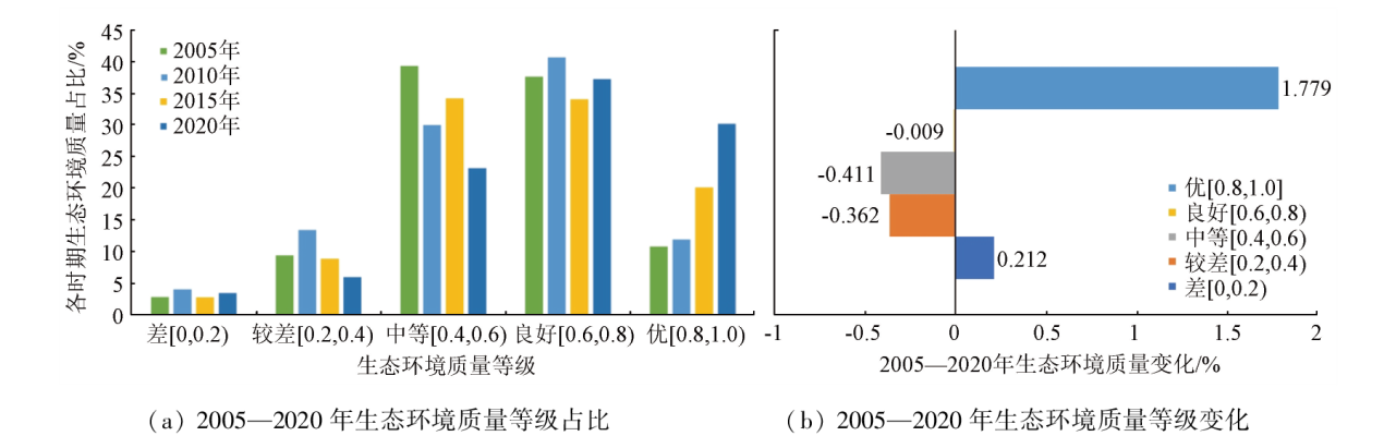
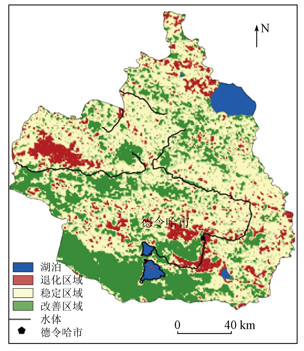
Abstract This study aims to provide a guide for the optimal management of land use and ecological environment in the Bayin River basin or similar areas by revealing the comprehensive evolution characteristics of the ecological environment in the Bayin River basin. Based on the 12 scenes of remote sensing image data from 2005 to 2020, this study quantitatively explored the critical factors influencing the ecological environment in the study area using a geographical detector. By combining the model for integrated valuation of ecosystem services and trade-offs (InVEST), this study established an ecological environment quality assessment model through statistical analysis, overlay analysis, and analytic hierarchy process, revealing the comprehensive evolutionary characteristics of the ecological environment in the basin. The results show that: ① The critical factors influencing the ecological environment quality in the basin included population size, GDP, elevation, and rainfall. The comprehensive assessment value of the ecological environmental quality in the basin increased from 0.455 to 0.533, suggesting an overall upward trend; ② The ecological environmental quality in the basin exhibited significant regional differences. Specifically, 14.9% of the basin manifested degraded ecological environmental quality, primarily distributed in the vicinity of the Bayin River basin and the surrounding area of Delingha City. In contrast, 33.6% displayed improved ecological environmental quality, spreading in areas to the south of lakes in the middle and lower reaches of the Bayin River basin. This study indicates that the future ecological environment protection and planning in the Bayin River basin should focus on the balance between agricultural land and other ecological and construction land during urbanization, thereby achieving coordinated development of economy and ecology through scientific planning of spatial framework.
|
| Keywords
Bayin River basin
geographic detector
InVEST model
ecological environment quality
spatio-temporal evolution
|
|
|
|
Issue Date: 13 March 2024
|
|
|
| [1] |
杨泽康, 田佳, 李万源, 等. 黄河流域生态环境质量时空格局与演变趋势[J]. 生态学报, 2021, 41(19):7627-7636.
|
| [1] |
Yang Z K, Tian J, Li W Y, et al. Spatio-temporal pattern and evolution trend of ecological environment quality in the Yellow River Basin[J]. Acta Ecologica Sinica, 2021, 41(19):7627-7636.
|
| [2] |
夏四友, 杨宇. 基于主体功能区的京津冀城市群碳收支时空分异与碳补偿分区[J]. 地理学报, 2022, 77(3):679-696.
doi: 10.11821/dlxb202203013
|
| [2] |
Xia S Y, Yang Y. Spatio-temporal differentiation of carbon budget and carbon compensation zoning in Beijing-Tianjin-Hebei Urban Agglomeration based on the Plan for Major Function-oriented Zones[J]. Acta Geographica Sinica, 2022, 77(3):679-696.
doi: 10.11821/dlxb202203013
|
| [3] |
高卿, 苗毅, 宋金平. 青藏高原可持续发展研究进展[J]. 地理研究, 2021, 40(1):1-17.
doi: 10.11821/dlyj020200614
|
| [3] |
Gao Q, Miao Y, Song J P. Research progress on the sustainable development of Qinghai-Tibet Plateau[J]. Geographical Research, 2021, 40(1):1-17.
doi: 10.11821/dlyj020200614
|
| [4] |
高照忠, 黄雅君, 魏海霞, 等. 近30年云贵高原水蚀荒漠化遥感监测及影响因子时空分异规律[J]. 测绘通报, 2021(10):117-122.
doi: 10.13474/j.cnki.11-2246.2021.317
|
| [4] |
Gao Z Z, Huang Y J, Wei H X, et al. Remote sensing monitoring of water erosion desertification and spatio-temporal differentiation of its influencing factors in the Yunnan-Guizhou Plateau in recent 30 years[J]. Bulletin of Surveying and Mapping, 2021(10):117-122.
doi: 10.13474/j.cnki.11-2246.2021.317
|
| [5] |
陈玉兰, 焦菊英, 田红卫, 等. 黄土高原归一化植被指数与自然环境因子的空间关联性——基于地理探测器[J]. 生态学报, 2022, 42(9):3569-3580.
|
| [5] |
Chen Y L, Jiao J Y, Tian H W, et al. Spatial correlation analysis between vegetation NDVI and natural environmental factors based on geographical detector on the Loess Plateau[J]. Acta Ecologica Sinica, 2022, 42(9):3569-3580.
|
| [6] |
任艳群, 刘海隆, 唐立新, 等. 基于NDVI-Albedo特征空间的沙漠化动态变化研究——以准格尔盆地南缘为例[J]. 水土保持通报, 2014, 34(2):267-271,325.
|
| [6] |
Ren Y Q, Liu H L, Tang L X, et al. A study on dynamic changes of desertification in south edge of Junggar Basin based on NDVI-albedo features[J]. Bulletin of Soil and Water Conservation, 2014, 34(2):267-271,325.
|
| [7] |
高宇婷, 于洋, 孙凌霄, 等. 塔里木盆地南缘绿洲土地覆盖变化及驱动力[J]. 干旱区研究, 2021, 38(4):1172-1183.
|
| [7] |
Gao Y T, Yu Y, Sun L X, et al. Land coverage change and driving forces of an oasis in the southern margin of Tarim Basin[J]. Arid Zone Research, 2021, 38(4):1172-1183.
|
| [8] |
彭立, 邓伟, 黄佩, 等. 四川盆地多重生态系统服务景观指数评价与服务簇识别[J]. 生态学报, 2021, 41(23):9328-9340.
|
| [8] |
Peng L, Deng W, Huang P, et al. Evaluation of multiple ecosystem services landscape index and identification of ecosystem services bundles in Sichuan Basin[J]. Acta Ecologica Sinica, 2021, 41(23):9328-9340.
|
| [9] |
李霞, 崔霞, 何晓菲, 等. 柴达木盆地水源涵养功能时空特征分析[J]. 草业科学, 2022, 39(4):660-671.
|
| [9] |
Li X, Cui X, He X F, et al. Analyses of spatial and temporal characteristics of water conservation function in Qaidam Basin[J]. Pratacultural Science, 2022, 39(4):660-671.
|
| [10] |
温璐, 宋洁, 张慧超, 等. 近30年乌兰布和沙漠生态系统服务价值评估[J]. 干旱区资源与环境, 2020, 34(12):57-64.
|
| [10] |
Wen L, Song J, Zhang H C, et al. Dynamics of ecosystem service value in Ulan buh Desert from 1990 to 2018[J]. Journal of Arid Land Resources and Environment, 2020, 34(12):57-64.
|
| [11] |
于恩逸, 崔宁, 吴迪, 等. 草原生态环境损害因果关系判定路径[J]. 生态学报, 2021, 41(3):943-948.
|
| [11] |
Yu E Y, Cui N, Wu D, et al. A path of causality judgement of grassland eco-environmental damage[J]. Acta Ecologica Sinica, 2021, 41(3):943-948.
|
| [12] |
畅田颖, 张仲伍, 乔旭宁, 等. 黄河流域2000—2020年“三生”空间土地利用转型及其生态环境效应[J]. 水土保持通报, 2021, 41(4):268-275.
|
| [12] |
Chang T Y, Zhang Z W, Qiao X N, et al. Land use transformation and its eco-environment effects of ecological-production-living spaces in Yellow River Basin[J]. Bulletin of Soil and Water Conservation, 2021, 41(4):268-275.
|
| [13] |
蒋啸, 周旭, 肖杨, 等. 面向湖泊生态系统健康维护的生态管控分区研究——以红枫湖流域为例[J]. 生态学报, 2021, 41(7):2571-2581.
|
| [13] |
Jiang X, Zhou X, Xiao Y, et al. Ecological space zoning based on lake ecosystem health maintenance:Taking the Hongfeng Lake Basin as example[J]. Acta Ecologica Sinica, 2021, 41(7):2571-2581.
|
| [14] |
田佳榕, 代婷婷, 徐雁南, 等. 基于地基激光雷达的采矿废弃地生态修复的植被参数提取[J]. 生态与农村环境学报, 2018, 34(8):686-691.
|
| [14] |
Tian J R, Dai T T, Xu Y N, et al. Extraction of vegetation parameters in different stages of ecological restoration on abandoned mine area based on T-LiDAR[J]. Journal of Ecology and Rural Environment, 2018, 34(8):686-691.
|
| [15] |
赵筱青, 顾泽贤, 高翔宇. 人工园林大面积种植区土地利用/覆被变化对生态系统服务价值影响[J]. 长江流域资源与环境, 2016, 25(1):88-97.
|
| [15] |
Zhao X Q, Gu Z X, Gao X Y. Land use and land-cover change and it's impact on ecosystem services values in a region with large-area artificial gardens[J]. Resources and Environment in the Yangtze Basin, 2016, 25(1):88-97.
|
| [16] |
文广超, 孙世奎, 李兴, 等. 可鲁克湖流域生态环境质量诊断[J]. 应用生态学报, 2021, 32(8):2906-2914.
doi: 10.13287/j.1001-9332.202108.019
|
| [16] |
Wen G C, Sun S K, Li X, et al. Diagnosis of eco-environmental quality in the keluke lake basin,China[J]. Chinese Journal of Applied Ecology, 2021, 32(8):2906-2914.
|
| [17] |
蔡文博, 韩宝龙, 逯非, 等. 全球四大湾区生态环境综合评价研究[J]. 生态学报, 2020, 40(23):8392-8402.
|
| [17] |
Cai W B, Han B L, Lu F, et al. Comprehensive evaluation of the eco-environment in the four global bay areas[J]. Acta Ecologica Sinica, 2020, 40(23):8392-8402.
|
| [18] |
卢慧, 陈克龙, 曹生奎, 等. 青海湖流域生态系统服务功能与价值评估[J]. 生态经济, 2011, 27(11):145-147.
|
| [18] |
Lu H, Chen K L, Cao S K, et al. Ecosystem services and its value evaluation of Qinghai Lake watershed[J]. Ecological Economy, 2011, 27(11):145-147.
|
| [19] |
单薇, 金晓斌, 孟宪素, 等. 基于多源遥感数据的土地整治生态环境质量动态监测[J]. 农业工程学报, 2019, 35(1):234-242.
|
| [19] |
Shan W, Jin X B, Meng X S, et al. Dynamical monitoring of ecological environment quality of land consolidation based on multi-source remote sensing data[J]. Transactions of the Chinese Society of Agricultural Engineering, 2019, 35(1):234-242.
|
| [20] |
王建, 赵牡丹, 李健波, 等. 基于MODIS时序数据的秦巴山区生态环境质量动态监测及驱动力分析[J]. 山地学报, 2021, 39(6):830-841.
|
| [20] |
Wang J, Zhao M D, Li J B, et al. Dynamic monitoring and driving forces of eco-environmental quality in the qinba mountains based on MODIS time-series data[J]. Mountain Research, 2021, 39(6):830-841.
|
| [21] |
王世豪, 黄麟, 徐新良, 等. 特大城市群生态空间及其生态承载状态的时空分异[J]. 地理学报, 2022, 77(1):164-181.
doi: 10.11821/dlxb202201012
|
| [21] |
Wang S H, Huang L, Xu X L, et al. Spatio-temporal variation characteristics of ecological space and its ecological carrying status in mega-urban agglomerations[J]. Acta Geographica Sinica, 2022, 77(1):164-181.
doi: 10.11821/dlxb202201012
|
| [22] |
王秦, 张艳, 杨永芳. 雄安新区资源环境承载力评价指标体系研究[J]. 环境科学与技术, 2020, 43(5):203-212.
|
| [22] |
Wang Q, Zhang Y, Yang Y F. Research of evaluation index system of resources and environment carrying capacity in Xiong’an new area[J]. Environmental Science & Technology, 2020, 43(5):203-212.
|
| [23] |
张沛, 徐海量, 杜清, 等. 综合治理前后和田河流域生态环境状况变化及原因探讨[J]. 水土保持研究, 2016, 23(4):174-178,184.
|
| [23] |
Zhang P, Xu H L, Du Q, et al. Discussion on ecological condition change of Khotan River Basin in 1990—2010[J]. Research of Soil and Water Conservation, 2016, 23(4):174-178,184.
|
| [24] |
包玉斌, 刘康, 李婷, 等. 基于InVEST模型的土地利用变化对生境的影响——以陕西省黄河湿地自然保护区为例[J]. 干旱区研究, 2015, 32(3):622-629.
|
| [24] |
Bao Y B, Liu K, Li T, et al. Effects of land use change on habitat based on in VEST model-Taking Yellow River wetland nature reserve in Shaanxi Province as an example[J]. Arid Zone Research, 2015, 32(3):622-629.
|
| [25] |
赵晓冏, 王建, 苏军德, 等. 基于InVEST模型和莫兰指数的甘肃省生境质量与退化度评估[J]. 农业工程学报, 2020, 36(18):301-308.
|
| [25] |
Zhao X J, Wang J, Su J D, et al. Assessment of habitat quality and degradation degree based on InVEST model and Moran index in Gansu Province,China[J]. Transactions of the Chinese Society of Agricultural Engineering, 2020, 36(18):301-308.
|
| [26] |
黄木易, 岳文泽, 方斌, 等. 1970—2015年大别山区生态服务价值尺度响应特征及地理探测机制[J]. 地理学报, 2019, 74(9):1904-1920.
doi: 10.11821/dlxb201909015
|
| [26] |
Huang M Y, Yue W Z, Fang B, et al. Scale response characteristics and geographic exploration mechanism of spatial differentiation of ecosystem service values in Dabie Mountain area,central China from 1970 to 2015[J]. Acta Geographica Sinica, 2019, 74(9):1904-1920.
|
| [27] |
Su Y, Li T, Cheng S, et al. Spatial distribution exploration and driving factor identification for soil salinisation based on geodetector models in coastal area[J]. Ecological Engineering, 2020, 156:105961.
doi: 10.1016/j.ecoleng.2020.105961
url: https://linkinghub.elsevier.com/retrieve/pii/S0925857420302494
|
| [28] |
李鑫鹏, 王朝平, 邹松兵, 等. 基于层次分析法的黄河上游水源涵养区生态系统恢复力评价——以甘南州、临夏州为例[J]. 中国沙漠, 2022, 42(6):85-93.
doi: 10.7522/j.issn.1000-694X.2022.00071
|
| [28] |
Li X P, Wang C P, Zou S B, et al. Evaluation on ecological resilience in water conservation area in the upper Yellow River based on AHP:A case study of the Gannan and Linxia region[J]. Journal of Desert Research, 2022, 42(6):85-93.
|
| [29] |
文广超, 王文科, 段磊, 等. 巴音河流域德令哈市气象站近60年来降水变化特征分析[J]. 水资源与水工程学报, 2018, 29(1):18-24.
|
| [29] |
Wen G C, Wang W K, Duan L, et al. Analysis on variation characteristics of precipitation for recent 60 years in Delingha weather station of Bayin River Basin[J]. Journal of Water Resources and Water Engineering, 2018, 29(1):18-24.
|
| [30] |
文广超, 李兴, 吴冰洁, 等. 基于Landsat影像的柴达木盆地湖泊提取方法[J]. 干旱区研究, 2022, 39(3):774-786.
|
| [30] |
Wen G C, Li X, Wu B J, et al. An automatic method for delineating lake surfaces in Qaidam Basin using Landsat images[J]. Arid Zone Research, 2022, 39(3):774-786.
|
| [31] |
段红腾, 吴发启, 杨一凡, 等. 近10年巴音河流域土地利用变化及驱动力分析[J]. 水土保持研究, 2020, 27(2):172-177.
|
| [31] |
Duan H T, Wu F Q, Yang Y F, et al. Land use change and driving force analysis of bayin river basin in the past 10 years[J]. Research of Soil and Water Conservation, 2020, 27(2):172-177.
|
| [32] |
安敏, 李文佳, 吴海林, 等. 三峡库区生态环境质量的时空格局演变及影响因素[J]. 长江流域资源与环境, 2022, 31(12):2743-2755.
|
| [32] |
An M, Li W J, Wu H L, et al. The evolution and influencing factors of the spatial-temporal pattern of ecological environment quality in the Three Gorges Reservoir area[J]. Resources and Environment in the Yangtze Basin, 2022, 31(12):2743-2755.
|
| [33] |
任秀金, 盖艾鸿, 宋金蕊. 1999—2009年青海省德令哈市土地利用/覆盖变化特征[J]. 水土保持通报, 2014, 34(5):248-253.
|
| [33] |
Ren X J, Gai A H, Song J R. Change characteristics of land use/cover in Delhi city of Qinghai Province from 1999 to 2009[J]. Bulletin of Soil and Water Conservation, 2014, 34(5):248-253.
|
| [34] |
宋金蕊, 盖艾鸿, 任秀金. 基于GIS和RS的德令哈市城市扩展研究[J]. 水土保持研究, 2015, 22(5):176-180.
|
| [34] |
Song J R, Gai A H, Ren X J. Study on construction land extension of Delhi city based on GIS and RS[J]. Research of Soil and Water Conservation, 2015, 22(5):176-180.
|
|
Viewed |
|
|
|
Full text
|
|
|
|
|
Abstract
|
|
|
|
|
Cited |
|
|
|
|
| |
Shared |
|
|
|
|
| |
Discussed |
|
|
|
|
 2024,
Vol. 36
2024,
Vol. 36
 ), WEN Guangchao(