|
|
 |
|

|
|
|
A multispectral image pansharpening algorithm based on nonsubsampled contourlet transform (NSCT) combined with a guided filter |
XU Xinyu1( ), LI Xiaojun1,2,3(), GE Junfei1, LI Yikun1,2,3 ), LI Xiaojun1,2,3(), GE Junfei1, LI Yikun1,2,3 |
1. Faculty of Geomatics, Lanzhou Jiaotong University, Lanzhou 730070, China
2. National-Local Joint Engineering Research Center of Technologies and Applications for National Geographic State Monitoring, Lanzhou 730070, China
3. Gansu Provincial Engineering Laboratory for National Geographic State Monitoring, Lanzhou 730070, China |
|
|
|
|
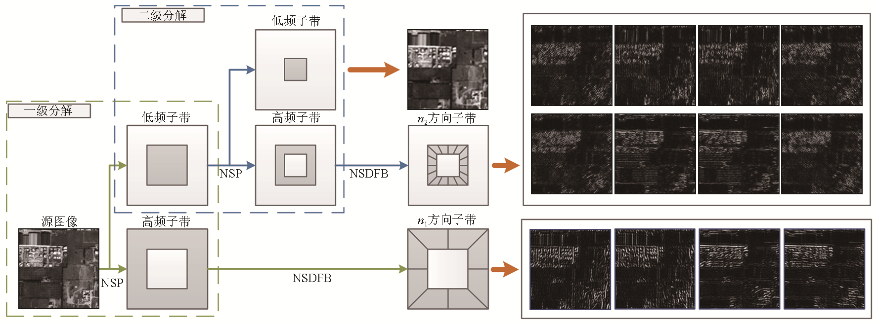
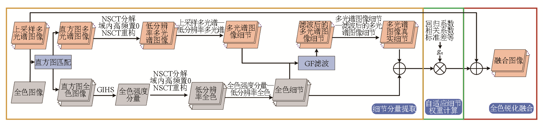
Abstract Remote sensing image fusion technology can combine and enhance information from two or more multi-source remote sensing images, making the fused image more accurate and comprehensive. The nonsubsampled contourlet transform (NSCT) is effective in extracting details from high-resolution remote sensing images through multi-scale and multi-directional decomposition, thus achieving image sharpening with high spatial resolution. However, traditional NSCT produces limited high-frequency details and is prone to introduce artifacts such as “ghosting” in fused images. To address this issue, the study proposed a new panchromatic sharpening fusion algorithm for remote sensing images by combining NSCT with a guided filter (GF). Specifically, the promoted algorithm extracted the detail components from histogram-matched images using the multi-scale, multi-direction decomposition and reconstruction properties of the NSCT. Meanwhile, it extracted multi-spectral detail components with panchromatic detail features using GF. Finally, the fused images with high-spatial and high-spectral resolutions were obtained by sharpening based on weighted detail components. The proposed algorithm was proved effective through both subjective and objective evaluations using multiple high-resolution remote sensing datasets.
|
| Keywords
nonsubsampled contourlet transform
guided filter
remote sensing image fusion
panchromatic sharpening
|
|
|
|
Issue Date: 17 February 2025
|
|
|
| [1] |
Hu J, Hu P, Wang Z, et al. Spatial dynamic selection network for remote-sensing image fusion[J]. IEEE Geoscience and Remote Sensing Letters, 2021,19:8013205.
|
| [2] |
Cao S Y, Hu X J. Dynamic prediction of urban landscape pattern based on remote sensing image fusion[J]. International Journal of Environmental Technology and Management, 2021, 24(1/2):18.
|
| [3] |
Xu J, Luo C, Chen X, et al. Remote sensing change detection based on multidirectional adaptive feature fusion and perceptual similarity[J]. Remote Sensing, 2021, 13(15):3053.
|
| [4] |
Li H, Song D, Liu Y, et al. Automatic pavement crack detection by multi-scale image fusion[J]. IEEE Transactions on Intelligent Transportation Systems, 2019, 20(6):2025-2036.
|
| [5] |
盖钧飞, 李小军, 赵鹤婷, 等. 结合脉冲耦合神经网络的自适应全色锐化算法[J]. 测绘科学, 2023, 48(1):60-69.
|
| [5] |
Ge J F, Li X J, Zhao H T, et al. Adaptive panchromatic sharpening algorithm with pulse coupled neural network[J]. Science of Surveying and Mapping, 2023, 48(1):60-69.
|
| [6] |
Wady S M A, Bentoutou Y, Bengermikh A, et al. A new IHS and wavelet based pansharpening algorithm for high spatial resolution satellite imagery[J]. Advances in Space Research, 2020, 66(7):1507-1521.
|
| [7] |
Dadrass Javan F, Samadzadegan F, Mehravar S, et al. A review of image fusion techniques for pan-sharpening of high-resolution satellite imagery[J]. ISPRS Journal of Photogrammetry and Remote Sensing, 2021,171:101-117.
|
| [8] |
Wu Z, Huang Y, Zhang K. Remote sensing image fusion method based on PCA and curvelet transform[J]. Journal of the Indian Society of Remote Sensing, 2018, 46(5):687-695.
|
| [9] |
张涛, 刘军, 杨可明, 等. 结合Gram-Schmidt变换的高光谱影像谐波分析融合算法[J]. 测绘学报, 2015, 44(9):1042-1047.
doi: 10.11947/j.AGCS.2015.20140637
|
| [9] |
Zhang T, Liu J, Yang K M, et al. Fusion algorithm for hyperspectral remote sensing image combined with harmonic analysis and gram-schmidt transform[J]. Acta Geodaetica et Cartographica Sinica, 2015, 44(9):1042-1047.
doi: 10.11947/j.AGCS.2015.20140637
|
| [10] |
吴一全, 王志来. 混沌蜂群优化的NSST域多光谱与全色图像融合[J]. 遥感学报, 2017, 21(4):549-557.
|
| [10] |
Wu Y Q, Wang Z L. Multispectral and panchromatic image fusion using chaotic Bee Colony optimization in NSST domain[J]. Journal of Remote Sensing, 2017, 21(4):549-557.
|
| [11] |
Jin H, Wang Y. A fusion method for visible and infrared images based on contrast pyramid with teaching learning based optimization[J]. Infrared Physics & Technology, 2014,64:134-142.
|
| [12] |
Do M N, Vetterli M. The contourlet transform:An efficient directional multiresolution image representation[J]. IEEE Transactions on Image Processing:A Publication of the IEEE Signal Processing Society, 2005, 14(12):2091-2106.
|
| [13] |
Lim W Q. The discrete shearlet transform:A new directional transform and compactly supported shearlet frames[J]. IEEE Transactions on Image Processing:a Publication of the IEEE Signal Processing Society, 2010, 19(5):1166-1180.
|
| [14] |
Singh H, Cristobal G, Blanco S, et al. Nonsubsampled contourlet transform based tone-mapping operator to optimize the dynamic range of diatom shells[J]. Microscopy Research and Technique, 2021, 84(9):2034-2045.
|
| [15] |
徐欣钰, 李小军, 赵鹤婷, 等. NSCT和PCNN相结合的遥感图像全色锐化算法[J/OL]. 自然资源遥感,[2023-09-18].http://kns.cnki.net/kcms/detail/10.1759.P.20221102.1831.020.html.
url: http://kns.cnki.net/kcms/detail/10.1759.P.20221102.1831.020.html
|
| [15] |
Xu X Y, Li X J, Zhao H T, et al. Pansharpening algorithm of remote sensing images based on by combining NSCT and PCNN[J]. Remote Sensing for Natural Resources.[2023-09-18].http://kns.cnki.net/kcms/detail/10.1759.P.20221102.1831.020.html.
url: http://kns.cnki.net/kcms/detail/10.1759.P.20221102.1831.020.html
|
| [16] |
Cunha A L, Zhou J, Do M N. The nonsubsampled contourlet transform:Theory,design,and applications[J]. IEEE Transactions on Image Processing:A Publication of the IEEE Signal Processing Society, 2006, 15(10):3089-3101.
|
| [17] |
He K, Sun J, Tang X. Single image haze removal using dark channel prior[J]. IEEE Transactions on Pattern Analysis and Machine Intelligence, 2011, 33(12):2341-2353.
doi: 10.1109/TPAMI.2010.168
pmid: 20820075
|
| [18] |
He K, Sun J, Tang X. Guided image filtering[J]. IEEE Transactions on Pattern Analysis and Machine Intelligence, 2013, 35(6):1397-1409.
doi: 10.1109/TPAMI.2012.213
pmid: 23599054
|
| [19] |
Choi J, Yu K, Kim Y. A new adaptive component-substitution-based satellite image fusion by using partial replacement[J]. IEEE Transactions on Geoscience and Remote Sensing, 2011, 49(1):295-309.
|
| [20] |
张立福, 彭明媛, 孙雪剑, 等. 遥感数据融合研究进展与文献定量分析(1992-2018)[J]. 遥感学报, 2019, 23(4):603-619.
|
| [20] |
Zhang L F, Peng M Y, Sun X J, et al. Progress and bibliometric analysis of remote sensing data fusion methods(1992-2018)[J]. Journal of Remote Sensing, 2019, 23(4):603-619.
|
| [21] |
Wald L, Ranchin T, Mangolini M. Fusion of satellite images of different spatial resolutions:Assessing the quality of resulting images[J]. Photogrammetric Engineering and Remote Sensing, 1997, 63(6):691-699.
|
| [22] |
Aiazzi B, Baronti S, Selva M. Improving component substitution pansharpening through multivariate regression of MS+Pan data[J]. IEEE Transactions on Geoscience and Remote Sensing, 2007, 45(10):3230-3239.
|
| [23] |
Vivone G, Dalla Mura M, Garzelli A, et al. A new benchmark based on recent advances in multispectral pansharpening:Revisiting pansharpening with classical and emerging pansharpening methods[J]. IEEE Geoscience and Remote Sensing Magazine, 2021, 9(1):53-81.
|
| [24] |
Vivone G, Alparone L, Chanussot J, et al. A critical comparison among pansharpening algorithms[J]. IEEE Transactions on Geoscience and Remote Sensing, 2015, 53(5):2565-2586.
|
|
Viewed |
|
|
|
Full text
|
|
|
|
|
Abstract
|
|
|
|
|
Cited |
|
|
|
|
| |
Shared |
|
|
|
|
| |
Discussed |
|
|
|
|
 2025,
Vol. 37
2025,
Vol. 37