

0 引言
HSI和LiDAR数据的融合研究主要集中在3个方面: ①如何生成有效的特征; ②如何确定有效的融合方法; ③如何借助机器学习进行分类。在特征生成方面,Pedergnana等[5]利用扩展属性剖面进行特征提取,将LiDAR数据分别与多光谱和高光谱影像融合,并应用于意大利特兰托的土地覆盖分类; Ni等[6]采用一种结合HSI与LiDAR数据的边缘约束马尔可夫随机场对城市地区土地覆盖进行分类,该方法具有边缘约束权重系数保护类边界和控制平滑度的优点。在特征融合方面,Zhang等[7]提出了基于最大分歧原则的集成多核主动学习框架和基于复合核的特征提取方法,对多源数据中的不同特征进行分类; Gu等[8]提出了一种新的集成多光谱影像和LiDAR数据的多核模型,把不同尺度上每个特征样本的相似性用线性组合集成,得到异构最佳组合内核; Liao等[9]提出了一种基于广义图的特征融合方法,融合图的边缘通过叠加特征点之间的距离定权,能更好地建立与连接点之间的实际相似性,有助于提高分类精度。在分类器设计方面,Bigdeli等[10]提出了能够克服维数困难的基于特征分组的融合高光谱和LiDAR数据的多模糊分类器系统,随后又提出了一个基于决策模板的模糊多分类器系统[11],用于高光谱和LiDAR数据的融合,实验发现对有更多复杂关系的混合信息来说,模糊分类结果比常规分类方法更令人满意,同时多分类器系统在融合领域比限制更多的单分类器表现出更好的性能; Castrodad等[12]提出了一种稀疏建模算法用于数据源的分离和分类,通过非监督算法学习字典,该方法还能有效减轻部分遮挡所造成的海拔差异和阴影影响; Zhang等[13]提出了一个自适应局部加权多源联合稀疏表示的分类模型,基于多任务联合稀疏表示的框架,解决了均匀权重和不稳定系数估计等问题。由此可见,HSI与LiDAR 融合与分类研究越来越丰富和成熟,并逐渐应用于各个领域,如树种识别[14]、景观视觉[15]和土地利用分类[16]等 。李光辉等[17]以西藏那曲县境内的“中习一号”冰川为研究区,发现融合机载LiDAR和HIS这2种数据的优势,能更方便地提取出冰川雪线,更好地显示雪线高度,从而应用于冰川融化灾害的应急反应监测。
本研究采用2012年获取的黑河中游张掖绿洲农业区CASI/SASI航空高光谱遥感影像和LiDAR数据作为研究数据源,采用多种方法对二者分别进行特征提取后进行融合分类,探索出分类精度最好的方法。
1 研究区与数据源
1.1 研究区概况
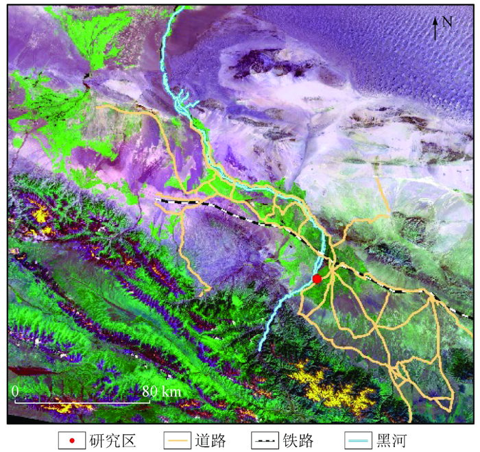
黑河流域发源于甘肃省南部的祁连山区,北至中蒙边境,东与石羊河流域相连,西与疏勒河流域毗邻[18]。黑河中游地处河西走廊平原,由多个规模不等的人工绿洲组成,自东向西依次为山丹绿洲、张掖绿洲和酒泉绿洲,都是重要的农业区。本文研究区黑河中游张掖绿洲农业区位于E100.1°~100.9°和N38.5°~39.4°之间(图1),农业资源丰富,盛产小麦、玉米、水稻、油菜和胡麻等多种农作物,是国家重要的商品粮基地,属于典型的农牧绿洲。区内的灌溉、垦殖和放牧使地面景观具有强烈的人为干扰特征,主要土地利用类型包括耕地、林地(乔木、灌木、疏林、园林等)、草地、水体、建设用地(城镇用地、农村居民点等)和未利用地(沙地、戈壁、裸岩石砾地、裸土、盐碱地等)[19]。
图1
1.2 数据源
高光谱遥感影像数据(以下简称“CASI/SASI数据”)由黑河计划数据管理中心(http: //westdc.westgis.ac.cn/hiwater)提供,获取于2012年6月9日,是“黑河生态水文遥感试验: 可见光近红外高光谱航空遥感”试验项目的重要产品[21]。该数据已经进行了几何定标、辐射定标和大气校正,CASI和SASI传感器的光谱范围分别为0.38~1.05 μm和0.95~2.45 μm,波段数目分别为48和101,空间分辨率分别为1.0 m和2.4 m。利用核心观测区122 642(CASI)和122 910(SASI)航带,经过裁剪获得研究区数据,CASI B40(R),B20(G),B10(B)假彩色合成影像如图2 (a)所示,其空间大小为667像素×417像素。图2 (b)为研究区地面参考数据。
图2
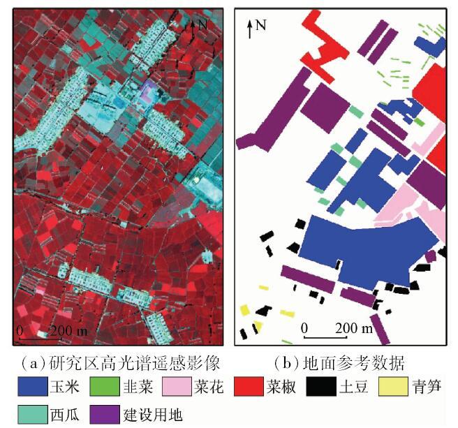
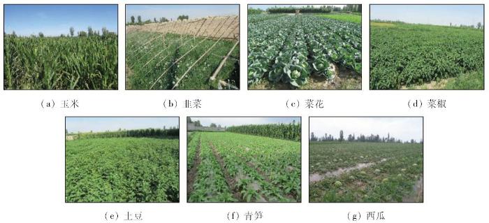
在研究区土地覆盖类型数据集的基础上通过人工选取得到了地面参考数据,主要包含玉米、韭菜、菜花、菜椒、土豆、青笋、西瓜和建设用地等8种地表覆盖类型。同步拍摄的地类实地照片如图3所示。对该数据分类的特点和难点在于精细的农作物区分和不均衡地类的区分。
图3
LiDAR数据也由黑河计划数据管理中心提供(图4)。
图4
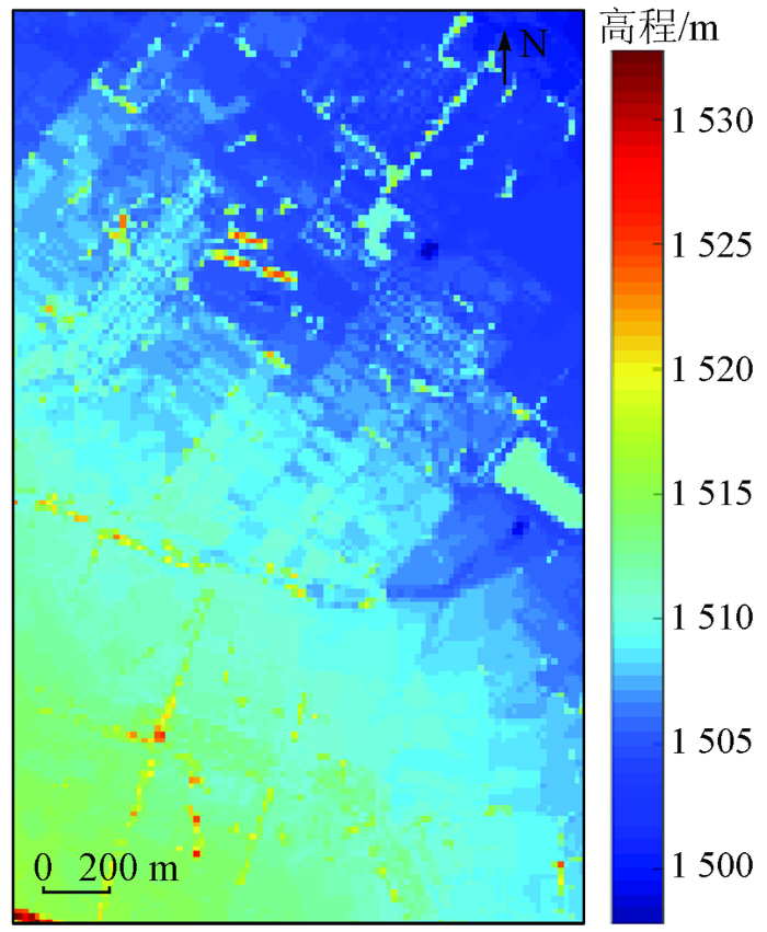
该数据获取于2012年7月19日,在黑河中游核心观测区域,先利用Leica公司ALS70的运12飞机开展LiDAR航空遥感飞行试验获取原始数据,再通过参数检校、点云自动分类和人工编辑等步骤,最终形成数字表面模型(digital surface model,DSM)数据产品。
2 原理与方法
本文提出的方法主要包括3个重要环节: ①对HSI进行光谱维特征提取; ②基于扩展多属性剖面(extended multi- attribute profile,EMAP)和基于扩展属性剖面(extended attribute profile,EAP)进行空间维特征提取; ③基于稀疏多项式逻辑回归分类器(sparse multinomial logistic regression,SMLR)的分类。将LiDAR生成的DSM和航拍HSI作为初始的实验影像,首先对HSI做主成分分析(principal component analysis,PCA),实现影像降维; 然后,采用EMAP/EAP对HSI和LiDAR数据进行空间维特征提取; 最后,将光谱信息、空间信息及高程信息进行融合。根据实地测量数据,选择训练样本,采用SMLR分类器分别对不同融合影像进行分类。选取总体精度(overall accuracy,OA)、平均精度(average accuracy,AA)、单个类的精度(class-specific accuracy,CA)和Kappa 系数评价分类结果。技术流程如图5所示。
图5
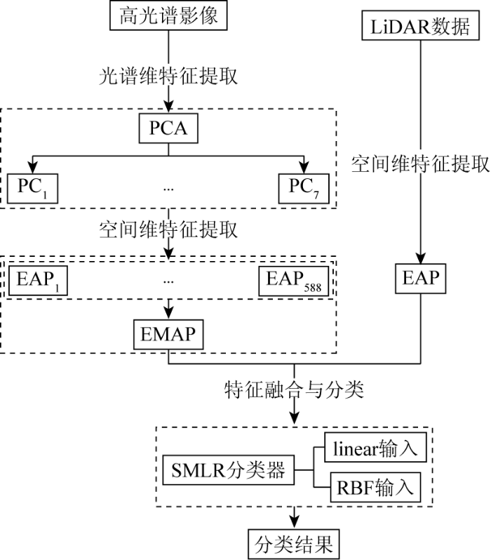
2.1 基于数学形态学的空间维特征提取
利用PCA对高光谱数据进行特征提取,保留信息量超过99.4%的前7个主分量。采用EMAP对降维后的HSI和LiDAR数据提取空间特征。利用面积(50, 50, …, 500),转动惯量(0.1, 0.1, …, 1),标准偏差(2.5, 2.5, …, 25),边界框的对角线长度(50, 50, …, 500)这4种属性,得到588维的EMAP。需特别指出的是,LiDAR数据因只包含一维的DSM高程信息,因此相应得到EAP特征。
2.2 多源特征融合与分类
利用简单的堆叠特征级融合,形成一个扩展的特征向量。特征级融合注重特征提取之后的融合,是将特征进行有意义的组合,从而获得对特征属性的判断具有更高的可信性和准确性[15]。采用SMLR分类器进行分类实验,按照分类器输入的不同,又分为线性分类器(linear)和径向基函数(radial basis function,RBF)-马尔可夫随机场(markov random field,MRF)分类器。linear形式为线性输入,即直接输入特征; RBF-MRF形式是先把特征用RBF映射到核空间进行分类,再用一种有效的图割(graph cuts)模型MRF进行分类后处理,以消除分类结果中的孤立点。在给定训练样本的条件下,对不同特征组合进行分类,对比各自的分类精度。
3 实验结果与分析
实验中,Xh为原始HSI特征、EMAP(Xh)为在HSI上提取的EMAP特征、EAP(XL)为在LiDAR DSM数据上获取的EAP特征。将这些特征组合,分别得到Xh+EMAP(Xh),Xh+EAP(XL),EAP(XL)+EMAP(Xh)和Xh+EAP(XL)+EMAP(Xh)这4种不同的组合。另外,设定训练样本为20个/类。
3.1 基于EMAP单一特征的分类
图6

图6
基于EMAP和EAP单一特征的分类结果
Fig.6
Classification results of a single feature based on EMAP and EAP
表1 基于2种形式的SMLR对不同单一特征EMAP和EAP分类的精度与Kappa系数
Tab.1
| 序号 | 类别 | linear | RBF-MRF | ||||
|---|---|---|---|---|---|---|---|
| Xh | EMAP(Xh) | EAP(XL) | Xh | EMAP(Xh) | EAP(XL) | ||
| 1 | 玉米 | 87.20 | 87.28 | 54.16 | 94.59 | 86.40 | 70.53 |
| 2 | 韭菜 | 88.92 | 92.13 | 65.51 | 96.54 | 98.10 | 87.96 |
| 3 | 菜花 | 84.78 | 93.10 | 79.33 | 85.29 | 94.47 | 91.35 |
| 4 | 菜椒 | 87.02 | 84.75 | 79.48 | 95.02 | 97.14 | 74.17 |
| 5 | 土豆 | 94.09 | 84.53 | 53.07 | 97.70 | 88.08 | 42.57 |
| 6 | 冬笋 | 96.93 | 95.86 | 90.75 | 98.47 | 98.98 | 83.14 |
| 7 | 西瓜 | 81.92 | 87.55 | 72.83 | 95.45 | 80.50 | 66.68 |
| 8 | 建设用地 | 77.47 | 75.42 | 31.26 | 97.87 | 97.53 | 53.85 |
| OA | 84.41 | 83.96 | 53.09 | 95.08 | 91.70 | 66.70 | |
| AA | 87.29 | 87.58 | 65.80 | 95.12 | 92.65 | 71.28 | |
| Kappa | 78.82 | 78.24 | 41.45 | 93.10 | 88.59 | 56.37 | |
也是非常重要的。因此,如果可以同时考虑多特征,可能会在较大程度上提高分类的准确性。
3.2 基于EMAP融合特征的分类
图7
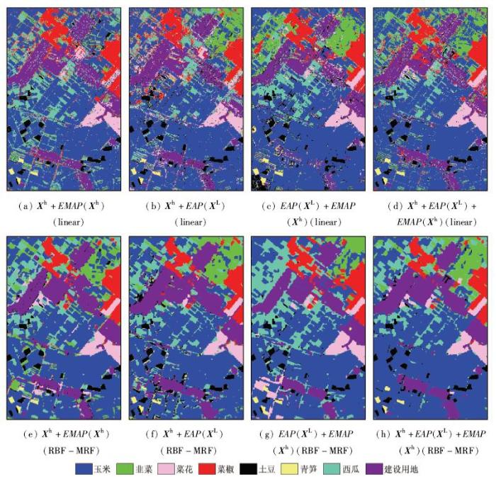
图7
基于EMAP和EAP的多源特征组合的分类结果
Fig.7
Classification results of multi features combination based on EMAP and EAP
表2 基于2种形式的SMLR对多源特征组合(EMAP和EAP)分类的精度与Kappa系数
Tab.2
| 序号 | 类别 | linear | RBF-MRF | ||||||
|---|---|---|---|---|---|---|---|---|---|
| Xh+ EMAP(Xh) | Xh+ EAP(XL) | EAP(XL)+ EMAP(Xh) | Xh+EAP(XL)+ EMAP(Xh) | Xh+ EMAP(Xh) | Xh+ EAP(XL) | EAP(XL)+ EMAP(Xh) | Xh+EAP(XL)+ EMAP(Xh) | ||
| 1 | 玉米 | 91.71 | 89.31 | 87.97 | 90.91 | 91.79 | 90.31 | 90.99 | 91.27 |
| 2 | 韭菜 | 95.21 | 92.26 | 91.37 | 94.69 | 96.54 | 91.64 | 86.96 | 92.42 |
| 3 | 菜花 | 90.00 | 87.39 | 94.99 | 94.85 | 94.86 | 91.59 | 95.45 | 93.82 |
| 4 | 菜椒 | 93.36 | 89.64 | 89.32 | 93.20 | 96.17 | 92.59 | 96.64 | 94.76 |
| 5 | 土豆 | 95.43 | 95.21 | 87.09 | 93.94 | 96.89 | 94.92 | 95.38 | 97.56 |
| 6 | 冬笋 | 98.31 | 98.49 | 95.25 | 98.29 | 97.83 | 98.98 | 98.98 | 99.11 |
| 7 | 西瓜 | 86.05 | 93.51 | 94.64 | 92.22 | 97.08 | 92.18 | 95.40 | 97.38 |
| 8 | 建设用地 | 86.49 | 82.81 | 78.16 | 83.40 | 97.19 | 98.31 | 96.31 | 98.68 |
| OA | 90.36 | 87.72 | 85.98 | 89.53 | 94.53 | 93.33 | 93.85 | 94.50 | |
| AA | 92.07 | 91.08 | 89.85 | 92.69 | 96.04 | 93.81 | 94.51 | 95.62 | |
| Kappa | 86.65 | 83.17 | 80.80 | 85.58 | 92.39 | 90.72 | 91.45 | 92.35 | |
3.3 泛化性分析
进一步就每类训练样本的个数与多源特征组合的分类结果精度关系展开实验。不同形式的特征组合分类结果如图8所示。
图8
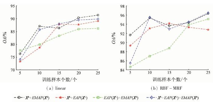
图8
基于SMLR不同形式的特征组合分类结果与训练样本个数的关系
Fig.8
Relationship between the two types of feature combination’s classification results and the number of training samples based on SMLR
从图8中可以发现,不论是基于实验中的哪种特征组合及分类器,在一定范围内,训练样本个数的增加,分类结果的总体精度均呈波动上升趋势。但由于特征组合的不同和分类器的不同,增加的幅度各有不同。
4 结论
本文提出了一种高光谱和激光雷达数据融合和分类的有效策略。主要结论如下:
1)该方法有效地集成了多种类型的特征提取,使不同的类型特征可以有效地被集成利用。研究中考虑了几种类型来自原始高光谱影像的光谱空间特征和LiDAR的DSM,包括了完整的原始光谱信息、不同类型的基于EMAP的高光谱特征和基于EAP的LiDAR特征。实验结果表明LiDAR信息确实能起到有效补充的作用,提高分类精度。
2)研究发现Xh+EMAP(Xh)组合得到了最高的分类精度,而Xh+EAP(XL)+EMAP(Xh)组合同样也得到了很好的分类精度,并能随着训练样本个数的增加,可以更有效地提高分类精度。
下一步将继续围绕高光谱与LiDAR数据融合分类进行研究,注意将流形学习方法引入到光谱维特征提取,将集成学习方法引入对二者融合特征的分类中,进一步研究提高分类精度的有效框架。
参考文献
高光谱图像分类方法研究
[D].
On Classification Method of Hyperspectral Images
[D].
基于机载LiDAR和高光谱融合的森林参数反演研究
[D].
Fused Airborne LiDAR and Hyperspectral Data for Tree Species Identification in a Natural Temperate Forest
[D].
Classification of remote sensing optical and LiDAR data using extended attribute profiles
[J].
DOI:10.1109/JSTSP.2012.2208177
URL
[本文引用: 1]

Extended Attribute Profiles (EAPs), which are obtained by applying morphological attribute filters to an image in a multilevel architecture, can be used for the characterization of the spatial characteristics of objects in a scene. EAPs have proved to be discriminant features when considered for thematic classification in remote sensing applications especially when dealing with very high resolution images. Altimeter data (such as LiDAR) can provide important information, which being complementary to the spectral one can be valuable for a better characterization of the surveyed scene. In this paper, we propose a technique performing a classification of the features extracted with EAPs computed on both optical and LiDAR images, leading to a fusion of the spectral, spatial and elevation data. The experiments were carried out on LiDAR data along either with a hyperspectral and a multispectral image acquired on a rural and urban area of the city of Trento (Italy), respectively. The classification accuracies obtained pointed out the effectiveness of the features extracted by EAPs on both optical and LiDAR data for classification.
Edge-constrained Markov random field classification by integrating hyperspectral image with LiDAR data overurban areas
[J].
DOI:10.1117/1.JRS.8.085089
URL
[本文引用: 1]
This paper proposes an edge-constrained Markov random field (EC-MRF) method for accurate land cover classification over urban areas using hyperspectral image and LiDAR data. EC-MRF adopts a probabilistic support vector machine for pixel-wise classification of hyperspectral and LiDAR data, while MRF performs as a postprocessing regularizer for spatial smoothness. LiDAR data improve both pixel-wise classification and postprocessing result during an EC-MRF procedure. A variable weighting coefficient, constrained by a combined edge extracted from both hyperspectral and LiDAR data, is introduced for the MRF regularizer to avoid oversmoothness and to preserve class boundaries. The EC-MRF approach is evaluated using synthetic and real data, and results indicate that it is more effective than four similar advanced methods for the classification of hyperspectral and LiDAR data.
Ensemble multiple kernel active learning for classification of multisource remote sensing data
[J].
DOI:10.1109/JSTARS.2014.2359136
URL
[本文引用: 1]
Incorporating disparate features from multiple sources can provide valuable diverse information for remote sensing data analysis. However, multisource remote sensing data require large quantities of labeled data to train robust supervised classifiers, which are often difficult and expensive to acquire. A mixture-of-kernel approach can facilitate the construction of an effective formulation for acquiring useful samples via active learning (AL). In this paper, we propose an ensemble multiple kernel active learning (EnsembleMKL-AL) framework that incorporates different types of features extracted from multisensor remote sensing data (hyperspectral imagery and LiDAR data) for robust classification. An ensemble of probabilistic multiple kernel classifiers is embedded into a maximum disagreement-based AL system, which adaptively optimizes the kernel for each source during the AL process. At the end of each learning step, a decision fusion strategy is implemented to make a final decision based on the probabilistic outputs. The proposed framework is tested in a multisource environment, including different types of features extracted from hyperspectral and LiDAR data. The experimental results validate the efficacy of the proposed approach. In addition, we demonstrate that using ensemble classifiers and a large number of disparate but relevant features can further improve the performance of an AL-based classification approach.
A novel MKL model of integrating LiDAR data and MSI for urban area classification
[J].
DOI:10.1109/TGRS.2015.2421051
URL
[本文引用: 1]
A novel multiple-kernel learning (MKL) model is proposed for urban classification to integrate heterogeneous features (HF-MKL) from two data sources, i.e., spectral images and LiDAR data. The features include spectral, spatial, and elevation attributes of urban objects from the two data sources. With these heterogeneous features (HFs), the new MKL model is designed to carry out feature fusion that is embedded in classification. First, Gaussian kernels with different bandwidths are used to measure the similarity of samples on each feature at different scales. Then, these multiscale kernels with different features are integrated using a linear combination. In the combination, the weights of the kernels with different features are determined by finding a projection based on the maximum variance. This way, the discriminative ability of the HFs is exploited at different scales and is also integrated to generate an optimal combined kernel. Finally, the optimization of the conventional support vector machine with this kernel is performed to construct a more effective classifier. Experiments are conducted on two real data sets, and the experimental results show that the HF-MKL model achieves the best performance in terms of classification accuracies in integrating the HFs for classification when compared with several state-of-the-art algorithms.
Generalized graph-based fusion of hyperspectral and LiDAR data using morphological features
[J].
DOI:10.1109/LGRS.2014.2350263
URL
[本文引用: 1]
Nowadays, we have diverse sensor technologies and image processing algorithms that allow one to measure different aspects of objects on the Earth [e.g., spectral characteristics in hyperspectral images (HSIs), height in light detection and ranging (LiDAR) data, and geometry in image processing technologies, such as morphological profiles (MPs)]. It is clear that no single technology can be sufficient for a reliable classification, but combining many of them can lead to problems such as the curse of dimensionality, excessive computation time, and so on. Applying feature reduction techniques on all the features together is not good either, because it does not take into account the differences in structure of the feature spaces. Decision fusion, on the other hand, has difficulties with modeling correlations between the different data sources. In this letter, we propose a generalized graph-based fusion method to couple dimension reduction and feature fusion of the spectral information (of the original HSI) and MPs (built on both HS and LiDAR data). In the proposed method, the edges of the fusion graph are weighted by the distance between the stacked feature points. This yields a clear improvement over an older approach with binary edges in the fusion graph. Experimental results on real HSI and LiDAR data demonstrate effectiveness of the proposed method both visually and quantitatively.
Feature grouping-based multiple fuzzy classifier system for fusion of hyperspectral and LiDAR data
[J].
DOI:10.1117/1.JRS.8.083509
URL
[本文引用: 1]
Interest in the joint use of different data from multiple sensors has been increased for classification applications. This is because the fusion of different information can produce a better understanding of the observed site. In this field of study, the fusion of light detection and ranging (LIDAR) and passive optical remote sensing data for classification of land cover has attracted much attention. This paper addressed the use of a combination of hyperspectral (HS) and LIDAR data for land cover classification. HS images provide a detailed description of the spectral signatures of classes, whereas LIDAR data give detailed information about the height but no information for the spectral signatures. This paper presents a multiple fuzzy classifier system for fusion of HS and LIDAR data. The system is based on the fuzzy K-nearest neighbor (KNN) classification of two data sets after application of feature grouping on them. Then a fuzzy decision fusion method is applied to fuse the results of fuzzy KNN classifiers. An experiment was carried out on the classification of HS and LIDAR data from Houston, USA. The proposed fuzzy classifier ensemble system for HS and LIDAR data provide interesting conclusions on the effectiveness and potentials of the joint use of these two data. Fuzzy classifier fusion on these two data sets improves the classification results when compared with independent single fuzzy classifiers on each data set. The fuzzy proposed method represented the best accuracy with a gain in overall accuracy of 93%.
Fusion of hyperspectral and LiDAR data using decision template-based fuzzy multiple classifier system
[J].
DOI:10.1016/j.jag.2015.01.017
URL
[本文引用: 1]
Regarding to the limitations and benefits of remote sensing sensors, fusion of remote sensing data from multiple sensors such as hyperspectral and LIDAR (light detection and ranging) is effective at land cover classification. Hyperspectral images (HSI) provide a detailed description of the spectral signatures of classes, whereas LIDAR data give height detailed information. However, because of the more complexities and mixed information in LIDAR and HSI, traditional crisp classification methods could not be more efficient. In this situation, fuzzy classifiers could deliver more satisfactory results than crisp classification approaches. Also, referring to the limitation of single classifiers, multiple classifier system (MCS) may exhibit better performance in the field of multi-sensor fusion. This paper presents a fuzzy multiple classifier system for fusions of HSI and LIDAR data based on decision template (DT). After feature extraction and feature selection on each data, all selected features of both data are applied on a cube. Then classifications were performed by fuzzy k-nearest neighbour (FKNN) and fuzzy maximum likelihood (FML) on cube of features. Finally, a fuzzy decision fusion method is utilized to fuse the results of fuzzy classifiers. In order to assess fuzzy MCS proposed method, a crisp MCS based on support vector machine (SVM), KNN and maximum likelihood (ML) as crisp classifiers and naive Bayes (NB) as crisp classifier fusion method is applied on selected cube feature. A co-registered HSI and LIDAR data set from Houston of USA was available to examine the effect of proposed MCSs. Fuzzy MCS on HSI and LIDAR data provide interesting conclusions on the effectiveness and potentialities of the joint use of these two data.
Sparse modeling for hyperspectral imagery with LiDAR data fusion for subpixel mapping
[J].
DOI:10.1109/IGARSS.2012.6351982
URL
[本文引用: 1]
Several studies suggest that the use of geometric features along with spectral information improves the classification and visualization quality of hyperspectral imagery. These studies normally make use of spatial neighborhoods of hyperspectral pixels for extracting these geometric features. In this work, we merge point cloud Light Detection and Ranging (LiDAR) data and hyperspectral imagery (HSI) into a single sparse modeling pipeline for subpixel mapping and classification. The model accounts for material variability and noise by using learned dictionaries that act as spectral endmembers. Additionally, the estimated abundances are influenced by the LiDAR point cloud density, particularly helpful in spectral mixtures involving partial occlusions and illumination changes caused by elevation differences. We demonstrate the advantages of the proposed algorithm with co-registered LiDAR-HSI data.
Multisource geospatial data fusion via local joint sparse representation
[J].
DOI:10.1109/TGRS.2016.2514481
URL
[本文引用: 1]
In this paper, we propose an adaptive locality weighted multisource joint sparse representation classification (ALWMJ-SRC) model for the classification of multisource remote sensing data. Although the notion of multitask joint sparsity has been recently developed for data fusion and has shown to be effective for various applications, in this paper, we suggest that there are important limitations stemming from the assumptions in such a framework. We propose a formulation that is inspired by this approach yet addresses some of the key shortcomings (e.g., uniform weights and unstable estimation of coefficients), resulting in a more robust formulation for data fusion. Specifically, we impose an adaptive locality weight to constrain the sparse coefficients, which not only considers the locality information between the test sample and the atoms in the dictionary but also helps ensure that the coefficients are adaptively penalized, reducing estimation bias. The adaptive locality weight is calculated for each source, which ensures that complementary information is employed from different sources for fusion. The optimization problem is solved using an alternating-direction-methods-of-multipliers formulation. In addition, the proposed algorithm is extended to the kernel space. The efficacy of the proposed algorithm is validated via experiments for two fusion scenarios-spectral-spatial classification and hyperspectral-LiDAR sensor fusion. The experimental results demonstrate that ALWMJ-SRC consistently performs better than state-of-the-art classification approaches.
Fusion of hyperspectral and LiDAR data for landscape visual quality assessment
[J].
DOI:10.1109/JSTARS.2014.2313356
URL
[本文引用: 1]
Landscape visual quality is an important factor associated with daily experiences and influences our quality of life. In this work, the authors present a method of fusing airborne hyperspectral and mapping light detection and ranging (LiDAR) data for landscape visual quality assessment. From the fused hyperspectral and LiDAR data, classification and depth images at any location can be obtained, enabling physical features such as land-cover properties and openness to be quantified. The relationship between physical features and human landscape preferences is learned using least absolute shrinkage and selection operator (LASSO) regression. The proposed method is applied to the hyperspectral and LiDAR datasets provided for the 2013 IEEE GRSS Data Fusion Contest. The results showed that the proposed method successfully learned a human perception model that enables the prediction of landscape visual quality at any viewpoint for a given demographic used for training. This work is expected to contribute to automatic landscape assessment and optimal spatial planning using remote sensing data.
激光雷达和高光谱数据融合的城市土地利用分类方法研究
[D].
Fusion of Hyperspectral and LiDAR Data for Urban Land Use Classification
[D].
高光谱遥感影像与机载LiDAR数据融合的地物提取方法研究
[J].
DOI:10.3969/j.issn.1000-3177.2014.06.015
URL
[本文引用: 1]
本文利用高光谱遥感影像和机载 LiDAR 数据融合来重点提取城市的房屋和树木目标。首先通过机载LiDAR 点云数据提取数字地面模型(Digital Surface Model,DSM)和数字地形模型(Digital Terrain Model,DTM),进一步差值计算得到 nDSM (normalized Digital Surface Model)。利用高光谱影像计算归一化植被指数(Normalized Difference Vegetation Index,NDVI),采用主成分分析法(Principal Component Analysis,PCA)进行去噪和降维处理。结合 nDSM 和 NDVI 图像,采用面向对象的特征提取方法实现研究区内大型商用房屋的提取。对 PCA 图像和 nDSM 图像进行融合,然后采用最大似然分类(Maximum Likelihood Classification,MLC)方法进行监督分类,实现民用房屋和树木的提取。本文研究结果显示:商用房屋的正确提取率达到89.53%;MLC 方法对融合图像分类的总体精度为84.00%,Kappa 系数为82.86。
Feature extraction based on fusion of hyperspectral image and airborne LiDAR data
[J].
机载LiDAR和高光谱数据融合提取冰川雪线
[J].
Extraction of glacier snowline based on airborne LiDAR and hyperspectral data fusion
[J].
黑河流域生态—水文过程综合遥感观测联合试验总体设计
[J].
DOI:10.11867/j.issn.1001-8166.2012.05.0481
URL
[本文引用: 1]
介绍了"黑河流域生态—水文过程综合遥感观测联合试验"的背景、科学目标、试验组成和试验方案。试验的总体目标是显著提升对流域生态和水文过程的观测能力,建立国际领先的流域观测系统,提高遥感在流域生态—水文集成研究和水资源管理中的应用能力。由基础试验、专题试验、应用试验、产品与方法研究和信息系统组成。其中,①基础试验:搭载微波辐射计、成像光谱仪、热像仪、激光雷达等航空遥感设备,开展一系列关键生态和水文参量的观测;发展遥感正向模型及反演和估算方法。形成覆盖全流域的水文气象综合观测网,为流域生态—水文模型研究提供更有代表性的模型参数、驱动数据及更高精度的验证数据。构建无线传感器网络,度量生态水文模型所需的若干关键的驱动、参数和模型状态的空间异质性。开展航空遥感定标和地基遥感试验。依托传感器网络,并辅之以地面同步和加密观测,开展遥感产品真实性检验。②专题试验:开展"非均匀下垫面多尺度地表蒸散发观测试验",采用密集的涡动相关仪、大孔径闪烁仪与自动气象站的观测矩阵,为揭示地表蒸散发的空间异质性,实现非均匀下垫面地表蒸散发的尺度扩展,发展和验证蒸散发模型提供基础数据。③应用试验:在流域上、中、下游分别开展针对积雪和冻土水文、灌溉水平衡和作物生长、生态耗水的综合观测试验,将观测数据和遥感产品用于上游分布式水文模型、中游地表水—地下水—农作物生长耦合模型、下游生态耗水模型,通过实证研究提升遥感在流域生态—水文集成研究和水资源管理中的应用能力。加强试验将在2012年5月起按中游、上游、下游的顺序展开,全流域持续观测期为2013—2015年。在各类试验的支持下,开展全流域生态—水文关键参量遥感产品生产,发展尺度转换方法,建立多源遥感数据同化系统。
HiWATER:An integrated remote sensing experiment on hydrological and ecological processes in the Heihe River Basin
[J].
黑河流域中游张掖绿洲景观格局研究
[J].
DOI:10.3969/j.issn.1000-0240.2003.01.015
URL
[本文引用: 1]
In this paper, Zhangye Oasis, a famous agricultural base located in the alluvion of Heihe River in Northwest China is selected as study area. Landscape maps are compiled based on the landuse maps interpreted from Landsat TM images in 1995. Various landscape metrics are calculated by using the landscape structure analysis software-FRAGSTATS Version 3 at class and landscape levels, including total area of landscape, percentage of landscape types, patch density, edge density, largest patch indices, perimeter-area fractal dimension, interspersion & juxtaposition index, aggregation index, percentage of like adjacencies, patch cohesion index, Shannon diversity index, Shannon evenness index, patch richness and contagion. The results indicate that: desert, grassland, field and gobi are the major components in the oasis. The landscape patterns of the oasis are heterogeneous mosaics embedded in desert and gobi landscape matrix. Patches number of rural villages is the largest, which indicates the important influence of human beings. They are scattered in the whole landscapes and the cohesion indices is the lowest, because they are unconnected each other. The shape of bare rock and grassland are the most complex, which reflected the human-induced fragmentation of these types. In addition, the better connection of dry field, Gobi and bare rock indicate that the energy and mass can be transferred within the same types easily. At last, the caution of scale dependent of grid and classification was discussed.
Research on the landscape pattern of Zhangye Oasis in the middle reaches of Heihe River
[J].
高光谱遥感影像稀疏图嵌入分类研究
[D].
Hyperspectral Remote Sensing Image Classification via Sparse Graph Embedding
[D].
基于CASI影像的黑河中游种植结构精细分类研究
[J].
Fine classification of planting structure in the middle reaches of Heihe River Basin based on hyperspectral compace airborne spectrographic imager(CASI) data
[J].
高光谱遥感影像分类研究进展
[J].随着模式识别、机器学习、遥感技术等相关学科领域的发展,高光谱遥感影像分类研究取得快速进展。本文系统总结和评述了当前高光谱遥感影像分类的相关研究进展,在总结分类策略的基础上,重点从以核方法为代表的新型分类器设计、特征挖掘、空间-光谱分类、基于主动学习和半监督学习的分类、基于稀疏表达的分类、多分类器集成六个方面对高光谱影像像素级分类最新研究进行了综述。针对今后的研究方向,指出高光谱遥感影像分类一方面要适应大数据、智能化高光谱对地观测的发展前沿,继续引入机器学习领域的新理论、新方法,综合利用多源遥感数据、多维特征空间互补的优势,提高分类精度、分类器泛化能力和自动化程度;另一方面要关注高光谱遥感应用的需求,突出高光谱遥感记录精细光谱特征的优势,针对应用需求发展有效的分类方法。
Review of hyperspectral remote sensing image classification
[J].
基于CASI数据的黑河绿洲区叶面积指数反演
[J].
Inversion of leaf area index in Heihe Oasis based on CASI data
[J].
