Please wait a minute...
 
国土资源遥感  2018, Vol. 30 Issue (2): 93-99    DOI: 10.6046/gtzyyg.2018.02.13
     技术方法 本期目录 | 过刊浏览 | 高级检索 |
基于多特征融合的遥感影像变化检测算法
王光辉1(), 李建磊2, 王华斌1, 杨化超2
1.国家测绘地理信息局卫星测绘应用中心,北京 100830
2.中国矿业大学(徐州),徐州 221116
Change detection based on adaptive fusion of multiple features
Guanghui WANG1(), Jianlei LI2, Huabin WANG1, Huachao YANG2
1. Satelite Surveying and Mapping Application,NASG,Beijing 100830,China
2. China University of Mining and Technology(Xuzhou), Xuzhou 221116, China
全文: PDF(3089 KB)   HTML  
输出: BibTeX | EndNote (RIS)      
摘要 

针对传统的变化检测算法主要依赖像斑的光谱信息,未能有效地利用影像多特征检测优势的问题,基于面向对象的分析思想,提出一种多特征融合的遥感影像变化检测算法。首先,以多尺度分割的影像对象为基础,统计各对象的颜色直方图和边缘直线梯度直方图; 然后,利用推土机距离计算不同时期对象之间的颜色距离和边缘直线特征距离,采用自适应加权方法将颜色距离和边缘直线特征距离组合构建对象的异质性; 最后,采用直方图曲率分析获得像斑的变化检测结果。实验结果表明,该方法能够充分融合颜色和边缘直线特征,提高变化检测的精度。

服务
把本文推荐给朋友
加入引用管理器
E-mail Alert
RSS
作者相关文章
王光辉
李建磊
王华斌
杨化超
关键词 变化检测颜色直方图直线梯度直方图直方图距离直方图曲率    
Abstract

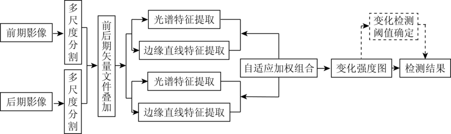
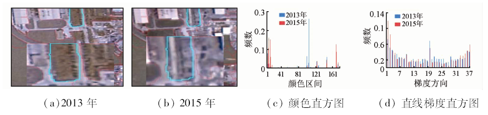
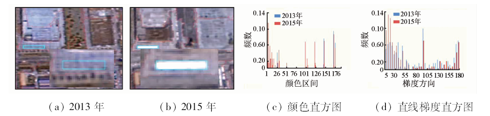
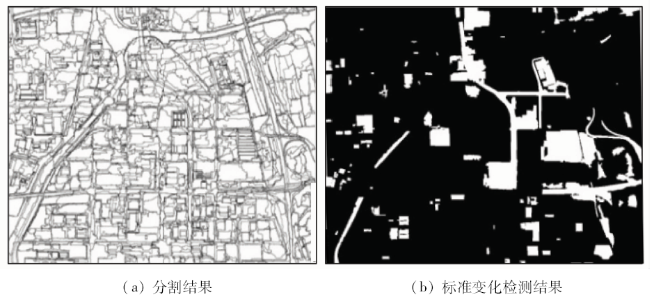
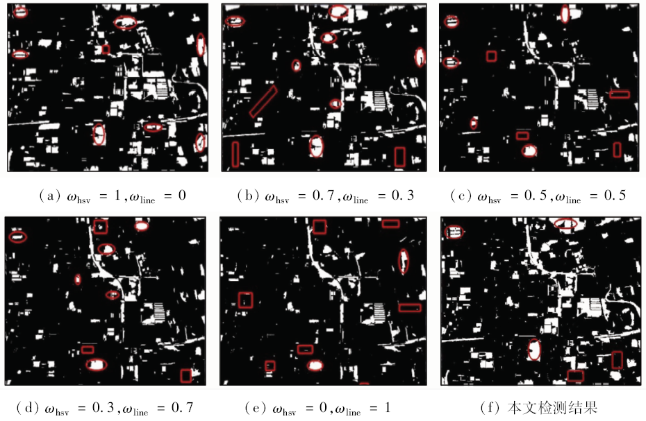
In view of the fact that the traditional change detection algorithm mainly depends on the spectral information and fails to effectively use image feature detection advantage, the authors put forward a multi-feature fusion of remote sensing image change detection algorithm. First, color histogram and edge histogram of gradient image object with multi-scale segmentation is statistically analyzed based on the calculation of each object. Then, the object color distance and edge linear characteristics distance between different periods are calculated by using the earth mover’s distance method; the adaptive weighted method is used to combine color distance and edge linear characteristics distance so as to construct object heterogeneity. Finally, the images change detection results are analyzed by using histogram curvature. The experimental results show that the method can fully fuse the color and edge line features and improve the accuracy of detection.

Key wordschange detection    color histogram    linear gradient histogram    histogram distance    histogram curvature
收稿日期: 2016-10-08      出版日期: 2018-05-30
:  TP79  
基金资助:高分辨率对地观测系统重大专项项目“高分遥感测绘应用示范系统(一期)”(编号: AH1601)
引用本文:   
王光辉, 李建磊, 王华斌, 杨化超. 基于多特征融合的遥感影像变化检测算法[J]. 国土资源遥感, 2018, 30(2): 93-99.
Guanghui WANG, Jianlei LI, Huabin WANG, Huachao YANG. Change detection based on adaptive fusion of multiple features. Remote Sensing for Land & Resources, 2018, 30(2): 93-99.
链接本文:  
https://www.gtzyyg.com/CN/10.6046/gtzyyg.2018.02.13      或      https://www.gtzyyg.com/CN/Y2018/V30/I2/93
Fig.1  变化检测流程
Fig.2  颜色主导区域
Fig.3  边缘直线主导区域
Fig.4  苏州市某城区影像
Fig.5  分割结果及标准检测结果
Fig.6  不同权重变化检测结果
参数 ωhsv=1 ωline=0 ωhsv=0.7 ωline=0.3 ωhsv=0.5 ωline=0.5
变化 未变化 变化 未变化 变化 未变化
实际变化/m2 684 947.40 781 227.60 926 630.50 575 792.40 814 214.35 739 430.11
实际未变化/m2 319 829.90 9 790 902.40 391 942.40 9 682 541.80 393 480.80 9 629 782.05
合计/m2 1 004 777.30 10 572 130.00 1 318 572.90 10 258 334.20 1 207 695.15 10 369 212.16
虚检率 0.32 0.30 0.33
漏检率 0.53 0.38 0.46
正确率 0.90 0.92 0.90
参数 ωhsv=0.3 ωline=0.7 ωhsv=0 ωline=1 本文算法
变化 未变化 变化 未变化 变化 未变化
实际变化/m2 1 090 209.13 348 681.20 1 288 899.00 177 276.00 1 174 865.98 327 581.02
实际未变化/m2 583 248.27 9 554 768.70 867 573.00 9 243 159.20 374 527.02 9 699 933.08
合计/m2 1 673 457.40 9 903 449.90 2 156 472.00 9 420 435.20 1 549 393.00 10 027 514.10
虚检率 0.35 0.40 0.24
漏检率 0.24 0.12 0.22
正确率 0.92 0.91 0.94
Tab.1  不同权重变化检测结果精度比较
参数 文献[9]方法 文献[16]方法 本文算法
虚检率 0.32 0.32 0.24
漏检率 0.21 0.25 0.22
正确率 0.93 0.92 0.94
Tab.2  不同变化检测算法精度比较
[1] 魏立飞, 钟燕飞, 张良培 , 等. 遥感影像融合的自适应变化检测(英文)[J]. 遥感学报, 2010,14(6):1196-1211.
Wei L F, Zhong Y F, Zhang L P , et al. Adaptive change method of remote sensing image fusion[J]. Journal of Remote Sensing, 2010,14(6):1196-1211.
[2] Gong J Y, Sui H G, Sun K M , et al. Object-level change detection based on full-scale image segmentation and its application to Wenchuan Earthquake[J]. Science in China Series E:Technological Sciences, 2008,51(S2):110-122.
doi: 10.1007/s11431-008-6017-y
[3] Zhang G, Li Y, Li Z J . A new approach toward object-based change detection[J]. Science China Technological Sciences, 2010,53(S1):105-110.
doi: 10.1007/s11431-010-3215-1
[4] Bovolo F, Bruzzone L, Marconcini M . A novel approach to unsupervised change detection based on a semisupervised SVM and a similarity measure[J]. IEEE Transactions on Geoscience and Remote Sensing, 2008,46(7):2070-2082.
doi: 10.1109/TGRS.2008.916643
[5] 庄会富, 邓喀中, 范洪冬 . 纹理特征向量与最大化熵法相结合的SAR影像非监督变化检测[J]. 测绘学报, 2016,45(3):339-346.
Zhuang H F, Deng K Z, Fan H D . SAR images unsupervised change detection based on combination of texture feature vector with maximum entropy principle[J]. Acta Geodaetica et Cartographica Sinica, 2016,45(3):339-346.
[6] 李松, 李亦秋, 安裕伦 . 基于变化检测的滑坡灾害自动识别[J].遥感信息, 2010(1):27-31.
doi: 10.3969/j.issn.1000-3177.2010.01.006
Li S, Li Y Q, An Y L . Automatic recognition of landslides based on change detection[J].Remote sensing Information, 2010(1):27-31.
[7] 钟家强, 王润生 . 基于自适应参数估计的多时相遥感图像变化检测[J]. 测绘学报, 2005,34(4):331-336.
Zhong J Q, Wang R S . Multitemporal remote sensing image change detection based on adaptive parameter estimation[J]. Acta Geodaetica et Cartographica Sinica, 2005,34(4):331-336.
[8] 刘臻, 宫鹏, 史培军 , 等. 基于相似度验证的自动变化探测研究[J]. 遥感学报, 2005,9(5):537-543.
doi: 10.3321/j.issn:1007-4619.2005.05.004
Liu Z, Gong P, Shi P J , et al. Study on change detection automatically based on similarity calibration[J]. Journal of Remote Sensing, 2005,9(5):537-543.
[9] 李亮, 舒宁, 王凯 , 等. 融合多特征的遥感影像变化检测方法[J]. 测绘学报, 2014,43(9):945-953.
doi: 10.13485/j.cnki.11-2089.2014.0138
Li L, Shu N, Wang K , et al. Change detection method for remote sensing images based on multi-features fusion[J]. Acta Geodaetica et Cartographica Sinica, 2014,43(9):945-953.
[10] 魏立飞, 王海波 . 基于MSE模型的高分辨率遥感图像变化检测[J]. 光谱学与光谱分析, 2013,33(3):728-732.
Wei L F, Wang H B . Change detection from high-resolution remote sensing image based on MSE model[J]. Spectroscopy and Spectral Analysis, 2013,33(3):728-732.
[11] 巫兆聪, 胡忠文, 张谦 , 等. 结合光谱、纹理与形状结构信息的遥感影像分割方法[J]. 测绘学报, 2013,42(1):44-50.
Wu Z C, Hu Z W, Zhang Q , et al. On combining spectral,textural and shape features for remote sensing image segmentation[J]. Acta Geodaetica et Cartographica Sinica, 2013,42(1):44-50.
[12] 陈云浩, 冯通, 史培军 , 等. 基于面向对象和规则的遥感影像分类研究[J]. 武汉大学学报(信息科学版), 2006,31(4):316-320.
doi: 10.3321/j.issn:1671-8860.2006.04.009
Chen Y H, Feng T, Shi P J , et al. Classification of remot sensing image based on object oriented and class rules[J]. Geomatics and Information Science of Wuhan University, 2006,31(4):316-320.
[13] 窦建军, 文俊, 刘重庆 . 基于颜色直方图的图像检索技术[J]. 红外与激光工程, 2005,34(1):84-88.
Dou J J, Wen J, Liu C Q . Histogram-based color image retrieval[J]. Infrared and Laser Engineering, 2005,34(1):84-88.
[14] Von Gioi R G,Jakubowicz J,Morel J M,et al.LSD:A line segment detector[J]. Image Processing on Line, 2012,2:35-55.
doi: 10.5201/ipol.2012.gjmr-lsd
[15] 韩华, 曹伟, 龚涛 . 目标再确认中基于推土机距离的关联度建立[J]. 华中科技大学学报(自然科学版), 2015,43(s1):435-439.
doi: 10.13245/j.hust.15S1104
Han H, Cao W, Gong T . The establishment of correlative degree in target re-identification based on earth mover’s distance[J]. Huazhong University of Science and Technology(Natural Science Edition), 2015,43(s1):435-439.
[16] Wang A P, Wang S G, Lucieer A . Segmentation of multispectral high-resolution satellite imagery based on integrated feature distributions[J]. International Journal of Remote Sensing, 2010,31(6):1471-1483.
doi: 10.1080/01431160903475308
[1] 薛白, 王懿哲, 刘书含, 岳明宇, 王艺颖, 赵世湖. 基于孪生注意力网络的高分辨率遥感影像变化检测[J]. 自然资源遥感, 2022, 34(1): 61-66.
[2] 潘建平, 徐永杰, 李明明, 胡勇, 王春晓. 结合相关系数和特征分析的植被区域自动变化检测研发[J]. 自然资源遥感, 2022, 34(1): 67-75.
[3] 李轶鲲, 杨洋, 杨树文, 王子浩. 耦合模糊C均值聚类和贝叶斯网络的遥感影像后验概率空间变化向量分析[J]. 自然资源遥感, 2021, 33(4): 82-88.
[4] 王译著, 黄亮, 陈朋弟, 李文国, 余晓娜. 联合显著性和多方法差异影像融合的遥感影像变化检测[J]. 自然资源遥感, 2021, 33(3): 89-96.
[5] 徐锐, 余小于, 张驰, 杨瑨, 黄宇, 潘俊. 融合Unet网络和IR-MAD的建筑物变化检测方法[J]. 国土资源遥感, 2020, 32(4): 90-96.
[6] 刁明光, 刘文静, 李静, 刘芳, 王彦佐. 矿山遥感监测矢量成果数据动态变化检测方法[J]. 国土资源遥感, 2020, 32(3): 240-246.
[7] 张春森, 吴蓉蓉, 李国君, 崔卫红, 冯晨轶. 面向对象的高空间分辨率遥感影像箱线图变化检测方法[J]. 国土资源遥感, 2020, 32(2): 19-25.
[8] 冯林艳, 谭炳香, 王晓慧, 陈新云, 曾伟生, 戚曌. 基于分布函数的对象级森林变化快速检测[J]. 国土资源遥感, 2020, 32(2): 73-80.
[9] 刘义志, 赖华荣, 张丁旺, 刘飞鹏, 蒋小蕾, 曹庆安. 多特征混合核SVM模型的遥感影像变化检测[J]. 国土资源遥感, 2019, 31(1): 16-21.
[10] 赵展, 夏旺, 闫利. 基于多源数据的土地利用变化检测[J]. 国土资源遥感, 2018, 30(4): 148-155.
[11] 王立娟, 靳晓, 贾虎军, 唐尧, 马国超. 基于国产高分卫星数据的矿山环境变化检测[J]. 国土资源遥感, 2018, 30(3): 151-158.
[12] 朱欣然, 吴波, 张强. 一种改进CVAPS的LUCC分类自动更新方法[J]. 国土资源遥感, 2018, 30(2): 29-37.
[13] 尹凌宇, 覃先林, 孙桂芬, 刘树超, 祖笑锋, 陈小中. 利用KPCA法检测高分一号影像中的森林覆盖变化[J]. 国土资源遥感, 2018, 30(1): 95-101.
[14] 刁娇娇, 龚鑫烨, 李明诗. 利用综合变化检测方法进行土地覆盖变化制图[J]. 国土资源遥感, 2018, 30(1): 157-165.
[15] 何超. 地质灾害体遥感变化信息检测及趋势分析[J]. 国土资源遥感, 2017, 29(s1): 27-33.
Viewed
Full text


Abstract

Cited

  Shared   
  Discussed   
京ICP备05055290号-2
版权所有 © 2015 《自然资源遥感》编辑部
地址:北京学院路31号中国国土资源航空物探遥感中心 邮编:100083
电话:010-62060291/62060292 E-mail:zrzyyg@163.com
本系统由北京玛格泰克科技发展有限公司设计开发