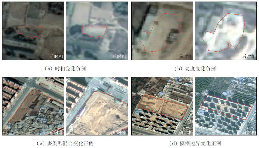
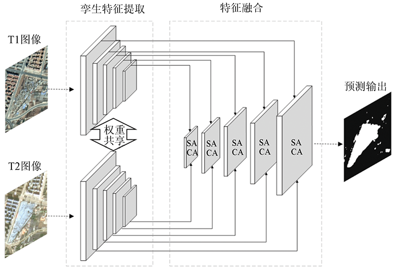
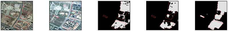
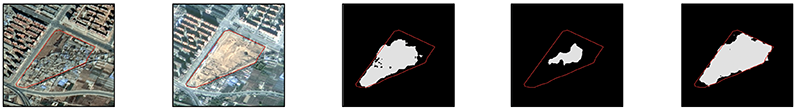
With the improvement of the spatial resolution of remote sensing images, the imaging features of ground objects have become increasingly complex. As a result, the change detection methods of remote sensing images based on texture expression and local semantics are difficult to meet the demand. To improve the change detection accuracy of high-resolution remote sensing images, this study constructed a large-scale remote sensing-based human activity change detection dataset (HRHCD-1.0) with a high resolution of 0.8~2 m. Moreover, this study designed an attention-based Siamese change detection network with a strong capability to extract contextual semantic features by introducing spatial attention and channel attention mechanisms. In the model comparative experiment, the attention-based Siamese change detection network proposed in this study increased the mean intersection over union on the validation set by 24% and showed more complete detection results compared to the models using non-attention mechanisms, effectively alleviating the problems of poor boundary, local omission, and holes of models using non-attention mechanisms. The post-processing method allows for small polygon removal, hole filling, and graphic smoothing of the detection results, improving the processing graphic effects of polygons. Furthermore, the increase in the sample size in the training of change detection significantly improves the application accuracy and generalization ability of the attention-based Siamese change detection network proposed in this study.
Tewkesbury A P, Comber A J, Tate N J, et al. A critical synjournal of remotely sensed optical image change detection techniques[J]. Remote Sensing of Environment, 2015, 160:1-14.
doi: 10.1016/j.rse.2015.01.006
[2]
Bruzzone L, Prieto F. Automatic analysis of the difference image for unsupervised change detection[J]. IEEE Transactions on Geoscience and Remote Sensing, 2000, 38(3):1171-1182.
doi: 10.1109/36.843009
[3]
Celik T. Unsupervised change detection in satellite images using principal component analysis and K-means clustering[J]. IEEE Geoscience and Remote Sensing Letters, 2009, 6(4):772-776.
doi: 10.1109/LGRS.2009.2025059
Zhang L P, Wu C. Advance and future development of change detection for multi-temporal remote sensing imagery[J]. Acta Geodaetica et Cartographica Sinica, 2017, 46(10):1447-1459.
[5]
Saux B L, Randrianarivo H. Urban change detection in SAR images by interactive learning[C]// IEEE International Geoscience and Remote Sensing Symposium (IGARSS), 2013:3990-3993.
[6]
Jackson R D. Spectral indices in N-space[J]. Remote Sensing of Environment, 1983, 13(5):409-421.
doi: 10.1016/0034-4257(83)90010-X
Huang W, Huang J L, Wang L H, et al. Remote sensing image change detection based on change vector analysis of PCA compoment[J]. Remote Sensing for Land and Resources, 2016, 28(1):22-27.doi: 10.6046/gtzyyg.2016.01.04.
doi: 10.6046/gtzyyg.2016.01.04
Li L, Shu N, Wang K, et al. Change detection method for remote sensing images based on multi-features fusion[J]. Acta Geodaetica et Cartographica Sinica, 2014, 43(9):945-953.
[9]
Zhang H, Gong M G, Zhang P Z, et al. Feature-level change detection using deep representation and feature change analysis for multispectral imagery[J]. IEEE Geoscience and Remote Sensing Letters, 2016, 13(11):1666-1670.
doi: 10.1109/LGRS.2016.2601930
[10]
Peng D F, Zhang Y J, Guan H Y. End-to-end change detection for high resolution satellite images using improved UNet++[J]. Remote Sensing, 2019, 11(11):1382.
doi: 10.3390/rs11111382
[11]
Chen H, Shi Z. A spatial-temporal attention-based method and a new dataset for remote sensing image change detection[J]. Remote Sensing, 2020, 12(10):1662.
doi: 10.3390/rs12101662
[12]
Peng D, Bruzzone L, Zhang Y, et al. SemiCDNet:A semisupervised convolutional neural network for change detection in high resolution remote-sensing images[J]. IEEE Transactions on Geoscience and Remote Sensing, 2021, 59(7):5891-5906.
doi: 10.1109/TGRS.2020.3011913
[13]
Ji S P, Wei S Q, Lu M, et al. Fully convolutional networks for multisource building extraction from an open aerial and satellite imagery data set[J]. IEEE Transactions on Geoscience and Remote Sensing, 2019, 57(1):574-586.
doi: 10.1109/TGRS.2018.2858817
[14]
Bourdis N, Marraud D, Sahbi H. Constrained optical flow for aerial image change detection[C]// 2011 IEEE International Geoscience and Remote Sensing Symposium, 2011:4176-4179.
[15]
Yang K P, Xia G S, Liu Z C, et al. Asymmetric siamese networks for semantic change detection[C/OL].[2020-10-12].https://arxiv.org/abs/2010.05687v1.
[16]
Daudt R C, Saux B L, Boulch A, et al. Multitask learning for large-scale semantic change detection[J]. Computer Vision and Image Understanding, 2019, 187:102783.
doi: 10.1016/j.cviu.2019.07.003
[17]
Daudt R C, Saux B L, Boulch A. Fully convolutional siamese networks for change detection[C]// 2018 25th IEEE International Conference on Image Processing (ICIP).IEEE, 2018.
[18]
Chen J, Yuan Z, Peng J, et al. DASNet:Dual attentive fully convolutional siamese networks for change detection of high resolution satellite images[J]. IEEE Journal of Selected Topics in Applied Earth Observations and Remote Sensing, 2021, 14:1194-1206.
doi: 10.1109/JSTARS.4609443
 2022, Vol. 34
  ), 王懿哲, 刘书含, 岳明宇, 王艺颖, 赵世湖