Please wait a minute...
 
国土资源遥感  2018, Vol. 30 Issue (3): 96-105    DOI: 10.6046/gtzyyg.2018.03.14
     本期目录 | 过刊浏览 | 高级检索 |
基于Landsat8数据的近海养殖区自动提取方法研究
武易天1,2, 陈甫1(), 马勇1, 刘建波1, 李信鹏1
1. 中国科学院遥感与数字地球研究所,北京 100101
2. 中国科学院大学,北京 100049
Research on automatic extraction method for coastal aquaculture area using Landsat8 data
Yitian WU1,2, Fu CHEN1(), Yong MA1, Jianbo LIU1, Xinpeng LI1
1. Institute of Remote Sensing and Digital Earth, CAS, Beijing 100101, China
2. University of Chinese Academy of Science, Beijing 100049, China
全文: PDF(7763 KB)   HTML  
输出: BibTeX | EndNote (RIS)      
摘要 

利用遥感影像进行近海养殖区提取,是近海渔业资源监管的一种有效手段。然而由于近海养殖区受海水叶绿素和悬浮泥沙浓度差异分布的影响,海域水色背景往往较为复杂,使得传统近海养殖区提取方法很难取得理想效果。为了准确提取复杂水色背景下的近海养殖区,提出一种结合光谱和纹理信息的养殖区自动提取方法。首先,利用基于正交子空间投影的约束能量最小化(orthogonal subspace projection-weighted constrained energy minimization,OWCEM)方法增强近海养殖区信息; 然后,利用近海养殖区的空间纹理信息,使用局部标准差自适应分割法(standard deviation adaptive segmentation,SDAS)对影像进行划分; 最后,基于分割图像对近海养殖区进行自动提取。选取山东桑沟湾养殖海域和福建三都澳养殖海域为实验区,采用Landsat8数据对所提方法进行近海养殖区提取实验,结果表明: 在复杂水色背景下,该方法能够准确快速地识别出近海养殖区的分布情况,在2个实验区都能达到93%以上的准确率,为近海养殖区自动提取提供了一种新的有效方法。

服务
把本文推荐给朋友
加入引用管理器
E-mail Alert
RSS
作者相关文章
武易天
陈甫
马勇
刘建波
李信鹏
关键词 近海养殖区提取标准差自适应分割(SDAS)复杂背景基于正交子空间投影的约束能量最小化(OWCEM)    
Abstract

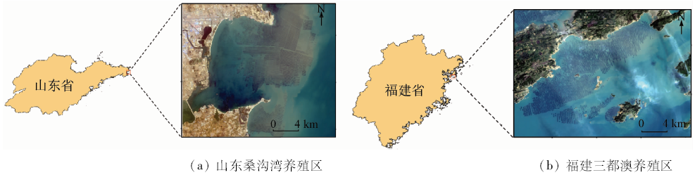
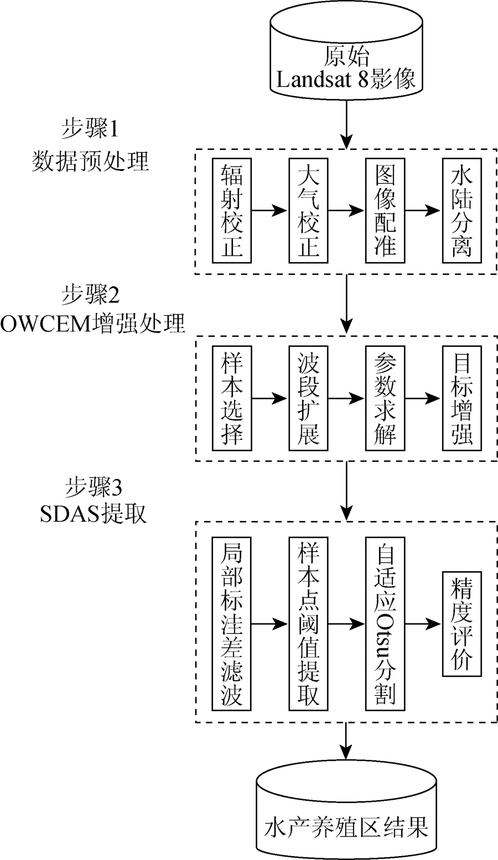
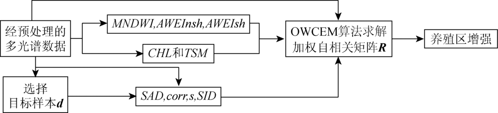
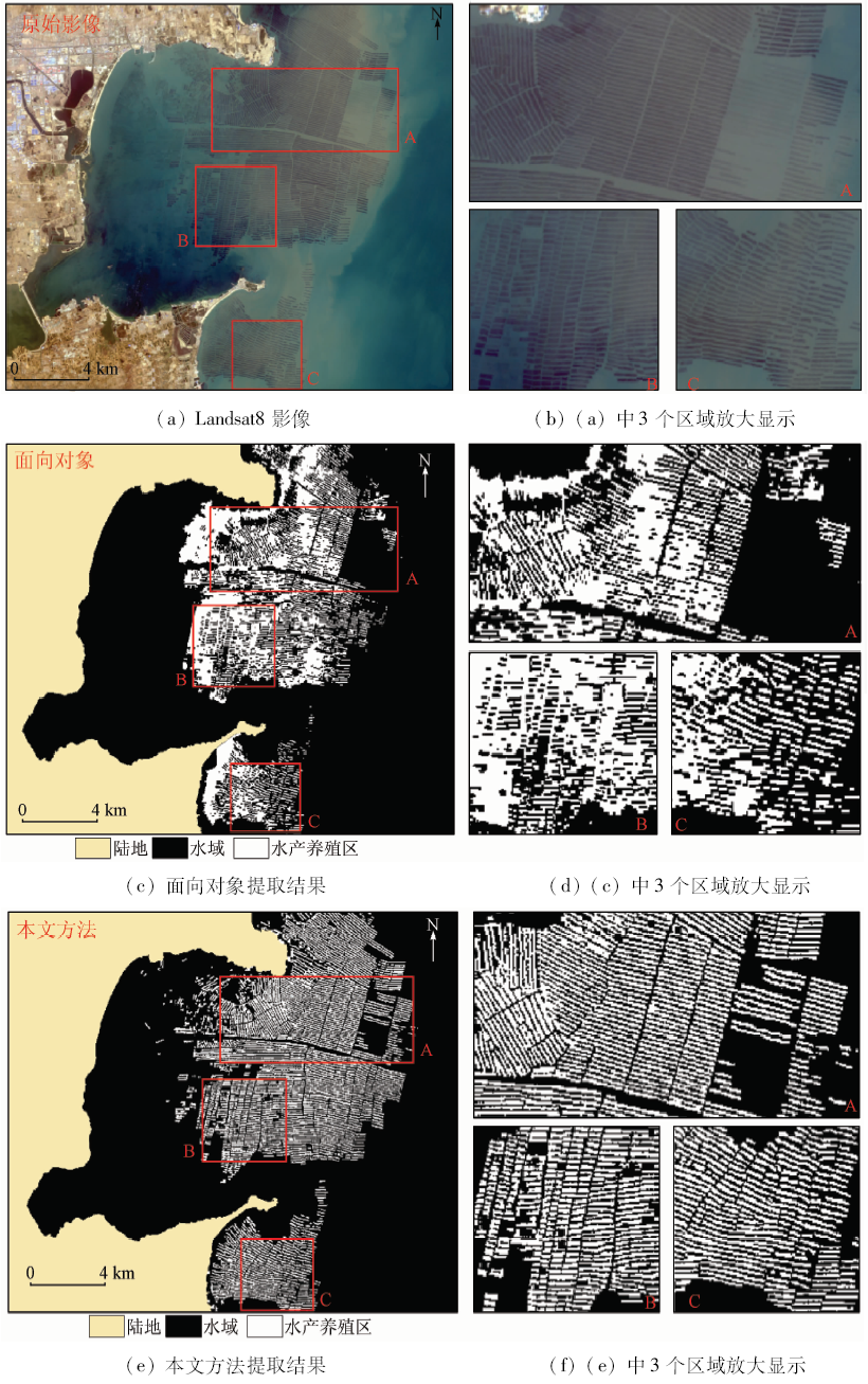
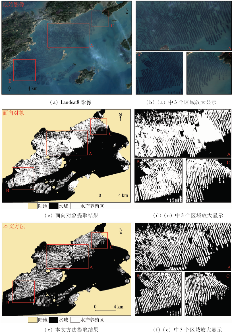
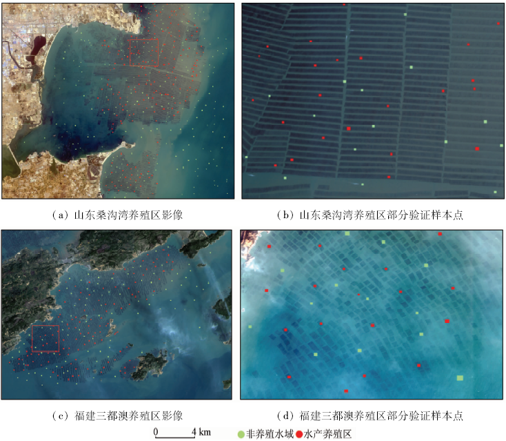
During coastal resource monitoring, it is an effective way to extract aquaculture region using remote sensing data, whereas the water color in coastal region is complexly influenced by the distribution difference of chlorophyll-a and total suspended sediment concentration. And it would be difficult to accurately extract the aquaculture region with complex background using traditional methods. In view of the above problem, the authors proposed an algorithm for automatic coastal aquaculture area extraction combined with spectral and spatial information of aquaculture. Firstly, orthogonal subspace projection-weighted constrained energy minization method (OWCEM) was used to enhance the information of coastal aquaculture area. Secondly, by using the spatial texture information of the coastal aquaculture area, standard deviation adaptive segmentation (SDAS) method was used to automatically extract the cultivation area. In order to verify the accuracy of the proposed algorithm, the authors selected Sanggou Bay in Shandong and Sanduao Bay in Fujian as test regions and conducted the area extraction using Landsat8 data. The experimental results show that the proposed method can rapidly and accurately identify the distribution of coastal aquaculture area in complex background color and can reach about 93% accuracy rate with a low missing rate. The method could provide a new and effective means for automatic extraction of offshore aquaculture area.

Key wordscoastal aquaculture region extraction    standard deviation adaptive segmentation(SDAS)    complex background    orthogonal subspace projection-weighted constrained energy minization(OWCEM)
收稿日期: 2017-01-19      出版日期: 2018-09-10
:  TP751.1  
基金资助:中国科学院135突破项目资助
通讯作者: 陈甫
作者简介: 武易天(1993-),男,硕士研究生,主要研究方向为遥感图像处理、目标提取和分类。Email: wuyt@radi.ac.cn。
引用本文:   
武易天, 陈甫, 马勇, 刘建波, 李信鹏. 基于Landsat8数据的近海养殖区自动提取方法研究[J]. 国土资源遥感, 2018, 30(3): 96-105.
Yitian WU, Fu CHEN, Yong MA, Jianbo LIU, Xinpeng LI. Research on automatic extraction method for coastal aquaculture area using Landsat8 data. Remote Sensing for Land & Resources, 2018, 30(3): 96-105.
链接本文:  
https://www.gtzyyg.com/CN/10.6046/gtzyyg.2018.03.14      或      https://www.gtzyyg.com/CN/Y2018/V30/I3/96
Fig.1  实验区覆盖范围示意图
Fig.2  水产养殖区不同的养殖方式
Fig.3  水产养殖区提取方法(OWCEM-SDAS)流程图
特征信息 特征指数 数学表达式
光谱特征 MNDWI MNDWI=(band3-band6)/(band3+band6)
AWEInsh(归一化) AWEInsh=4(band3-band6)-(0.25band5+2.75band7)band3+band5+band6+band7
AWEIsh(归一化) AWEIsh=band2+2.5band3-1.5(band5+band6)-0.25band7band2+band3+band5+band6+band7
CHL CHL=8.48band4/band1
TSM TSM=0.028band2+0.019band3-5.31band3/band2+0.537
特征信息 特征指数 数学表达式
相关性特征 SAD SAD=cos-1(xTyxy)
corr corr=x-x-Ty-y-x-x-y-y-
s s=x-y
SID SID=D(xy)+D(yx) Dxy=l=1Lpllnpl/qlDyx=l=1Lqllnql/pl
pl=xl/j=1Lxjql=yl/j=1Lyj
Tab.1  波段扩展中所包含的特征指数
Fig.4  OWCEM算法流程图
Fig.5  山东桑沟湾水产养殖区提取结果
Fig.6  福建三都澳水产养殖区提取结果
Fig.7  验证样本点在实验区参考影像中的分布
数据类别 面向对象方法 本文方法 总像元
水产养
殖区
非养殖
水域
水产养
殖区
非养殖
水域
水产养
殖区
1 060 668 1 624 104 1 728
非养殖
水域
134 784 32 886 918
合计 1 194 1 452 1 656 990 2 676
Tab.2  山东桑沟湾区域提取结果混淆矩阵
数据类别 面向对象方法 本文方法 总像元
水产养
殖区
非养殖
水域
水产养
殖区
非养殖
水域
水产养
殖区
1 878 762 2 436 204 2 640
非养殖
水域
348 2 054 137 2 265 2 402
合计 2 226 2 816 2 573 2 469 5 042
Tab.3  
实验描述 山东桑沟湾实验区 福建三都澳实验区
面向对象 本文方法 面向对象 本文方法
用户精度 88.78 98.07 84.37 94.68
制图精度 61.34 93.98 71.14 92.27
Kappa系数 57.03 91.31 71.37 90.77
总体精度 69.69 94.86 77.98 93.24
Tab.4  
[1] FAO. The State of World Fisheries and Aquaculture 2014[R]. Rome:FAO, 2014: 40-41.
[2] 程田飞, 周为峰, 樊伟 . 水产养殖区域的遥感识别方法进展[J]. 国土资源遥感, 2012,24(3):1-5.doi: 10.6046/gtzyyg.2012.03.01.
doi: 10.6046/gtzyyg.2012.03.01
Cheng T F, Zhou W F, Fan W . Progress in the methods for extracting aquaculture areas from remote sensing data[J]. Remote Sensing for Land and Resources, 2012,24(3):1-5.doi: 10.6046/gtzyyg.2012.03.01.
[3] 马艳娟, 赵冬玲, 王瑞梅 , 等. 基于ASTER数据的近海水产养殖区提取方法[J]. 农业工程学报, 2010,26(14):120-124.
Ma Y J, Zhao D L, Wang R M , et al. Offshore aquatic farming areas extraction method based on ASTER data[J]. Transactions of the CSAE, 2010,26(14):120-124.
[4] 周小成, 汪小钦, 向天梁 , 等. 基于ASTER影像的近海水产养殖信息自动提取方法[J]. 湿地科学, 2006,4(1):64-68.
doi: 10.3969/j.issn.1672-5948.2006.01.010
Zhou X C, Wang X Q, Xiang T L , et al. Method of automatic extracting seaside aquaculture land based on ASTER remote sensing image[J]. Wetland Science, 2006,4(1):64-68.
[5] 林桂兰, 孙飒梅, 曾良杰 , 等. 高分辨率遥感技术在厦门海湾生态环境调查中的应用[J]. 台湾海峡, 2003,22(2):242-247.
doi: 10.3969/j.issn.1000-8160.2003.02.018
Lin G L, Sun S M, Zeng L J , et al. Application of high resolution satellite remote sensing in survey of ecological environment at Xiamen Bay[J]. Journal of Oceanography in Taiwan Strait, 2003,22(2):242-247.
[6] 孙晓宇, 苏奋振, 周成虎 , 等. 基于RS与GIS的珠江口养殖用地时空变化分析[J]. 资源科学, 2010,32(1):71-77.
Sun X Y, Su F Z, Zhou C H , et al. Analyses on spatial-temporal changes in aquaculture land in coastal areas of the Pearl River Estuarine[J]. Resources Science, 2010,32(1):71-77.
[7] 卢业伟, 李强子, 杜鑫 , 等. 基于高分辨率影像的近海养殖区的一种自动提取方法[J]. 遥感技术与应用, 2015,30(3):486-494.
doi: 10.11873/j.issn.1004-0323.2015.3.0486
Lu Y W, Li Q Z, Du X , et al. A method of coastal aquaculture area automatic extraction with high spatial resolution images[J]. Remote Sensing Technology and Application, 2015,30(3):486-494.
[8] Ji L Y, Geng X R, Sun K , et al. Target detection method for water mapping using Landsat 8 OLI/TIRS imagery[J]. Water, 2015,7(2):794-817.
doi: 10.3390/w7020794
[9] Chen J, Chen J, Liao A P , et al. Global land cover mapping at 30 m resolution:A POK-based operational approach[J]. ISPRS Journal of Photogrammetry and Remote Sensing, 2015,103:7-27.
doi: 10.1016/j.isprsjprs.2014.09.002
[10] Farrand W H, Harsanyi J C . Mapping the distribution of mine tailings in the Coeur d’Alene River Valley,Idaho,through the use of a constrained energy minimization technique[J]. Remote Sensing of Environment, 1997,59(1):64-76.
doi: 10.1016/S0034-4257(96)00080-6
[11] Geng X R, Ji L Y, Sun K , et al. CEM:More bands,better performance[J]. IEEE Geoscience and Remote Sensing Letters, 2014,11(11):1876-1880.
doi: 10.1109/LGRS.2014.2312319
[12] Xu H Q . Modification of normalised difference water index (NDWI) to enhance open water features in remotely sensed imagery[J]. International Journal of Remote Sensing, 2006,27(14):3025-3033.
doi: 10.1080/01431160600589179
[13] Feyisa G L, Meilby H, Fensholt R , et al. Automated water extraction index:A new technique for surface water mapping using Landsat imagery[J]. Remote Sensing of Environment, 2014,140:23-35.
doi: 10.1016/j.rse.2013.08.029
[14] 邬明权, 韩松, 赵永清 , 等. 应用Landsat TM影像估算渤海叶绿素a和总悬浮物浓度[J]. 遥感信息, 2012,27(4):91-95.
doi: 10.3969/j.issn.1000-3177.2012.04.016
Wu M Q, Han S, Zhao Y Q , et al. Quantitative estimation of chlorophyll-a and total suspended matter concentration with Landsat TM[J]. Remote Sensing Information, 2012,27(4):91-95.
[15] Chang C I . An information-theoretic approach to spectral variability,similarity,and discrimination for hyperspectral image analysis[J]. IEEE Transactions on Information Theory, 2000,46(5):1927-1932.
doi: 10.1109/18.857802
[16] Otsu N . A threshold selection method from gray-level histograms[J]. IEEE Transactions on Systems,Man,and Cybernetics, 1979,9(1):62-66.
doi: 10.1109/TSMC.1979.4310076
[1] 曲海成, 王雅萱, 申磊. 多感受野特征与空谱注意力结合的高光谱图像超分辨率算法[J]. 自然资源遥感, 2022, 34(1): 43-52.
[2] 刘万军, 高健康, 曲海成, 姜文涛. 多尺度特征增强的遥感图像舰船目标检测[J]. 自然资源遥感, 2021, 33(3): 97-106.
[3] 仇一帆, 柴登峰. 无人工标注数据的Landsat影像云检测深度学习方法[J]. 国土资源遥感, 2021, 33(1): 102-107.
[4] 卫虹宇, 赵银娣, 董霁红. 基于改进RetinaNet的冷却塔目标检测[J]. 国土资源遥感, 2020, 32(4): 68-73.
[5] 刘尚旺, 崔智勇, 李道义. 基于Unet网络多任务学习的遥感图像建筑地物语义分割[J]. 国土资源遥感, 2020, 32(4): 74-83.
[6] 梁凯旋, 章桂芳, 张浩然. 一种综合DEM和遥感影像提取洪积扇的方法[J]. 国土资源遥感, 2020, 32(2): 138-145.
[7] 宋仁波, 朱瑜馨, 丁上珊, 贺巧宁, 王细元, 王月香. 基于GIS空间分析的任意多边形骨架线自动提取方法[J]. 国土资源遥感, 2020, 32(1): 51-59.
[8] 吴柳青, 胡翔云. 基于多尺度多特征的高空间分辨率遥感影像建筑物自动化检测[J]. 国土资源遥感, 2019, 31(1): 71-78.
[9] 张永梅, 孙海燕, 胥玉龙. 一种改进的基于超像素的多光谱图像分割方法[J]. 国土资源遥感, 2019, 31(1): 58-64.
[10] 余健, 姚云军, 赵少华, 贾坤, 张晓通, 赵祥, 孙亮. 基于改进的METRIC模型的农田潜热通量估算[J]. 国土资源遥感, 2018, 30(3): 83-88.
[11] 杨军, 裴剑杰. 一种改进的ICM遥感影像分割算法[J]. 国土资源遥感, 2018, 30(3): 18-25.
[12] 王立娟, 靳晓, 贾虎军, 唐尧, 马国超. 基于国产高分卫星数据的矿山环境变化检测[J]. 国土资源遥感, 2018, 30(3): 151-158.
[13] 廖戬, 顾行发, 占玉林, 张雅洲, 任芯雨, 师帅一. 高分一号卫星影像谐波模型模拟方法研究[J]. 国土资源遥感, 2018, 30(3): 106-112.
[14] 杨亮, 贾益, 江万寿, 张过. 基于观测角信息的HJ-1A/B卫星光学影像几何精纠正[J]. 国土资源遥感, 2018, 30(2): 60-66.
[15] 朱欣然, 吴波, 张强. 一种改进CVAPS的LUCC分类自动更新方法[J]. 国土资源遥感, 2018, 30(2): 29-37.
Viewed
Full text


Abstract

Cited

  Shared   
  Discussed   
京ICP备05055290号-2
版权所有 © 2015 《自然资源遥感》编辑部
地址:北京学院路31号中国国土资源航空物探遥感中心 邮编:100083
电话:010-62060291/62060292 E-mail:zrzyyg@163.com
本系统由北京玛格泰克科技发展有限公司设计开发