Please wait a minute...
 
国土资源遥感  2020, Vol. 32 Issue (1): 51-59    DOI: 10.6046/gtzyyg.2020.01.08
     技术方法 本期目录 | 过刊浏览 | 高级检索 |
基于GIS空间分析的任意多边形骨架线自动提取方法
宋仁波1,2, 朱瑜馨1, 丁上珊1, 贺巧宁1, 王细元1, 王月香1
1. 淮阴师范学院城市与环境学院,淮安 223300
2. 南京信息工程大学滨江学院,无锡 214105
An automatic method for extracting skeleton lines from arbitrary polygons based on GIS spatial analysis
Renbo SONG1,2, Yuxin ZHU1, Shangshan DING1, Qiaoning HE1, Xiyuan WANG1, Yuexiang WANG1
1. School of Urban and Environmental Science, Huaiyin Normal University, Huai’an 223300, China
2. Binjiang College, Nanjing University of Information Science and Technology, Wuxi 214105, China
全文: PDF(4939 KB)   HTML  
输出: BibTeX | EndNote (RIS)      
摘要 

针对现有任意多边形骨架线提取方法存在的算法设计繁琐、代码实现复杂、实现成本高和周期长的缺点,提出一种基于地理信息系统(geographic information system,GIS)空间分析的任意多边形骨架线自动提取方法。首先,以电子地图为数据源,在ENVI和ArcGIS平台的支持下,通过调用ArcToolbox工具箱中的ENVI分类模型工具提取出空间对象的多边形矢量边界,并对其进行预处理; 其次,综合运用数据处理、空间分析和文件转换工具提取其骨架结点,并对其进行后处理; 再次,采用Python面向对象编程语言结合ArcPy站点包,通过编写脚本程序自动提取其骨架线; 然后,进一步利用ModelBuilder工具,通过构建模型实现骨架线的自动提取; 最后,将该方法分别应用于电子地图道路和建筑物多边形骨架线的提取。实验过程及其结果表明该方法具有一定有效性、实用性和可操作性。

服务
把本文推荐给朋友
加入引用管理器
E-mail Alert
RSS
作者相关文章
宋仁波
朱瑜馨
丁上珊
贺巧宁
王细元
王月香
关键词 任意多边形骨架线GIS空间分析    
Abstract

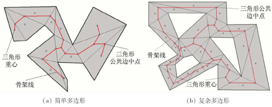
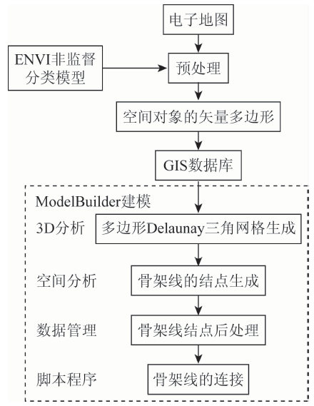
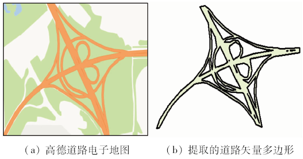
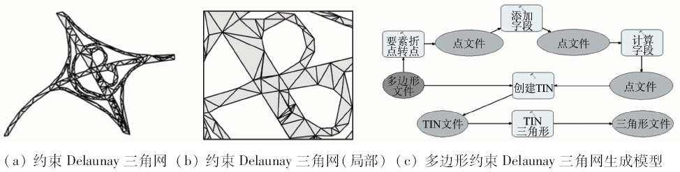
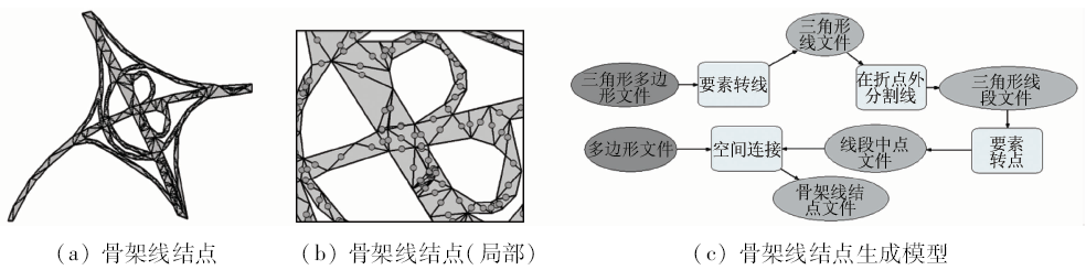
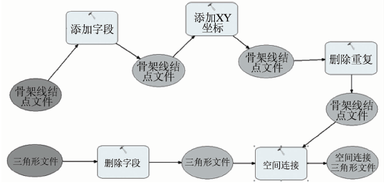
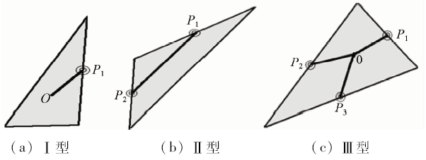
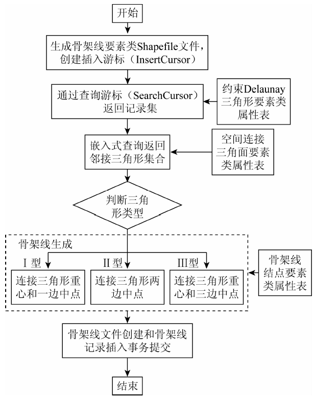
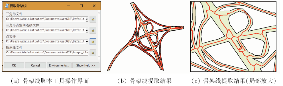
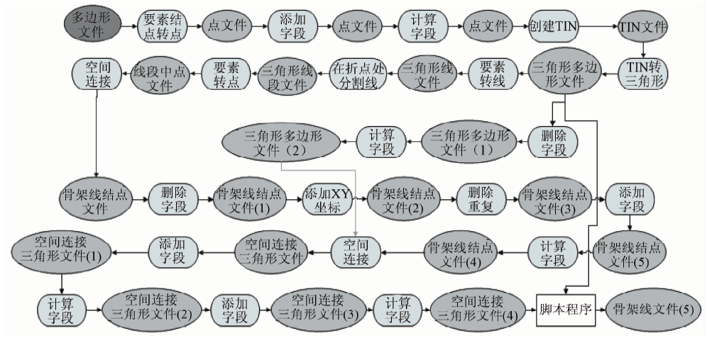
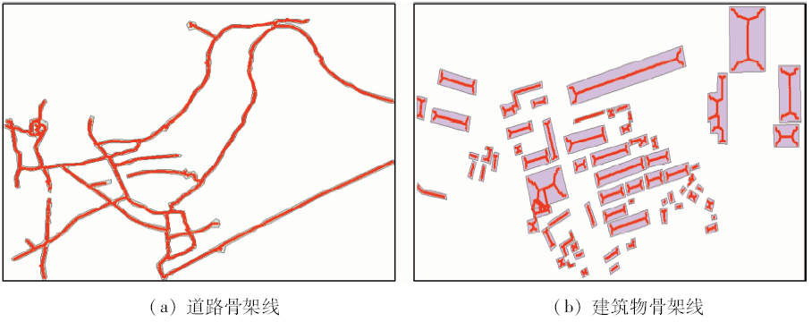
In view of the shortcomings such as complex algorithm design, code implementation, high cost and long period in the existent methods for extracting skeleton line from arbitrary polygons, the authors put forward an automatic method for extracting skeleton lines from arbitrary polygons based on geographic information system (GIS) space analysis. First, the electronic maps are taken as the data sources, and the polygon vector boundaries of the spatial objects are extracted and preprocessed by using the model tool of ENVI classification in the ArcToolbox toolbox with the platform support of the ENVI and the ArcGIS. Secondly, variable tools such as data processing, spatial analysis and file conversion are combined for extracting the nodes of skeleton lines and post-processing them. Then, the object oriented programming language of Python is used and combined with the ArcPy package for programming the scripts to extract the skeleton lines automatically. Furthermore, the visual modeling tool of ModelBuilder is used to build the model for extracting the skeleton lines automatically. Finally, the method is applied to the extraction of the skeleton line of the road and the building polygons boundary respectively. The experimental process and its results show that the method has characteristics of effectiveness, practicality and operability.

Key wordsarbitrary polygon    skeleton lines    GIS    spatial analysis
收稿日期: 2019-03-29      出版日期: 2020-03-14
:  TP751.1  
基金资助:国家自然科学基金项目“基于时空统计方法的多源遥感产品融合方法研究”(编号: 41401405);淮安市地理信息技术与应用重点实验室开放课题“淮安城市三维地理信息共享平台研究与开发”(编号: 15HAP002)
作者简介: 宋仁波(1974-),男,讲师,主要从事GIS应用与开发的教学与研究工作。Email: srb_id2000@aliyun.com。
引用本文:   
宋仁波, 朱瑜馨, 丁上珊, 贺巧宁, 王细元, 王月香. 基于GIS空间分析的任意多边形骨架线自动提取方法[J]. 国土资源遥感, 2020, 32(1): 51-59.
Renbo SONG, Yuxin ZHU, Shangshan DING, Qiaoning HE, Xiyuan WANG, Yuexiang WANG. An automatic method for extracting skeleton lines from arbitrary polygons based on GIS spatial analysis. Remote Sensing for Land & Resources, 2020, 32(1): 51-59.
链接本文:  
https://www.gtzyyg.com/CN/10.6046/gtzyyg.2020.01.08      或      https://www.gtzyyg.com/CN/Y2020/V32/I1/51
Fig.1  任意多边形骨架线提取原理示意图
Fig.2  任意多边形骨架线提取技术流程
Fig.3  实验数据的获取及预处理
Fig.4  任意多边形的约束Delaunay三角剖分及其模型
Fig.5  任意多边形的骨架线结点生成过程及其模型
Fig.6  骨架线结点后处理模型
OID* Shape* ID T1 J1
1 Polygon Z 1 1 25
2 Polygon Z 1 1 41
3 Polygon Z 2 2 39
4 Polygon Z 2 2 41
5 Polygon Z 3 3 35
6 Polygon Z 3 3 37
Tab.1  空间连接三角面要素类属性表
Fig.7  3种三角形类型的骨架线连接
OID* Shape * ID
1 Polygon Z 1
2 Polygon Z 2
3 Polygon Z 3
4 Polygon Z 4
5 Polygon Z 5
6 Polygon Z 6
Tab.2  约束Delaunay三角形要素类属性表
OID* Shape * ID
25 Point Z 25
41 Point Z 41
39 Point Z 39
41 Point Z 41
35 Point Z 35
37 Point Z 37
Tab.3  骨架线结点要素类属性表
Fig.8  骨架线连接的程序流程
Fig.9  脚本工具用户界面和骨架线提取结果
Fig.10  骨架线提取模型
Fig.11  应用测试及骨架线提取结果
多边形对象 约束Delaunay
三角面数量/个
骨架线提取模
型运行时间/s
道路 475 60
建筑物 735 80
Tab.4  骨架线提取实验分组统计
Fig.12  骨架线提取实验结果对比分析
[1] 王涛, 毋河海 . 顾及多因素的面状目标多层次骨架线提取[J]. 武汉大学学报(信息科学版), 2004,29(6):533-536.
Wang T, Wu H H . Extraction of hierarchical skeleton of areal object based on multivariate analysis[J]. Geomatics and Information Science of Wuhan University, 2004,29(6):533-536.
[2] 毋河海 . 地图综合理论基础与技术方法研究[M]. 北京: 测绘出版社, 2004.
Wu H H. Research on Map Generalization Theoretical Basis and Technical Method[M]. Beijing: Surveying and Mapping Press, 2004.
[3] 刘晶 . GIS制图中骨架提取算法的设计与实现[J]. 中南民族大学学报(自然科学版), 2007,26(4):78-80.
Liu J . Design and implementation of skeletonization in GIS cartography[J]. Journal of South-Central University for Nationalities (Natural Science Edition), 2007,26(4):78-80.
[4] 杜瑞颖, 刘镜年 . 面状地物名称注记的自动配置研究[J]. 测绘学报, 1999,28(4):365-368.
Du R Y, Liu J N . A research on automatic placement of geo-name in area feature[J]. Acta Geodaetica et Cartographica Sinica, 1999,28(4):365-368.
[5] 杨乃, 郭庆胜, 杨族桥 . 3维面状要素注记的自动配置研究[J]. 测绘科学技术学报, 2009,26(6):449-453.
Yang N, Guo Q S, Yang Z Q . Research on automatic placement of label in 3D area feature[J]. Journal of Geomatics Science and Technology, 2009,26(6):449-453.
[6] Han C Y, Kwon S H, Choi H I . Media axis transform of a planar domain with infinite curvature boundary points[J]. Computer Aided Geometric Design, 2012,29(6):281-295.
[7] Smogavec G, Žalik B . A fast algorithm for constructing approximate medial axis of polygons,using Steiner points[J]. Advances in Engineering Software, 2012,52:1-9.
[8] 刘小凤, 吴艳兰, 胡海 . 面状要素的多层次骨架线提取[J]. 测绘学报, 2013,42(4):588-594.
Liu X F, Wu Y L, Hu H . A method of extracting multiscale skeleton for polygonal shapes[J]. Acta Geodaetica et Cartographic Sinica, 2013,42(4):588-594.
[9] 王飞, 李成名 . 利用多边形骨架线生成房屋模型算法研究[J]. 测绘通报, 2017(1):69-73.
Wang F, Li C M . Research on algorithms for solving roof model by using straight skeleton of polygon[J]. Bulletin of Surveying and Mapping, 2017(1):69-73.
[10] 胡鹏, 王海军, 邵春丽 , 等. 论多边形中轴问题和算法[J]. 武汉大学学报(信息科学版), 2005,30(10):853-857.
Hu P, Wang H J, Shao C L , et al. Polygon medial axis problem and the algorithm[J]. Geomatics and Information Science of Wuhan University, 2005,30(10):853-857.
[11] 常小刚, 李玉龙 . 简单凸多边形中轴算法改进及实现[J]. 重庆工学院学报(自然科学版), 2009,23(9):176-180.
Chang X G, Li Y L . Improvement and realization of simple convex polygon medial axis algorithm[J]. Journal of Chongqing Institute of Technology(Natural Science), 2009,23(9):176-180.
[12] 刘秀芳, 杨永平, 罗吉 , 等. 基于内侧缓冲区算法的多边形骨架线提取模型[J]. 海洋测绘, 2010,30(5):46-48.
Liu X F, Yang Y P, Luo J , et al. Research on extracting polygon skeleton by using inner buffering algorithm[J]. Hydrographic Surveying and Charting, 2010,30(5):46-48.
[13] 陈涛, 艾廷华 . 多边形骨架线与形心自动搜寻算法研究[J]. 武汉大学学报(信息科学版), 2004,29(5):443-446,455.
Chen T, Ai T H . Automatic extraction of skeleton and center of area feature[J]. Geomatics and Information Science of Wuhan University, 2004,29(5):443-446,455.
[14] 王中辉, 闫浩文 . 多边形主骨架线提取算法的设计与实现[J]. 地理与地理信息科学, 2011,27(1):42-44,48.
Wang Z H, Yan H W . Design and implementation of an algorithm for extracting the main skeleton lines of polygons[J]. Geography and Geo-Information Science, 2011,27(1):42-44,48.
[15] 林福严, 郑奇志, 胡于进 , 等. 平面形体的中线提取及其应用[J]. 计算机应用与软件, 2000,17(6):61-65.
Lin F Y, Zheng Q Z, Hu Y J , et al. The transformation and application of medial axis of a planar shape[J]. Computer Applications and Software, 2000,17(6):61-65.
[16] 艾廷华, 郭仁忠 . 基于约束Delaunay结构的街道中轴线提取及网络模型建立[J]. 测绘学报, 2000,29(4):348-354.
Ai T H, Guo R Z . Extracting center-lines and building street network based on constrained Delaunay triangulation[J]. Acta Geodaetica et Cartographica Sinica, 2000,29(4):348-354.
[17] 乔庆华, 吴凡 . 河流中轴线提取方法研究[J]. 测绘通报, 2004(5):14-17.
Qiao Q H, Wu F . Research on methods for medial axis extraction[J]. Bulletin of Surveying and Mapping, 2004(5):14-17.
[18] 杜世宏, 杜道生, 樊红 , 等. 基于栅格数据提取主骨架线的新算法[J]. 武汉测绘科技大学学报, 2000,25(5):432-436.
Du S H, Du D S, Fan H , et al. A new raster-based algorithm for extracting main skeleton line of polygon[J]. Journal of Wuhan Technical University of Surveying and Mapping, 2000,25(5):432-436.
[19] 王辉连, 武芳, 王宝山 , 等. 利用数学形态学提取骨架线的改进算法[J]. 测绘科学, 2006,31(1):29-32.
Wang H L, Wu F, Wang B S , et al. Improved algorithm for extracting skeleton line of polygon based on mathematical morphology[J]. Science of Surveying and Mapping, 2006,31(1):29-32.
[20] 江岭, 杨昕, 汤国安 . 基于欧氏区域分配的面状河流中轴线提取方法研究[J]. 测绘通报, 2011(9):21-24.
Jiang L, Yang X, Tang G A . Research on methods for medial axis extraction based on Euclidean allocation[J]. Bulletin of Surveying and Mapping, 2011(9):21-24.
[21] 郭邦梅, 王涛, 赵荣 , 等. 面状要素骨架线提取算法的研究[J]. 测绘通报, 2010(12):17-19,53.
Gu B M, Wang T, Zhao R , et al. Research on algorithm of polygon skeleton line extracting[J]. Bulletin of Surveying and Mapping, 2010(12):17-19,53.
[22] Aurenhammer F . Weighted skeletons and fixed share decomposition[J]. Computational Geometry, 2008,40(2):93-101.
[23] 许丽敏, 薛安 . 基于Delaunay三角网与Voronoi图联合提取等高线骨架的地形重建算法研究[J]. 北京大学学报(自然科学版), 2009,45(4):647-652.
Xu L M, Xue A . Terrain reconstruction from contours by skeleton extraction using Delaunay triangulation and Voronoi diagram[J]. Acta Scientiarum Naturalium Universitatis Pekinensis, 2009,45(4):647-652.
[24] 陈秀萍, 黄彦锋, 吕翠华 . DLG制图数据生产中AutoCAD自动填充的实现方法[J]. 测绘科学, 2012,37(4):175-177.
Chen X P, Huang Y F, Lyu C H . Method of auto-hatch based on AutoCAD about 3D digital cartographic data[J]. Science of Surveying and Mapping, 2012,37(4):175-177.
[1] 李东, 唐诚, 邹涛, 侯西勇. 近海人工鱼礁水下物理状态探测与评估[J]. 自然资源遥感, 2022, 34(1): 27-33.
[2] 宋仁波, 朱瑜馨, 郭仁杰, 赵鹏飞, 赵珂馨, 朱洁, 陈颖. 基于多源数据集成的城市建筑物三维建模方法[J]. 自然资源遥感, 2022, 34(1): 93-105.
[3] 武艺杰, 孔雪松. 江苏省“生态-农业-建设”用地空间格局模拟及发展模式选择[J]. 自然资源遥感, 2022, 34(1): 238-248.
[4] 王爽, 张磊, 张俊勇, 王一乐. GIS在全民健身中的应用特征研究[J]. 自然资源遥感, 2021, 33(4): 265-271.
[5] 姚昆, 张存杰, 何磊, 李玉霞, 李小菊. 雅砻江中上游流域生态环境脆弱性动态评价及预测[J]. 国土资源遥感, 2020, 32(4): 199-208.
[6] 王永全, 李清泉, 汪驰升, 朱家松, 王新雨. 基于系留无人机的应急测绘技术应用[J]. 国土资源遥感, 2020, 32(1): 1-6.
[7] 施益强, 邓秋琴, 吴君, 王坚. 厦门市MODIS气溶胶光学厚度与空气质量指数的回归分析[J]. 国土资源遥感, 2020, 32(1): 106-114.
[8] 梅昭容, 李云驹, 康翔, 魏善宝, 潘剑君. 基于移动窗口分析法的矿区景观格局时空演变研究[J]. 国土资源遥感, 2019, 31(4): 60-68.
[9] 安全, 贺中华, 赵翠薇, 梁虹, 焦树林, 杨朝晖. 基于地貌视角的喀斯特流域水系分维估算方法适应性分析[J]. 国土资源遥感, 2019, 31(4): 104-111.
[10] 陈俊, 沈润平, 李博伦, 遆超普, 颜晓元, 周旻悦, 王绍武. 基于Logistic回归分析的塑料大棚遥感指数构建[J]. 国土资源遥感, 2019, 31(3): 43-50.
[11] 张瑜, 赵晓丽, 左丽君, 张增祥, 徐进勇. 黄土高原土地利用变化对生态系统服务价值的影响[J]. 国土资源遥感, 2019, 31(3): 132-139.
[12] 张珂, 刘建忠, 程维明. 月球哥白尼纪次级坑的形态特征及其空间分布[J]. 国土资源遥感, 2019, 31(1): 255-263.
[13] 姜文, 秦其明. 基于GIS的路网应急疏散脆弱性研究[J]. 国土资源遥感, 2019, 31(1): 277-282.
[14] 黄巧, 彭玉玲, 秦文杰. 老挝沙湾水经济区土地利用适宜性评价[J]. 国土资源遥感, 2018, 30(4): 156-162.
[15] 随欣欣, 眭素文. 基于MapGIS和ArcGIS的遥感解译成果图件数据库设计与实现[J]. 国土资源遥感, 2018, 30(4): 218-224.
Viewed
Full text


Abstract

Cited

  Shared   
  Discussed   
京ICP备05055290号-2
版权所有 © 2015 《自然资源遥感》编辑部
地址:北京学院路31号中国国土资源航空物探遥感中心 邮编:100083
电话:010-62060291/62060292 E-mail:zrzyyg@163.com
本系统由北京玛格泰克科技发展有限公司设计开发