1. School of Earth Science and Engineering, Sun Yat-Sen University, Guangzhou 510275, China 2. Guangdong Provincal Key Lab of Geodynamics and Geohazards, Guangzhou 510275, China 3. Southern Marine Science and Engineering Guangdong Laboratory (Zhuhai),Zhuhai 519000, China
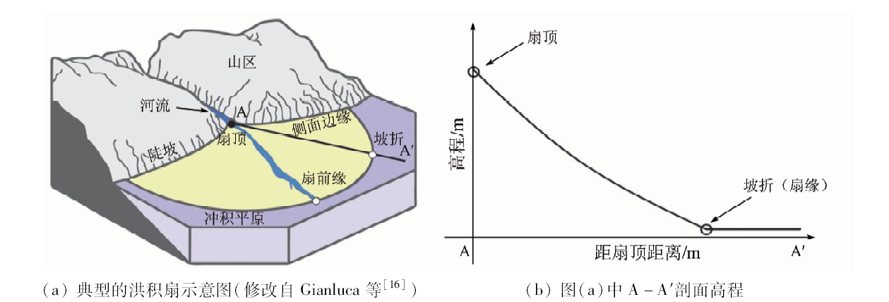
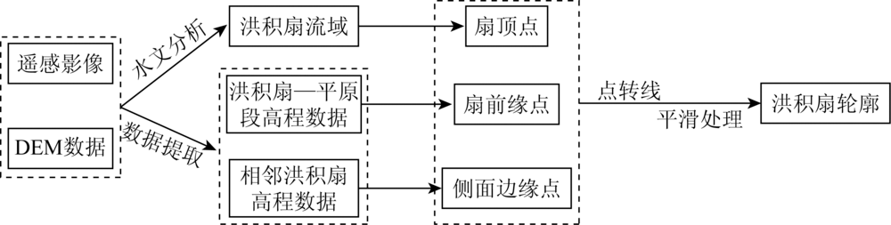
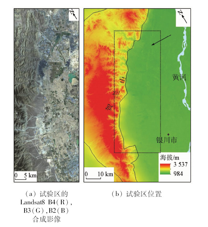
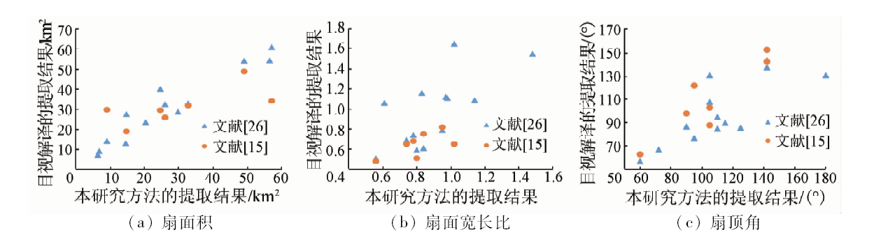
Based on DEM and remote sensing data, this paper proposes a new method for extracting alluvial fan by determining the fan apex point, leading edge points and side edge points. Firstly, the fan apex point is determined by hydrological analysis. Secondly, the fan leading edge points are determined by DEM elevation fitting curve according to the obvious slope break at the boundary of alluvial fan and alluvial plain. Finally, the side edge points are interpreted by DEM elevation fitting curve and remote sensing data. Taking the eastern foot of Helan Mountain as a study case, the authors detected that the alluvial fans extracted by the proposed method are more objective and stable than visual interpretation from available studies. Moreover, this method can extract the alluvial fan more effectively under the complex condition with vegetation coverage and human activities, which is difficult for visual interpretation. The method is significant for alluvial fan extraction and also for the research on landform and sedimentary characteristics of alluvial fan.
梁凯旋, 章桂芳, 张浩然. 一种综合DEM和遥感影像提取洪积扇的方法[J]. 国土资源遥感, 2020, 32(2): 138-145.
Kaixuan LIANG, Guifang ZHANG, Haoran ZHANG. A method for extracting alluvial fan based on DEM and remote sensing data. Remote Sensing for Land & Resources, 2020, 32(2): 138-145.
Drew F. Alluvial and lacustrine deposits and glacial records of the upper Indus basin[J].Geological Society of London Quaterly Journal, 1873,29:441-471.
[2]
曹伯勋. 地貌学及第四纪地质学[M]. 武汉: 中国地质大学出版社, 1995: 70-75.
Cao B X. Geomorphology and quaternary geology[M]. Wuhan: China University of Geosciences Press, 1995: 70-75.
Bai M W, Xie X P, Chen Z C, et al. Geomorphological evolution of quaternary alluvial fans and its response to tectonic activity along the Fujiang River,northeastern Longmen Mountains[J]. Acta Sedimentologica Sinica, 2017,35(1):85-92.
doi: 10.14027/j.cnki.cjxb.2017.01.009
[5]
Lee J H, Chough S K, Jo H R. Development of a streamflow-dominated alluvial-fan system in the southwestern margin of Gyeongsang basin(Lower Cretaceous):Implications for initial basin-fill history[J]. Geosciences Journal, 2019,23(2):189-200.
doi: 10.1007/s12303-018-0073-5
[6]
Rockwell T K, Masana E, Sharp W D, et al. Late Quaternary slip rates for the southern Elsinore fault in the Coyote Mountains,southern California from analysis of alluvial fan landforms and clast provenance,soils and U-series ages of pedogenic carbonate[J]. Geomorphology, 2019,326:68-89.
doi: 10.1016/j.geomorph.2018.02.024
[7]
Blair T C. Sedimentology of the debris-flow-dominated Warm Spring Canyon alluvial fan,Death Valley,California[J]. Sedimentology, 1999,46(5):941-965.
doi: 10.1046/j.1365-3091.1999.00260.x
Mo D W, Zhu Z L, Wan L Y. The alluvial fans along the eastern foot of Helan Mountain[J]. Acta Scientiarum Naturalium Universitatis Pekinensis, 1999,35(6):91-98.
[9]
Blair T C, McPherson J G.Processes and forms of alluvial fans[M]. Berlin:Springer Netherlands, 2009: 413-467.
[10]
Tom G, Farr O A, Chadwick.Geomorphic processes and remote sensing signatures of alluvial fans in the Kun Lun Mountains,China[J]. Journal of Geophysical Research Planets, 1996,101(E10):23091-23100.
Chui W G, Mu G J, Xia B, et al. Evolution of alluvial fans at range-front of Tian Mountains in Manas River valley based on remote sensing technology[J].Geography and Geo-Information Science, 2006(3):39-42.
Xie X P, Bai M W, Chen Z C, et al. Remote sensing image interpretation and tectonic activity study of the active faults along the northeastern segment of the Longmenshan fault[J]. Remote Sensing for Land and Resources, 2019,31(1):237-246.doi: 10.6046/gtzyyg.2019.01.31.
[13]
陈颖. 祁连山北麓洪积扇坡度特征及其控制因素分析[D]. 兰州:兰州大学, 2016.
Chen Y. Characteristics and controlling factors of alluvial fan slopes in the northern piedmont of the Qilian Shan[D]. Lanzhou:Lanzhou University, 2016.
Li X P, Mo D W, Zhu Z L. Development of alluvial fans and their catchments in Houma basin[J]. Acta Geographica Sinica, 2006,61(3):241-248.
doi: 10.11821/xb200603002
Li S B, Zhang K, Zhang G F, et al. The relationship between alluvial fans and mountain uplift in Helanshan and Luoshan Mountains in northwestern China based on GIS technique[J]. Mountain research, 2015,33(3):268-278.
[16]
Gianluca N, Maria C Z, Iris J O, et al. Delineation of alluvial fans from digital elevation models with a GIS algorithm for the geomorphological mapping of the Earth and Mars[J]. Geomorphology, 2016,273:134-149.
doi: 10.1016/j.geomorph.2016.08.010
[17]
Argialas D P, Tzotos A. Automatic extraction of alluvial fans from ASTER L1 satellite data and a digital elevation model using object-oriented image [C]//Istanbul:Geomatica, 2004: 12-23.
[18]
Roberts N, Cunningham D. Automated alluvial fan discrimination, quaternary fault identification,and the distribution of tectonically reactivated crust in the Gobi Altai region,southern Mongolia[J]. International Journal of Remote Sensing, 2008,29(23):6957-6969.
doi: 10.1080/01431160802220227
Yang S W, Liu T, Feng G S, et al. Automatic extraction method of alluvial fan based on ETM+ images[J]. Science of Surveying and Mapping, 2013,38(3):166-168.
Department of Economic Geography,Institute of Geography,Chinese Academy of Sciences. General introduction of agricultural geography in China[M]. Beijing: Science Press, 1980: 3-9.
[21]
Wells S G, Harvey A M. Sedimentologic and geomorphic variations in storm generated alluvial fans,Howgill Fells,northwest England[J]. Geological Society of America Bulletin, 1987,98(2):182-198.
doi: 10.1130/0016-7606(1987)98<182:SAGVIS>2.0.CO;2
[22]
Saito K, Oguchi T. Slope of alluvial fans in humid regions of Japan,Taiwan and the Philippines[J]. Geomorphology, 2005,70:147-167.
doi: 10.1016/j.geomorph.2005.04.006
[23]
Harvey A, Mather A E, Stokes M. Alluvial fans:Geomorphology,sedimentology,dynamics-introduction,a review of alluvial fan research[J]. Geological Society London Special Publications, 2005,251(1):1-8.
doi: 10.1144/GSL.SP.2005.251.01.01
[24]
Guerit L, Metivier F, Devauchelle O, et al. Laboratory alluvial fans in one dimension[J]. Physical Review E Statistical Nonlinear and Soft Matter Physics, 2014,90(2):1-8.
[25]
Dechant L J, Pease P P, Tchakerian V P. Modelling alluvial fan morphology[J]. Earth Surface Processes and Landforms, 1999,24(7):641-652.
[26]
李新坡. 中国北方地区冲积扇地貌发育特征与影响因素分析[D]. 北京:北京大学, 2007.
Li X P. Geomorphology and affecting factors analysis of alluvial fans in north China[D]. Beijing:Peking University, 2007.
[27]
杨景春, 李有利. 地貌学原理[M]. 北京: 北京大学出版社, 2017: 37-42.
Yang J C, Li Y L. Fundamentals of geomorphology[M]. Beijing: Peking University Press, 2017: 37-42.
[28]
田明中, 程捷. 第四纪地质学与地貌学[M]. 北京: 地质出版社, 2008: 54-59.
Tian M Z, Chen J. Quaternary geology and geomorphology[M]. Beijing: Geological Publishing House, 2008: 54-59.
The China Earthquake Administration Research Group on the Active Fault Around Erdos Basin. The active fault around Erdos basin[M]. Beijing: Earthquake Press, 1987: 20-21.
Liu J H, Zhang P Z, Zheng D W, et al. The feature and pattern of late Cenozoic uplift and exhumation of the Helan Shan[J]. Scientia Sinica Terrae, 2010,40(1):50-60.
[31]
Darby B J, Ritts B D. Mesozoic contractional deformation in the middle of the Asian tectonic collage:The intraplate Western Ordos fold-thrust belt,China[J]. Earth and Planetary Science Letters, 2002,205(1-2):13-24.
doi: 10.1016/S0012-821X(02)01026-9
Shan P F, Wen J L, Qu X N. An approach to the characteristics of neotectonic movement in the eastern foot of Helan Mountains[J]. Arid Land Geography, 1991,14(2):15-20.
Yang G, Liu X N. The present research condition and development trend of remotely sensed imagery interpretation[J]. Remote Sensing for Land and Resources, 2004,16(2):7-10,15.doi: 10.6046/gtzyyg.2004.02.02.
[34]
Bull W B. The alluvial fan environment[J]. Progress in Physical Geography, 1977,1:222-270.
[35]
Oguchi T, Ohmori H. Analysis of relationships among alluvial-fan area,source basin area,basin slope,and sediment yield[J]. Zeitschrift Fur Geomorphologie, 1994,38(4):405-420.
 2020, Vol. 32
  ), 张浩然1,2