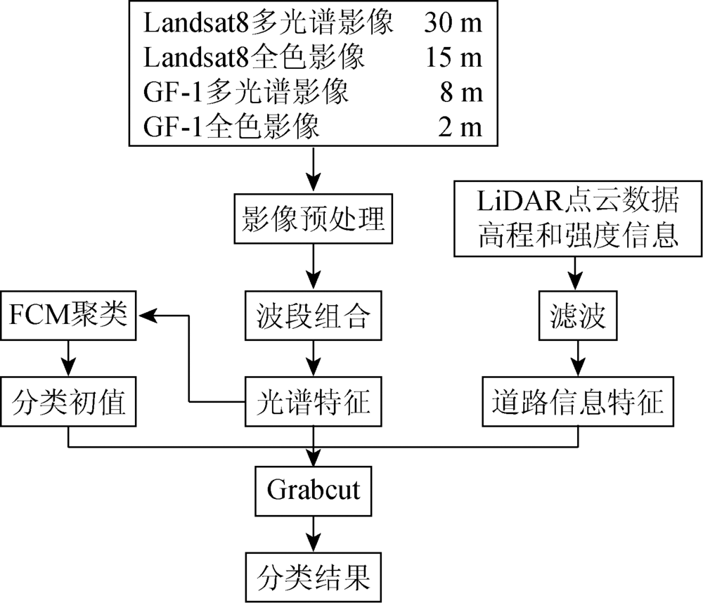
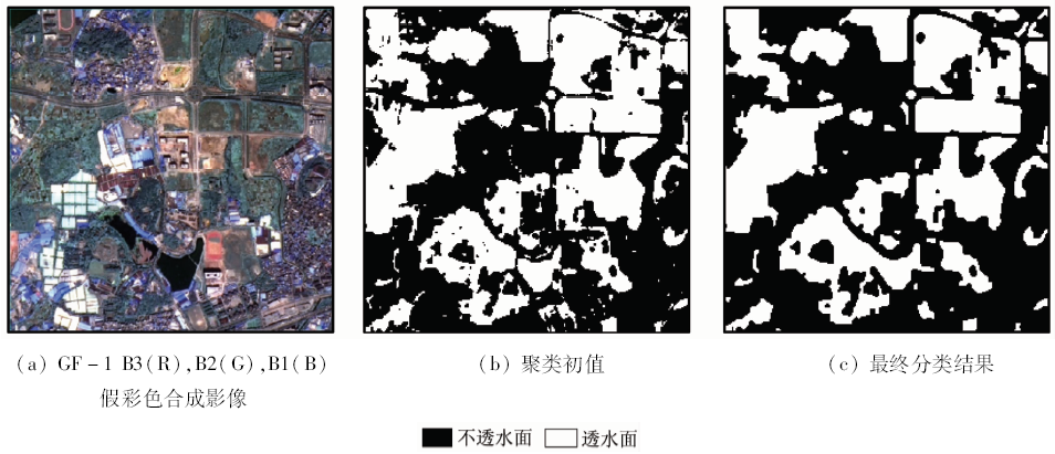
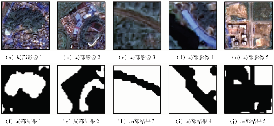
Impervious surface is a major indicator of rapid urbanization, which leads to urban waterlogging. In this study, the authors took the advantages of multi-spectral satellite imagery and LiDAR data based on Grabcut to extract impervious surfaces. Taking the Guangzhou City as a study case, the authors reveal that the method can reach higher overall accuracy and robustness than the traditional single-source method.
Ren J H, Wu S H, Zhou S L , et al. Advances in remote sensing research on urban impervious surface[J].Remote Sensing for Land and Resources, 2012(4):8-15.doi: 10.6046/gtzyyg.2012.04.02.
Cao L Q, Li P X, Zhang L P , et al. Estimating impervious surfaces using the Fuzzy ARTMAP[J]. Geomatics and Information Science of Wuhan University, 2012,37(10):1236-1239.
[4]
Sun G Y, Chen X L, Jia X P , et al. Combinational build-up index(CBI) for effective impervious surface mapping in urban areas[J]. IEEE Journal of Selected Topics in Applied Earth Observations and Remote Sensing, 2015,9(5):2081-2092.
doi: 10.1109/JSTARS.2015.2478914
[5]
Shahtahmassebi A R, Song J, Zheng Q , et al. Remote sensing of impervious surface growth:A framework for quantifying urban expansion and re-densification mechanisms[J]. International Journal of Applied Earth Observation and Geoinformation, 2016,46:94-112.
doi: 10.1016/j.jag.2015.11.007
[6]
Gao Z H, Zhang L, Liao M S, et al. Estimating urban impervious surface percentage with multi-source remote sensing data [C]//Proceedings of 2009 Joint Urban Remote Sensing Event.Shanghai,China:IEEE, 2009: 1-5.
[7]
Qiao Y, Liu H P, Bai M , et al. Extracting impervious surfaces from multi-source satellite imagery based on unified conceptual model by decision tree algorithm[J]. Science China Technological Sciences, 2010,53(S1):68-74.
doi: 10.1007/s11431-010-3207-1
[8]
Cai C, Li P J, Jin H R . Extraction of urban impervious surface using two-season worldview-2 images:A comparison[J]. Photogrammetric Engineering and Remote Sensing, 2016,82(5):335-349.
doi: 10.1016/S0099-1112(16)82014-5
[9]
Gao Z H, Liu X W. Support vector machine and object-oriented classification for urban impervious surface extraction from satellite imagery [C]//Proceeding of the Third International Conference on Agro-Geoinformatics.Beijing,China:IEEE, 2014: 1-5.
[10]
Zhang Y Z, Zhang H S, Lin H . Improving the impervious surface estimation with combined use of optical and SAR remote sensing images[J]. Remote Sensing of Environment, 2014,141:155-167.
doi: 10.1016/j.rse.2013.10.028
[11]
Kotarba A Z, Aleksandrowicz S . Impervious surface detection with nighttime photography from the international space station[J]. Remote Sensing of Environment, 2016,176:295-307.
doi: 10.1016/j.rse.2016.02.009
[12]
Hodgson M E, Jensen J R, Tullis J A , et al. Synergistic use of LiDAR and color aerial photography for mapping urban parcel imperviousness[J]. Photogrammetric Engineering and Remote Sensing, 2003,69(9):973-980.
doi: 10.14358/PERS.69.9.973
[13]
Im J, Lu Z Y, Rhee J , et al. Impervious surface quantification using a synjournal of artificial immune networks and decision/regression trees from multi-sensor data[J]. Remote Sensing of Environment, 2012,117:102-113.
doi: 10.1016/j.rse.2011.06.024
Xu H Q . A new remote sensing index for fastly extracting impervious surface information[J]. Geomatics and Information Science of Wuhan University, 2008,33(11):1150-1153.
[15]
Rouse J W, Haas R H, Schell J A, et al. Monitoring vegetation systems in the great plains with erts [C]//Proceedings of Third Earth Resources Technology Satellite-1 Symposium.Greenbelt:NASA, 1974,351:309-317.
[16]
Xu H Q . Modification of normalised difference water index(NDWI) to enhance open water features in remotely sensed imagery[J]. International Journal of Remote Sensing, 2006,27(14):3025-3033.
doi: 10.1080/01431160600589179
Gong L, Zhang Y S, Li Z G , et al. Automated road extraction from LiDAR data based on clustering of intensity[J].Bulletin of Surveying and Mapping, 2011(9):15-17,24.
Peng J G, Ma H C, Gao G , et al. Road extraction from airborne LiDAR point clouds data in urban area[J].Bulletin of Surveying and Mapping, 2012(9):16-19.
[19]
Boykov Y Y, Jolly M P. Interactive graph cuts for optimal boundary and region segmentation of objects in N-D images [C]//Proceedings of 2001 IEEE International Conference on Computer Vision.Vancouver:IEEE, 2001: 105-112.
[20]
Rother C, Kolmogorov V, Blake A . “GrabCut”:Interactive foreground extraction using iterated graph cuts[J]. ACM Transactions on Graphics, 2004,23(3):309-314.
doi: 10.1145/1015706
 2018, Vol. 30