Comparison of Landsat8 impervious surface extraction methods
Chang LIU1, Kang YANG1,2,3(), Liang CHENG1,2,3, Manchun LI1,2,3, Ziyan GUO1
1. School of Geographic and Oceanographic Sciences, Nanjing University, Nanjing 210023,China 2. Jiangsu Provincial Key Laboratory of Geographic Information Science and Technology, Nanjing 210023, China 3. Collaborative Innovation Center for the South Sea Studies, Nanjing 210023, China
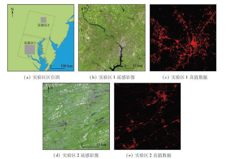
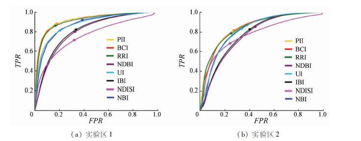
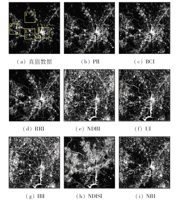
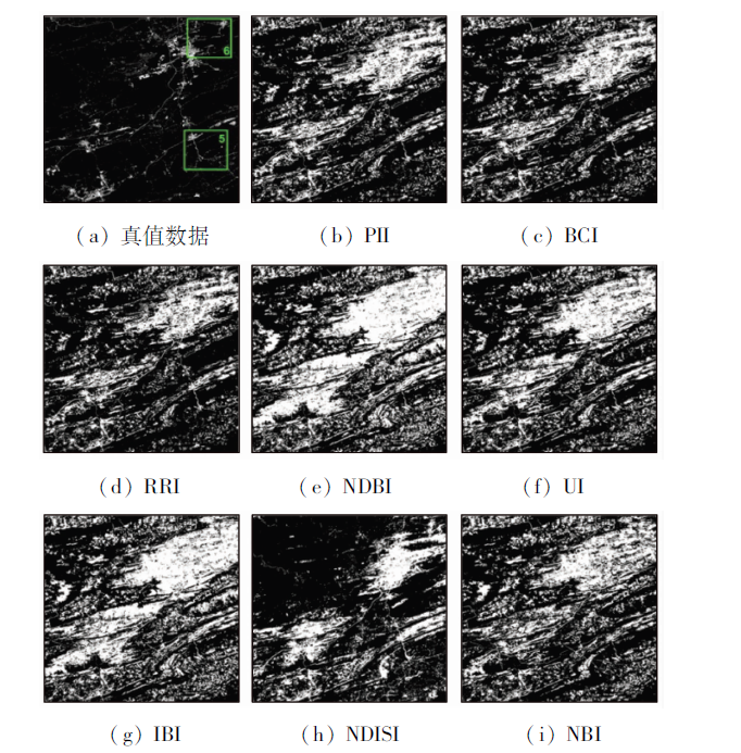
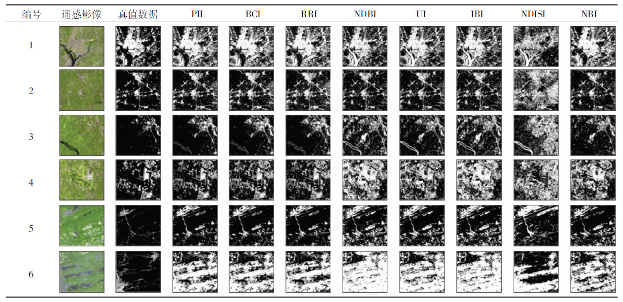
Impervious surface is an important land cover type. Extracting impervious surface from satellite images is crucial for land use and land cover change (LUCC) studies. Although several indexes have been proposed to detect impervious surface, there is a lack of systematic comparative analysis of these indexes. To address this problem, the authors estimated the performance of eight state-of-the-art impervious surface indexes using Landsat8 satellite images. The experimental results show that perpendicular impervious index (PII) performs best, yielding the highest detection accuracy of 89.6%. The accuracies of ratio resident-area index (RRI) and biophysical composition index (BCI) are slightly lower than the accuracy of PII, which are 87.5% and 87.4%, respectively. The accuracies of urban index (UI) and new built-up index (NBI) are 82.9% and 80.0%, respectively. Normalized difference impervious surface index (NDISI), normalized difference built-up index (NDBI), and index-based built-up index (IBI) fail to enhance the spectral characteristics of impervious surface from complex image background, thereby yielding the lowest accuracy (<75.0%). Importantly, the eight impervious surface indexes fail to distinguish the spectral characteristics of impervious surface from large bare land areas and the average detection accuracy is only 71.0%, hindering their applications in bare-land-rich areas.
Arnold C L, Gibbons C J . Impervious surface coverage:The emergence of a key environmental indicator[J]. Journal of the American Planning Association, 1996,62(2):243-258.
[2]
Zhang L, Weng Q, Shao Z . An evaluation of monthly impervious surface dyna-mics by fusing Landsat and MODIS time series in the Pearl River Delta,China,from 2000 to 2015[J]. Remote Sensing of Environment, 2017,201:99-114.
[3]
Slonecker E T, Jennings D B, Garofalo D . Remote sensing of impervious surfaces:A review[J]. Remote Sensing Reviews, 2001,20(3):227-255.
[4]
Song X P, Sexton J O, Huang C , et al. Characterizing the magnitude,timing and duration of urban growth from time series of Landsat-based estimates of impervious cover[J]. Remote Sensing of Environment, 2016,175:1-13.
[5]
Weng Q . Remote sensing of impervious surfaces in the urban areas:Requirements,methods,and trends[J]. Remote Sensing of Environment, 2012,117:34-49.
[6]
Dams J, Dujardin J, Reggers R , et al. Mapping impervious surface change from remote sensing for hydrological modeling[J]. Journal of Hydrology, 2013,485:84-95.
[7]
Sofia G, Roder G, Dalla F , et al. Flood dynamics in urbanised landscapes:100 years of climate and humans’ interaction[J]. Scientific Reports, 2017,7:40527.
[8]
Mathew A, Khandelwal S, Kaul N . Spatial and temporal variations of urban heat island effect and the effect of percentage impervious surface area and elevation on land surface temperature:Study of Chandigarh City,India[J]. Sustainable Cities and Society, 2016,26:264-277.
[9]
Xiao R, Ouyang Z, Zheng H , et al. Spatial pattern of impervious surfaces and their impacts on land surface temperature in Beijing,China[J]. Journal of Environmental Sciences, 2007,19(2):250-256.
Xu H Q . Quantitative analysis on the relationship of urban impervious surface with other components of the urban ecosystem[J]. Acta Ecologica Sinica, 2009,29(5):2456-2462.
[11]
Liu C, Shao Z, Chen M , et al. MNDISI:A multi-source composition index for impervious surface area estimation at the individual city scale[J]. Remote Sensing Letters, 2013,4(8):803-812.
Xu H Q . A new remote sensing index for fastly extracting impervious surface information[J]. Geomatics and Information Science of Wuhan University, 2008,33(11):1150-1153.
[13]
Yang L, Huang C, Homer C G , et al. An approach for mapping large-area impervious surfaces:Synergistic use of Landsat-7 ETM+ and high spatial resolution imagery[J]. Canadian Journal of Remote Sensing, 2003,29(2):230-240.
[14]
Cao X, Chen J, Imura H , et al. A SVM-based method to extract urban areas from DMSP-OLS and SPOT VGT data[J]. Remote Sensing of Environment, 2009,113(10):2205-2209.
[15]
Pandey B, Joshi P K, Seto K C . Monitoring urbanization dynamics in India using DMSP/OLS night time lights and SPOT-VGT data[J]. International Journal of Applied Earth Observation and Geoinformation, 2013,23:49-61.
[16]
Wu C S, Murray A T . Estimating impervious surface distribution by spectral mixture analysis[J]. Remote Sensing of Environment, 2003,84(4):493-505.
[17]
Yang J, He Y . Automated mapping of impervious surfaces in urban and suburban areas:Linear spectral unmixing of high spatial resolution imagery[J]. International Journal of Applied Earth Observation and Geoinformation, 2017,54:53-64.
[18]
Deng C, Wu C . BCI:A biophysical composition index for remote sensing of urban environments[J]. Remote Sensing of Environment, 2012,127:247-259.
[19]
Kawamura M, Jayamana S, Tsujiko Y . Relation between social and environmental conditions in Colombo Sri Lanka and the urban index estimated by satellite remote sensing data[J]. The International Archives of Photogrammetry and Remote Sensing, 1996,31:321-326.
[20]
Xu H . A new index for delineating built-up land features in satellite imagery[J]. International Journal of Remote Sensing, 2008,29(14):4269-4276.
Chen J L, Liu Y X, Li M C , et al. Extracting remote sensing information of residential areas based on the analysis of normalized difference index[J]. Science of Surveying and Mapping, 2010,35(2):204-206.
Tian Y G, Xu Y, Yang X N . Perpendicular impervious index for remote sensing of multiple impervious surface extraction in cities[J]. Acta Geodaetica et Cartographica Sinica, 2017,46(4):468-477.
Wu H A, Jiang J J, Zhang H L , et al. Application of ratio resident-area index to retrieve urban residential areas based on Landsat TM data[J]. Journal of Nanjing Normal University (Natural Science Edition), 2006,29(3):118-121.
[25]
Ma Y, Kuang Y, Huang N . Coupling urbanization analyses for studying urban thermal environment and its interplay with biophysical parameters based on TM/ETM+ imagery[J]. International Journal of Applied Earth Observation and Geoinformation, 2010,12(2):110-118.
[26]
Xu H . Modification of normalised difference water index (NDWI) to enhance open water features in remotely sensed imagery[J]. International Journal of Remote Sensing, 2006,27(14):3025-3033.
[27]
Huete A R . A soil-adjusted vegetation index (SAVI)[J]. Remote Sensing of Environment, 1988,25(3):295-309.
[28]
Loveland T R, Irons J R . Landsat 8:The plans, the reality,and the legacy[J]. Remote Sensing of Environment, 2016,185:1-6.
[29]
Song C, Woodcock C E, Seto K C , et al. Classification and change detection using Landsat TM data:When and how to correct atmospheric effects?[J] Remote Sensing of Environment, 2001,75(2):230-244.
[30]
He C, Shi P, Xie D , et al. Improving the normalized difference built-up index to map urban built-up areas using a semiautomatic segmentation approach[J]. Remote Sensing Letters, 2010,1(4):213-221.
[31]
Li H, Wang C, Zhong C , et al. Mapping urban bare land automatically from Landsat imagery with a simple index[J]. Remote Sensing, 2017,9(3):249.
[32]
Fawcett T . An introduction to ROC analysis[J]. Pattern Recognition Letters, 2006,27(8):861-874.
[33]
Schisterman E F, Perkins N J, Liu A , et al. Optimal cut-point and its corresponding Youden index to discriminate individuals using pooled blood samples[J]. Epidemiology, 2005,16(1):73-81.
[34]
Youden W J . Index for rating diagnostic tests[J]. Cancer, 1950,3(1):32-35.
[35]
Baig M H A, Zhang L, Shuai T , et al. Derivation of a tasseled cap transformation based on Landsat8 at-satellite reflectance[J]. Remote Sensing Letters, 2014,5(5):423-431.
[36]
Small C . Estimation of urban vegetation abundance by spectral mixture analysis[J]. International Journal of Remote Sensing, 2001,22(7):1305-1334.
Yang X N, Xu Y, Tian Y G . A study of urban area extraction with the modified human settlement index[J]. Remote Sensing for Land and Resources, 2016,28(4):127-134.doi: 10.6046/gtzyyg.2016.04.20.
Xu H Q, Wang M Y . Remote sensing-based retrieval of ground impervious surfaces[J]. Journal of Remote Sensing, 2016,20(5):1270-1289.
[39]
Herold M, Gardner M E, Roberts D A . Spectral resolution requirements for mapping urban areas[J]. IEEE Transactions on Geoscience and Remote Sensing, 2003,41(9):1907-1919.
[40]
Okujeni A, van der Linden S, Hostert P . Extending the vegetation-impervious-soil model using simulated EnMAP data and machine learning[J]. Remote Sensing of Environment, 2015,158:69-80.
 2019, Vol. 31
  ), 程亮1,2,3, 李满春1,2,3, 郭紫燕1