An analysis of spatial-temporal coupling relationship between seawater intrusion and regional coastline changes in south coast of Laizhou Bay from 1979 to 2012
Yonghui MENG, Jining WANG, Lixia ZHANG, Mei LUO
Shandong Province Geological Environment Monitoring Station, Jinan 250014, China
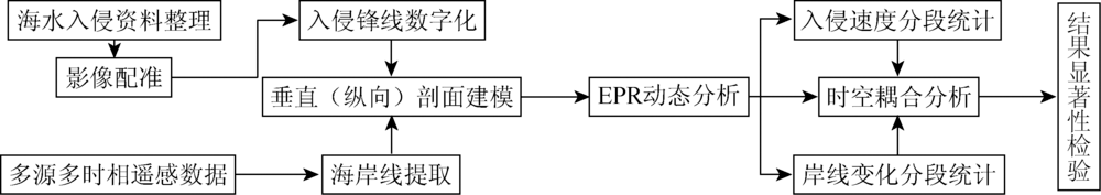
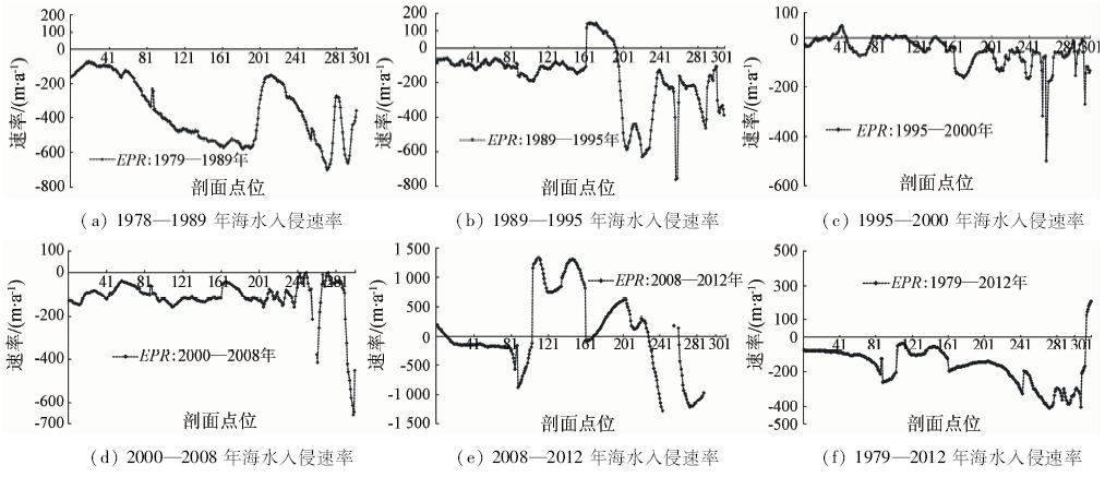
Based on the regional seawater intrusion observation data and the remote sensing integrated observation data, the authors examined spatio-temporal dynamic change characteristics and mode of seawater intrusion and coastline evolution in the south coast zone of Laizhou Bay. Firstly, multi-period remote sensed images were used for monitoring of the regional coastline changes from 1979 to 2012. And then, the temporal and spatial features of seawater intrusion were reconstructed by digital vectorization from the historical filed survey maps. On the basis of above information, the EPR model was introduced and the spatial-temporal coupling mechanism between the seawater intrusion and coastline changes was studied and analyzed. Some conclusions have been reached: ① The regional seawater intrusion experienced a change process from rapid to slow, and the rate of invasion was slowing down after 1990. The front of intrusion line was stable since 1995 and retreated from 2008 to 2012. ② The coastal coastline is dominated by the coastal retreating coastline, besides the local artificial coastline. ③ There is a strong coupling relationship between the change of seawater intrusion frontline and coastline in time and space. The correlation coefficient is 0.407, at the significant level of P less than 0.01 (bilateral). The research results can provide data support and scientific basis for regional seawater intrusion prevention and control.
蒙永辉, 王集宁, 张丽霞, 罗梅. 1979—2012年莱州湾南岸海水入侵与区域海岸线变动时空耦合分析[J]. 国土资源遥感, 2018, 30(3): 189-195.
Yonghui MENG, Jining WANG, Lixia ZHANG, Mei LUO. An analysis of spatial-temporal coupling relationship between seawater intrusion and regional coastline changes in south coast of Laizhou Bay from 1979 to 2012. Remote Sensing for Land & Resources, 2018, 30(3): 189-195.
Gao M S, Luo Y M . Change of groundwater resource and prevention and control of seawater intrusion in coastal zone[J]. Bulletin of Chinese Academy of Sciences, 2016,31(10):1197-1203.
Liu E F, Zhang Z L, Shen J , et al. Origin and characteristics of salt-water intrusion disaster in the downstream of Weihe River on the south coast of Laizhou Bay[J]. Journal of Earth Sciences and Environment, 2004,26(3):78-82,87.
Xue Y Q, WU J C, Xie C H , et al. Sea water intrusion and salt water intrusion in the coastal area of Laizhou Bay[J]. Chinese Science Bulletin, 1998,43(12):983-992.
Zhang Z L, Nie X H, Liu E F , et al. The accumulation records of environmental evolution on the salt-water intruded area south of Laizhou Bay since late Pleistocene[J]. Geographical Research, 2005,24(1):105-112.
Huang L, Guo Z R . Mechanism of sea water intrusion in China's coastal areas and its prevention countermeasures[J]. The Chinese Journal of Geological Hazard and Control, 2008,19(2):118-123.
Chen G Q . Risk Assessment of Seawater Intrusion Disaster in the LaiZhou Bay Based on GIS[D]. Qingdao: Ocean University of China, 2010.
[9]
鲍广扩 . 莱州湾南岸潍坊地区海水入侵评价及自动监测研究[D]. 青岛:山东科技大学, 2014.
Bao G K . Evaluation of Seawater Intrusion and Automatic Monitoring Research in WeiFang Area to the South of LaiZhou Bay[D]. Qingdao:Shandong University of Science and Technology, 2014.
Liu X Z . Environmental setting of sea-water intrusion and its effects on agricultural soil and water environment in Laizhou Bay of Shandong Province[J]. Research of Soil and Water Conservation, 2006,13(6):18-21.
Liu Y J, Cao J R, Gao Y , et al. The driving factors and ecological countermeasures of soil salinization in the seawater intrusion areas in the south of Laizhou Bay[J]. Chinese Agricultural Science Bulletin, 2012,28(2):209-213.
Chen M . The Research of Land Use Change and Its Ecological Effect in Southern Coastal Saltwater-Intruded Area of Laizhou Bay[D]. Jinan:Shandong Normal University, 2009.
Yi H P, Zhang P Y, Bi J S , et al. The influence of seawater intrusion on ecological environment in the eastern coast of Laizhou Bay[J]. Marine Sciences, 2010,34(1):29-34.
[14]
Qi S Z, Qiu Q L . Environmental hazard from saltwater intrusion in the Laizhou Gulf,Shandong Province of China[J]. Natural Hazards, 2011,56(3):563-566.
doi: 10.1007/s11069-010-9686-3
Leng Y Y, Li X H, Liu L . Characteristics and genesis of the natural brine deposit in the north of Weifang,Shandong,China[J]. Journal of Chengdu University of Technology (Science & Technology Edition), 2009,36(2):188-194.
Leading Group Office of Seawater Intrusion in Laizhou Bay Area of Shandong Province Comprehensive Management. Planning of Seawater Intrusion in Laizhou Bay Area of Shandong Province[M]. Beijing: Ocean Press, 1994.
[18]
Zhang Z L, Liu E F, Zhang Y , et al. Environmental evolution in the salt-water intrusion area south of Laizhou Bay since late Pleistocene[J]. Journal of Geographical Sciences, 2008,18(1):37-45.
doi: 10.1007/s11442-008-0037-1
[19]
Wang J N, Meng Y H . Characteristics analysis and model prediction of sea-salt water intrusion in lower reaches of the Weihe River,Shandong Province,China[J]. Journal of Groundwater Science and Engineering, 2016,4(2):149-156.
Li X Y, Jiang W M, Zhang N X . Correlative analysis and tendency prediction of seawater intrusion at southeast coast of Laizhou Bay[J]. The Chinese Journal of Geological Hazard and Control, 1994,5(4):33-39.
Feng A P, Gu D Q, Xia D X . Developments and causes of seawater intrusion in the south coast area of the Laizhou Bay[J]. Coastal Engineering, 2006,25(3):7-13.
Chen G Q, Xu X Y, Peng C S , et al. Assessment of seawater intrusion disaster risk in Laizhou Bay[J]. Journal of Natural Disasters, 2010,19(2):103-112.
Sun Y H, Zhang A D, Wang Q , et al. Influences of human activities on the coastal landform and sea water invasion along the southern Laizhou Bay during the past 30 Years[J]. Marine Geology & Quaternary Geology, 2011,31(5):43-50.
Meng Y H, Fu J, Wang Z C , et al. Characteristics and evaluation of present condition of sea salt water intrusion in northern Weifang city[J]. Shandong Land and Resources, 2014,30(6):62-66.
Liu G Y . Cause and prevention countermeasures on the sea-salted water invasion in Laizhou Bay[J]. The Chinese Journal of Geological Hazard and Control, 2000,11(2):1-4,45.
Li F L . Monitoring and Numerical Simulation of Saltwater Intrusion in the Eastern Coast of Laizhou Bay,China[D]. Qingdao:Ocean University of China, 2005.
Su Q, Yu H J, Xu X Y , et al. Assessment for present status of seawater intrusion into the south coastal area of Laizhou Bay[J]. Coastal Engineering, 2009,28(1):9-14.
Wang J N, Meng Y H, Zhang L X . Remote sensing monitoring and change analysis of yellow river estuary coastline in the past 42 years[J]. Remote Sensing for Land and Resources, 2016,28(3):188-193.doi: 10.6046/gtzyyg.2016.03.29.
[29]
Chander G, Markham B L, Helder D L . Summary of current radiometric calibration coefficients for Landsat MSS,TM,ETM+,and EO-1 ALI sensors[J]. Remote Sensing of Environment, 2009,113(5):893-903.
doi: 10.1016/j.rse.2009.01.007
 2018, Vol. 30