The application of airborne LiDAR technology to landslide survey: A case study of Zhangjiawan Village landslides in Three Gorges Reservoir area
Lei DU1, Jie CHEN1,2, Minmin LI1, Xiongwei ZHENG1, Jing LI1, Zihong GAO1
1.China Aero Geophysical Survey and Remote Sensing Center for Natural Resources, Beijing 100083, China 2.Institute of Remote Sensing and Digital Earth, Chinese Academy of Sciences, Beijing 100101, China
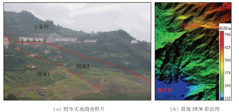
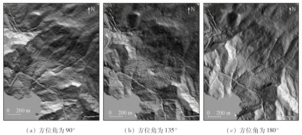
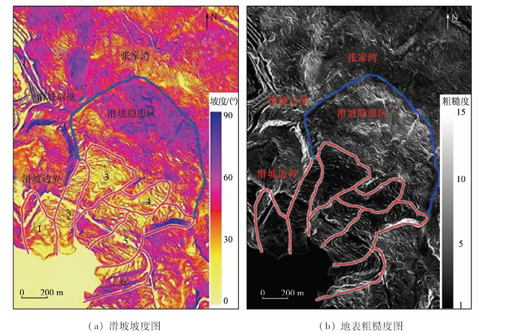
Combined with the positioning and orientation system (POS), the airborne LiDAR system acquires the three dimensional coordinate information of ground objects, and has the capability of fast generation of high-precision digital elevation model (DEM). DEM is a basic map for landslide investigation and monitoring. Its precision can reflect the small ground surface changes directly. The DEM can be used to quantitatively analyze landslide characteristics accurately. There are several advantages of airborne LiDAR technology: it is affected little by weather, it can penetrate the vegetation layer to obtain the ground surface information and its data-processing process is relatively simple. In this paper, the LiDAR technology was applied in Zhangjiawan Village, Zigui County, Hubei Province. The results show that, based on LiDAR technology, landslides can be recognized clearly with slide mountain shadow maps made with high precision DEM and, what is more, quantitative analysis can be carried out to measure landslides characteristics.
杜磊, 陈洁, 李敏敏, 郑雄伟, 李京, 高子弘. 机载激光雷达技术在滑坡调查中的应用——以三峡库区张家湾滑坡为例[J]. 国土资源遥感, 2019, 31(1): 180-186.
Lei DU, Jie CHEN, Minmin LI, Xiongwei ZHENG, Jing LI, Zihong GAO. The application of airborne LiDAR technology to landslide survey: A case study of Zhangjiawan Village landslides in Three Gorges Reservoir area. Remote Sensing for Land & Resources, 2019, 31(1): 180-186.
Ardizzone F, Cardinali M, Galli M , et al. Identification and mapping of recent rainfall induced landslides using elevation data collected by airborne LiDAR[J]. Natural Hazards and Earth System Sciences, 2007,7(6):637-650.
doi: 10.5194/nhess-7-637-2007
[2]
Axelsson P . Processing of laser scanner data-algorithms and applications[J]. ISPRS Journal of photogrammetry and remote Sensing, 1999,54(2-3):138-147.
doi: 10.1016/S0924-2716(99)00008-8
Li X J . Complex Geological Environment Landslide Recognition Based on LiDAR Technology[D]. Wuhan:China University of Geosciences, 2012.
[4]
Glenn N F, Streutker D R, Chadwick D J , et al. Analysis of LiDAR derived topographic information for characterizing and differentiating landslide morphology and activity[J]. Geomorphology, 2006,73(1-2):131-148.
doi: 10.1016/j.geomorph.2005.07.006
National Administration of Surveying, Mapping and Geoinformation of China CH/T 8023—2011 . Airborne Laser Radar Data Processing Technical Specifications[S]. Beijing: China Standard Press, 2011.
Xiao C L, Guo Z C, Zheng X W , et al. Typical applications of airborne LiDAR technique in geological investigation[J]. Remote Sensing for Land and Resources, 2016,28(1):136-143.doi: 10.6046/gtzyyg.2016.01.20.
 2019, Vol. 31