Please wait a minute...
 
国土资源遥感  2019, Vol. 31 Issue (1): 171-179    DOI: 10.6046/gtzyyg.2019.01.23
  技术应用 本期目录 | 过刊浏览 | 高级检索 |
京津高铁沿线地面沉降特征(北京段)
张晓婧1,2, 陈蓓蓓1,2(), 雷坤超3, 陈文锋1,2, 高明亮1,2, 周超凡1,2, 段光耀4
1.三维信息获取与应用教育部重点实验室,北京 100048
2.城市环境过程与数字模拟国家重点实验室培育基地,北京 100048
3.北京市水文地质工程地质大队,北京 100195
4.天津城建大学地质与测绘学院,天津 300384
Characteristics of land subsidence along Beijing-Tianjin inter-city railway (Beijing section)
Xiaojing ZHANG1,2, Beibei CHEN1,2(), Kunchao LEI3, Wenfeng CHEN1,2, Mingliang GAO1,2, Chaofan ZHOU1,2, Guangyao DUAN4
1.Key Lab of 3D Information Acquisition and Application, Ministry of Education, Beijing 100048, China
2.State Key Laboratory Breeding Base of Process of Urban Environment and Digital Simulation, Beijing 100048, China
3.Beijing Institute of Hydrogeology and Engineering Geology, Beijing 100195, China
4.School of Geology and Geomatics, Tianjin Chengjian University, Tianjin 300384, China
全文: PDF(11455 KB)   HTML  
输出: BibTeX | EndNote (RIS)      
摘要 

针对京津高铁(北京段)存在的地面沉降问题,采用时序合成孔径雷达干涉技术获取研究区2010—2015年间地面沉降信息,结合地下水实测数据,采用交叉小波的方法探讨不同层位地下水位变化与地面沉降的关系,最后结合研究区内可压缩黏土层分布情况分析地面沉降与可压缩黏土层厚度的关系。结果表明: 研究区年均沉降速率最大值为121 mm/a; 地面沉降滞后承压水位变化910个月,滞后潜水位变化4个月; 位于同个冲洪积扇控制范围的地面沉降速率随可压缩黏土层厚度的增加而增大。本研究对于科学有效防控不均匀地面沉降对线状地物的损害具有实用意义。

服务
把本文推荐给朋友
加入引用管理器
E-mail Alert
RSS
作者相关文章
张晓婧
陈蓓蓓
雷坤超
陈文锋
高明亮
周超凡
段光耀
关键词 京津高铁地面沉降地下水位滞后性可压缩层    
Abstract

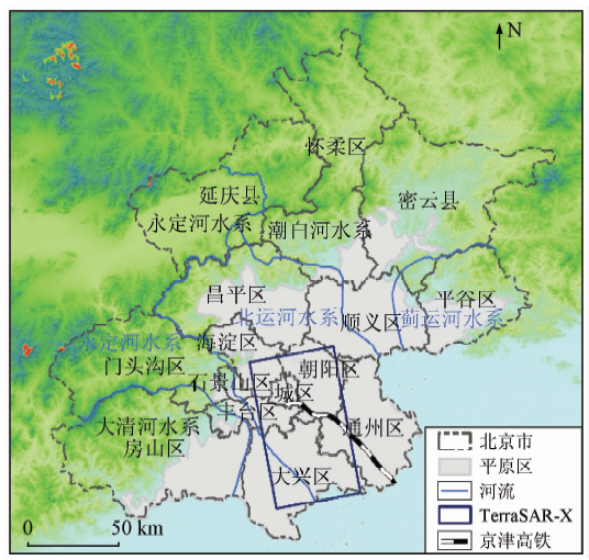
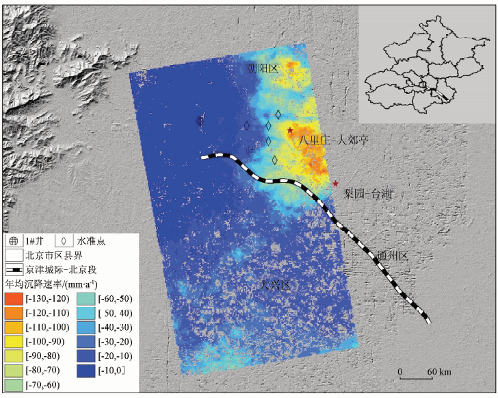
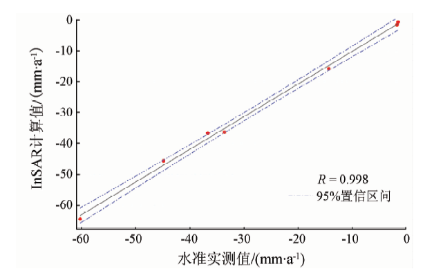
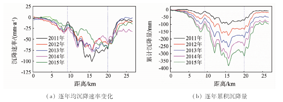
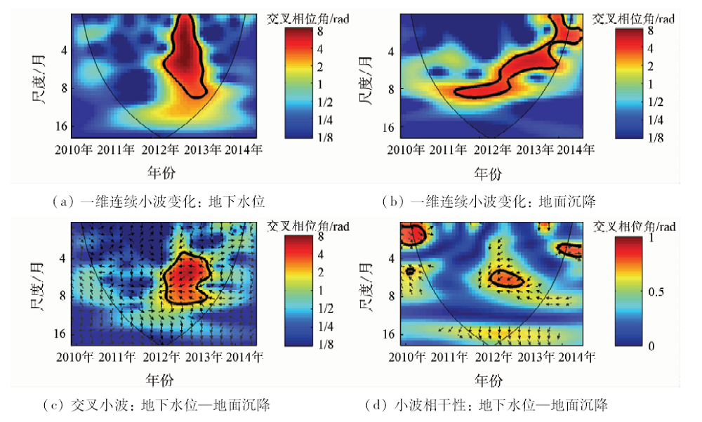
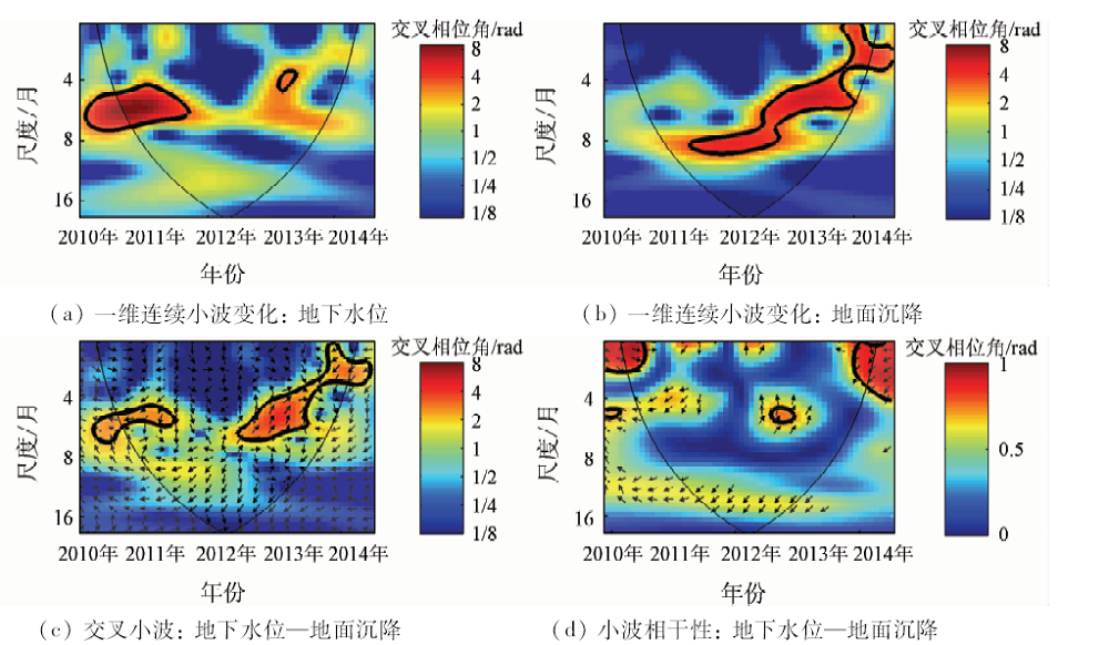
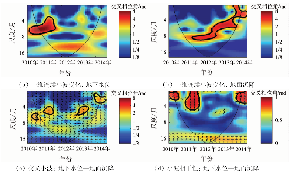
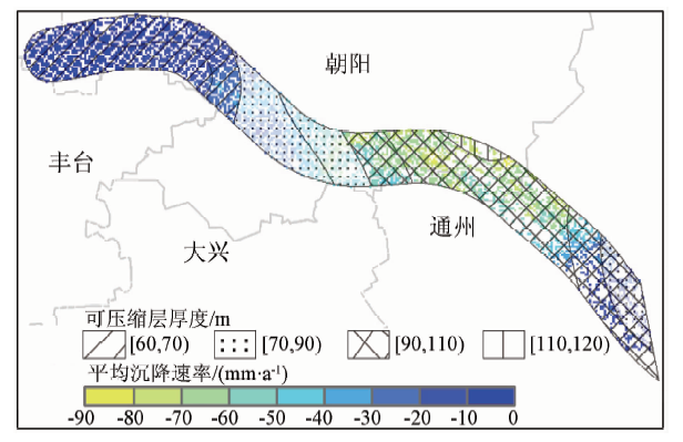
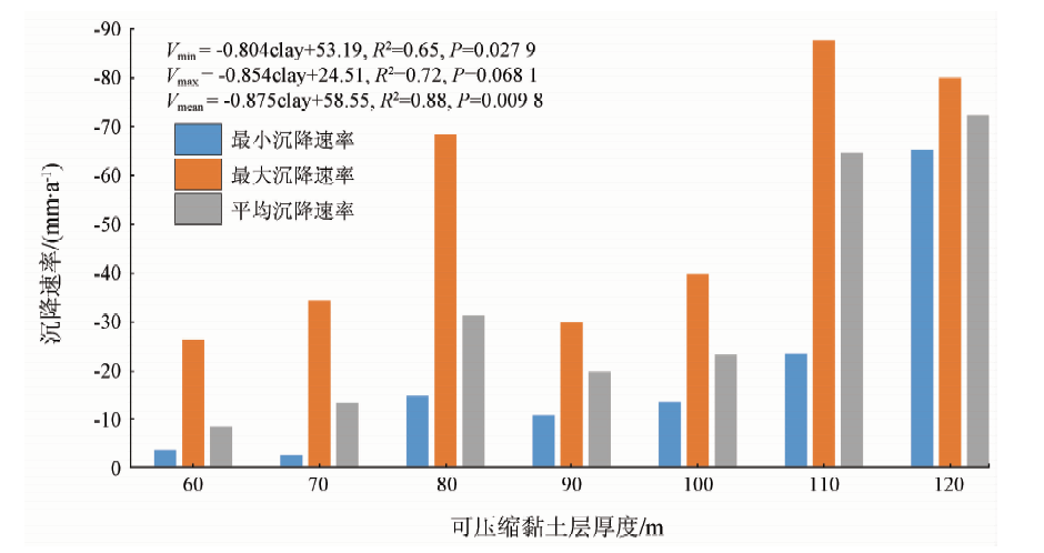
In this paper, according to the land subsidence problem existing in the Beijing-Tianjin inter-city railway (Beijing section), time-series synthetic aperture Radar interferometry was used to obtain the land subsidence information from 2010 to 2015. Combined with the measured data of groundwater, the relationship between the groundwater level changes and the land subsidence at different layers was studied by using the cross wavelet method. Finally, the relationship between land subsidence and compressible clay thickness was analyzed based on the distribution of compressible clay in the study area. The result showed that average annual maximum sedimentation rate in the study area was 121mm/a, that the ground subsidence lagged the pressure level of the pressure level by 910 months, with the lag time of the submersible being 4 months, and that the ground subsidence rate in the control range of the same flushing fan increased with the thickness of compressible clay layer. This research is of great significance for the scientific effective prevention and control of uneven ground settlement on linear ground objects.

Key wordsBeijing Tianjin inter-city railway (BTIR)    land subsidence    groundwater    lagging behind    compressible layer
收稿日期: 2017-09-19      出版日期: 2019-03-14
:  TP79  
基金资助:国家自然科学基金项目"北京地区地面沉降三维形变及演化机理研究"(41130744/D0107);北京市教育委员会科技计划项目"浅地表空间利用差异模式下的地面沉降演化特征"(KM201510028012);天津市自然科学基金项目"基于InSAR技术的京津城际铁路形变监测研究"(16JCZDJC40400)
通讯作者: 陈蓓蓓
作者简介: 张晓婧(1990-),女,硕士研究生,从事地面沉降相关研究。Email: anniweian@163.com。
引用本文:   
张晓婧, 陈蓓蓓, 雷坤超, 陈文锋, 高明亮, 周超凡, 段光耀. 京津高铁沿线地面沉降特征(北京段)[J]. 国土资源遥感, 2019, 31(1): 171-179.
Xiaojing ZHANG, Beibei CHEN, Kunchao LEI, Wenfeng CHEN, Mingliang GAO, Chaofan ZHOU, Guangyao DUAN. Characteristics of land subsidence along Beijing-Tianjin inter-city railway (Beijing section). Remote Sensing for Land & Resources, 2019, 31(1): 171-179.
链接本文:  
https://www.gtzyyg.com/CN/10.6046/gtzyyg.2019.01.23      或      https://www.gtzyyg.com/CN/Y2019/V31/I1/171
Fig.1  研究区位置
Fig.2  京津城际铁路位置水准点的分布及StaMPS获取研究区年均沉降速率
Fig.3  水准测量与InSAR监测结果比较
Fig.4  2011—2015年间京津高铁沿线逐年均沉降速率变化及逐年累积沉降量
年份 2011年 2012年 2013年 2014年 2015年
最大年均沉降速
率/(mm·a-1)
-100.85 -74.10 -79.10 -77.69 -69.85
Tab.1  2011—2015年京津高铁(北京段)各年最大沉降速率
Fig.5  潜水与地面沉降小波变换
Fig.6  第一承压水与地面沉降小波变换
Fig.7  第二承压水与地面沉降小波变换
数据 变换时段 交叉相位角/rad 时间间
隔/月
潜水 2012—2013.5 3.123 9±0.011 9 4.24
第一承压水 2012.5—2013.5 1.093 7±0.706 0 9.41
第二承压水 2011—2011.5 1.566 7±0.412 7 6.35
第二承压水 2012.8—2013.5 0.756 0±0.539 5 10.76
Tab.2  各层地下水与地面沉降信息的交叉相位角及时间间隔
Fig.8  沿线可压缩层厚度分布与PS点叠加
Fig.9  各可压缩层厚度范围内地面沉降统计分析
[1] 汪珊, 张彤, 黄大英 , 等. 北京市地下水合理开发与保护[C]// 地下水开发利用与污染防治技术专刊. 2009: 52-56.
Wang S, Zhang T, Huang D Y , et al. The rational utlization and protection of groundwater in Beijing[C]// Special Issue of Groundwater Development and Utilization and Pollution Control Technology, 2009: 52-56.
[2] Yang Y, Jia S . Situation and countermeasures of prevention & control on land subsidence in Beijing[J]. Urban Geology, 2013,8(4):6-10.
[3] Duan G Y, Gong H L, Liu H H , et al. Monitoring and analysis of land subsidence along Beijing-Tianjin inter-city railway[J]. Journal of the Indian Society of Remote Sensing, 2016,44(6):1-17.
doi: 10.1007/s12524-015-0448-2
[4] 袁怀宇 . 公路工程中沉降板的应用[J]. 东北公路, 2003,26(2):79-80.
Yuan H Y . Settlement plate employing in highway engineering[J]. Northeastern Highway, 2003,26(2):79-80.
[5] 花梅 . 高速铁路路基常用沉降变形监测方法浅析[J]. 铁道标准设计, 2014,58(s1):122-125.
doi: 10.13238/j.issn.1004-2954.2014.S.036
Hua M . Analysis of common settlement deformation monitoring methods for subgrade of high speed railway[J]. Railway Standard Design, 2014,58(s1):122-125.
[6] Tarchi D, Rudolf H, Luzi G, et al. SAR interferometry for structural changes detection:A demonstration test on a dam[C]// Internationl Geoscience and Remote Sensing Symposium.IEEE, 1999.
[7] Ge D Q, Zhang L, Wang Y, et al. Merging multi-track PSI result for land subsidence mapping over very extended area[C]// International Geoscience and Remote Sensing Symposium.IEEE, 2010: 3522-3525.
[8] 冷长明 . 高速铁路地基不均匀沉降的因素及机理分析[J]. 高速铁路技术, 2011,2(3):5-8.
doi: 10.3969/j.issn.1674-8247.2011.03.002
Leng C M . Analysis of the factor and mechanism of uneven settlement of high-speed raiway subgrade[J]. High Speed Railway Technology, 2011,2(3):5-8.
[9] 高亮, 赵磊, 曲村 , 等. 路基上CRTSⅢ型板式无砟轨道设计方案比较分析[J]. 同济大学学报(自然科学版), 2013,41(6):848-855.
doi: 10.3969/j.issn.0253-374x.2013.06.008
Gao L, Zhao L, Qu C , et al. Analysis on design scheme of CRTSⅢ slab track structure on road[J]. Journal of Tongji University (Natural Science), 2013,41(6):848-855.
[10] 刘晓龙, 张永红, 李英会 , 等, 基于时间序列TerraSAR-X影像的线状地物沉降监测试验研究[J]. 遥感信息, 2013,28(4):57-62.
doi: 10.3969/j.issn.1000-3177.2013.04.010
Liu X L, Zhang Y H, Li Y H , et al. Exploration of subsidence along linear engineering structures on time series of TerraSAR-X images[J]. Remote Sensing Information, 2013,28(4):57-62.
[11] 王荣, 杨艳, 田芳 , 等. 高速铁路区域地面沉降监测体系构建[J]. 上海国土资源, 2014,35(2):17-20.
doi: 10.3969/j.issn.2095-1329.2014.02.005
Wang R, Yang Y, Tian F , et al. Construction of a monitoring system for regional land subsidence affecting high-speed railways[J]. Shanghai Land and Resources, 2014,35(2):17-20.
[12] 贾三满, 王海刚, 赵守生 , 等. 北京地面沉降机理研究初探[J]. 城市地质, 2007,2(1):20-26.
doi: 10.3969/j.issn.1007-1903.2007.01.005
Jia S M, Wang H G, Zhao S H , et al. A tentative study of the mechanism of land subsidence in Beijing[J]. City Geology, 2007,2(1):20-26.
[13] 陈蓓蓓 . 北京市典型地区地面沉降演化过程与机理分析[M]. 北京: 中国环境出版社, 2015.
Chen B B. The Evolution Process and Mechanism of Land Subsidence in Typical Area,Beijing[M]. Beijing: China Environmental Science Press, 2015.
[14] Hooper A J . Persistent Scatter Radar Interferometry for Crustal Deformation Studies and Modeling of Volcanic Deformation[D]. Stanford:Stanford University, 2006.
[15] 刘一霖, 张勤, 黄海军 , 等. 矿区地表大量级沉陷形变短基线集InSAR监测分析[J]. 国土资源遥感, 2017,29(2):144-151.doi: 10.6046/gtzyyg.2017.02.21.
doi: 10.6046/gtzyyg.2017.02.21
Liu Y L, Zhang Q, Huang H J , et al. Monitoring and analysis large scale land subsidence over the mining area using small baseline subset InSAR[J]. Remote Sensing for Land and Resources, 2017,29(2):144-151.doi: 10.6046/gtzyyg.2017.02.21.
[16] 刘志敏, 李永生, 张景发 , 等. 基于SBAS-InSAR的长治矿区地表形变监测[J]. 国土资源遥感, 2014,26(3):37-42.doi: 10.6046/gtzyyg.2014.03.06.
doi: 10.6046/gtzyyg.2014.03.06
Liu Z M, Li Y S, Zhang J F et al. An analysis of surface deformation in the Changzhi mining area using small baseline InSAR[J]. Remote Sensing for Land and Resources, 2014,26(3):37-42.doi: 10.6046/gtzyyg.2014.03.06.
[17] 王文圣, 丁晶, 向红莲 . 小波分析在水文学中的应用研究及展望[J]. 水科学进展, 2002,13(4):515-520.
doi: 10.3321/j.issn:1001-6791.2002.04.021
Wang W S, Ding J, Xiang H L . Application and prospect of wavelet analysis in hydrology[J]. Advances in Water Science, 2002,13(4):515-520.
[18] 郭良迁, 薄万举, 杨国华 . 华北地区断裂带的现代形变特征[J]. 大地测量与地球动力学, 2003,23(2):29-36.
doi: 10.3969/j.issn.1671-5942.2003.02.005
Guo L Q, Bo W J, Yang G H . Characteristics of current deformation of fault beltisin north China[J]. Journal of Geodesy and Geodynamics, 2003,23(2):29-36.
[19] 林健 . 北京市城近郊区地下水污染演变分析研究[D]. 长春:吉林大学, 2004.
Lin J . The Analysis of Pollution History for the Groundwater in Urban and Suburb Area of Beijing[D]. Changchun: Jilin University, 2004.
[20] 罗勇 . 北京地面沉降发展新趋势初步分析[J]. 上海国土资源, 2017,38(2):13-17.
doi: 10.3969/j.issn.2095-1329.2017.02.004
Luo Y . Research on the new trends of Beijing land subsidence[J]. Shanghai Land and Resources, 2017,38(2):13-17.
[21] Grinsted A, Moore J C, Jevrejeva S . Application of the cross wavelet transform and wavelet coherence to geophysical time series[J]. Nonlinear Processes in Geophysics, 2004,11(5/6):561-566.
doi: 10.5194/npg-11-561-2004
[22] 姜媛, 杨艳, 王海刚 , 等. 北京平原区地面沉降的控制与影响因素[J]. 上海国土资源, 2014,26(4):130-133.
doi: 10.3969/j.issn.2095-1329.2014.04.031
Jiang Y, Yang Y, Wang H G , et al. Factors controlling land subsidence on the Beijing plain[J]. Shanghai Land and Resources. 2014,26(4):130-133.
[1] 周超凡, 宫辉力, 陈蓓蓓, 雷坤超, 施轹原, 赵宇. 联合WT-RF的津保高铁沿线地面沉降预测[J]. 自然资源遥感, 2021, 33(4): 34-42.
[2] 史珉, 宫辉力, 陈蓓蓓, 高明亮, 张舜康. Sentinel-1A京津冀平原区2016—2018年地面沉降InSAR监测[J]. 自然资源遥感, 2021, 33(4): 55-63.
[3] 于海若, 宫辉力, 陈蓓蓓, 周超凡. 新水情下利用InSAR-GRACE卫星的新兴风险预警与城市地下空间安全展望[J]. 国土资源遥感, 2020, 32(4): 16-22.
[4] 汪宝存, 朱琳, 潘登, 郭凌飞, 彭鹏. 郑州市地面沉降时空演变规律研究[J]. 国土资源遥感, 2020, 32(3): 143-148.
[5] 朱茂, 沈体雁, 黄松, 白书建, 葛春青, 胡琼. InSAR技术地铁沿线建筑物形变监测[J]. 国土资源遥感, 2019, 31(2): 196-203.
[6] 范景辉, 王如意, 赵红丽, 李雁明, 林昊, 燕云鹏. 地面沉降光栅立体图研究制作[J]. 国土资源遥感, 2018, 30(4): 102-107.
[7] 张晓博, 赵学胜, 葛大庆, 刘斌, 张玲, 李曼, 王艳. 基于Sentinel TOPS模式Stacking技术监测淮南矿区沉降[J]. 国土资源遥感, 2018, 30(4): 200-205.
[8] 戴晨曦, 谢相建, 徐志刚, 杜培军. 中草药材种植遥感监测与分析——以云南省文山和红河地区三七种植为例[J]. 国土资源遥感, 2018, 30(1): 210-216.
[9] 陈继伟, 曾琪明, 焦健, 赵斌臣. Sentinel-1A卫星TOPS模式数据的SBAS时序分析方法——以黄河三角洲地区为例[J]. 国土资源遥感, 2017, 29(4): 82-87.
[10] 李曼, 葛大庆, 张玲, 刘斌, 郭小方, 王艳. 基于PSInSAR技术的曹妃甸新区地面沉降发育特征及其影响因素分析[J]. 国土资源遥感, 2016, 28(4): 119-126.
[11] 孙晓鹏, 鲁小丫, 文学虎, 甄艳, 王蕾. 基于SBAS-InSAR的成都平原地面沉降监测[J]. 国土资源遥感, 2016, 28(3): 123-129.
[12] 杨成生, 刘媛媛, 敖萌. 基于SBAS时序分析的大同地面沉降与地下水活动研究[J]. 国土资源遥感, 2015, 27(1): 127-132.
[13] 王艳, 张玲, 葛大庆, 张学东, 李曼. 升降轨PSInSAR观测反演沉降与水平向位移试验[J]. 国土资源遥感, 2014, 26(4): 97-102.
[14] 葛大庆, 殷跃平, 王艳, 张玲, 郭小方, 王毅. 地面沉降-回弹及地下水位波动的InSAR长时序监测——以德州市为例[J]. 国土资源遥感, 2014, 26(1): 103-109.
[15] 范景辉, 李梅, 郭小方, 葛大庆, 刘圣伟, 刘广, 郭华东. 基于PSInSAR方法和ASAR数据监测天津地面沉降的试验研究[J]. 国土资源遥感, 2007, 19(4): 23-27.
Viewed
Full text


Abstract

Cited

  Shared   
  Discussed   
京ICP备05055290号-2
版权所有 © 2015 《自然资源遥感》编辑部
地址:北京学院路31号中国国土资源航空物探遥感中心 邮编:100083
电话:010-62060291/62060292 E-mail:zrzyyg@163.com
本系统由北京玛格泰克科技发展有限公司设计开发