1. China Aero Geophysical Survey and Remote Sensing Center for Natural Resources, Beijing 100083, China 2. Key Laboratory of Airborne Geophysics and Remote Sensing Geology, Ministry of Natural Resources, Beijing 100083, China
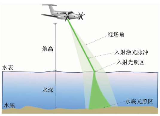
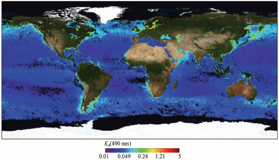
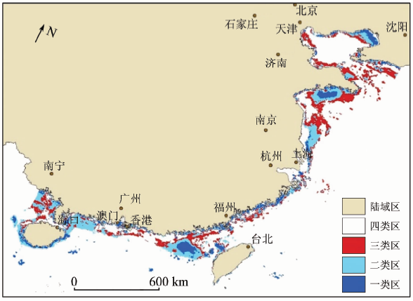
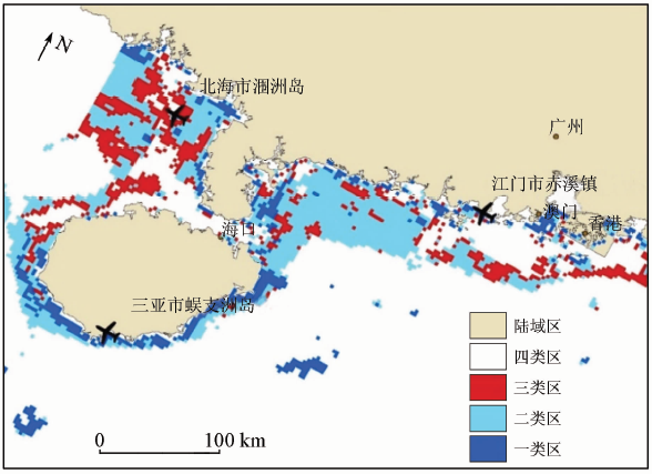
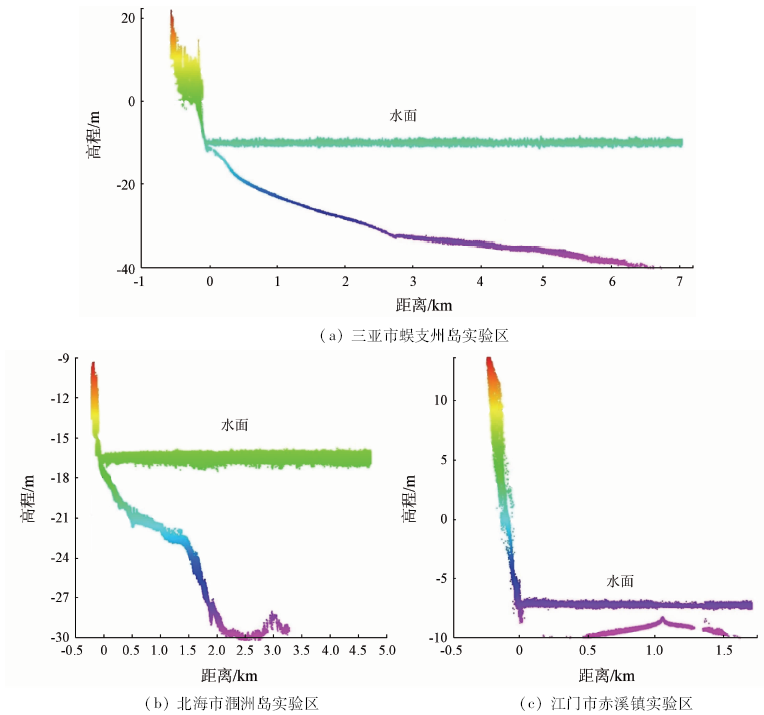
Water transparency is the key factor of airborne LiDAR bathymetry. Turbid waters produce noise in LiDAR echo signal and weaken the laser pulse or cause a gap. Therefore, it is necessary to study water optical properties. Using MODIS Kd (490 nm) and general bathymetric chart of the oceans (GEBCO) bathymetric data, the authors calculated the maximum detectable depth in China’s coastal area based on CZMIL Nova, and classified the result into 3 types. CZMIL test data from different areas were used to verify the accuracy of the classification. The results show that a total of 211,900 km 2 sea area is suitable for the performance of bathymetric survey with airborne LiDAR. The coastal area of Wenchang to Dongfang of Hainan, Beihai and the east and west of Leizhou peninsula, Rizhao to Qindao of Shangdong and Yinzhou to Suizhong of Liaodong Bay are suitable for the performance of land and sea integrating topographic survey, with the maximum measurable depths estimated by Kd being 20~40 m, 10~20 m, 20~25 m, 10~15 m, respectively.
Yang J, Zhang R D, Weng S C , et al. The assessment method of coastal environmental carrying capacity[J]. China Environmental Science, 2013,33(s1):178-185.
Wen W . Research on Underwater Continuous Laser Backscattering Measurement Method Based on Correlation Characteristics[D]. Harbin:Harbin Engineering University, 2007
[3]
Feygels V, Ramnath V, Smith B , et al. Meeting the international hydrographic organization requirements for bottom feature detection using the coastal zone mapping and imaging LiDAR (CZMIL)[C]// Oceans.IEEE, 2016.
Ding K, Li Q Q, Zhu J S , et al. Evaluation of airborne LiDAR bathymetric parameters on the northern South China Sea based on MODIS data[J]. Acta Geodaetica et Cartographica Sinica, 2018,47(2):180-187.
Li K, Tong X C, Zhang Y S , et al. Inversion of diffuse attenuation coefficient spectral in the Yellow Sea/East China Sea and evaluation of laser bathymetric performance[J]. Journal of Remote Sensing, 2015,19(5):761-769.
Ding K, Li Q Q, Zhu J S , et al. Analysis of diffuse attenuation coefficient spectra of coastal waters of Hainan Island and performance estimation of airborne LiDAR bathymetry[J]. Spectroscopy and Spectral Analysis, 2018,38(5):1582-1587.
[9]
Muirhead K, Cracknell A P . Airborne LiDAR bathymetry[J]. International Journal of Remote Sensing, 1986,7(5):597-614.
[10]
Sizgoric S, Banic J, LaRocque P . The history of laser bathymetry[M]// Lampropoulos G A,Chrostowski J,Measures R M.Applications of Photonic Technology.Boston:Springer, 1995: 207-217.
[11]
Fernandez-Diaz J C, Glennie C L, Carter W E , et al. Early results of simultaneous terrain and shallow water bathymetry mapping using a single-wavelength airborne LiDAR sensor[J]. IEEE Journal of Selected Topics in Applied Earth Observations and Remote Sensing, 2014,7(2):623-635.
Qing H M, Wang C, Xi X H , et al. Development of airborne laser bathymetric technology and applications[J]. Remote Sensing Technology and Application, 2016,31(4):617-624.
[13]
Feygels V I, Park J Y, Wozencraft J , et al. CZMIL(coastal zone mapping and imaging LiDAR):From first flights to first mission through system validation[C]// Ocean Sensing and Monitoring V, 2013.
[14]
Aitken J, Ramnath V, Feygels V , et al. Prelude to CZMIL:Seafloor imaging and classification results achieved with CHARTS and the rapid environmental assessment (REA) processor[J]. Proceedings of SPIE-the International Society for Optical Engineering, 2010.
[15]
Feygels V, Ramnath V, Marthouse R , et al. CZMIL as a rapid environmental disaster response tool[C]// Oceans.Aberdeen:IEEE, 2017.
[16]
Gordon H R, Smith R C, Zaneveld J R V . Introduction to ocean optics[C]// Ocean Optics VII, 1980,208:14-55.
[17]
Austin R W, Petzold T J . Spectral dependence of the diffuse attenuation coefficient of light in ocean waters[C]// Ocean Optics VII, 1984,489:168.
Zhao W J, Chao W X, Hu S B , et al. Comparison of diffuse attenuation coefficient of downwelling irradiance products derived from MODIS-Aqua in the South China Sea[J]. Optics and Precision Engineering, 2018,26(1):14-24.
[19]
Werdell P J, Bailey S W . An improved in-situ bio-optical data set for ocean color algorithm development and satellite data product validation[J]. Remote Sensing of Environment, 2005,98(1):122-140.
 2020, Vol. 32