Application of the theory of structural hierarchy to the remote sensing geology
Jianyu LIU1,2, Ling CHEN2(), Wei LI2, Genhou WANG1, Bo WANG1
1. School of Earth Sciences and Resources, China University of Geoscience, Beijing 100083, China 2. China Aero Geophysical Survey and Remote Sensing Center for Natural Resources, Beijing 100083, China
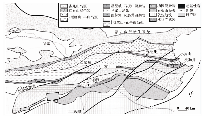
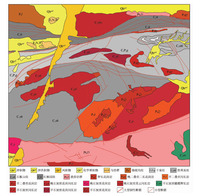
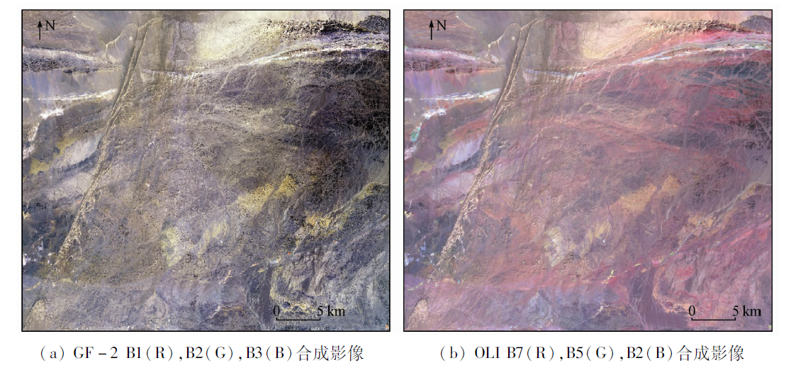
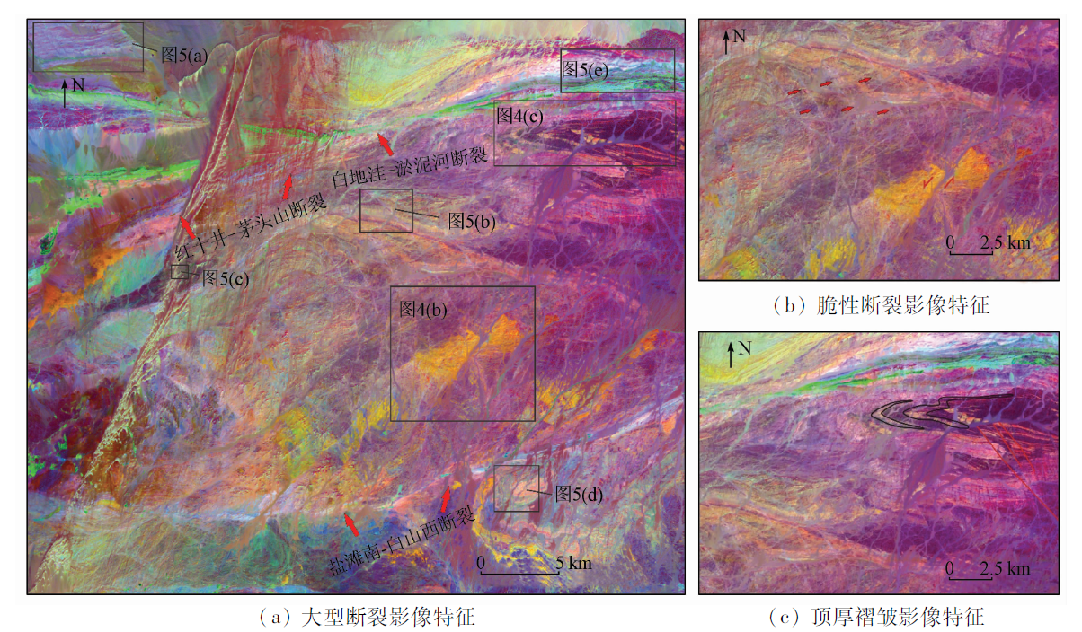
It is difficult to identify the relative ages of lithological units only relying on remote sensing images with few reference data. In case of lack of geological references and difficult fieldwork, it is limited to use remote sensing images for interpretation. To solve these problems, the authors firstly introduced the theory of structural hierarchy to geological interpretation and presented a new method to classify the regional structures and small-scale structures extracted from OLI and GF-2 data respectively. To some extent, this method can determine the relative ages of the lithological units, the events of tectonic evolution and the advantageous areas for metallogenesis in the areas with only a few geological reference data. And it provides a new way for exploiting the advantages of high ground resolution of GF-2 so as to promote the development of remote sensing geology in foreign areas.
刘建宇, 陈玲, 李伟, 王根厚, 王博. 浅析构造层次理论在遥感地质工作中的应用[J]. 国土资源遥感, 2019, 31(3): 166-173.
Jianyu LIU, Ling CHEN, Wei LI, Genhou WANG, Bo WANG. Application of the theory of structural hierarchy to the remote sensing geology. Remote Sensing for Land & Resources, 2019, 31(3): 166-173.
Liu L, Zhou J, Han L , et al. Mineral mapping and ore prospecting using Landsat TM and Hyperion data,Wushitala,Xinjiang,northwestern China[J]. Ore Geology Reviews, 2017,81:280-295.
[2]
Zhang T, Yi G, Li H , et al. Integrating data of Aster and Landsat-8 OLI (AO) for hydrothermal alteration mineral mapping in duolong porphyry Cu-Au deposit,Tibetan plateau,China[J]. Remote Sensing, 2016,8(12):890.
[3]
Pour A B, Hashim M, Hong K J , et al. Lithological and alteration mineral mapping in poorly exposed lithologies using Landsat-8 and ASTER satellite data:North-eastern Graham Land,Antarctic Peninsula[J]. Ore Geology Reviews, 2019,108:112-133.
Liu X X, Chen J P, Zeng M , et al. Geological structural interpretation of Qiangduo area in Tibet based on multi-source remote sensing data[J]. Remote Sensing for Land and Resources, 2015,27(3):154-160.doi: 10.6046/gtzyyg.2015.03.24.
Zhang N N, Zhou K F . Research on identification methods of porphyry alteration zones based on ASTER data[J]. Chinese Journal of Geology, 2016,51(3):990-1001.
Ren G L, Yang J L, Yang M , et al. Application of hyperspectral remote sensing anomaly information on metallogenic prediction in the Jintanzi-Mingjingou area of Beishan,Gansu[J]. Geotectonica Et Metallogenia, 2013,37(4):765-776.
[7]
马托埃, 孙坦, 张道安 . 地壳变形[M].地质出版社, 1984.
Mattauer M, Sun T, Zhang D A. Crust Deformation[M].Geological Publishing House. 1984.
[8]
Xiao W J, Mao Q G, Windley B F , et al. Paleozoic multiple accretionary and collisional processes of the Beishan orogenic collage[J]. American Journal of Science, 2010,310(10):1553-1594.
[9]
新疆地质矿产局. 白山幅1/20万区域调查报告[R]. 乌鲁木齐:新疆地质矿产局, 1979.
Xinjiang Bureau of Geology and Mineral Resources . The Report of Regional Geology Survey in Baishan Region(1:200 000)[R]. Urumqi:Xinjiang Bureau of Geology and Mineral Resources, 1979.
[10]
新疆地质矿产局. 白玉山幅1/20万区域调查报告[R]. 乌鲁木齐:新疆地质矿产局, 1979.
Xinjiang Bureau of Geology and Mineral Resources. The Report of Regional Geology Survey in Baiyushan Region(1:200 000)[R]. Urumqi:Xinjiang Bureau of Geology and Mineral Resources, 1979.
Ding J H, Xing S W, Xiao K Y , et al. Geological characteristics and resource potential analysis of the Dongtianshan-Beishan Cu-Ni-Au-Pb-Zn metallogenic betls[J]. Acta Geologica Sinica, 2016,90(7):1392-1412.
Wang Z Z, An G B . Ore controlling factors and minerogenic prognosis of western metallogenic belt of south belt of Beishan,Gansu[J]. Xinjiang Geology, 2007,25(3):307-312.
He G, Gu X X, Zhang Y M , et al. Geological characteristics and genesis of the Mount Daqing gold deposit in Beishan area,Xinjiang[J].Mineral Deposits, 2014(S1):89-90.
Chen B L, Yang N, Wu G G , et al. Analysis of ore-controlling structure in ductile shear zone type gold deposits in southern Beishan area,Gansu Province[J]. Mineral Deposits, 2002,21:149-158.
[16]
Khan S D, Mahmood K . The application of remote sensing techniques to the study of ophiolites[J]. Earth-Science Reviews, 2008,89(3-4):135-143.
[17]
Kumar C, Shetty A, Raval S , et al. Lithological discrimination and mapping using ASTER SWIR data in the Udaipur area of Rajasthan,India[J]. Procedia Earth and Planetary Science, 2015,11:180-188.
[18]
Rajendran S, Al-Khirbash S, Pracejus B , et al. ASTER detection of chromite bearing mineralized zones in Semail Ophiolite Massifs of the northern Oman Mountains:Exploration strategy[J]. Ore Geology Reviews, 2012,44:121-135.
Chen B L . A discussion on origin of Jinwozi ductile shear zone type gold deposit in Beishan area of Gansu and Xinjiang[J]. Mineral Deposits, 2010,29(6):972-982.
Liu J Y, Chen L, Li W , et al. An improved method for extracting alteration related to the ductile shear zone type gold deposits using ASTER data[J]. Remote Sensing for Land and Resources, 2019,31(1):229-236.doi: 10.6046/gtzyyg.2019.01.30.
Xiao C C, Dong L N, Chen W R , et al. The capability of domestic satellites’ overseas geological service based on multiple factor analysis[J]. Remote Sensing for Land and Resources, 2017,29(s1):8-12.doi: 10.6046/gtzyyg.2017.s1.02.
 2019, Vol. 31
  ), 李伟2, 王根厚1, 王博1