1.College of Land Science and Technology, China Agricultural University, Beijing 100193, China 2.China Institute of Land Survey and Planning, Beijing 100035, China
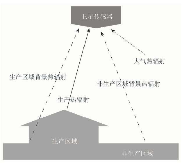
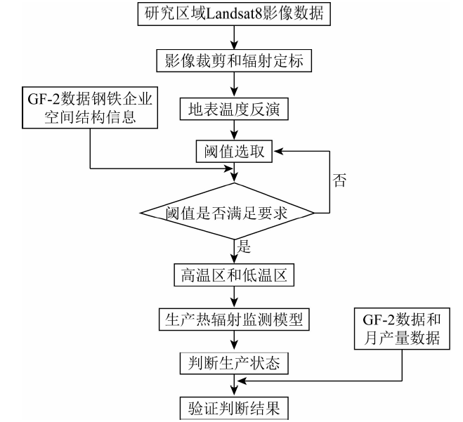
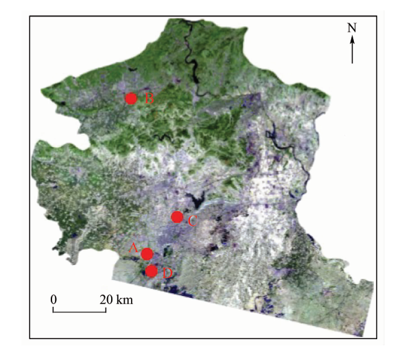
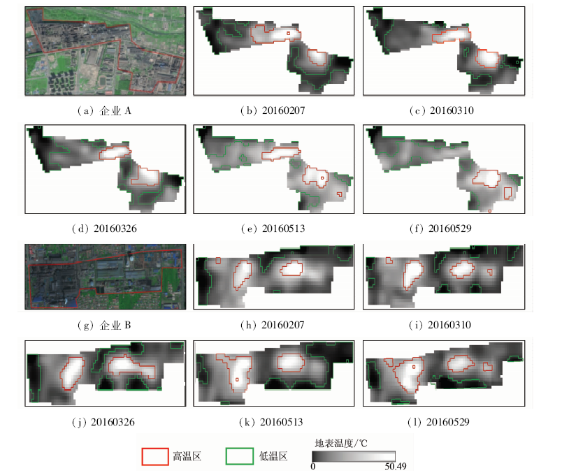
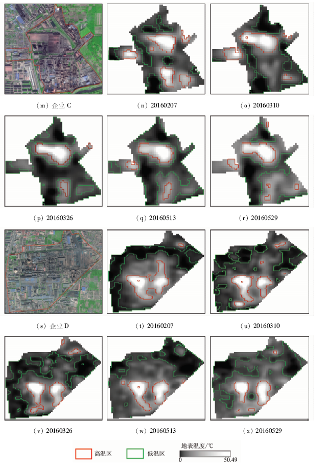
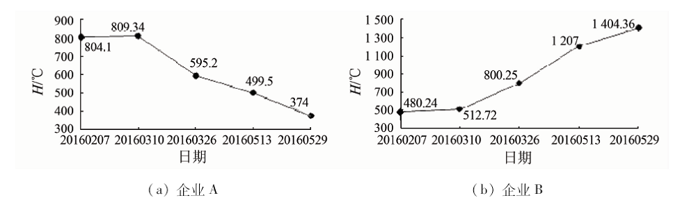
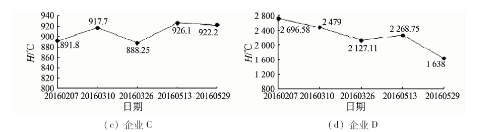
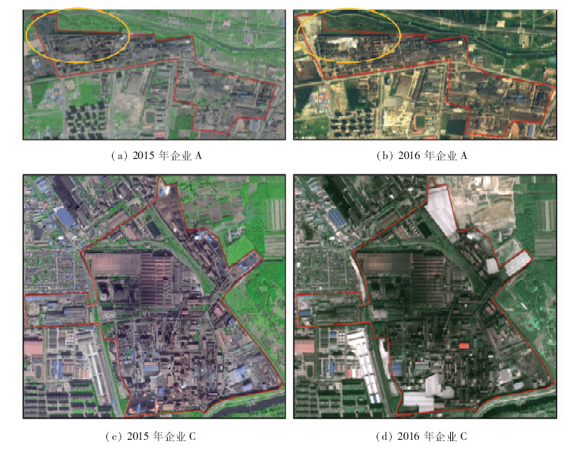
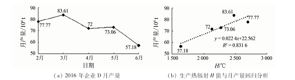
In order to monitor production state of iron and steel enterprises with auxiliary, the authors took Tangshan iron and steel enterprises as study cases to obtain the land surface temperature in tenth band of TIRS inversion derived from Landsat8 data on February 7, March 10, March 26, May 13 and May 29, 2016,in combination with the spatial structure of iron and steel enterprise information provided by GF-2 data from September 26, 2015 and September 10, 2016. The land surface temperature was finally divided into low temperature region (mainly non-production area) and high temperature region (mainly production area) by using threshold. On such a basis, the authors established production thermal radiation model to determine the production status of iron and steel enterprises in this period. Finally, the results obtained by the authors were preliminarily validated by the spatial structure change information provided by GF-2 satellite data and monthly output data of iron and steel enterprises. The results show that it is feasible to evaluate the production status of iron and steel enterprises by using thermal radiation model of production based on thermal infrared remote sensing.
李静, 孙强强, 张平, 孙丹峰, 温礼, 李宪文. 基于多时相热红外遥感的钢铁企业生产状态辅助监测[J]. 国土资源遥感, 2019, 31(1): 220-228.
Jing LI, Qiangqiang SUN, Ping ZHANG, Danfeng SUN, Li WEN, Xianwen LI. A study of auxiliary monitoring in iron and steel plant based on multi-temporal thermal infrared remote sensing. Remote Sensing for Land & Resources, 2019, 31(1): 220-228.
Huang D, Chen L Y, Zhang L F . 2015 China steel industry energy saving and environmental protection progress analysis[J]. China steel industry, 2016(7):14-18.
[2]
勾艳辉 . 产能过剩所致失业人员再就业路径分析[D]. 大连:东北财经大学, 2016.
Gou Y H . Path Analysis of Reemployment of Unemployed People Caused by Excess Capacity[D]. Dalian:Dongbei University of Finance and Economics, 2016.
The development research center of the State Council,"the long term mechanism for resolving excess production capacity", Zhou J Q . Reform and development:Two key aspects of structural adjustment of iron and steel supply side[J]. State Administration, 2016(20):41-48.
[4]
王金友 . 钢铁企业环境自动监测系统的设计与研究[D]. 上海:复旦大学, 2008.
Wang J Y . Design and Research of Automatic Environmental Monitoring System for Iron and Steel Enterprises[D]. Shanghai:Fudan University, 2008.
Benkan. Backward production capacity assessment team to check on the elimination of backward production capacity[J]. Xinjiang Iron and Steel Out of State, 2015(2):33-33.
Zhang Y, Yu T, Gu X F , et al. Application of CBERS-02 IRMSS thermal infrared data to land surface temperature retrieval and its application in quantitative analysis of urban heat island effect[J]. Journal of Remote Sensing, 2006,10(5):789-797.
Kan Z H, Liu Z S, Li Z J . Retrieval of land surface temperature and analysis of heat island effect in Taihu based on Landsat-8 thermal infrared data[J]. Journal of East China Normal University (Natural Science Edttion), 2016(4):129-138.
[8]
Lo C P, Quattrochi D A, Luvall J C . Application of high-resolution thermal infrared remote sensing and GIS to assess the urban heat island effect[J]. International Journal of Remote Sensing, 1997,18(2):287-304.
doi: 10.1080/014311697219079
[9]
Han Q . Study on urban heat island effect with HJ-1B thermal infrared remote sensing image[J]. Spacecraft Recovery and Remote Sensing, 2012.
Lyu Y L, Mao Y P, Shi Z T . Thermal infrared remote sensing applied to earthquake monitoring and prediction.[J]. Science and Technology Review, 2009,27(6):91-96.
Zhang G, Zhan F, Ma H . Application of thermal infrared remote sensing in forest fire prevention work[J]. Henan Science and Technology, 2014(13):182-182.
[13]
Kuenzer C, Dech S . Thermal infrared remote sensing:Sensors,methods,applications[J]. Photogrammetric Engineering and Remote Sensing, 2015,81(5):359-360.
doi: 10.1016/S0099-1112(15)30104-X
Pang W Z . The latest development of infrared thermal imaging technology and security application analysis[J]. A&s:Security & Automation, 2010(12):144-146.
Wen S Y . A study on the brightness temperature background field foundation and the method for extracting anomalies of thermal infrared in the seismotectonic area[D]. Shandong:China University of Petroleum, 2011.
Xu H Q, Huang S L . Determination of the accuracy of Landsat 8 TIRS thermal infrared spectroscopy data[J]. Spectroscopy and Spectral Analysis, 2016,36(6):1941-1948.
Yang X S . Retrieval of Land Surface Temperature from Landsat8 Satellite Data Based on Single Channel Algorithm[D]. Beijing:China University of Geosciences(Beijing), 2015.
Yang Z Y, Zhang G S, Wang X . Land use classification based on Landsat8 remote sensing images:A case study of Xi’an City,Shaanxi Province[J]. Natural Science(Abstract), 2016(2):147-148.
[19]
Rozenstein O, Qin Z, Derimian Y , et al. Derivation of land surface temperature for Landsat-8 TIRS using a split window algorithm.[J]. Sensors, 2014,14(4):5768.
doi: 10.3390/s140405768
pmid: 4029672
[20]
Wang F, Qin Z, Song C , et al. An improved mono-window algorithm for land surface temperature retrieval from Landsat 8 thermal infrared sensor data[J]. Remote Sensing, 2015,7(4):4268-4289.
doi: 10.3390/rs70404268
Li X W, Niu Z C, Jiang S , et al. Application of Landsat 8 satellite OLI remote sensing images in ecological environment monitoring[J]. Environmental Monitoring and Warning, 2013,5(6):1-5.
Cui E H, Wu J D, Gao J . High score two opens the era of high resolution remote sensing satellite applications in China[J]. Space Exploration, 2014(10):6-9.
Liang S N, Wei H Y, Gan F P , et al. Preliminary application evaluation of high resolution two satellite data in remote sensing geological survey[J]. Space Flight Back and Remote Sensing, 2015,36(4):63-72.
Liu X J, Liang S N, Wu X J , et al. Identification of landslide hazard by remote sensing data of high resolution two satellite data:A case study of Yunnan,Dongchuan[J]. Space Flight Back and Remote Sensing, 2015,36(4):93-100.
Wu X J, Xiao C C, Cui Z Y , et al. "High vibration camp,No.two"coast satellite data object extraction method returns[J]. Space and Remote Sensing, 2015,36(4):84-92.
[26]
Li Z L, Tang B H, Wu H , et al. Satellite-derived land surface temperature:Current status and perspectives[J]. Remote Sensing of Environment, 2013,131(131):14-37.
doi: 10.1016/j.rse.2012.12.008
Song T, Duan Z, Liu J Z , et al. Landsat 8 surface temperature inversion algorithm comparison data[J]. Journal of Remote Sensing, 2015,19(3):451-464.
[29]
Krofcheck D, Eitel J, Lippitt C , et al. Remote sensing based simple models of GPP in both disturbed and undisturbed piñon-juniper woodlands in the southwestern U.S.[J]. Remote Sensing, 2015,8(1):20.
doi: 10.3390/rs8010020
Yan L L, Qu C Y, Wen S Y , et al. A comparison study on annual variation of thermal infrared brigtness temperature from meteorological stations[J]. Acta Seismologica Sinica, 2012,34(2):257-266.
Gao W S, Zhang Y Z, Fang S F , et al. A fast estimation method of atmospheric parameters for Landsat-8 TIRS data[J]. Journal of Geo-information Science, 2017,19(1):110-116.
[33]
Nikam B R, Ibragimov F, Chouksey A , et al. Retrieval of land surface temperature from Landsat 8 TIRS for the command area of Mula irrigation project[J]. Environmental Earth Sciences, 2016,75(16):1169.
doi: 10.1007/s12665-016-5952-3
Xu H Q . Retrieval of reflectance and land surface temperature of the newly-launched Landsat8 satellite[J]. Journal of Geophysics, 2015,58(3):741-747.
[35]
Nichol G, Thomas E, Callaway C W , et al. Regional variation in out-of-hospital cardiac arrest incidence and outcome[J]. JAMA. 2008,300(12):1423-1431.
doi: 10.1001/jama.300.12.1423
Xu B, Niu Y X, Deng C Y , et al. Algorithm of global mean and standard deviation for motion blur parameters identification[J]. Optical Technique, 2015,41(4):341-345.
[37]
王国定 . 平均数指数和平均指标指数的比较[J]. 中国统计, 1998(8):29-30.
Wang G D . Comparison of mean index and average index index[J]. China Statistics, 1998(8):29-30.
 2019, Vol. 31
  ), 温礼2, 李宪文2