An analysis of the characteristics, causes, and trends of spatio-temporal changes in vegetation in the Nuomuhong alluvial fan based on Google Earth Engine
YAO Jinxi1(), ZHANG Zhi1(), ZHANG Kun2
1. Institute of Geophysics and Geomatics, China University of Geosciences(Wuhan), Wuhan 430074, China 2. Key Laboratory of the Northern Qinghai-Tibet Plateau Geological Processes and Mineral Resources, Xining 810300,China
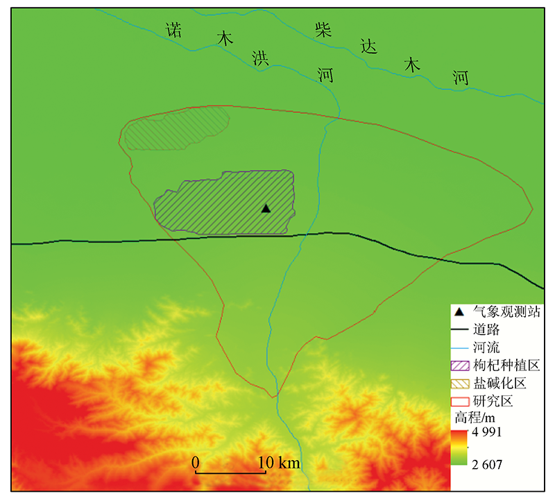
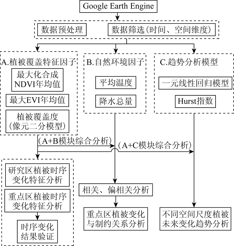
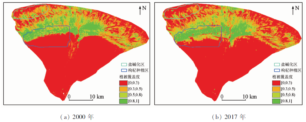
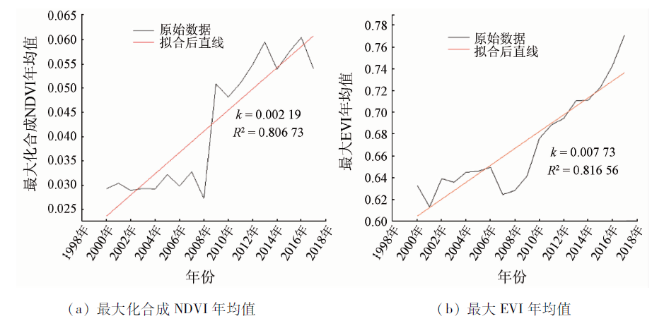
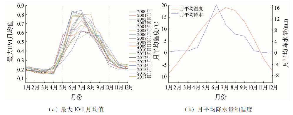
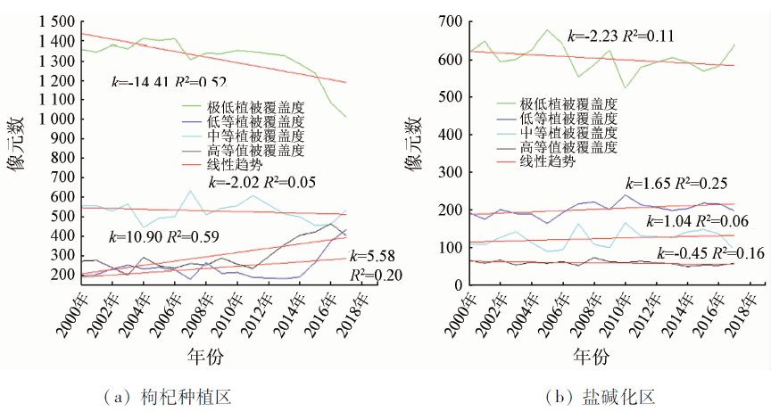
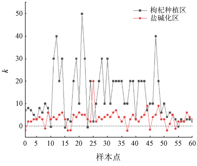
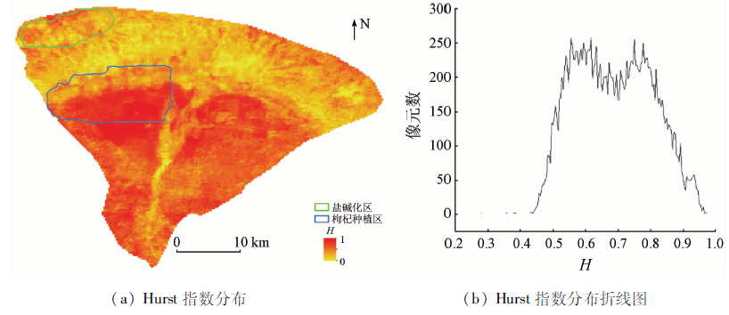
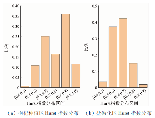
Google Earth Engine enables some limitations in the remote sensing monitoring of vegetation to be overcome, including difficult data acquisition, large local storage capacity, and low processing efficiency. Using GEE, the data of satellites Landsat and MODIS (spatial resolution: 30 m and 250 m, respectively), and temperature and precipitation data, this study investigated the spatio-temporal change trends and sustainability of the vegetation in the Nuomuhong alluvial fan in Qinghai Province during 2000—2017. Moreover, this study analyzed the relationships of vegetation between wolfberry plantations and salinized areas on the alluvial fans of different eras and the future changes of the relationships. The results are as follows: ① The average annual maximum synthetic normalized difference vegetation index (NDVI) increased from 0.029 to 0.054 during 2000—2017, with an increased amplitude of 0.025. The average annual enhanced vegetation index (EVI) increased from 0.633 to 0.771 during these years, with an increased amplitude of 0.138. The multiyear average maximum EVI showed that EVI peaks occurred from May to October each year. ② A correlation analysis and a partial correlation analysis were conducted between the average maximum EVI and the temperature and precipitation data. According to the analytical results, the correlation coefficient between the average maximum EVI and temperature was 0.839, indicating a strong positive correlation. Meanwhile, the correlation coefficient between the average maximum EVI and precipitation amount was 0.457, indicating a weak positive correlation. ③ Over 18 years, the vegetation in wolfberry plantations was rapidly improved, while the vegetation in the salinized area degenerated. ④ The future changes in the vegetation in wolfberry planting areas and salinized areas will have strong sustainability. The vegetation growth in wolfberry planting areas will continuously restrict the vegetation in the salinized area to a certain extent in a period in the future.
姚金玺, 张志, 张焜. 基于GEE的诺木洪洪积扇植被时空变化特征、成因及趋势分析[J]. 自然资源遥感, 2022, 34(1): 249-256.
YAO Jinxi, ZHANG Zhi, ZHANG Kun. An analysis of the characteristics, causes, and trends of spatio-temporal changes in vegetation in the Nuomuhong alluvial fan based on Google Earth Engine. Remote Sensing for Natural Resources, 2022, 34(1): 249-256.
Zhang X Z, Zheng J Y, He F N, et al. Spatial differences of variations in autumn fractional vegetation coverage in Eastern China during 1982—2006[J]. Journal of Natural Resources, 2013, 28(1):28-37.
[2]
Wang X, Hua T, Lang L, et al. Spatial differences of aeolian desertification responses to climate in arid Asia[J]. Global and Planetary Change, 2017, 148:22-28.
doi: 10.1016/j.gloplacha.2016.11.008
[3]
Yang L M, Bruce K W, Larry L T, et al. An analysis of relationships among climate forcing and time-integrated NDVI of grasslands over the U.S. Northern and Central Great Plains[J]. Remote Sensing of Environment, 1998, 65(1):25-37.
doi: 10.1016/S0034-4257(98)00012-1
[4]
Yang W, Yang Z, Merchant J W. An assessment of AVHRR NDVI eco-climatological relations in Nebraska,USA[J]. International Journal of Remote Sensing, 1997, 18(10):2161-2180.
doi: 10.1080/014311697217819
Chen F H, Fu B J, Xia J, et al. Major advances in studies of the physical geography and living environment of China during the past 70 years and future prospects[J]. Science China:Earth Sciences, 2019, 49(11):1659-1696.
Xu H J, Yang T B. Spatial-temporal variations of vegetation activities and its responses to climatic factors in the Qaidam Basin[J]. Journal of Natural Resources, 2014, 29(3):398-407.
Wang L L, Liu P X, Wang Y. Spatial and temporal variations of NDVI and its influencing factors in Qaidam Basin in the last 14 years[J]. Chinese Journal of Ecology, 2015, 34(6):1713-1722.
Zhang S Q, Chen H, Song J M, et al. Spatial and temporal variation of fractional vegetation cover and its relationship with environmental factors in the Qaidam Basin during 2000—2015[J]. Arid Land Geography, 2019, 42(5):1124-1131.
Li Y L, Yang T B, Zeng B. Land cover change of southern fringe oasis in the Qaidam Basin from 2000 to 2009 based on MODIS data[J]. Journal of Desert Research, 2011, 31(1):34-41.
[10]
Gorelick N, Hancher M, Dixon M, et al. Google Earth Engine:Planetary-scale geosptial analysis for everyone[J]. Remote Sensing of Environment, 2017, 202:18-27.
doi: 10.1016/j.rse.2017.06.031
[11]
Goldblatt R, You W, Hanson G, et al. Detection the boundaries of urban areas in India:A dataset for pixel-based image classification in Google Earth Engine[J]. Remote Sensing, 2016, 8(8):634.
doi: 10.3390/rs8080634
[12]
Dong J, Xiao X, Menarguez M A, et al. Mapping paddy rice planting area in northeastern Asia with Landsat8 image,phenology-based algorithm and Google Earth Engine[J]. Remote Sensing of Environment, 2016, 185:142-154.
doi: 10.1016/j.rse.2016.02.016
[13]
Fu Y, Chen H, Niu H, et al. Spatial and temporal variation of vegetation phenology and its response to climate changes in Qaidam Basin from 2000 to 2015[J]. Journal of Geographical Sciences, 2018, 28(4):400-414.
doi: 10.1007/s11442-018-1480-2
Sun L G, Liu J F, Xu Q H. Remote sensing based temporal and spatial analysis of vegetation over changes in Bashang area of Hebei Province[J]. Remote Sensing for Land and Resources, 2014, 26(1):167-172.doi: 10.6046/gtzyyg.2014.01.28.
doi: 10.6046/gtzyyg.2014.01.28
Xu J X, Fang S B, Zhang T B, et al. NDVI changes and its correlation with climate factors of the Three River-Headwater region in growing seasons during 2000—2016[J]. Remote Sensing for Land and Resources, 2020, 32(1):237-246.doi: 10.6046/gtzyyg.2020.01.32.
doi: 10.6046/gtzyyg.2020.01.32
Cai B F, Yu R. Advance and evaluation in the long time series vegetation trends research based on remote sensing[J]. Journal of Remote Sensing, 2009, 13(6):1170-1186.
[17]
Hurst H E. Long term storage capacity of reservoirs[J]. American Society of Civil Engineers Transactions, 1951, 116(776):770-808.
doi: 10.1061/TACEAT.0006518
[18]
Granero M A S, Segovia J E T, Pérez J G. Some comments on Hurst exponent and the long memory processes on capital markets[J]. Physica A:Statistical Mechanics and Its Applications, 2008, 387(22):5543-5551.
doi: 10.1016/j.physa.2008.05.053
Liu M X, Liu Y C, Chen M, et al. Spatiotemporal evolution of vegetation coverage and its response to climate change in upper reaches of Ganjiang River basin during 2000—2018[J]. Bulletin of Soil and Water Conservation, 2020, 40(5):284-290.
Xu H J, Yang T B. Climate factors change and its impact on lake area and vegetation growth in the Qaidam Basin during 1981—2010[J]. Progress in Geography, 2013, 32(6):868-875.
Liang S Z, Yu D F, Wang M, et al. Application of remote sensing time-series data to investigate the relationship between vegetation change and climatic factors:A case study of Circum-Bohai Sea area[J]. Remote Sensing for Land and Resources, 2015, 27(3):114-121.doi: 10.6046/gtzyyg.2015.03.19.
doi: 10.6046/gtzyyg.2015.03.19
Zhang H, An H M. Analysis of NDVI variation characteristics and trend of Minqin Oasis from 1987 to 2019 based on GEE[J]. Journal of Desert Research, 2021, 41(1):28-36.
Chang C, Wang X Y, Yang R X, et al. A quantitative characterization method for alpine vegetation zone based on DEM and NDVI[J]. Geographical Research, 2015, 34(11):2113-2123.
 2022, Vol. 34
  ), 张志1(