An analysis of the pattern of land-use conflicts in valley oases in arid areas
WANG Juanjuan1(), WU Zhaopeng1,2(), WANG Shanshan1, YIN Huihui1
1. College of Geography Science and Tourism, Xinjiang Normal University, Urumqi 830054, China 2. Laboratory of Lake Environment and Resources in Arid Area of Xinjiang, Urumqi 830054, China
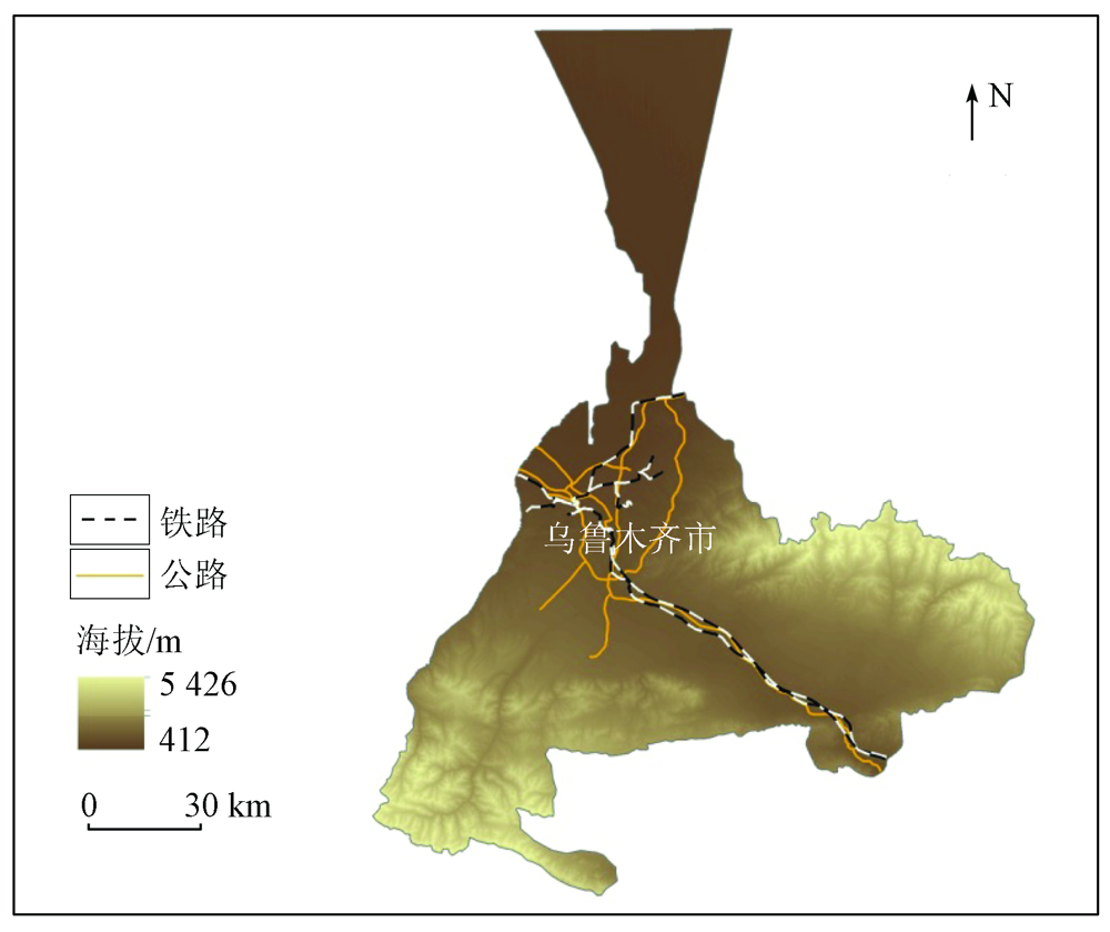
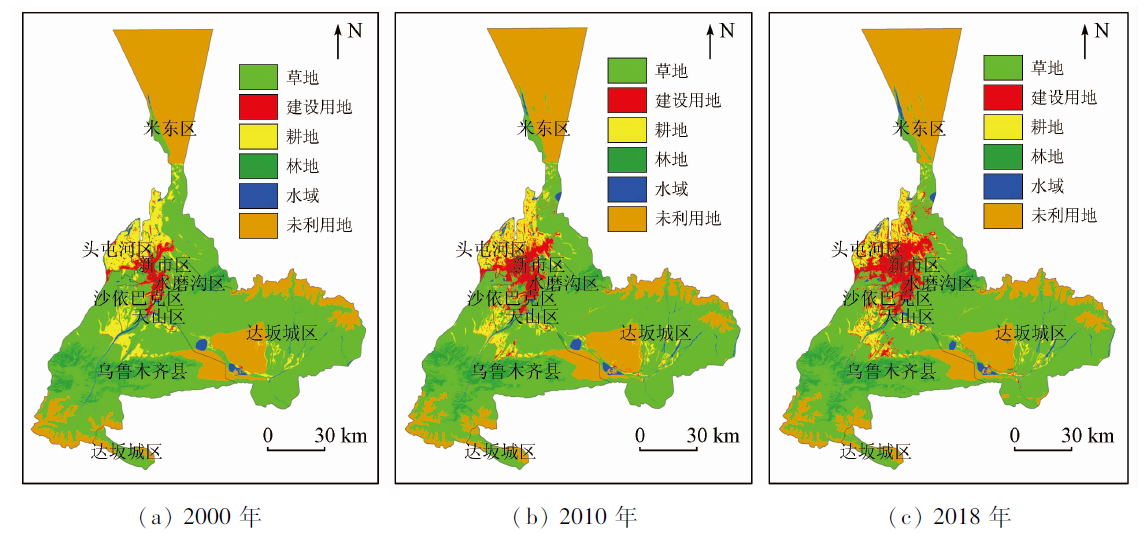
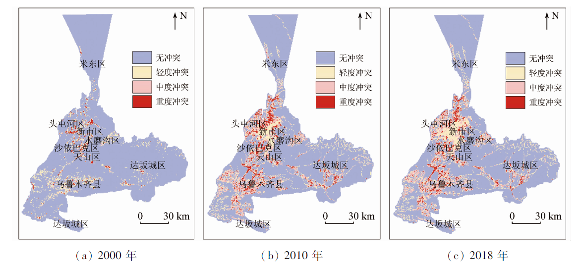
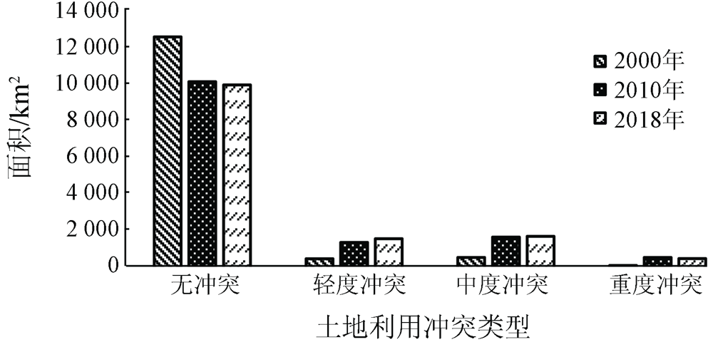
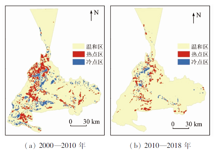
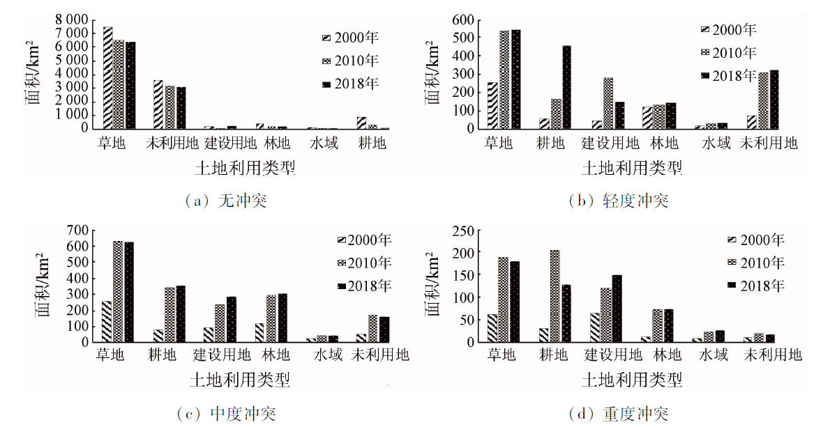
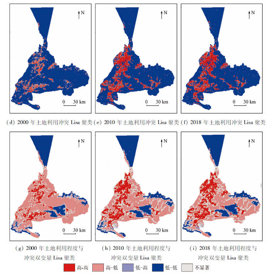
The identification of land-use conflicts is of great significance for maintaining the balance between ecological protection and the socio-economic development in oases in arid areas. Based on the data of land use status in 2000, 2010, and 2018 of Urumqi City-a valley oasis in the Urumqi River Basin, this paper constructs a comprehensive measurement model of land-use conflicts and further analyzes the distribution characteristics of the spatial pattern of land-use conflicts using the methods of spatial autocorrelation and cold/hot spot analysis. The results are as follows. ① The total area of land-use conflicts has increased year by year, and the area of lands with different land-use conflict levels is in the order of no conflict > moderate conflicts > mild conflicts > severe conflicts. Meanwhile, land-use conflicts are more liable to occur in grassland, cultivated land, construction land, and woodland. ② There is a significant spatial positive correlation between land-use conflicts in the study area, and the land-use conflicts are highly concentrated in terms of space. According to the analysis of cold and hot spots, it is found that from 2000 to 2018, the hot spots of land-use conflicts migrated from the northern part of the central urban area and southwestern parts to the eastern and southern parts of the urban area, with the distribution scope narrowing. In comparison, the cold spots of the land-use conflicts mainly concentrated inside the central urban area and the eastern and southern mountainous areas. ③ There is a positive spatial correlation between the land use degree and the land-use conflicts in the study area. C0/(C0+C) increased from 0.21 to 0.49 during 2000—2018, indicating that the spatial correlation weakened and the land-use conflicts are increasingly affected by random factors.
王娟娟, 毋兆鹏, 王珊珊, 尹慧慧. 干旱区河谷绿洲土地利用冲突格局分析[J]. 自然资源遥感, 2021, 33(4): 243-251.
WANG Juanjuan, WU Zhaopeng, WANG Shanshan, YIN Huihui. An analysis of the pattern of land-use conflicts in valley oases in arid areas. Remote Sensing for Natural Resources, 2021, 33(4): 243-251.
Yu B H, Lv C H. The progress and prospect of land use conflicts[J]. Progress in Geography, 2006,25(3):106-115.
[3]
Campbell D J, Gichohi H, Mwangi A, et al. Land use conflict in Kajiado District,Kenya[J]. Land Use Policy, 2000,17(4):337-348.
doi: 10.1016/S0264-8377(00)00038-7
Liu G L, Yan F T, Xu S C, et al. The strategic disposition between the conflict and coordination from internal and external space in urban development:Taking Shijiazhuang City as a case[J]. Geographical Research, 2006(4):701-709,756.
[6]
Zhao L Y, Peng Z R. Land system:An agent-based cellular automata model of land use change developed for transportation analysis[J]. Journal of Transport Geography, 2012,25(3):35-49.
doi: 10.1016/j.jtrangeo.2012.07.006
Liao L H, Dai W Y, Chen J, et al. Spatial conflict between ecological-production-living spaces on Pingtan Island during rapid urbanization[J]. Resources Science, 2017,39(10):1823-1833.
[9]
Siebert S. Agricultural,architectural and archaeological evidence for the role and ecological adaptation of a scattered mountain oasis in Oman[J]. Journal of Arid Environments, 2005,62(7):177-197.
doi: 10.1016/j.jaridenv.2004.09.023
[10]
周骏. 基于社会燃烧理论的农村土地冲突原因及其治理研究[D]. 南昌:南昌大学, 2013.
Zhou J. Research on the cause and countermeasure of land conflicts based on social burning theory[D]. Nanchang:Nanchang University, 2013.
Zeng L, Yang Q Y, Yang R H, et al. Landscape pattern optimization for ecological barrier in the Three Gorges Reservoir Area:A case study in Jiangjin,Chongqing[J]. Chinese Journal of Ecology, 2017,36(5):1364-1373.
XU X Y, Liu Z Y, Dong L, et al. Research on the mutual relationship between industrial structure and land utilization structure from the perspective of national land space planning:Taking Urumqi of Xinjiang as an example[J]. Ecological Economy, 2020,36(4):69-74.
Pei B, Pan T. Land use system dynamic modeling:Literature review and future research direction in China[J]. Progress in Geography, 2010,29(9):1060-1066.
Yang G A, Gan G H. Land scape pattern change research of land use in Beijing based on fractal theory[J]. Systems Engineering-theory & Practice, 2004(10):131-137.
Peng J J, Zhou G A, Tang C L, et al. The analysis of spatial conflict measurement in fast urbanization region based on ecological security:A case study of Changsha Zhuzhou Xiangtan urban agglomeration[J]. Journal of Natural Resources, 2012,27(9):1507-1519.
[16]
秦坤. 基于生态安全的土地利用空间冲突研究——以武汉城市圈[D]. 武汉:武汉大学, 2017.
Qin K. The analysis of land use spatial conflicts based on ecological security:A case study of the urban agglomeration around Wuhan[D]. Wuhan:Wuhan University, 2017.
Zhou G H, PPeng J J. The evolution characteristic sand influence effect of spatial conflict:A case study of Changsha-Zhuzhou-Xiangtan urban agglomeration[J]. Progress in Geography, 2012,31(6):717-723.
Wang S Y, Liu J Y, Zhang Z X, et al. Analysis on spatial-temporal features of land use in China[J]. Acta Geographica Sinica, 2001(6):631-639.
doi: 10.11821/xb200106001
Sang X, Guo Q Z, Pan Y Y, et al. Research on land use dynamic change and prediction in Lucheng City of Shanxi Province based on TM and OLI[J]. Remote Sensing for Land and Resources, 2018,30(2):125-131.doi: 10.6046/gtzyyg.2018.02.17.
doi: 10.6046/gtzyyg.2018.02.17
[20]
王秀兰, 包玉海. 土地利用动态变化研究方法探讨[J]. 地理科学进展, 1999(1):3-5.
Wang X L, Bao Y H. Study on the methods of land use dynamic change research[J]. Progress in Geography, 1999(1):3-5.
Zhang J F, Meng F H, Bao A M, et al. LUCC analysis of the upstream of the Kongqi River,Xinjiang China[J]. Journal of Desert Research, 2018,38(3):664-672.
Tang H, Qiao X N, Yang D G, et al. Characteristics of temporal and spatial dynamic changes of land use and their relationship with regional development——A case study in the Weigan River Basin[J]. Agricultural Research in the Arid Areas, 2012,30(3):205-213.
You W B, He D J, Wu L Y, et al. Temporal spatial differentiation and its change in the landscape ecological security of Wuyishan Scenery District[J]. Acta Ecologica Sinica, 2011,31(21):6317-6327.
 2021, Vol. 33
  ), 毋兆鹏1,2(