Tobacco fine extraction from UAV image based on fuzzy-superpixel segmentation algorithm
XIA Yan1(), HUANG Liang1,2(), CHEN Pengdi1
1. College of Land and Resources Engineering, Kunming University of Technology, Kunming 650093, China 2. Application Engineering Research Center of Spatial Information Mapping Technology in Plateau Mountainous Area of Yunnan Province, Kummimg 650093, China
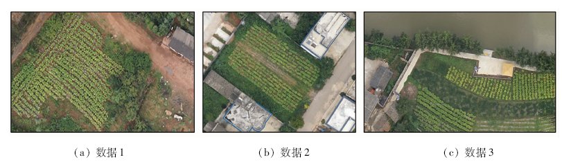
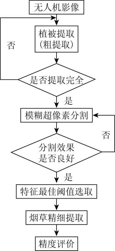
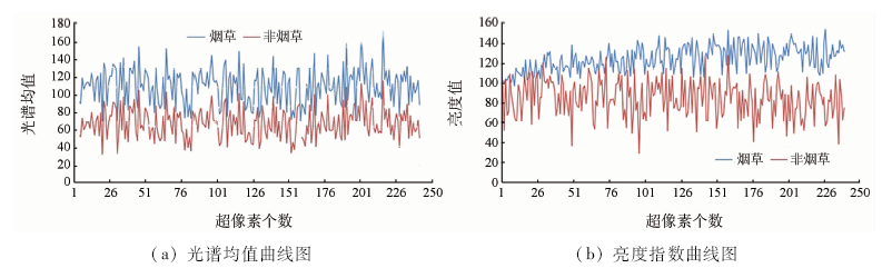
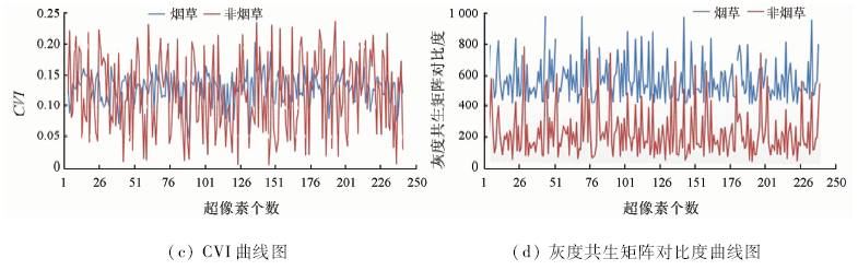
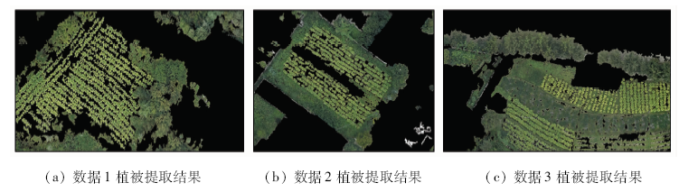
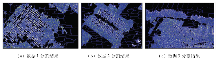
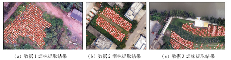
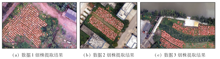
The successful extraction of tobacco single plant automation is of great significance to the realization of tobacco agricultural information, but there are still great difficulties in tobacco fine extraction. Therefore, a tobacco extraction method based on Fuzzy superpixels (FS) algorithm is proposed. Firstly, vegetation coverage area in UAV image is obtained by green space extraction method; secondly, super-pixel segmentation of image is carried out by using FS algorithm, and the mean value, brightness, shape index, aspect ratio, custom vegetation index and other features of super-pixel are counted; finally, the number of tobacco plants is extracted and counted by calculating the feature threshold of super-pixel. Three UAV images were selected as the experimental data. The experimental results show that the overall accuracy of this method is 84.28%, 89.05% and 82.97% respectively. This method can be used for automatic extraction of tobacco plant and can provide effective reference for later calculation of tobacco yield.
Li Y B, Wang P, Wang B, et al. Problems in the development of modern tobacco agriculture and countermeasures[J]. Modern Agricultural Science and Technology, 2019(9):244-246.
Chen M, Zhang L Q, Zhou Z L, et al. Tobacco planting technology and field management measures[J]. Henan Agriculture, 2018(35):17-18.
[3]
Han L. Recognition of the part of growth of flue-cured tobacco leaves based on support vector machine[C]// World Congress on Intelligent Control & Automation.IEEE, 2008: 3624-3627.
Wu M Q, Cui Q C, Zhang L, et al. Tobacco field monitoring and classification method study in mountainous area[J]. Remote Sensing Technology and Application, 2008,23(3):305-309.
[5]
Guru D S, Mallikarjuna P B, Manjunath S. Segmentation and classification of tobacco seedling diseases[C]// Proceedings of the Fourth Annual ACM Bangalore Conference.ACM, 2011: 1-5.
[6]
李天坤. 基于面向对象分类方法的烟草种植面积提取研究[D]. 成都:四川农业大学, 2013.
Li T K. Extraction of tobacco planting area based on object-oriented classification method[D]. Chengdu:Sichuan Agricultural University, 2013.
Dong M, Su J D, Liu G Y, et al. Extraction and monitoring of tobacco planting surface based on object-oriented UAV Remote Sensing Image[J]. Surveying and Mapping Science, 2014,39(9):87-90.
Chen J, Liu P C, Huang G Q, et al. Information extraction of tobacco planting area based on unmanned aerial vehicle remote sensing images[J]. Hunan Agricultural Science, 2018(1):96-99,103.
Liu M Q, Li X J, Yang Y H, et al. Estimation of the intercropped tobacco area in mountainous area based on ZY-3 remote sensing images[J]. Journal of Anhui Agricultural Sciences, 2016(3):291-293.
Wang Z, Chen Y L, Mo J F, et al. Recognition of flue-cured tobacco crop based on spectral characteristics extracted from HJ-1 remote sensing images[J]. Tobacco Science and Technology, 2014(1):72-76.
[12]
付静. 基于无人机图像的山区烟株数量统计方法与试验[D]. 贵阳:贵州大学, 2019.
Fu J. Method and experiment of tobacco number statistics in mountainous area based on UAV image[D]. Guiyang:Guizhou University, 2019.
Li X S, Liu Y F, Chen D H, et al. Cloud detection based on support vector machine with image features for GF-1 data[J]. Remote Sensing of Land and Resources, 2020,32(3):55-62.doi: 10.6046/gtzyyg.2020.03.08.
Lou P Q, Chen X Y, Wang S T, et al. Object recognition of karst farming area based on UAV image:A case study of Guilin[J]. Remote Sensing for Land and Resources, 2020,32(1):216-223.doi: 10.6046/gtzyyg.2020.01.29.
Yan X C, Huang Z K, Ma Y L, et al. Analysis of characteristics and application of Otsu threshold method[J]. Journal of Nanchang Institute of Technology, 2019,38(1):85-90,97.
Bao C X, Jiang W, Wang Y X. Automatic focusing algorithm based on Otsu segmentation and local maximum gradient[J]. Optical Technique, 2019,45(6):756-761.
Cai H Y, Yao G Q. Optimized method for road extraction from high resolution remote sensing image based on watershed algorithm[J]. Remote Sensing for Land and Resources, 2013,25(3):25-29.doi: 10.6046/gtzyyg.2013.03.05.
Xie X J, Zhao J S, Chen X H, et al. SPA-based K-means clustering algorithm for remote sensing image[J]. Remote Sensing for Land and Resources, 2012,24(4):82-87.doi: 10.6046/gtzyyg.2012.04.14.
Liu C Q, Shao K, Huo X, et al. K-means image segmentation algorithm based on weighted quality evaluation function[J]. Computer Science, 2019,46(z1):158-160,187.
Huang L, Yao B X, Chen P D, et al. Superpixel segmentation method of high-resolution remote sensing image based on fuzzy clustering[J]. Acta Geodaetica et Cartographica Sinica, 2020,49(5):589-597.
[21]
Guo Y, Jiao L, Wang S, et al. Fuzzy-superpixels for polarimetric SAR images classification[J]. IEEE Transactions on Fuzzy Systems, 2018: 2814591.
 2021, Vol. 33
  ), 黄亮1,2(