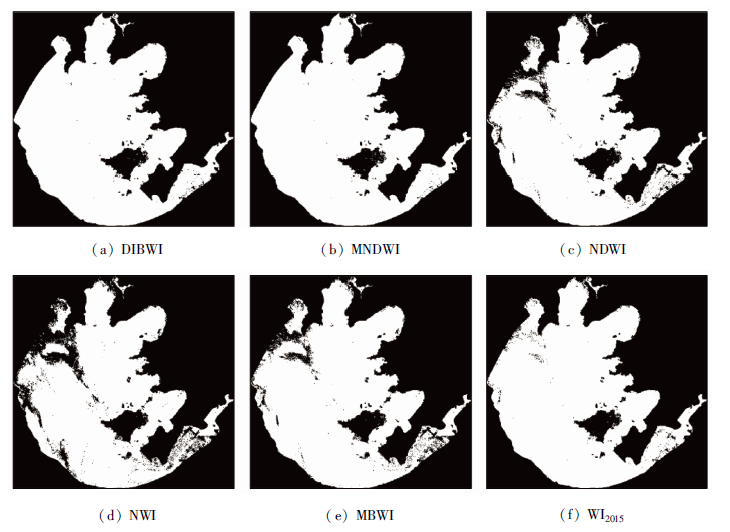
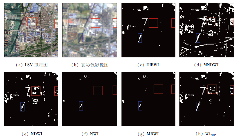
21世纪以来,太湖地区蓝藻的爆发严重影响了当地水资源的开发与利用。以太湖蓝藻为研究对象,以快速提取含蓝藻水体为目标,基于Landsat8影像对比分析了非蓝藻水体与含蓝藻水体光谱反射特征。含蓝藻水体在近红外波段表现出强反射率特征,而在蓝光、绿光、红光、短波红外波段的反射特征与非蓝藻水体一致,据此提出了一种提取含蓝藻水体信息的方法——双红外水体指数(double infrared band water index, DIBWI)。基于太湖地区2014年和2017年的Landsat8影像,与归一化差异水体指数(normalized difference water index, NDWI)、改进的归一化差异水体指数(modified normalized difference water index, MNDWI)、新型水体指数(new water index, NWI)、多波段水体指数(multi-band water index, MBWI)和水体指数2015(water index 2015, WI2015)这5种水体指数提取结果进行了对比分析,并利用2013年、2016年和2018年3期数据进行验证。结果表明,DIBWI能够较完整地提取含蓝藻水体信息,有效消除蓝藻影响并能抑制背景地物,总体精度达到98%以上,Kappa系数大于0.95,可以为太湖地区水资源保护、合理开发利用提供技术支撑。
Since the 21st century, the outbreak of cyanobacteria in the Taihu Lake has seriously affected the development and utilization of local water resources. Based on Landsat8 imagery, this paper analyzes the spectral reflection characteristics of non-cyanobacteria water and cyanobacteria water. Cyanobacteria water shows strong reflectance characteristics in the near-infrared band, but the reflectance characteristics in the blue, green, red and shortwave-infrared bands are the same as those in non-cyanobacteria water. On such a basis, a method for extracting cyanobacteria water information, i.e., double infrared band water index (DIBWI), is proposed. On the basis of the Landsat8 imageries of 2014 and 2017 in Taihu Lake area, the comparison and analysis were made with the results of normalized difference water index (NDWI), modified normalized difference water index (MNDWI), new water index (NWI), multi-band water index (MBWI) and water index 2015 (WI2015), and the data of 2013, 2016 and 2018 were used for verification. The results show that DIBWI can extract the cyanobacteria water information, effectively eliminate the influence of cyanobacteria and better inhibit the background features. The overall accuracy is above 98%, and the Kappa coefficient is more than 0.95, which can provide technical support for the protection and reasonable development and utilization of water resources in Taihu Lake area.
王琳, 谢洪波, 文广超, 杨运航. 基于Landsat8的含蓝藻湖泊水体信息提取方法研究[J]. 国土资源遥感, 2020, 32(4): 130-136.
WANG Lin, XIE Hongbo, WEN Guangchao, YANG Yunhang. A study on water information extraction method of cyanobacteria lake based on Landsat8. Remote Sensing for Land & Resources, 2020, 32(4): 130-136.
Li S J. Suggestions on the environmental evolution and geochemical research of lakes (reservoirs)[J]. Bulletin of Mineralogy,Petrology and Geochemistry, 2016,35(4):2.
[2]
Liu J, Yang W. Water sustainability for China and beyond[J]. Science, 2012,337(6095):649-650.
doi: 10.1126/science.1219471
[3]
Feng M, Sexton J O, Channan S, et al. A global,high-resolution (30-m) inland water body dataset for 2000:First results of a topo-graphic-spectral classification algorithm[J]. International Journal of Digital Earth, 2015:1-21.
Feng H E, Li J G, Zhu Y F, et al. Synergistic inversion method of chlorophyll a concentration in GF-1 and Landsat8 imagery:A case study of the Taihu Lake[J]. Remote Sensing for Land and Resoures, 2019,31(4):182-189.doi: 10.6046/gtzyyg.2019.04.24.
[5]
朱喜. 太湖蓝藻大爆发的警示和启发[J]. 上海企业, 2007(7):7-9,13.
Zhu X. Warning and inspiration of cyanobacteria bloom in Taihu Lake[J]. Shanghai Enterprise, 2007(7):7-9,13.
Zhu X, Zhu Y. Problems and countermeasures of controlling cyanobacteria bloom in Taihu Lake[J]. Journal of Environmental Engineering Technology, 2019,9(6):714-719.
Zhang Y, Chen C Z, Wu G P, et al. Effects of spatial scale on water surface delineation with satellite images[J]. Journal of Lake Sciences, 2015,27(2):335-342.
Sun P, Wang Q F, Zhang M R, et al. A method to enhance information of water cover based on feature space of NDVI and MNDWI[J]. Journal of Hubei University(Natural Science), 2018,40(6):574-579.
[9]
Ashraf M, Nawaz R. A comparison of change detection analyses using different band algebras for baraila wetland with NASA’s multi-temporal Landsat dataset[J]. Journal of Geographic InformationSystem, 2015,7(1):1-19.
[10]
McFeeters S K. The use of the normalized difference water index(NDWI) in the delineation of open water feature[J]. International Journal of Remote Sensing, 1996,17(7):1425-1432.
Xu H Q. A study on information extraction of water body with the modified normalized difference water index(MNDWI)[J]. Journal of Remote Sensing, 2005,9(5):589-595.
Ding F. Study on information extraction of water body with a new water index(NWI)[J]. Science of Surveying and Mapping, 2009,34(4):155-157.
[13]
Fisher A, Flood N, Danaher T. Comparing Landsat water index methods for automated water classification in eastern Australia[J]. Remote Sensing of Environment, 2016,175:167-182.
[14]
Wang X B, Xie S P, Zhang X L, et al. A robust multi-band water index (MBWI) for automated extraction of surface water from Landsat8 OLI imagery[J]. International Journal of Applied Earth Observation and Geoinformation, 2018,68:73-91.
Chen R H. Taihu Lake basin water quality contamination water quality electromyographic space analysis[J]. Environment and Development, 2018,30(5):54,56.
Zhou G H, Liu Q H, Ma R H, et al, Inversion of chlorophyll-a concentration in turbid water of lake Taihu based on optimized multi-spectral combination[J]. Journal of Lake Sciences, 2008(2):17-23.
[19]
Li W B, Du Z Q, Ling F, et al. A comparison of land surface water mapping using the normalized difference water index from TM,ETM+ and ALI[J]. Remote Sensing, 2013,5(11):5530-5549.
 2020, Vol. 32
  ), 谢洪波, 文广超(