Inversion of moisture in surface soil of farmland in karst mountainous areas using multi-temporal SAR images
ZHANG Shu1,2,3(), ZHOU Zhongfa1,2(), WANG Lingyu1,3, CHEN Quan1,2, LUO Jiancheng4, ZHAO Xin1,3
1. School of Geography and Environmental Science/School of Karst Science, Guizhou Normal University, Guiyang 550001, China 2. The State Key Laboratory Incubation Base for Karst Mountain Ecology Environment of Guizhou Province, Guiyang 550001, China 3. State Engineering Technology Institute for Karst Desertification Control, Guiyang 550001, China 4. Aerospace Information Research Institute, Chinese Academy of Sciences, Beijing 100101, China
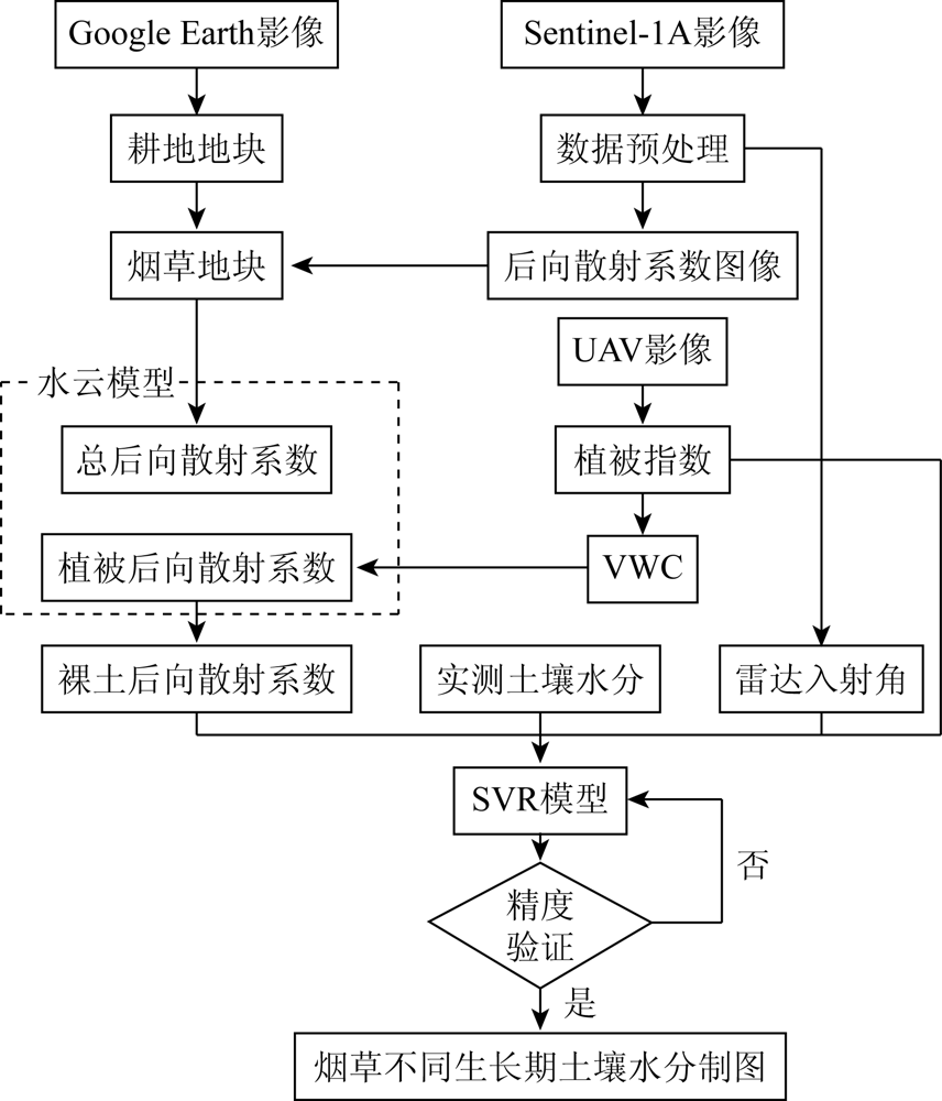
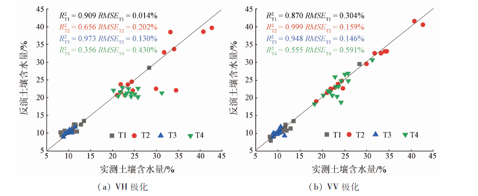
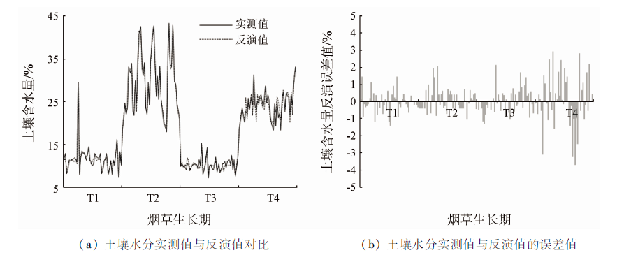
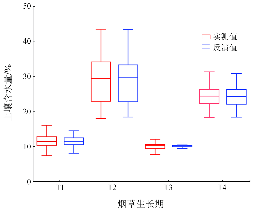
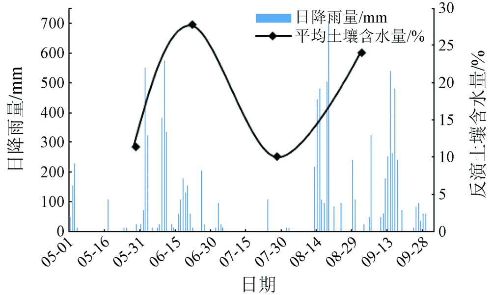
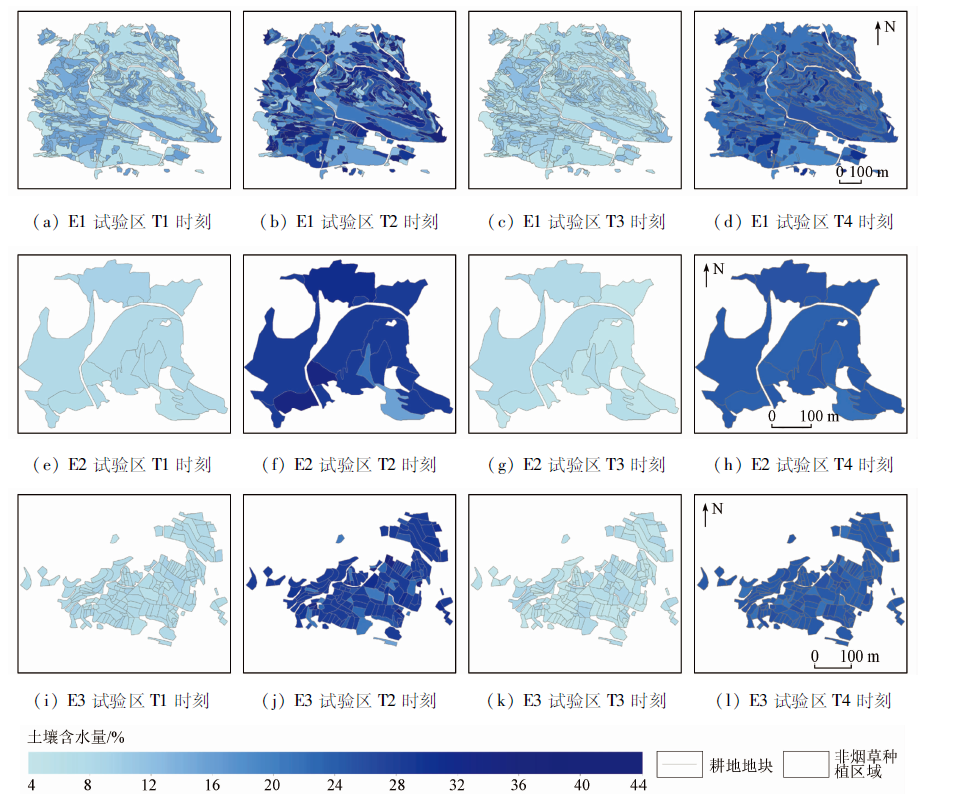
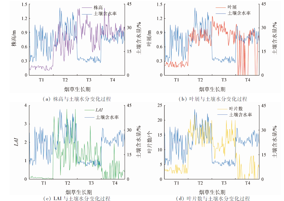
The farmland’s soil moisture plays an important role in crop yield estimation and drought monitoring and is also a key parameter for fine-scale monitoring of farmland in karst mountainous areas. Targeting the complex environmental impacts in karst regions such as farmland fragmentation and the fact that the inversion of soil moisture is vulnerable to cloud interference, this study employed both the water cloud model (WCM) and the support vector regression (SVR) model to conduct the block-scale inversion of the soil moisture in the growth periods of tobacco using the multi-temporal Sentinel-1 synthetic aperture Radar (SAR) images and the unmanned aerial vehicle (UAV) RGB images. The results are as follows. ① In this study, conventional vegetation parameters were replaced with the visible-band difference vegetation index (VDVI), which combined with its water cloud model was highly applicable to karst mountainous areas. The co-polarization method yielded higher inversion precision, with a coefficient of determination of 0.843 and RMSE of 0.983%. These provide a convenient method for the inversion of farmland’s soil moisture in cloudy and rainy mountainous areas. ② The trend of soil moisture in the four growth periods of tobacco is consistent with that of precipitation. Farmland with rocky desertification has low soil moisture, which is closely related to the bare rocks, complex terrain, and difficulties with irrigation in the experimental area. ③ Soil moisture has significant effects on tobacco growth. Specifically, high soil moisture promotes tobacco growth and low soil moisture inhibits tobacco growth, especially during T1—T3. This study can be utilized as a reference for the fine-scale inversion of the farmland’s soil moisture in cloudy and rainy mountainous areas.
张淑, 周忠发, 王玲玉, 陈全, 骆剑承, 赵馨. 多时相SAR的喀斯特山区耕地表层土壤水分反演[J]. 自然资源遥感, 2022, 34(3): 154-163.
ZHANG Shu, ZHOU Zhongfa, WANG Lingyu, CHEN Quan, LUO Jiancheng, ZHAO Xin. Inversion of moisture in surface soil of farmland in karst mountainous areas using multi-temporal SAR images. Remote Sensing for Natural Resources, 2022, 34(3): 154-163.
Anagnostopoulos V, Petropoulos G P, Ireland G, et al. A modernized version of a 1D soil vegetation atmosphere transfer model for improving its future use in land surface interactions studies[J]. Environmental Modelling and Software, 2017(90):147-156.
[2]
Bolten J D, Crow W T, Zhan X, et al. Evaluating the utility of remotely sensed soil moisture retrievals for operational agricultural drought monitoring[J]. IEEE Journal of Selected Topics in Applied Earth Observations and Remote Sensing, 2010, 3(1):57-66.
doi: 10.1109/JSTARS.2009.2037163
[3]
Mccoll K A, Alemohammad S H, Akbar R, et al. The global distribution and dynamics of surface soil moisture[J]. Nature Geoence, 2017, 10(2):100-104.
Luo Z C, Du W, Zhang W X. The progress on the effect of soil water on growth and development and physiological metabolism of Tobacco[J]. Journal of Mountain Agriculture and Biology, 2009, 28(5):446-451.
[5]
Al Y A, Wigneron J P, Ducharne A, et al. Global-scale evaluation of two satellite-based passive microwave soil moisture datasets (SMOS and AMSR-E) with respect to land data assimilation system estimates[J]. Remote Sensing of Environment, 2014, 149(1): 181-195.
doi: 10.1016/j.rse.2014.04.006
[6]
Hajnsek I, Jagdhuber T, Schcoen H, et al. Potential of estimating soil moisture under vegetation cover by means of PolSAR[J]. IEEE Transactions on Geoscience and Remote Sensing, 2009, 47(2): 442-454.
doi: 10.1109/TGRS.2008.2009642
[7]
Trudel M, Charbonneau F, Leconte R. Using RADARSAT-2 polarimetric and ENVISAT-ASAR dual-polarization data for estimating soil moisture over agricultural fields[J]. Canadian Journal of Remote Sensing, 2012, 38(4): 514-527.
[8]
Ulaby F T, Sarabandl K, Mcdonald K. Michigan microwave canopy scattering model[J]. International Journal of Remote Sensing, 1990, 11(7):1223-1253.
doi: 10.1080/01431169008955090
[9]
Joseph A T, Van d V R, O’Neill P E, et al. Soil moisture retrieval during a corn growth cycle using L-cand (1.6 GHz) Radar observations[J]. IEEE Transactions on Geoscience and Remote Sensing, 2008, 46(8): 2365-2374.
doi: 10.1109/TGRS.2008.917214
[10]
De Roo R D, Du Y, Ulaby F T, et al. A semi-empirical backscattering model at L-band and C-band for a soybean canopy with soil moisture inversion[J]. IEEE Transactions on Geoscience and Remote Sensing, 2001, 39(4): 864-872.
doi: 10.1109/36.917912
[11]
Attema E P W, Ulaby F T. Vegetation modeled as a water cloud[J]. Radio Science, 1978, 13(2):357-364.
doi: 10.1029/RS013i002p00357
Wang X Q, Wang M M, Wang S Q, et al. Extraction of vegetation information from visible unmanned aerial vehicle images[J]. Transactions of the Chinese Society of Agricultural Engineering, 2015, 31(5):152-159.
Ding L L, Li Q Z, Du X, et al. Vegetation extraction method based on color indices from UAV images[J]. Remote Sensing for Land and Resources, 2016, 28(1):78-86.doi: 10.6046/gtzyyg.2016.01.12.
doi: 10.6046/gtzyyg.2016.01.12
Zhu M, Zhou Z F, Jiang Y, et al. An accurate recognition method of pitaya plants based on visible light band UAV remote sensing[J]. Laser and Optoelectronics Progress, 2020, 57(14):359-368.
Li C Y, Wang P, Pan F B. Using active microwave remote sensing data to detect soil moisture[J]. South-to-North Water Transfers and Water Science and Technology, 2017, 15(2):224-228,253.
[16]
Kim Y, van Zyl J J. A time-series approach to estimate soil moisture using polarimetric Radar data[J]. IEEE Transactions on Geoscience and Remote Sensing, 2009, 47(8):2519-2527.
doi: 10.1109/TGRS.2009.2014944
Zhang X, Chen B Z, Zhao H, et al. Soil moisture change detection over bare agricultural area by means of time-series Sentinel-1A SAR data[J]. Remote Sensing Technology and Application, 2017, 32(2):338-345.
Jiang H, Yusufujiang R, Baihetinisha A, et al. Soil moisture retrieval by synergizing optical and microwave remote sensing data based on support vector machine regression algorithm[J]. Geography and Geo-Information Science, 2017, 33(6):30-36.
Yang G J, Yue J B, Li C C, et al. Estimation of soil moisture in farmland using improved water cloud model and Radarsat-2 data[J]. Transactions of the Chinese Society of Agricultural Engineering, 2016, 32(22):146-153.
Guo J, Liu J, Ning J F, et al. Construction and validation of soil moisture retrieval model in farmland based on Sentinel multi-source data[J]. Transactions of the Chinese Society of Agricultural Engineering, 2019, 35(14):71-78.
Huang Q T, Zeng Z K, Xie G X, et al. Investigation on crop planting structure based on synergy of high spatial-temporal resolution remote sensing data[J]. Journal of Southern Agriculture, 2017, 48(3):552-560.
Zhao X, Zhou Z F, Wang L Y, et al. Extraction and analysis of cultivated land experiencing rocky desertification in Karst mountain areas based on remote sensing:A case study of Beipanjiang Town and Huajiang Town in Guizhou Province[J]. Tropical Geography, 2020, 40 (2):289-302.
doi: 10.13284/j.cnki.rddl.003233
Wang L Y, Chen Q, Wu Y, et al. Accurate recognition and extraction of Karst abandoned land features based on cultivated land parcels and time series NDVI[J]. Remote Sensing for Land and Resources, 2020, 32(3):23-31.doi: 10.6046/gtzyyg.2020.03.04.
doi: 10.6046/gtzyyg.2020.03.04
Liu W, Wu Z F, Luo J C, et al. A divided and stratified extraction method of high-resolution remote sensing information for cropland in hilly and mountainous areas based on deep learning[J]. Acta Geodaetica et Cartographica Sinica, 2021, 50(1):105-116.
[25]
Bindlish R, Barros A P. Parameterization of vegetation backscatter in Radar-based,soil moisture estimation[J]. Remote Sensing of Environment, 2001, 76(1):130-137.
doi: 10.1016/S0034-4257(00)00200-5
[26]
Jackson T J, Schmugge T J. Vegetation effects on the microwave emission of soils[J]. Remote Sensing of Environment, 1991, 36(3): 203-212.
doi: 10.1016/0034-4257(91)90057-D
Liu W X, Wang J, Liu K, et al. Soil moisture data retrieval by active microwave remote sensing on vegetative land[J]. Tropical geo-graphy, 2007(5):411-415,450.
Chen Q, Zhou Z F, Wang L Y, et al. Surface soil moisture retrieval using multi-temporal Sentinel-1 SAR data in Karst rocky desertification area[J]. Journal of Infrared and Millimeter Waves, 2020, 39(5):626-634.
 2022, Vol. 34
  ), 周忠发1,2(