Please wait a minute...
 
自然资源遥感  2021, Vol. 33 Issue (3): 27-35    DOI: 10.6046/zrzyyg.2020330
  技术方法 本期目录 | 过刊浏览 | 高级检索 |
FY-3D/MWRI L1B亮温LST反演与降尺度研究
朱瑜馨1(), 吴门新2(), 鲍艳松3, 李鑫川1, 张锦宗1
1.淮阴师范学院城市与环境学院,淮安 223300
2.国家气象中心,北京 100081
3.南京信息工程大学大气物理学院,南京 210044
LST reversion and downscaling based on FY-3D/MWRI L1B brightness temperature data
ZHU Yuxin1(), WU Menxin2(), BAO Yansong3, LI Xinchuan1, ZHANG Jinzong1
1. School of Urban and Environmental Sciences, Huaiyin Normal University, Huaian 223300, China
2. National Meteorological Centre, Beijing 100081, China
3. School of Atmospheric Physics,Nanjing University of Information Science & Technology, Nanjing 210044, China
全文: PDF(4477 KB)   HTML  
输出: BibTeX | EndNote (RIS)      
摘要 

基于2020年2月1日FY-3C VIRR LST和FY-3D MWRI L1B亮温数据,以18°~54°N,73°~135°E的区域为样例区,利用统计回归模型和层次贝叶斯融合模型,分别进行FY-3D MWRI L1B LST反演和降尺度研究,构建了基于FY-3D 单频率水平和垂直极化亮温的LST二元线性回归反演模型及基于FY-3D反演LST和FY-3C VIRR LST的层次贝叶斯融合降尺度模型,并以MYD11A1 day LST为参考数据进行了验证。结果表明: 反演统计模型,对于FY-3D降轨数据,平均偏差-1.28 K,误差标准差8.85 K,均方根误差8.85 K,对于FY-3D升轨数据,平均偏差-0.81 K,误差标准差6.74 K,均方根误差6.78 K; 层次贝叶斯融合降尺度模型,对于FY-3D降轨数据,平均偏差0.50 K,误差标准差5.45 K,均方根误差5.41 K,对于FY-3D升轨数据,平均偏差0.25 K,误差标准差5.54 K,均方根误差5.54 K,精度满足需求,可以为被动微波LST反演与降尺度提供思路。

服务
把本文推荐给朋友
加入引用管理器
E-mail Alert
RSS
作者相关文章
朱瑜馨
吴门新
鲍艳松
李鑫川
张锦宗
关键词 FY-3D MWRIVIRR LST层次贝叶斯统计回归降尺度    
Abstract

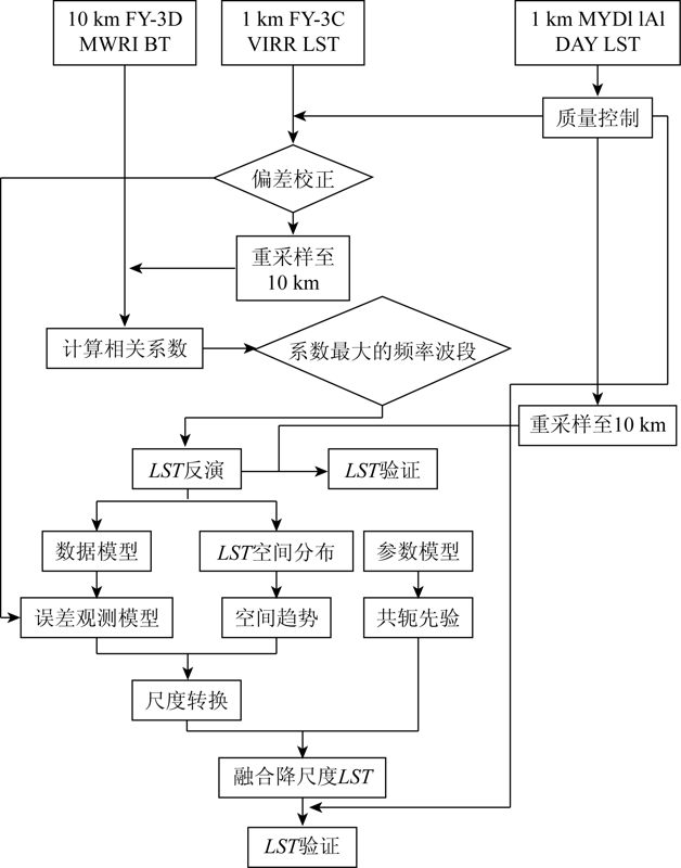
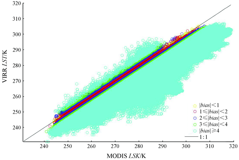
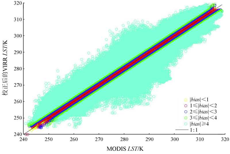
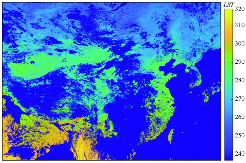
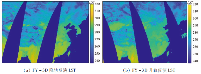
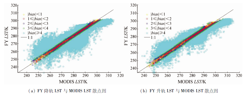
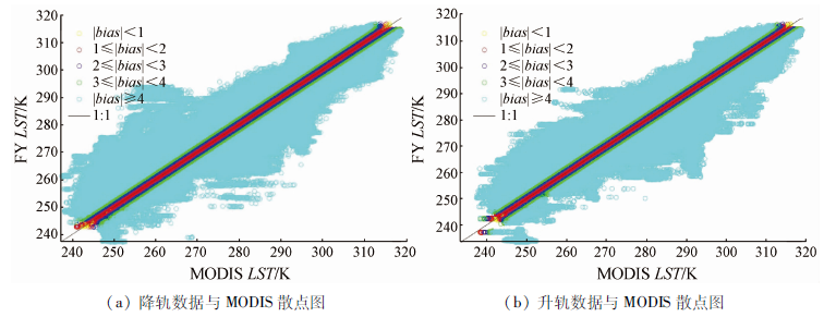
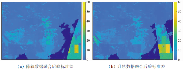
Based on FY-3C VIRR LST and FY-3D/MWRI L1B brightness temperature data of February 1, 2020 and taking the area with geographical coordinates of 18°~54°N, 73°~135°E as an example, the LST reversion and downscaling based on the FY-3D/MWRI L1B data were studied using a statistical regression model and a hierarchical Bayesian fusion model. As a result, two models were constructed, namely a LST binary linear regression inversion model based on FY-3D single-channel horizontal and vertical polarization-corrected brightness temperature data and a hierarchical Bayesian fusion downscaling model based on FY-3D retrieved LST and FY-3C VIRR LST. They were verified with the LST on the day of MYD11A1 as reference data, obtaining the following results. As for the reversion statistical model, the mean bias, error standard deviation, and root mean square error were -1.28 K, 8.85 K, and 8.85 K, respectively for the FY-3D descending data and were -0.81 K, 6.74 K, and 6.78 K, respectively for the FY-3D ascending data. As for the hierarchical Bayesian fusion downscaling model, the mean bias, error standard deviation, and root mean square error were 0.50 K, 5.45 K, and 5.41 K, respectively for the FY-3D descending data and were 0.25 K, 5.54 K, and 5.54 K, respectively for the FY-3D ascending data. This study will provide a novel idea for the LST inversion and downscaling of passive microwaves.

Key wordsFY-3D MWRI    VIRR LST    hierarchical Bayesian    statistical regression    downscaling
收稿日期: 2020-10-19      出版日期: 2021-09-24
ZTFLH:  TP79  
基金资助:国家重点研发计划“全球气象卫星遥感动态监测、分析技术及定量应用方法及平台研究”(2018YFC1506500);“生态安全气象监测评估预警能力建设”子课题“基于卫星微波的地表干旱监测算法软件包”(2019h564);国家自然基金“数据驱动的时空过程建模及其约束下的多源SST遥感产品融合方法研究”(41401405)
通讯作者: 吴门新
作者简介: 朱瑜馨(1976-),女,博士,副教授,主要从事遥感时空统计与不确定研究。Email: zhuyuxin_402@163.com
引用本文:   
朱瑜馨, 吴门新, 鲍艳松, 李鑫川, 张锦宗. FY-3D/MWRI L1B亮温LST反演与降尺度研究[J]. 自然资源遥感, 2021, 33(3): 27-35.
ZHU Yuxin, WU Menxin, BAO Yansong, LI Xinchuan, ZHANG Jinzong. LST reversion and downscaling based on FY-3D/MWRI L1B brightness temperature data. Remote Sensing for Natural Resources, 2021, 33(3): 27-35.
链接本文:  
https://www.gtzyyg.com/CN/10.6046/zrzyyg.2020330      或      https://www.gtzyyg.com/CN/Y2021/V33/I3/27
Fig.1  技术路线
6060 6070 6080 6090
5050 5060 5070 5080 5090 50A0 50B0
4060 4070 4080 4090 40A0 40B0 40C0
3060 3070 3080 3090 30A0 30B0 30C0 30D0
2070 2080 2090 20A0 20B0 20C0 20D0
1070 1080
Tab.1  FY-3C VIRR LST 样例区经纬度编号及相对位置
h25v03 h26v03
h23v04 h24v04 h25v04 h26v04 h27v04
h23v05 h24v05 h25v05 h26v05 h27v05 h28v05
h25v06 h26v06 h27v06 h28v06 h29v06
h28v07 h29v07
h28v08 h29v08
Tab.2  MYD11A1 LST 样例区行列号及相对位置
Fig.2  偏差校正前VIRR LST与MODIS LST散点图
Fig.3  偏差校正后VIRR LST与MODIS LST散点图
Fig.4  校正后的VIRR LST
波段 1 2 3 4 5 6 7 8 9 10
回归系数 0.325 1 0.150 0 0.580 6 0.393 9 0.734 1 0.592 0 0.815 8 0.727 8 0.797 6 0.782 6
Tab.3  FY-3D MWRI降轨数据与FY-3C VIRR LST的相关系数
波段 1 2 3 4 5 6 7 8 9 10
回归系数 0.583 7 0.333 1 0.734 4 0.497 1 0.813 2 0.632 3 0.830 7 0.721 4 0.802 3 0.779 8
Tab.4  FY-3D MWRI升轨数据与FY-3C VIRR LST的相关系数
降轨 升轨
平均
偏差
误差标
准差
均方根
误差
相关
系数
平均
偏差
误差标
准差
均方根
误差
相关
系数
-1.28 8.85 8.85 0.81 -0.81 6.74 6.78 0.91
Tab.5  FY LST与MYD11A1 Day LST验证结果
Fig.5  2020年2月1日FY-3D 反演LST
Fig.6  FY LST与MODIS LST散点图
node mean sd MC error 2.5% median 97.5% start sample
mu1[1,1] 274.8 0.54 0.03 273.9 274.8 275.9 1 001 500
mu1[1,2] 274.6 0.65 0.03 273.3 274.7 276.0 1 001 500
mu1[1,3] 274.6 0.54 0.03 273.5 274.6 275.7 1 001 500
mu1[1,4] 274.7 0.66 0.02 273.2 274.7 276.1 1 001 500
mu1[1,5] 274.7 0.62 0.04 273.3 274.7 276.0 1 001 500
mu1[1,6] 274.7 0.66 0.03 273.5 274.7 276.1 1 001 500
mu1[1,7] 274.7 0.62 0.03 273.5 274.8 276.0 1 001 500
mu1[1,8] 274.7 0.59 0.03 273.5 274.7 275.9 1 001 500
mu1[1,9] 274.2 0.64 0.08 272.7 274.3 275.2 1 001 500
mu1[1,10] 274.3 0.68 0.08 272.7 274.4 275.5 1 001 500
Tab.6  部分节点抽样统计(升轨数据)
node mean sd MC error 2.5% median 97.5% start sample
mu1[1,1] 273.1 0.52 0.02 272.1 273.1 274.1 1 001 500
mu1[1,2] 273.0 0.52 0.03 272.0 273.0 274.0 1 001 500
mu1[1,3] 273.0 0.54 0.03 271.8 273.0 273.9 1 001 500
mu1[1,4] 273.0 0.51 0.03 271.9 273.0 273.9 1 001 500
mu1[1,5] 273.0 0.51 0.03 271.9 273.0 274.0 1 001 500
mu1[1,6] 273.2 0.54 0.02 272.1 273.1 274.3 1 001 500
mu1[1,7] 273.2 0.50 0.02 272.3 273.2 274.2 1 001 500
mu1[1,8] 273.2 0.51 0.03 272.2 273.2 274.2 1 001 500
mu1[1,9] 273.1 0.50 0.02 272.2 273.1 274.2 1 001 500
mu1[1,10] 273.3 0.55 0.03 272.3 273.3 274.5 1 001 500
Tab.7  部分节点抽样统计(降轨数据)
Fig.7  FY-3D MWRI LST降尺度
Fig.8  FY LST降尺度与MODIS LST散点图
降轨 升轨
平均
偏差
误差标
准差
均方根
误差
相关
系数
平均
偏差
误差标
准差
均方根
误差
相关
系数
0.50 5.45 5.41 0.94 0.25 5.54 5.54 0.94
Tab.8  FY LST降尺度与MYD11A1 day LST验证结果
Fig.9  融合降尺度融合后验标准差(K)
[1] 刘晶, 马红章, 杨乐, 等. 基于被动微波的地表温度反演研究综述[J]. 遥感技术与应用, 2012, 27(6):812-821.
Liu J, Ma H Z, Yang L, et al. A survey of surface temperature retrieval by passive microwave remote sensing[J]. Remote Sensing Technology and Application, 2012, 27(6):812-821.
[2] Wan Z, Zhang Y, Zhang Q, et al. Quality assessment and validation of the MODIS global land surface temperature[J]. International Journal of Remote Sensing, 2004, 25(1):261-274.
doi: 10.1080/0143116031000116417
[3] Li Z L, Tang B H, Wu H, et al. Satellite-derived land surface temperature:Current status and perspectives[J]. Remote Sensing of Environment, 2013, 131(131):14-37.
doi: 10.1016/j.rse.2012.12.008
[4] Duan S B, Li Z L, Leng P. A framework for the retrieval of all-weather land surface temperature at a high spatial resolution from polar-orbiting thermal infrared and passive microwave data[J]. Remote Sensing of Environment:An Interdisciplinary Journal, 2017,(195):107-117.
[5] 刘礼杨, 苏泳娴, 陈修治, 等. 一种针对旱季与雨季差异的AMSR-E被动微波遥感地表温度反演经验模型[J]. 热带地理, 2017, 37(3):434-442.
Liu L Y, Su Y X, Chen X Z, et al. AMSR-E passive microwave remote sensing surface temperature inversion experimental model focused on differences between dry season and rainy season[J]. Tropical Geography, 2017, 37(3):434-442.
[6] Mcfarland M J, Miller R L, Neale C M U. Land surface temperature derived from the SSM/I passive microwave brightness temperatures[J]. IEEE Transactions on Geoence & Remote Sensing, 1990, 28(5):839-845.
[7] Njoku E G, Li L. Retrieval of land surface parameters using passive microwave measurements at 6-18 GHz[J]. IEEE Transactions on Geoence & Remote Sensing, 1999, 37(1):79-93.
[8] 刘曾林, 唐伯惠, 李召良. AMSR-E微波数据反演裸地地表温度算法研究[J]. 科技导报, 2009, 27(4):24-27.
Liu C L, Tang B H, Li Z L. Calculation of land surface temperature based on AMSR-E data[J]. Science & Technology Review, 2009, 27(4):24-27.
[9] 毛克彪, 施建成, 李召良, 等. 用被动微波AMSR数据反演地表温度及发射率的方法研究[J]. 国土资源遥感, 2005, 17(3):14-17.doi: 10.6046/gtzyyg.2005.03.04.
doi: 10.6046/gtzyyg.2005.03.04
Mao K B, Shi J C, Li Z L, et al. The land surface temperature and emissivity retrieved from the AMSR passive microwave data[J]. Remote Sensing for Land and Resources, 2005, 17(3):14-17.doi: 10.6046/gtzyyg.2005.03.04.
doi: 10.6046/gtzyyg.2005.03.04
[10] 毛克彪, 施建成, 李召良, 等. 一个针对被动微波AMSR-E数据反演地表温度的物理统计算法[J]. 中国科学:地球科学, 2006, 36(12):1170-1176.
Mao K B, Shi J C, Li Z L, et al. A physical statistical algorithm for land surface temperature retrieval from passive microwave AMSR-E data[J]. Science in China Ser.D Earth Sciences, 2006, 36(12):1170-1176.
[11] 武胜利, 杨虎. AMSR-E亮温数据与MODIS陆表分类产品结合反演全球陆表温度[J]. 遥感技术与应用, 2007, 22(2):234-237.
Wu S L, Yang H. Global land surface temperature retrieval with AMSR-E brightness temperature and MODIS land cover type products[J]. Remote Sensing Technology and Application, 2007, 22(2):234-237.
[12] 潘广东, 王超, 田国良. SSM/I微波辐射计数据陆面温度反演[J]. 遥感学报, 2001, 5(4):254-258.
Pan G D, Wang C, Tian G L. Land surface temperature retrieval with SSM/I data[J]. Journal of Remote Sensing, 2001, 5(4):254-258.
[13] Zhu Y X, Kang E L, Bo Y C, et al. Hierarchical bayesian model based on robust fixed rank filter for fusing MODIS SST and AMSR-E SST[J]. Photogrammetric Engineering and Remote Sensing, 2019, 85(2):119-131.
doi: 10.14358/PERS.85.2.119
[14] Zhu Y X, Bo Y C, Zhang J Z, et al. Fusion of Multisensor SSTs Based on the Spatiotemporal Hierarchical Bayesian Model[J]. Journal of Atmospheric & Oceanic Technology, 2018, 35(1):91-109.
[1] 李显风, 袁正国, 邓卫华, 杨立苑, 周雪莹, 胡丽丽. 融合多种机器学习模型的2 m气温空间降尺度方法[J]. 自然资源遥感, 2023, 35(1): 57-65.
[2] 杜懿, 王大洋, 王大刚. GPM卫星降水产品空间降尺度研究——以贵州省为例[J]. 自然资源遥感, 2021, 33(4): 111-120.
[3] 范田亿, 张翔, 黄兵, 钱湛, 姜恒. 湘江流域TRMM卫星降水产品降尺度研究与应用[J]. 自然资源遥感, 2021, 33(4): 209-218.
[4] 宋承运, 胡光成, 王艳丽, 汤超. 基于表观热惯量与温度植被指数的FY-3B土壤水分降尺度研究[J]. 国土资源遥感, 2021, 33(2): 20-26.
[5] 熊俊楠, 李伟, 刘志奇, 程维明, 范春捆, 李进. 基于GWR模型的青藏高原地区TRMM数据降尺度研究[J]. 国土资源遥感, 2019, 31(4): 88-95.
[6] 徐彬仁, 魏瑗瑗. 基于随机森林算法对青藏高原TRMM降水数据进行空间统计降尺度研究[J]. 国土资源遥感, 2018, 30(3): 181-188.
[7] 华俊玮, 祝善友, 张桂欣. 基于随机森林算法的地表温度降尺度研究[J]. 国土资源遥感, 2018, 30(1): 78-86.
[8] 荣媛, 杨永民. 地表辐射温度取代地表温度的可行性分析--以"风云2号"C星与MODIS数据为例[J]. 国土资源遥感, 2011, 23(4): 14-19.
Viewed
Full text


Abstract

Cited

  Shared   
  Discussed   
京ICP备05055290号-2
版权所有 © 2015 《自然资源遥感》编辑部
地址:北京学院路31号中国国土资源航空物探遥感中心 邮编:100083
电话:010-62060291/62060292 E-mail:zrzyyg@163.com
本系统由北京玛格泰克科技发展有限公司设计开发