Please wait a minute...
 
自然资源遥感  2021, Vol. 33 Issue (4): 181-191    DOI: 10.6046/zrzyyg.2021012
  技术应用 本期目录 | 过刊浏览 | 高级检索 |
基于主控要素的生态地质脆弱性评价——以四川省西昌市为例
张景华1(), 欧阳渊1(), 刘洪1,2, 黄瀚霄1, 张腾蛟1, 李富1, 李樋2
1.中国地质调查局成都地质调查中心,成都 610081
2.成都理工大学地球科学学院,成都 610059
Eco-geological vulnerability assessment based on major controlling factors: A case study of Xichang City, Sichuan Province
ZHANG Jinghua1(), OUYANG Yuan1(), LIU Hong1,2, HUANG Hanxiao1, ZHANG Tengjiao1, LI Fu1, LI Tong2
1. Chengdu Center of China Geological Survey, Chengdu 610081, China
2. College of Earth Sciences, Chengdu University of Technology, Chengdu 610059, China
全文: PDF(5908 KB)   HTML  
输出: BibTeX | EndNote (RIS)      
摘要 

为了给西昌市生态保护修复提供依据,对其生态地质脆弱性做出评价。在生态地质调查、综合研究的基础上,选取了10项影响西昌市生态地质脆弱性的主要因素,构建了评价指标体系; 在地理信息系统(geographic information system,GIS)的支持下,采用改进后的层次分析法,对西昌市开展了生态地质脆弱性评价。结果表明: 西昌市生态地质较为脆弱,虽然没有极脆弱区,但中度脆弱—高度脆弱达50.14%。不脆弱与轻度脆弱区主要集中于安宁河谷和邛海盆地,中度脆弱—高度脆弱区域主要集中在西昌市西部的牦牛山一带和东南部的螺髻山一带; 全市可划分为5个生态地质脆弱性分区,包括2个生态地质轻度脆弱区——安宁河谷生态地质轻度脆弱区(Ⅰ)和大箐生态地质轻度脆弱区(Ⅱ),1个生态地质中度脆弱区——巴汝—马鞍山生态地质中度脆弱区(Ⅲ),2个生态地质高度脆弱区——螺髻山西坡生态地质高度脆弱区(Ⅳ)和牦牛山生态地质高度脆弱区(Ⅴ)。对于不同的生态地质脆弱性分区,应实行不同的生态保护修复方案与开发建设措施。

服务
把本文推荐给朋友
加入引用管理器
E-mail Alert
RSS
作者相关文章
张景华
欧阳渊
刘洪
黄瀚霄
张腾蛟
李富
李樋
关键词 生态地质脆弱性评价与分区西昌市    
Abstract

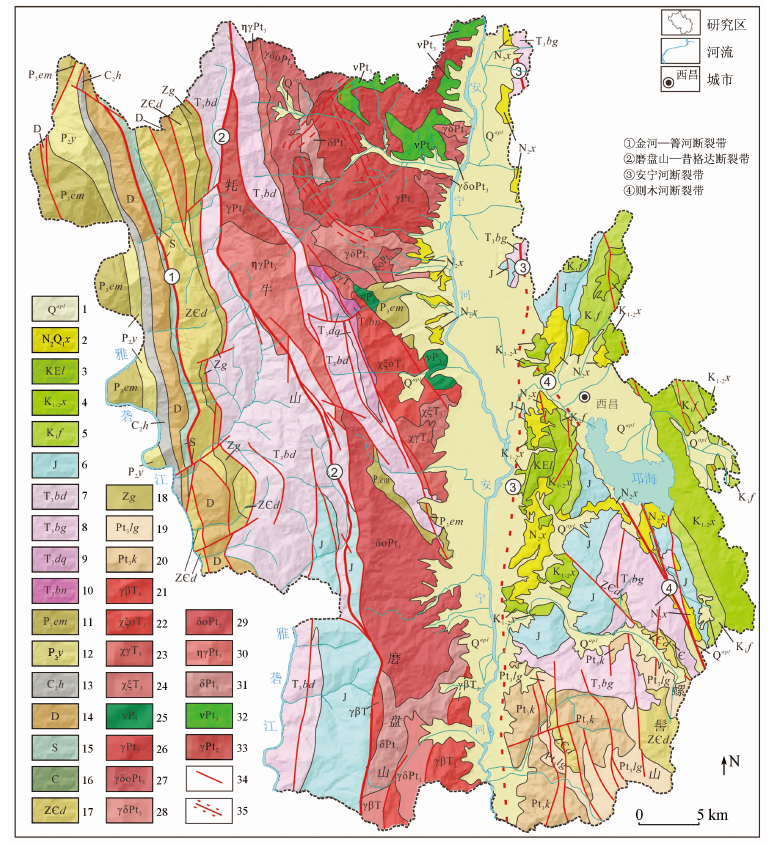
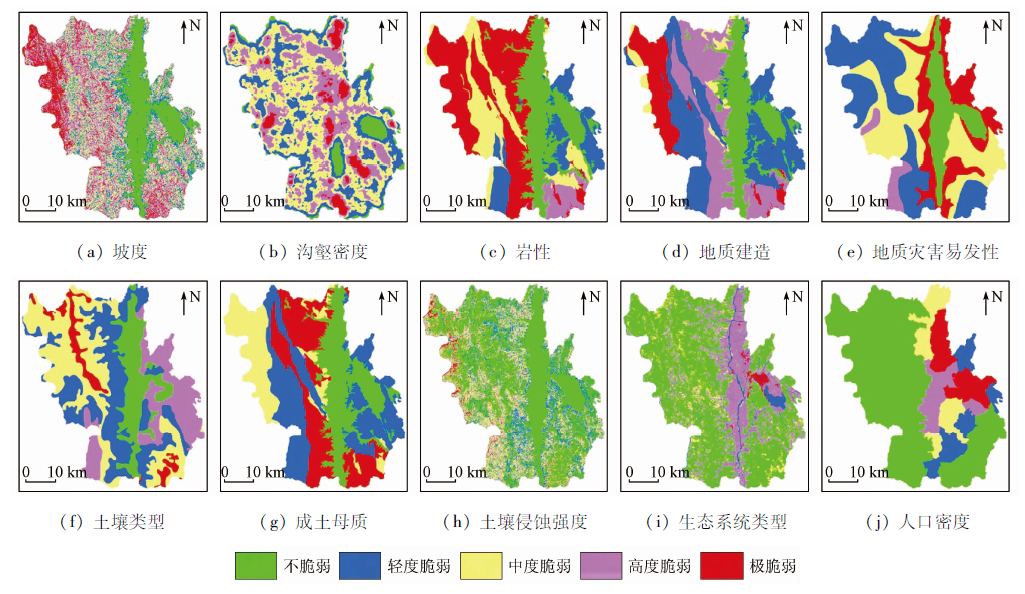
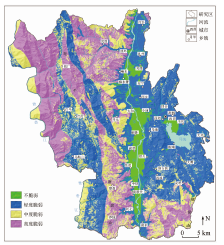
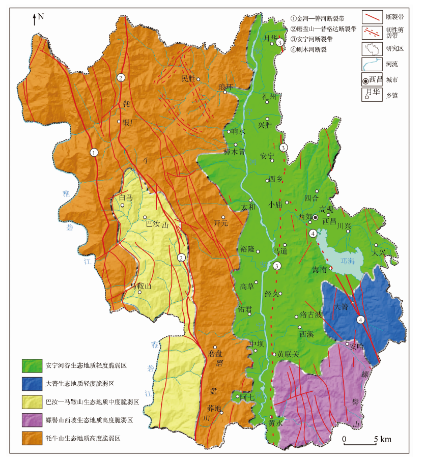
The eco-geological vulnerability assessment of Xichang City, Sichuan Province was performed in this study to provide bases for the ecological protection and restoration of the city. Firstly, an assessment indicator system was constructed, for which 10 major influencing factors of the eco-geological vulnerability in Xichang City were selected according to the eco-geological survey and comprehensive research. Then the eco-geological vulnerability assessment of Xichang City was conducted using the improved analytic hierarchy process (AHP) and the geographic information system (GIS). The results are as follows. Xichang City suffers from vulnerable eco-geology. The areas with moderate-high eco-geological vulnerability account for 50.14%, although no areas suffer extreme eco-geological vulnerability. The areas not suffering eco-geological vulnerability and those with slight eco-geological vulnerability are concentrated in the Anning River valley and the Qionghai Lake Basin, while the areas with moderate-high eco-geological vulnerability are mainly distributed in the Maoniu Mountain area in the western part of Xichang City and the Luoji Mountain area in the southeastern part of the city. Overall, the whole city includes five areas with eco-geological vulnerability, namely two areas with slight eco-geological vulnerability in the Anning River Valley (I) and Daqing (II), one area with moderate eco-geological vulnerability in the Baru-Ma’anshan area (III), and two areas with high eco-geological vulnerability on the western slope of the Luoji mountain (Ⅳ) and in the Maoniu Mountain (Ⅴ). Different ecological protection and restoration schemes and different development and construction measures should be implemented for different eco-geologically vulnerable areas in the city.

Key wordseco-geology    vulnerability    evaluation and zoning    Xichang City
收稿日期: 2021-01-13      出版日期: 2021-12-23
ZTFLH:  TP79  
基金资助:中国地质调查局项目“大凉山区生态地质调查”(DD20190542)
通讯作者: 欧阳渊
作者简介: 张景华(1978-),男,学士,高级工程师,从事遥感与生态地质调查与研究工作。Email: zjinghua@mail.cgs.gov.cn
引用本文:   
张景华, 欧阳渊, 刘洪, 黄瀚霄, 张腾蛟, 李富, 李樋. 基于主控要素的生态地质脆弱性评价——以四川省西昌市为例[J]. 自然资源遥感, 2021, 33(4): 181-191.
ZHANG Jinghua, OUYANG Yuan, LIU Hong, HUANG Hanxiao, ZHANG Tengjiao, LI Fu, LI Tong. Eco-geological vulnerability assessment based on major controlling factors: A case study of Xichang City, Sichuan Province. Remote Sensing for Natural Resources, 2021, 33(4): 181-191.
链接本文:  
https://www.gtzyyg.com/CN/10.6046/zrzyyg.2021012      或      https://www.gtzyyg.com/CN/Y2021/V33/I4/181
Fig.1  西昌市地质简图
1.第四系: 冲洪积物; 2.新近系-第四系昔格达组: 粉砂岩; 3.白垩-古近系雷打树组: 粉砂岩、泥岩为主; 4.中下白垩统小坝组: 粉砂质泥岩、泥岩为主; 5.下白垩统飞天山组: 粉砂岩、泥岩为主; 6.侏罗系官沟组、牛滚凼组、新村组、益门组: 泥岩、粉砂岩为主; 7.上三叠统宝顶组: 长石石英砂岩为主; 8.上三叠统白果湾组: 长石石英砂岩为主; 9.上三叠统大荞地组: 长石石英砂岩为主; 10.上三叠统丙南组: 板岩为主; 11.上二叠统峨眉山玄武岩组: 玄武岩为主; 12.中二叠统阳新组: 灰岩为主; 13.上石炭统黄龙组: 灰岩、泥质灰岩、白云岩为主; 14.泥盆系干沟组、烂泥箐组、曲靖组: 灰岩、白云岩为主; 15.志留系稗子田组: 灰岩、白云岩、钙质页岩为主; 16.寒武系: 筇竹寺组、沧浪铺组,粉砂岩、泥岩为主; 17.震旦-寒武系灯影组: 白云岩为主; 18.震旦系观音崖组: 灰岩、泥岩为主; 19.上元古界列古六组: 酸性火山碎屑岩; 20.上元古界开建桥组: 酸性火山碎屑岩; 21.晚三叠世黑云母花岗岩; 22.晚三叠世钠闪石英正长岩; 23.晚三叠世钠闪花岗岩; 24.晚三叠世钠闪正长岩; 25.晚二叠世辉长岩; 26.新元古代花岗岩; 27.新元古代英云闪长岩; 28.新元古代花岗闪长岩; 29.新元古代石英闪长岩; 30.新元古代二长花岗岩; 31.新元古代闪长岩; 32.新元古代辉长岩; 33.中元古代花岗岩; 34.断裂带; 35.韧性剪切带
生态地
质条件
生态地质要素 不脆弱 轻度脆弱 中度脆弱 高度脆弱 极脆弱
地形地貌 坡度/(°) <8 [8,15) [15,25) [25,35] >35
沟壑密度/(km·km-2) [0,1.09) [1.09,1.69) [1.69,2.09) [2.09,2.58) [2.58,4.05]
地质环境 地层岩性 Q,N2Q1x KEl,K1-2x,K1f,
J
T3bd,T3bg,T3dq,
T3bn
$\rlap{—}C$2,Pt3lg,Zg P2y,C2h,D,S,Z$\rlap{—}C$d,
玄武岩,花岗岩,闪长岩
地质建造 第四纪陆相松散堆积建造 新近纪陆相碎屑岩建造、侏罗纪-白垩纪陆相碎屑岩建造、三叠纪陆相碎屑岩建造 二叠纪陆相基性岩建造、青白口纪基性岩建造 三叠纪陆相中酸性岩建造、前寒武纪中酸性火山岩建造、前寒武纪中酸性岩建造 震旦纪-二叠纪海相-海陆过度陆相碳酸盐岩建造
地质灾害易发性 不易发区 低易发区 中易发区 高易发区 极易发区
土壤 土壤类型 水稻土 红壤 棕壤、暗棕壤、黄棕壤 紫色土 石灰土、黑毡土
成土母质 第四纪冲洪积风化物、新近纪泥岩类风化物 侏罗纪-白垩泥岩类风化物、三叠纪砂岩类风化物 三叠纪中性岩类风化物、二叠纪基性岩类风化物、三叠纪基性岩类风化物、震旦纪-二叠纪碳酸盐岩类风化物、寒武纪泥岩类风化物、前寒武纪基性岩类风化物 三叠纪泥质变质类风化物 三叠纪酸性岩类风化物、前寒武纪酸性岩类风化物
土壤侵蚀强度 微度 轻度 中度 强烈 极强烈、剧烈
生态 生态系统类型 森林生态系统 湿地生态系统 草地生态系统 农田生态系统 城镇生态系统
人口密度/(人·km-2) <70.98 70.98~190.66 190.66~345.51 345.51~547.32 >547.32
分级赋值(C) 1 3 5 7 9
分级标准(SS) [1.0,2.0) [2.0,4.0) [4.0,6.0) [6.0,8.0] >8.0
Tab.1  西昌市生态地质脆弱性评价指标
数据名称 数据来源
西昌市行政区划图 凉山彝族自治州自然资源与规划局
西昌市DEM数据 地理空间数据云(http: //www.gscloud.cn)GDEM V2 30 m分辨率
西昌市地质图 中国地质调查局西昌市幅(G48C001001)
1∶25万地质图(公开版)
西昌市地质灾害
易发分区图
四川省地质调查院(2013年)
数据名称 数据来源
西昌市土壤类型图 凉山彝族自治州土壤普查办公室(1987年)
西昌市土壤侵蚀强度数据 遥感近似计算
西昌市土地利用类型数据 遥感提取
西昌市人口密度数据 西昌市2019年国民经济和社会发展统计公报
Tab.2  数据来源与描述
Fig.2  西昌市生态地质脆弱性单因子评价图
A B1 B2 B3 B4 B5 B6 B7 B8 B9 B10 权重(W) 排序
B1 1 1/3 1/3 1/5 3 1/3 1/3 3 1/3 3 0.055 6 6
B2 3 1 1/3 1/5 2 1/3 1/3 1/2 1/3 2 0.052 4 7
B3 3 3 1 1/3 3 3 3 4 3 4 0.175 0 2
B4 5 5 3 1 4 4 4 5 4 5 0.280 3 1
B5 1/3 1/2 1/3 1/4 1 1/3 1/3 1/3 1/3 3 0.036 5 9
B6 3 3 1/3 1/4 3 1 1/3 3 3 4 0.107 5 4
B7 3 3 1/3 1/4 3 3 1 3 3 4 0.134 5 3
B8 1/3 2 1/4 1/5 3 1/3 1/3 1 1/3 2 0.048 0 8
B9 3 3 1/3 1/4 3 1/3 1/3 3 1 3 0.084 0 5
B10 1/3 1/2 1/4 1/5 1/3 1/4 1/4 1/2 1/3 1 0.026 1 10
Tab.3  西昌市生态地质脆弱性评价判断矩阵与层次排序
Fig.3  西昌市生态地质脆弱性评价图
生态地质脆弱性分级 面积/km2 百分比/%
不脆弱 208.31 7.85
轻度脆弱 1 115.41 42.01
中度脆弱 543.43 20.47
高度脆弱 787.85 29.67
合计 2 655.00 100.00
Tab.4  西昌市生态地质脆弱性面积统计
Fig.4  西昌市生态地质脆弱性分区图
生态地质脆
弱性分区
面积/
km2
占比/
%
涉及乡镇 生态地质背景 主要生态
地质问题
生态保护与建设重点 产业开发策略
安宁河谷生态地质轻度脆弱区(Ⅰ) 851.75 32.08 月华、礼州、兴胜、响水、樟木箐、安宁、西乡、四合、太和、小庙、裕隆、马道、西郊、川兴、大兴、高草、经久、海南、洛古波、西溪、佑军、黄联关、中坝 生态地质脆弱性以轻度脆弱为主,安宁河谷地带不脆弱; 地貌主要为中山宽谷平原和构造侵蚀剥蚀中山; 出露地层主要为第四系冲洪积物、昔格达组和白垩系小坝组; 安宁河断裂带和则木河断裂带纵贯全区 水土流失、地质灾害 加强工业“三废”污染的防治,加快污水处理设施建设,对大气污染进行重点监控,加强城郊面源污染的治理,做好城区和郊区景观生态建设和保护,保护好邛海湿地及其水质 工农业综合开发,安宁河谷发展生态农业; 在工业发展和城市发展过程中,发展循环经济和清洁产业; 依托邛海发展生态旅游业
大箐生态地质轻度脆弱区(Ⅱ) 128.48 4.84 大箐、安哈 生态地质脆弱性以轻度脆弱为主; 地貌主要为构造侵蚀剥蚀中山; 出露地层主要为三叠系白果湾组、侏罗系和白垩系小坝组; 则木河断裂带纵贯全区 水土流失 保育好中亚热带常绿针叶、阔叶林生态系统,维护森林生态系统的水源涵养、水土保持和生物多样性维持的功能,为邛海的生态安全、水源保证做出重要贡献 以保护为主,适当发展生态林业
巴汝—马鞍山生态地质中度脆弱区(Ⅲ) 333.50 12.56 巴汝、马鞍山 生态地质脆弱性以中度脆弱为主; 地貌主要为构造侵蚀剥蚀中山,少量构造侵蚀剥蚀高山; 出露地层主要为三叠系宝顶组、侏罗系和白垩系小坝组; 磨盘山—昔格达断裂带纵贯全区 水土流失、地质灾害、植被退化 维护和恢复山地森林生态系统,加强植树造林,以改善森林结构,提高水源涵养能力和水土保持能力 以保护为主,适当发展生态林业、牧业,重点维护和恢复山地森林生态系统,改善林业生态环境,从而促进区域经济持续发展
螺髻山西坡生态地质高度脆弱区(Ⅳ) 189.47 7.14 黄水、安哈 生态地质脆弱性以高度脆弱为主; 地貌主要为构造侵蚀剥蚀中山,少量构造侵蚀剥蚀高山; 出露地层主要为震旦系灯影组、南华系开建桥组、青白口-南华系苏雄组; 断裂发育 水土流失、地质灾害 着重于生态恢复和水土流失治理,保护地质环境,降低地质灾害的发生频率,陡坡地区森林生态系统水源涵养功能对保证安宁河的稳定和安全十分重要,必须通过山地自然生态恢复与维护来增强水源涵养能力 以保护为主,适当发展生态林业
牦牛山生态地质高度脆弱区(Ⅴ) 1151.80 43.38 民胜、琅环、银厂、开元、白马、磨盘、荞地、阿七 生态地质脆弱性以高度脆弱为主; 地貌主要为构造侵蚀剥蚀中山,少量构造侵蚀剥蚀高山; 出露地层从震旦系到侏罗系,岩性复杂多样; 断裂发育,箐河—金河断裂带和盘山—昔格达断裂带纵贯全区 水土流失、地质灾害、植被退化 着重于生态恢复和水土流失治理,保护地质环境,降低地质灾害的发生频率,陡坡地区森林生态系统水源涵养功能对保证雅砻江的稳定和安全十分重要,必须通过山地自然生态恢复与维护来增强水源涵养能力; 加强生态公益林的建设和保育,对生态公益林逐步进行改造与建设,使其向常绿阔叶林演化,提高其生态保护和水源涵养的功效 以保护为主,适当发展生态林业
Tab.5  西昌市生态地质脆弱性分区与保护建议
[1] 孙儒泳, 李庆芬, 牛翠娟, 等. 基础生态学[M]. 北京: 高等教育出版社, 2002:1-4.
Sun R Y, Li Q F, Niu C J, et al. Basic ecology[M]. Beijing: Higher Education Press, 2002:1-4.
[2] Trofimov V T. 生态地质学——地质科学的新分支[J]. 地学前缘, 2001,8(1):27-35.
Trofimov V T. Ecological geology:A novel branch of geological sciences[J]. Earth Science Frontiers, 2001,8(1):27-35.
[3] Trofimov V T. 生态地质条件评估的方法、原理和标准[J]. 地学前缘, 2004,11(2):533-542.
Trofimov V T. Approaches,principles and criteria of evaluation of ecological geological conditions[J]. Earth Science Frontiers, 2004,11(2):533-542.
[4] 刘丙祥, 李玉成, 孙丙华, 等. “大地质”背景下高校地质学专业生态地质学课程教学探讨[J]. 生物学杂志, 2017,34(2):124-127.
Liu B X, Li Y C, Sun B H, et al. On teaching the course of ecological geology based on the background of the strategy of “the great geology”[J]. Journal of Biology, 2017,34(2):124-127.
[5] 聂洪峰, 肖春蕾, 郭兆成. 探寻生态系统运行与演化的秘密——生态地质调查思路及方法解读[J]. 国土资源科普与文化, 2019,6(4):4-13.
Nie H F, Xiao C L, Guo Z C. Exploring the secrets of ecosystem operation and evolution:Interpretation of ecological geological survey ideas and methods[J]. Scientific and Cultural Popularization of Land and Resources, 2019,6(4):4-13.
[6] 张景华, 欧阳渊, 刘洪, 等. 西昌市生态地质特征与脆弱性评价[M]. 武汉: 中国地质大学出版社, 2020:1-5.
Zhang J H, Ouyang Y, Liu H, et al. Eco-geological characteristics and vulnerability evaluation of Xichang City[M]. Wuhan: China University of Geosciences Press, 2020:1-5.
[7] 陈树旺, Antonina A Z, 邢德和, 等. 铁岭地区生态地质研究[M]. 北京: 地质出版社, 2011:1-2.
Chen S W, Antonina A Z, Xing D H, et al. Eco-geological study in Tieling area[M]. Beijing: Geological Publishing House, 2011:1-2.
[8] 陈树旺, 邢德和, 丁秋红, 等. 生态地质调查评价——以辽宁铁岭地区为例[J]. 地质与资源, 2012,21(6):540-545.
Chen S W, Xing D H, Ding Q H, et al. Eco-geological survey and evaluation:A case study of Tieling area,Liaoning Province[J]. Geology and Resources, 2012,21(6):540-545.
[9] 汪振立. “生态地质”课程教学初探[J]. 中国地质教育, 2012,(1):17-20.
Wang Z L. Preliminary study on teaching the course of ecological geology[J]. Chinese Geological Education, 2012,(1):17-20.
[10] 汪振立. 生态地质[M]. 北京: 地质出版社, 2013:1-5.
Wang Z L. Eco-geology[M]. Beijing: Geological Publishing House, 2013:1-5.
[11] 吴传璧, 刘燕平. 生态地质调查工作——俄罗斯的状况与启示[J]. 国土资源情报, 2003,(12):36-42.
Wu C B, Liu Y P. Eco-geological survey:Situation and enlightenment of Russia[J]. Land and Resources Information, 2003,(12):36-42.
[12] 王长生, 王大可. 试论1:5万生态地质调查[J]. 中国区域地质, 1997,16(1):56-59.
Wang C S, Wang D K. On the 1:50 000 ecological geological investigation[J]. Regional Geology of China, 1997,16(1):56-59.
[13] 王长生, 王大可. 生态地质学的创立及其在大巴山区的初步应用[J]. 大自然探索, 1998,17(6):68-70.
Wang C S, Wang D K. Production of ecological geology and its applications in the Daba Mountain[J]. Exploration of Nature, 1998,17(66):68-70.
[14] 侯春堂, 李瑞敏, 冯翠娥, 等. 区域农业生态地质调查内容与方法——以河北平原为例[J]. 地质科技情报, 2002,21(1):66-70.
Hou C T, Li R M, Feng C E, et al. An approach to survey contents and methods of regional and agroecological geology:A case study in Hebei Plain[J]. Geological Science and Technology Information, 2002,21(1):66-70.
[15] 何政伟, 黄润秋, 孙传敏, 等. 浅议“生态地质学”[J]. 国土资源科技管理, 2003,3(20):69-72.
He Z W, Huang R Q, Sun C M, et al. A brief discussion on ‘eco-geology’[J]. Scientific and Technological Management of Land and Resources, 2003,3(20):69-72.
[16] 杨忠芳, 奚小环, 成杭新, 等. 区域生态地球化学评价核心与对策.第四纪研究[J], 2005,25(3):276-284.
Yang Z F, Xi X H, Cheng H X, et al. The core and countermeasures of regional ecological geochemical assessment[J]. Quaternary Sciences, 2005,25(3):276-284.
[17] 孙立广. 南极无冰区生态地质学及其形成与发展[J]. 自然杂志, 2006,28(3):150-154.
Sun L G. The formation and development of eco-geology in ice-free area,Antarctica[J]. Chinese Journal of Nature, 2006,28(3):150-154.
[18] Trofimov V T, Andreeva T V. Ecological geological systems and their types,position in the ecosystems structure and tasks of the investigation[J]. Earth Science Frontiers, 2010,17(2):425-438.
[19] 赵平. 新时代生态地质勘查工作的基本内涵与架构[J]. 中国煤炭地质, 2018,30(10):1-5.
Zhao P. Fundamental connotation and framework of eco-geological exploration in new era[J]. Coal Geology of China, 2018,30(10):1-5.
[20] 李鹤, 张平宇, 程叶青. 脆弱性的概念及其评价方法[J]. 地理科学进展, 2008,27(2),18-24.
doi: 10.11820/dlkxjz.2008.02.003
Li H, Zhang P Y, Cheng Y Q. Concepts and assessment methods of vulnerability[J]. Progress in Geography, 2008,27(2),18-24.
[21] 李莉, 王晓婷, 王辉. 脆弱性内涵、评价与研究趋势综述[J]. 中国渔业经济, 2010,28(3),161-169.
Li L, Wang X T, Wang H. Review of content,evaluation and research trends of vulnerability[J]. Chinese Fisheries Economics, 2010,28(3),161-169.
[22] 姚建, 丁晶, 艾南山. 岷江上游生态脆弱性评价[J]. 长江流域资源与环境, 2004,13(4):380-384.
Yao J, Ding J, Ai N S. Assessment of ecological vulnerability in upper reaches of Mingjiang River[J]. Resources and Environment in the Yangtze Basin, 2004,13(4):380-384.
[23] 沈珍瑶, 杨志峰, 曹瑜. 环境脆弱性研究述评[J]. 地质科技情报, 2003,22(3):91-94.
Shen Z Y, Yang Z F, Cao Y. Review on environment vulnerability research[J]. Geological Science and Technology Information, 2003,22(3):91-94.
[24] 徐庆勇, 黄玫, 刘洪升, 等. 基于RS和GIS的珠江三角洲生态环境脆弱性综合评价[J]. 应用生态学报, 2011,22(11):2987-2995.
Xu Q Y, Huang M, Liu H S, et al. Integrated assessment of eco-environmental vulnerability in Pearl River Delta based on RS and GIS[J]. Chinese Journal of Applied Ecology, 2011,22(11):2987-2995.
[25] 卢远, 苏文静, 华璀. 基于景观格局和生态敏感性的左江流域生态脆弱性分析[J]. 水土保持研究, 2011,18(3):78-87.
Lu Y, Su W J, Hua C. Analysis of ecological vulnerability in Zuojiang River Basin based on landscape pattern and ecosystem sensitivity[J]. Research of Soil and Water Conservation, 2011,18(3):78-87.
[26] 李念春, 袁辉. 黄河三角洲高效生态经济区生态环境脆弱性评价研究[J]. 山东国土资源, 2015,31(10):57-61.
Li N C, Yuan H. Evaluation and study on ecological vulnerability of efficient ecological economic zone in the Yellow River Delta area[J]. Shandong Land and Resources, 2015,31(10):57-61.
[27] 侯文娟, 高江波, 彭韬, 等. 结构-功能-生境框架下的西南喀斯特生态系统脆弱性研究进展[J]. 地理科学进展, 2016,35(3):320-330.
doi: 10.18306/dlkxjz.2016.03.006
Hou W J, Gao J B, Peng T, et al. Review of ecosystem vulnerability studies in the karst region of Southwest China based on a structure-function-habitat framework[J]. Progress in Geography, 2016,35(3):320-330.
[28] 邵秋芳, 彭培好, 黄洁, 等. 长江上游安宁河流域生态环境脆弱性遥感监测[J]. 国土资源遥感, 2016,28(2):175-181.doi: 10.6046/gtzyyg.2016.02.27.
doi: 10.6046/gtzyyg.2016.02.27
Shao Q F, Peng P H, Huang J, et al. Monitoring eco-environmental vulnerability in Anning River Basin in the upper reaches of the Yangtze River using remote sensing techniques[J]. Remote Sensing for Land and Resources, 2016,8(2):175-181.doi: 10.6046/gtzyyg.2016.02.27.
doi: 10.6046/gtzyyg.2016.02.27
[29] 姚昆, 张存杰, 何磊, 等. 雅砻江中上游流域生态环境脆弱性动态评价及预测[J]. 国土资源遥感, 2020,32(4):199-208.doi: 10.6046/gtzyyg.2020.04.25.
doi: 10.6046/gtzyyg.2020.04.25
Yao K, Zhang C J, He L, et al. Dynamic evaluation and prediction of ecological environment vulnerability in the middle-upper reaches of the Yalong River[J]. Remote Sensing for Land and Resources, 2020,32(4):199-208.doi: 10.6046/gtzyyg.2020.04.25.
doi: 10.6046/gtzyyg.2020.04.25
[30] 陈开伟. 西昌市天然林资源保护工程建设成效评价[J]. 宁夏农林科技, 2012,53(10):85-86.
Chen K W. Effects evaluation on natural forest protection engineering construction of Xichang City[J]. Ningxia Journal of Agriculture and Forestry Science and Technology, 2012,53(10):85-86.
[31] Hong W Y, Jiang R R, Yang C Y, et al. Establishing an ecological vulnerability assessment indicator system for spatial recognition and management of ecologically vulnerable areas in highly urbanized regions:A case study of Shenzhen,China[J]. Ecological Indicators, 2016(69):540-547.
[32] Zhang F, Liu X P, Zhang J Q, et al. Ecological vulnerability assessment based on multi-sources data and SD model in Yinma River Basin,China[J]. Ecological Modelling, 2017(349):41-50.
[33] Zhao J C, Jia G X, Tian Y, et al. Environmental vulnerability assessment for Mainland China based on entropy method[J]. Ecological Indicators, 2018(91):410-422.
[34] Yang Z, Li W P, Li X Q, et al. Assessment of eco-geo-environment quality using multivariate data:A case study in a coal mining area of Western China[J]. Ecological Indicators, 2019(107):1-13.
[35] Wei W, Shi S N, Zhang X Y, et al. Regional-scale assessment of environmental vulnerability in an arid inland basin[J]. Ecological Indicators, 2020(109):1-19.
[36] 刘洪, 黄瀚霄, 欧阳渊, 等. 基于地质建造的土壤地质调查及应用前景分析——以大凉山区西昌市为例[J]. 沉积与特提斯地质, 2020,40(1):91-105.
Liu H, Huang H X, Ouyang Y, et al. Soil's geologic investigation in Daliangshan,Xichang,Sichuan[J]. Sedimentary Geology and Tethyan Geology, 2020,40(1):91-105.
[37] 张景华, 高慧, 欧阳渊, 等. 贵州省黔西县土壤侵蚀敏感性评价[J]. 中国水土保持科学, 2018,16(2):88-94.
Zhang J H, Gao H, Ouyang Y, et al. Sensitivity evaluation of soil erosion in Qianxi County of Guizhou Province[J]. Science of Soil and Water Conservation, 2018,16(2):88-94.
[38] 王克晓, 陈刚, 陈伟涛, 等. 生态地质环境评价方法研究[J]. 测绘科学, 2015,40(7):78-82.
Wang K X, Chen G, Chen W T, et al. Comprehensive assessment of eco-geologyical environment[J]. Science of Surveying and Mapping, 2015,40(7):78-82.
[39] 王尧, 张茂省, 杨建锋. 中国地质环境脆弱性评价[J]. 西北地质, 2019,52(2):199-206.
Wang Y, Zhang M S, Yang J F. Evaluation research on the fragility of geological environment in China[J]. Northwestern Geology, 2019,52(2):199-206.
[40] Satiprasad S, Anirban D, Amlanjyoti K. Environmental vulnerability assessment using grey analytic hierarchy process based model[J]. Environmental Impact Assessment Review, 2016(56):145-154.
[41] 张茂省, 王尧, 薛强. 资源环境承载力评价理论方法与实践[J]. 西北地质, 2019,52(2):1-11.
Zhang M S, Wang Y, Xue Q. Evaluation resource environment carrying capacity:Theoretical method and practice[J]. Northwestern Geology, 2019,52(2):1-11.
[42] 张晓东, 刘湘南, 赵志鹏, 等基于层次分析法的盐池县地质灾害危险性评价[J]. 国土资源遥感, 2019,31(3):183-192.doi: 10.6046/gtzyyg.2019.03.23.
doi: 10.6046/gtzyyg.2019.03.23
Zhang X D, Liu X N, Zhao Z P, et al. Geological disaster hazard assessment in Yanchi County based on AHP[J]. Remote Sensing for Land and Resources, 2019,31(3):183-192.doi: 10.6046/gtzyyg.2019.03.23.
doi: 10.6046/gtzyyg.2019.03.23
[43] 郑续, 苗俊霞, 王东, 等. 黄河中上游地质灾害高发县国土空间适宜性评价及功能分区——以陕西省延川县为例[J]. 西北地质, 2020,53(2):289-297.
Zheng X, Wang J X, Wang D, et al. Suitability evaluation and functional division of land space development in the high-incidence area of geological hazards in the Yellow River:A case study of Yanchuan County,Shangxi Province[J]. Northwestern Geology, 2020,53(2):289-297.
[44] 赵玉灵. 基于层次分析法的矿山环境评价方法研究——以海南岛为例[J]. 国土资源遥感, 2020,32(1):148-153.doi: 10.6046/gtzyyg.2020.01.20.
doi: 10.6046/gtzyyg.2020.01.20
Zhao Y L. Study and application of analytic hierarchy process of mine geological environment:A case study in Hainan Island[J]. Remote Sensing for Land and Resources, 2020,32(1):148-153.doi: 10.6046/gtzyyg.2020.01.20.
doi: 10.6046/gtzyyg.2020.01.20
[45] 徐建华. 计量地理学[M].2版. 北京: 高等教育出版社, 2014:234-239.
Xu J H. Quantitative geography[M].2nd ed. Beijing: Higher Education Press, 2014:234-239.
[1] 杨雯娜, 周亮, 孙东琪. 基于分区-集成的黄河流域生态脆弱性评价[J]. 自然资源遥感, 2021, 33(3): 211-218.
[2] 姜文, 秦其明. 基于GIS的路网应急疏散脆弱性研究[J]. 国土资源遥感, 2019, 31(1): 277-282.
[3] 邵秋芳, 彭培好, 黄洁, 刘智, 孙小飞, 邵怀勇. 长江上游安宁河流域生态环境脆弱性遥感监测[J]. 国土资源遥感, 2016, 28(2): 175-181.
[4] 杨斌, 詹金凤, 李茂娇. 岷江上游流域环境脆弱性评价[J]. 国土资源遥感, 2014, 26(4): 138-144.
[5] 赵福岳.
松辽平原第四纪地质历史演化规律研究
[J]. 国土资源遥感, 2010, 22(s1): 152-158.
[6] 和正民, 燕云鹏, 冯敏, 王红瑞. 青藏高原生态地质环境遥感综合评价系统的设计与实现[J]. 国土资源遥感, 2010, 22(s1): 30-34.
[7] 燕云鹏, 和正民.
基于Arc Engine的青藏高原生态地质环境遥感监测数据库系统建设
[J]. 国土资源遥感, 2010, 22(s1): 35-38.
[8] 和正民, 燕云鹏, 冯敏, 王红瑞, 王建超. 区域生态地质环境综合评价系统设计与示范应用——以青海省为例[J]. 国土资源遥感, 2007, 19(4): 118-121.
[9] 孙延贵, 姚安平, 巨生成, 王冬青, 张琨. 青藏高原中北部地貌变形的遥感表征及其生态地质学意义[J]. 国土资源遥感, 2004, 16(2): 47-50,55.
Viewed
Full text


Abstract

Cited

  Shared   
  Discussed   
京ICP备05055290号-2
版权所有 © 2015 《自然资源遥感》编辑部
地址:北京学院路31号中国国土资源航空物探遥感中心 邮编:100083
电话:010-62060291/62060292 E-mail:zrzyyg@163.com
本系统由北京玛格泰克科技发展有限公司设计开发