An analysis of rainstorm-induced landslides in northeast Chongqing on August 31, 2014 based on interpretation of remote sensing images
LIU Zhizhong1(), SONG Yingxu2(), YE Runqing3
1. China Railway 11th Bureau Group Fourth Engineering Co., Ltd., Wuhan 100855, China 2. Jiangxi Engineering Laboratory on Radioactive Geoscience and Big Data Technology, School of Information Engineering, East China University of Technology, Nanchang 330013, China 3. Wuhan Center of China Geological Survey (Central South China Innovation Center for Geosciences), Wuhan 430205, China
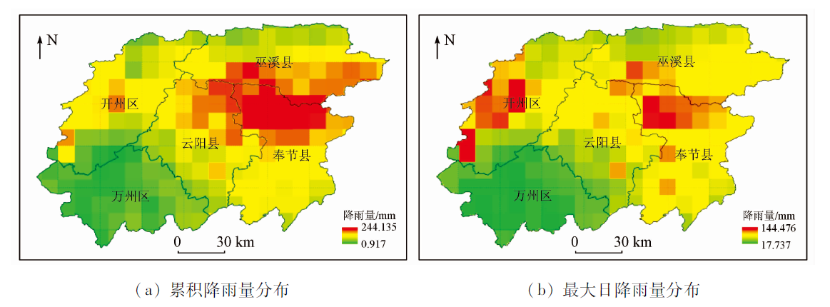
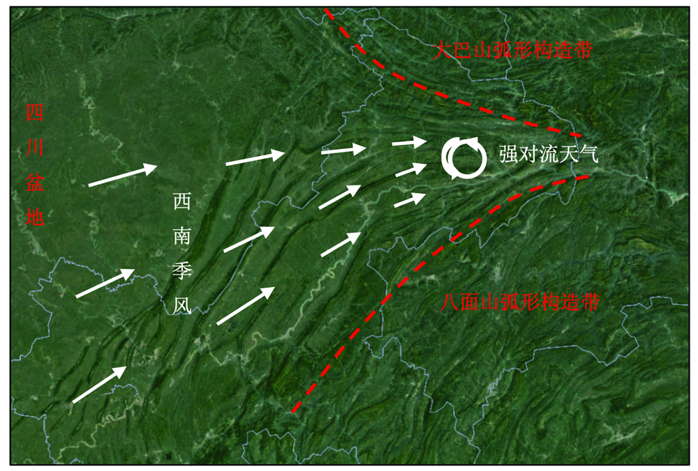
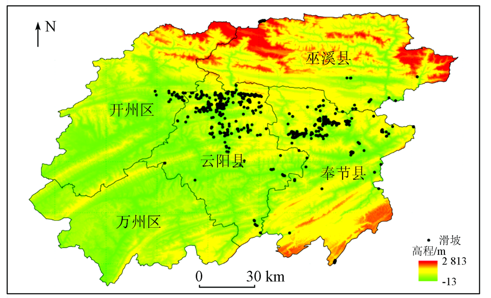
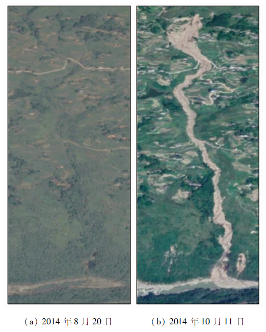
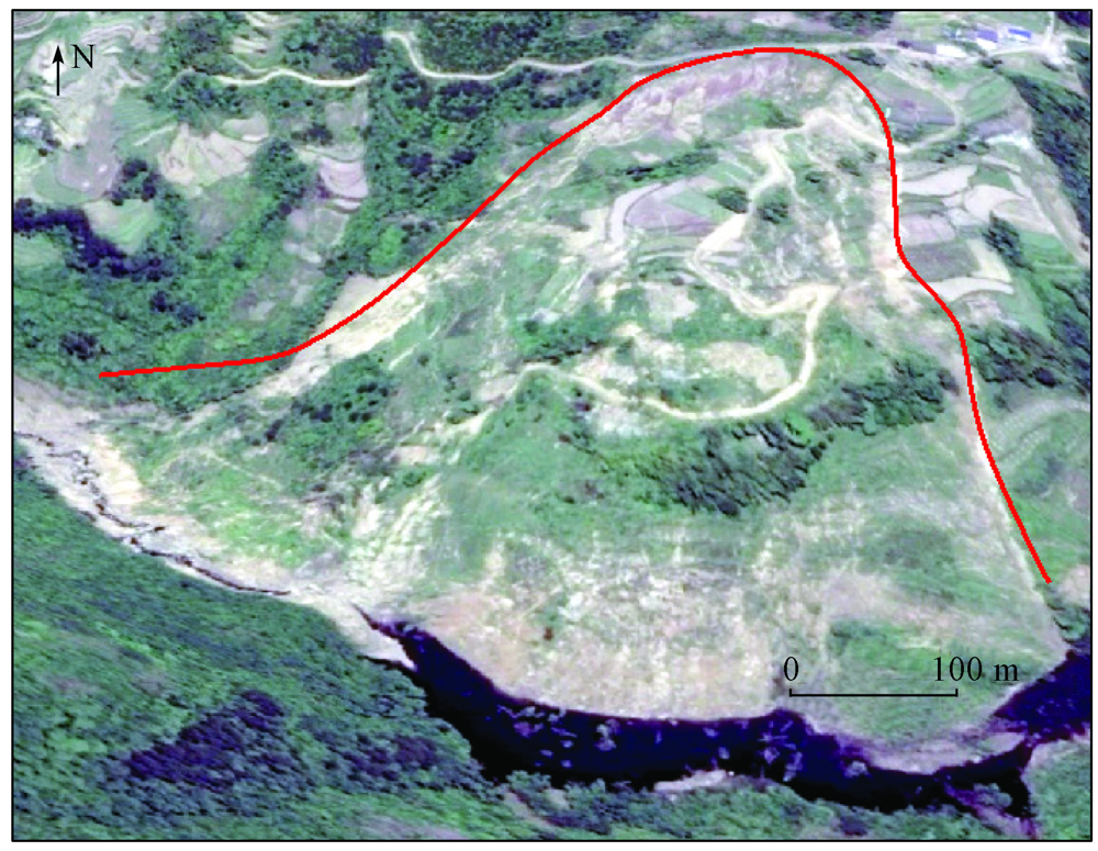
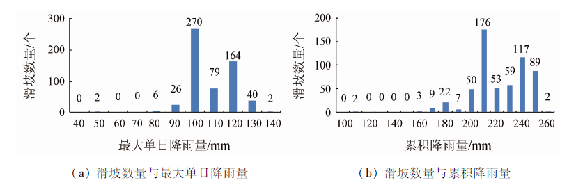
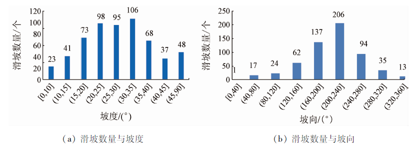
A rainstorm struck northeast Chongqing from August 31 to September 2, 2014. It triggered extensive landslides and resulted in casualties and serious economic losses. To learn the condition of the landslides induced by the rainstorm and analyze the relationship between the landslides and rainfall, this study obtains the distribution of the landslides through the interpretation of high-resolution satellite remote sensing images before and after the rainstorm using RS and GIS techniques. It can be concluded that complicated geological tectonic conditions and corresponding unique tectonic erosion landform pattern make northeast Chongqing become the center of the rainstorm and also lead to the frequent occurrence of rainfall-triggered landslides in this area. Landslides will continuously occur when the maximum daily rainfall and accumulated rainfall exceed 80 mm and 160 mm, respectively, and extensive landslides will occur when the maximum daily rainfall and accumulated rainfall exceed 100 mm and 210 mm, respectively. Furthermore, landslides are the most liable to occur in windward slopes with a gradient of about 25°. Therefore, the regional topography should be taken into account in the analysis and prediction of rainfall-induced geological disasters to improve the accuracy of spatial and temporal prediction and analysis of geological hazards.
刘志中, 宋英旭, 叶润青. 渝东北2014年“8·31”暴雨诱发滑坡遥感解译与分析[J]. 自然资源遥感, 2021, 33(4): 192-199.
LIU Zhizhong, SONG Yingxu, YE Runqing. An analysis of rainstorm-induced landslides in northeast Chongqing on August 31, 2014 based on interpretation of remote sensing images. Remote Sensing for Natural Resources, 2021, 33(4): 192-199.
Yang J H, Jiang Z H, Wang P X, et al. Temporal and spatial characteristic of extreme precipitation event in China[J]. Climatic and Environmental Research, 2008,13(1):75-83.
Gu X H, Zhang Q, Kong D D, et al. Spatiotemporal patterns of extreme precipitation distributions with annual and seasonal scales and potential impact of tropical cyclones in China[J]. Scientia Geographica Sinica, 2017,37(6):929-937.
Zhang J, Gao Y Q, Xu W L, et al. Spatial and temporal analysis of extreme precipitation events in Yangtze River Basin[J]. Yangtze River, 2019,50(8):81-86.
Wang L S, Li Y G, Zhan Z. Distribution of rock landslide failed in 1981 triggered by torrential rain in Sichuan Basin[J]. Discovery of Nature, 1982(1):44-51.
[5]
柳源. 滑坡临界暴雨强度[J]. 水文地质工程地质, 1998(3):43-45.
Liu Y. Critical rainstorm intensity of landslide[J]. Hydrogeology and Engineering Geology, 1998(3):43-45.
Zhao P, Yang P L, Jiang L, et al. Situation of geologic hazards induced by heavy rainfall in northeast Chongqing[J]. Journal of Yangtze River Scientific Research Institute, 2017,34(10):50-56.
Chen J, Gao Z H, Wang S S, et al. A review on the development of aerial remote sensing geological survey technology in the Three Gorges Reservoir area[J]. Remote Sensing for Land and Resources, 2020,32(2):1-10.doi: 10.6046/gtzyyg.2020.02.01.
doi: 10.6046/gtzyyg.2020.02.01
[9]
Mantovani F, Soeters R, Westen C V. Remote sensing techniques for landslide studies and hazard zonation in Europe[J]. Geomorphology, 1996,15:213-225.
doi: 10.1016/0169-555X(95)00071-C
Song Y X. Research on dynamic evaluation of landslide risk based on integrated air-space-ground monitoring[D]. Wuhan:China University of Geosciences(Wuhan), 2019.
Wen G C, Zhang Z W, Xiao X J, et al. Rapid extraction method of post-disaster landslide information based on remote sensing data[J]. The Chinese Journal of Geological Hazard and Control, 2020,31(2):84-90.
[12]
Colesanti C, Wasowski J. Investigating landslides with space-borne synthetic aperture Radar (SAR) interferometry[J]. Engineering Geology, 2006,88(3-4):173-199.
doi: 10.1016/j.enggeo.2006.09.013
[13]
Kummerow C, Barnes W, Kozu T, et al. The tropical rainfall measuring mission(TRMM) sensor package[J]. Journal of Atmospheric and Oceanic Technology, 1998,15(2):809-817.
doi: 10.1175/1520-0426(1998)015<0809:TTRMMT>2.0.CO;2
Tang G Q, Wan W, Zeng Z Y, et al. An overview of the globe precipitation measurement(GPM) mission and it’s latest development[J]. Remote Sensing Technology and Application, 2015,30(4):607-615.
Wang P D, Li G P. Numerical experiments of the impact of Qin-Ba mountainous terrain on a rainstorm caused by southwest vortex[J]. Journal of Yunnan University, 2016,38(3):418-429.
 2021, Vol. 33
  ), 宋英旭2(